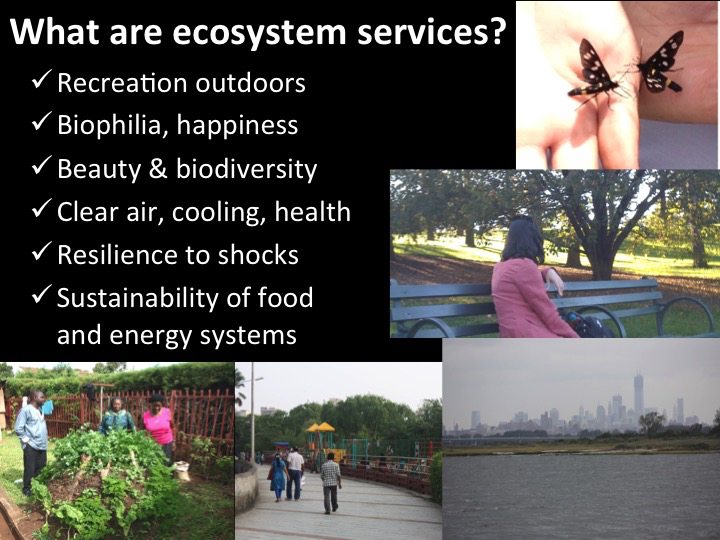
Here at The Nature of Cities, we write a great deal about the benefits of “green” cities, widely construed. In particular, we write that green infrastructure and biodiversity in cities have broad benefits for people, nature, and, indeed, for the world at large through their effects on sustainability and resilience. Green infrastructure is good for human health and quality of life, it reduces the carbon footprint of cities, it increases resilience by insulating us from storms, it helps create foci of community building, and so on. Furthermore, green cities are good for nature in the form of conservation. This constellation of benefits constitutes what we call ecosystem services.
Do we truly believe in the benefits of ecosystem services? If we do, then two important questions follow. First, who should enjoy these benefits? The answer is really self-evident: everyone. Does everyone currently enjoy these benefits, in cities around the world? In short, and emphatically: no.
If we believe in nature-based solutions to urban problems, then we must also believe in the fair and equitable access to such solutions. All green infrastructure designs and their implementations have elements of justice and equity built in. Stated another way: “green” is an issue of justice.
Traditionally, environmental justice discussions have focused on the distribution of environmental “bads”—namely, that environmental waste and pollution are disproportionally experienced by the poor. This issue isn’t solved.
There is a flip side to this equation, too, and that is whether there is equitable access to environmental “goods”, or, the positive benefits of ecosystem services. We are lagging here, also. Does everyone have access to benefits such as parks, street trees, open space, nature-based protection from storms? Broadly, the answer is no.
The idea of access to nature-based solutions is within the decision-making power of city governments around the world. And, as a matter of assessment, access is relatively easy to measure, and so it is straightforward to assess how near or far we are from the goal of full and equitable access to nature and open space.
It’s easy to measure access
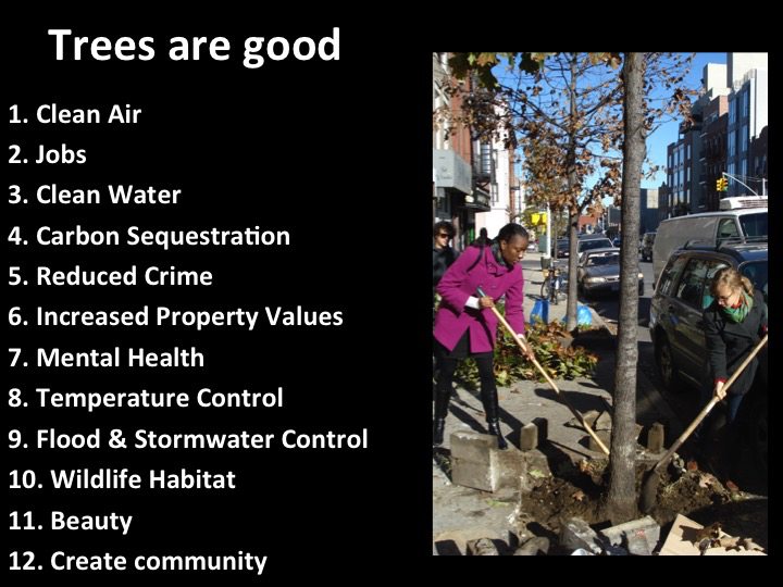
Trees are good. They have a role in providing clean air, jobs, carbon sequestration, reduced crime, increased property values, mental health benefits, temperature control, stormwater management, wildlife habitat, beauty, and livable neighborhoods. This is why across many cities in the United States and elsewhere, there are tree-lined streets. There are also streets that are not tree-lined. There is generally more tree canopy in wealthier neighborhoods.
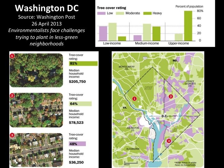
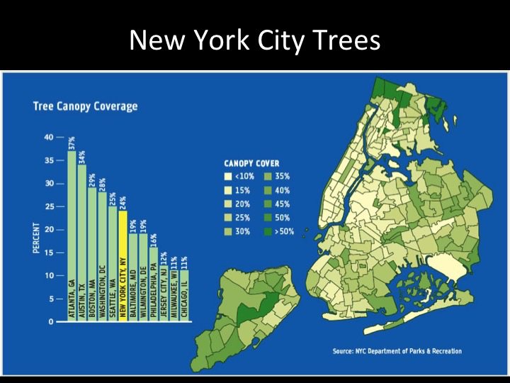
In Washington, DC, the Washington Post reported a strong correlation across neighborhoods between median household income and tree cover. The richer the neighborhood, the greener it was. New York City also exhibits dramatic spatial variation in tree cover. A thoughtful response to this disparity has been that new street trees planted in the “Million Trees” program are clustered in underserved neighborhoods. Such a clustering approach means that areas without a full complement of trees are directly brought to a complete set of trees, rather than remaining behind as trees are placed with equal frequency across all neighborhoods, without regard to need.
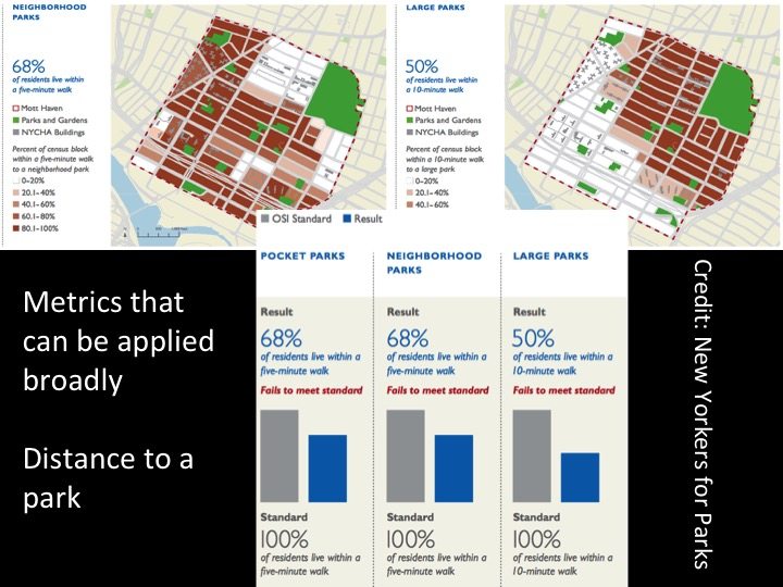
Similarly, access to parks is widely variable around the world. This variability is easy to measure. One of the goals of New York City’s sustainability plan (PlaNYC) is that every New Yorker should be within a five-minute walk of a park. (Let’s leave for another essay the idea of the quality of that park, and concentrate simply on access.) New Yorkers for Parks has done admirable work documenting how New York is performing on this goal. The graphics shown here are examples of a large body of work New Yorkers for Parks have done in neighborhoods throughout New York. The data are rich as measurements of progress toward a common and publicly-stated standard. Two elements of this are key. First, that there is an explicit goal—every New Yorker within a 5-minute walk of a park—is critical for public debate about the characteristics of the city we want. Second, an explicit and simply articulated goal makes it possible to measure progress toward the goal.
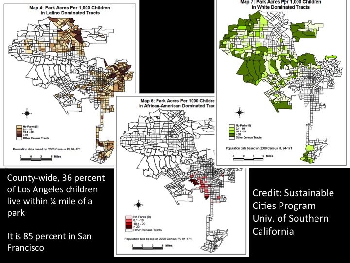
There is similar data in Los Angeles. The Sustainable Cities Program of the University of Southern California reports that, countywide, only 36 percent of Los Angeles children live within ¼ mile of a park. (It is 85 percent in San Francisco.) Worse, the number of park acres per 1,000 children is much higher for census tracts dominated by white families than tracts dominated by African American or Latinos. That is, African-American and Latino children have less access to parks and their benefits.
Matters of access can be even worse in other parts of the world—indeed, there is a crisis of open space in many of the world’s cities. For example, while New York is a relatively dense city—New York has approximately 4m2 of open space per person—Mumbai has much less: people in Bombay have only 1 percent as much open space as New Yorkers. According to Das, much of this results from cozy and non-transparent relationships between developers and cities that don’t serve people.
But this pattern can also be seen as a fundamental question of design and its limitations in planning. We can diagnose the problem and state a goal for change, but what can we do about it? In dense, populous cities, where would you put a new park to create more access? What is the way forward?

Corridors and catchment areas
First, let us acknowledge that access to open space is but one of the justice problems we have with green infrastructure. Nevertheless, let’s focus on this narrow problem. How can we create more access to green and open space in cities that don’t have much space to spare?
Linear parks are an answer, and the principle reason is geometry.
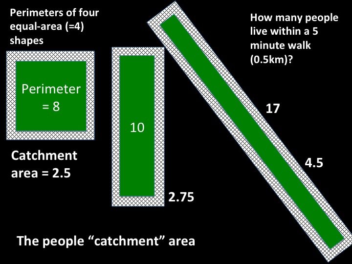
Imagine three hypothetical parks. Each has the same total area—four km2—but they are shaped differently. One is square, the other two progressively more long and thin. Consequently they differ in the total lengths of their perimeters: 8 km around the edge for a square park; 10 km for a rectangular one; 17 km for the thinnest and longest one.
Let’s take the New York standard as a reference: appropriate access is defined as living within a five-minute walk of the park, or approximately 0.5 km. The hatched area in the figure below is the area within 0.5 km of the edge of each park. It is easy to see that long and skinny parks have a much larger area “captured” within 0.5 km of their borders, for the simple reason that they have more perimeter. That larger area represents more people closer to the linear park.
How much more? A hypothetical, square 2km x 2km park comprises a “people catchment area” of about 2.5km within a 0.5km distance of its border; a 0.5km x 8km linear park captures an area of 4.5km. Let’s presume, for a moment, that these three parks are surrounded by the same density of people. The long and skinny park is within a short walk of almost twice as many people.
If how to increase park access is the question, linear parks are a good answer.
Some arithmetic
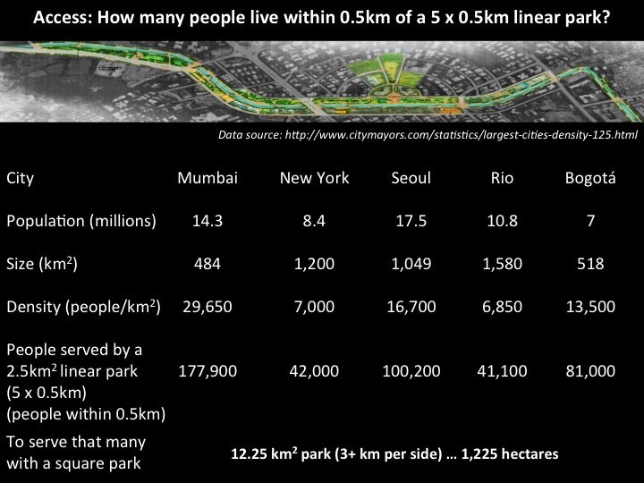
What does this mean for some real cities? The table below includes several cities from around the world, but it is easy to make these calculations for other cities, too. The table uses commonly available data on total population and size to calculate each city’s density (people per km2).
Of course, density is not even across a city, but for argument’s sake, let’s imagine that it is. Further, imagine a linear park within this city: it is 2.5 km2 in area, and it is long and skinny, with a shape of 5 km x 0.5 km.
The people catchment area of this park is the space within 0.5 km of the perimeter. How many people live within this area depends on the density of people around it. How many people live within 0.5 km of such a park in Mumbai (i.e., live within 0.5 km)? Answer: almost 180,000 people (the size of the catchment area multiplied by the density). In Seoul, such a park would serve about 100,000 people. In Bogotá, it is 81,000.
In each of these cities, what is the size of a square park that would serve this many people? Remember, square parks have much smaller perimeters per unit of total size. In each of these cities, a square park of over 3 km per side (i.e., over 12 km2 in total area) would be required to serve the same number of people as the linear park.
Do you have room for a new 3 km x 3 km park in the middle of your city? Probably not.
Linear parks and opportunity
The perimeter to area ratio is why linear parks have great potential to address some of our justice problems with respect to access to ecosystem services: more people are likely to live near a linear park and so be able to enjoy it.
Additionally, linear parks are much more likely to fit within existing cities. In Mumbai, New York, Seoul, Johannesburg, and so on, there are not very many places that large square parks and open spaces could be created—at least, not without displacing a lot of people, which would create its own justice problems. Thus, the opportunities for linear parks are another immensely attractive feature. There are places in existing cities that can accommodate the design of linear parks as part of the natural fabric and topography of the city: along streams (especially day-lighted ones), near roadways, along topographic features, and so on.
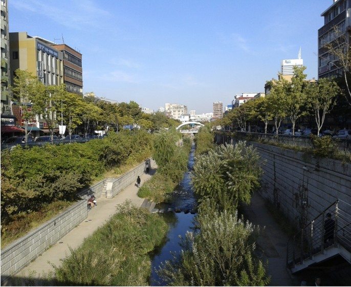
There are many examples of emerging liner parks around the world, and they have considerable potential to increase access of people to open space: the HighLine (New York), the Emerald Necklace (Los Angeles), Cheonggyecheon (Seoul), Jerusalem, P.K. Das’ work in Mumbai, and many others in cities around the world. They are projects of opportunity that have the potential for great rewards in increased access and, therefore, in environmental equity.
Linear parks as panacea
Linear parks don’t work for every purpose, of course. It’s hard to put a ball field in a long and skinny park. In some cases, the edge habitat that dominates skinny parks doesn’t suit certain types of biodiversity or human contemplation. (Although they may promote biodiversity connections between larger green spaces and facilitate other human activities, such as walking and foot-based commuting.) Furthermore, we know that just inserting a green space into previously underserved neighborhoods, however well-intentioned, isn’t always sufficient.
Still, we know that we have a crisis of access to green and open space in many (or most) of the world’s cities. We assert that everyone should have access to the benefits of nature and ecosystem services, from the enjoyment of biodiversity to clean air and protection from storms. As a matter of justice—through the lens of equitable access to the myriad benefits of nature—corridor parks are major opportunities in urban design and planning to improve the lives of millions of people.
David Maddox
New York
About the Writer:
David Maddox
David loves urban spaces and nature. He loves creativity and collaboration. He loves theatre and music. In his life and work he has practiced in all of these as, in various moments, a scientist, a climate change researcher, a land steward, an ecological practitioner, composer, a playwright, a musician, an actor, and a theatre director. David's dad told him once that he needed a back up plan, something to "fall back on". So he bought a tuba.


Its challenging movement especially in developing countries like Tanzania, where Landscape Architecture is still struggling to overcome the bottlenecks around. but we young landscape architects we’re struggling to acquire such mission almost the same with you guys in developed countries.
I’m a little scared with reading this article but yet excited to see an area that gets rarely noticed because non- community residents don’t consider long narrow green space as “real” parks and community residents do and therefore use the park for all different activities. We live in a highly populated condensed urban area on Mosholu Parkway. Our linear park consists of semi landscape enclaves that line the parkway both northbound and southbound from 4 train stop on the Grand Concourse down to Webster Ave. These 14 park malls play a park role to the residents of this community. The openness of the linear park has definitely touched all of us we use it for passive/ aggressive activities, crossing over on paved paths, unpaved paths, on grass, and anywhere that is shortest to the destination. Even the dogs use it everywhere. So how does one protect our green open spaces on linear parks like on Mosholu parkway when we are all using it for everything and anything? The result from everything we do is compacting the soil to a point where the vegetation from foot traffic, large mowers has created slopes where with the run off water has resulted in erosion spreading really bad in some areas. The linear park touches people so much but no one is doing any housekeeping.
Excellent article – I just forwarded it to colleagues with whom I am involved in a research project to develop an ecosystems services evidence base for revegetating railway corridors in Sydney.
Great and clearly explained! Smart planned and maintained linear Parks are definetly a panacea!
I wil discuss your post with my students. Thank you!
Great post!
In addition to the information shared in David’s post from the Washington Post about canopy and income in Washington DC, I was part of a group that did a little work on canopy _change_.
We also found that low income areas had the least amount of canopy, but also lost the most in both area and % area over our study period. Here a link to a short report on canopy change in our Capital: http://caseytrees.org/wp-content/uploads/2015/04/White-Paper-Trees-and-Income.pdf