Changes that cause major disruptions in human settlements, such as those triggered by earthquakes, tsunamis and volcanic eruptions, can give rise to new landscapes that reveal a natural cycle, which is part of the territory where cities grow and develop. These landscapes emerge particularly in cities exposed to recurrent natural disturbances, such as earthquakes, where the natural and human environments are modified. Newer landscapes evolve from geomorphologic, ecological and social changes, and are, at first, usually rejected by the population due to the extent of the disaster. However, over time these new landscapes can be appreciated as they create attractive environments with a strong local identity. This is the case of the city of Valdivia, Chile, where landscapes created after disasters have been safeguarded and properly planned, providing opportunities for human adaptation to disturbances and for the development of life styles integrated with nature, which, in turn, have lead to a more resilient community.
In recent years the study of the characteristics of these landscapes in Valdivia has provided the opportunity to understand how such new environments have been preserved through community and government efforts. These actions have raised awareness and increased education about the dynamics of the environment in which people live. In this manner, the origin of the Valdivian urban landscape has been revealed and linked to the social dynamics that emerged after natural disturbances.

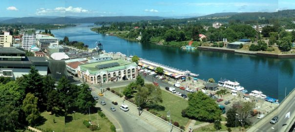
Valdivia is a rapidly growing medium-sized city of 154,097 inhabitants, located in the south of Chile at 39°48’30” S latitude and 73°14’30” W longitude. It has a temperate rainy climate, with rainfall reaching 2310 mm per year; indeed, 16% of its area (1235.8 hectares) is covered by wetlands. The evolution of the urban landscape of Valdivia is, without doubt, a unique case in Chile. The great number of disasters that have hit the city since 1575, have continuously altered the landscape. These include 13 general fires, at least 8 major earthquakes (over 8.0 Mw) and a waterspout that devastated the city in 1881. Human disturbances have been relevant as well, as these have triggered urban expansion processes, continuous land use change and high densification. However, there is an undeniable desire of the community to remain on this site, even though the initial regular grid of the city and its beautiful wetlands, populated by a diversity of birds, wildlife and flora, have been strongly modified over time, particularly after the 1960 earthquake.
The 1960 earthquake (Mw 9.5) is the largest in the history of humankind and in Valdivia it triggered the greatest physical and social changes to date. This earthquake generated processes of large-scale subsidence, landslides on riverbeds and subsequent floods in the city. It also forced the evacuation of the population to the southern outskirts, an area previously occupied by agricultural and natural land, causing a sudden integration between humans and nature. This process created new landscapes that emerged both, immediately after the earthquake and along the past four decades. The process of establishment of Valdivians in these new landscapes shed light on key initiatives on how to live in a changing environment, some of which are described below.
Integrating biodiversity in the city
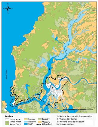
At the time of the earthquake, the edges of the Cruces, Cau Cau and Valdivia rivers, which cross and surround the city, collapsed. The same process occurred in the surrounding arable land, causing significant geomorphologic changes. The land fell between 2 to 3 meters on average, forming new bodies of water, which have now become an integral part of the hydrological network of Valdivia. Following this, the Natural Sanctuary Carlos Anwandter (6.000 hectares) was created in the north of the city in 1981, as the first Ramsar site of the country. This sanctuary is recognized by ecologists for its high biodiversity. Similarly, the Valdivians value it for its recreational appeal, ease of accessibility and as a source of tourism. It is a beautiful landscape with an abundance of Black-necked Swans (Cygnus melancoryphus), Tagua chica (White-winged Coot)(Fulica leucoptera) and Tagua Común (Red-gartered Coot)(Fulica armillata), birds which mostly feed on the luchecillo (Braziliian Waterweed)(Egeria densa), which is predominantly found in the same wetland area.

In the same way, new wetland areas emerged to the south of the city. Although these areas are briefly described in the literature in terms of their biodiversity, they have triggered scholars’ interest because of their effect on society. These wetland areas are highly valued by the community and the municipality, because they provide ecosystem services such as urban beautification, recreation and the regulation of temperatures and flooding.

Safewarding wetland-neighborhoods
Immediately after the earthquake, nearly half the population of Valdivia (30,000 inhabitants) lost their property and were taken to the southern suburbs to settle in temporary shelters arranged by the national government. These were established in the same place where the new wetlands emerged, which provided water and free space. Over time, there has been a strong connection of the community to these places, and even today it is possible to observe how temporary shelters, placed between wetland areas in 1960, have been replaced by permanent houses, keeping the physical relation to wetlands. These houses have evolved into traditional neighborhoods, physically and emotionally rooted into the new urban landscape.
The Huachocopihue and Angachilla neighborhoods, for example, demonstrate a remarkable socio-ecological system. The neighbors have been actively engaged in taking actions to avoid the disappearance of wetlands, which are seen by real state agencies as available land for the construction of new suburbs. Within the last decade, residents have strongly contributed to protect the environment and through have ensured their participation in urban processes of Valdivia in the future. Indeed, the city of Valdivia has a socio-environmental network of 27 organizations engaged in increasing and improving existing interest, capacitates and actions for nature and society. Such a socio-ecological system was achieved by the constant encounter and rediscovery of nature.

Rescuing memories
Another noteworthy event was the spontaneous response of the local community with regard to the imminent flooding of Lake Riñihue into the city. National and international engineers worked together with the community for two months to clear areas of the San Pedro River, because of which the lake was going to overflow and flood the town. Thus, the Valdivian community gathered in an historic process of managing nature, which is recalled today when they outline the urban landscape. Several small local business are named after “The Riñihuazo”, “The Riñihue” and “Earthquake”, among other names, which are shown in large signs outside the stores. These can be described as social earthquake traces, which constantly remind the community about both the catastrophe and opportunities triggered by a natural disturbance.
Creating new interpretation modes
The events mentioned above, among others, have been transformed into the 1960 Earthquake Museum of Valdivia, established in 2010. Besides, in 2013, a 1960 Earthquake Heritage Route was established by the Regional Department of the Ministry of the Environment supported by Trail of Chile Foundation and the Japan International Cooperation Agency (JICA). This route includes places where geomorphologic, ecologic and socio-economic changes can be interpreted.

Usually, the most known changes reported immediately after an earthquake include destroyed buildings, large cracks on the ground and streets covered by debris. Typically a community takes immediate and desperate measures to repair, clear and clean any visual trace, in order to restore normal life and to forget the memories of such a devastating event. The natural and social processes triggered by earthquakes are rarely highlighted, such as has occurred in Valdivia. Whether in a planned or spontaneous manner, and after the earthquake of 1960, new landscapes emerged and have prevailed over time. Their value is immeasurable, as they sustain cultural aspects of historical, ecological and social order, where the community, nature and natural dynamics coexist in an integrated manner.
Thus, it is remarkable how the urban landscapes of Valdivia have turned into a means of interpretation about the dynamics of nature. This highlights the importance of considering ecological and social aspects in urban planning after the disaster, in addition to the reconstruction of buildings only, particularly during the emergency and recovery periods after disaster. It is in these periods, when those aspects are commonly left aside in planning, by focusing the efforts into assisting the general public whose life and habitability is at risk.
However, it is the integrated approach which facilitates the adaptation of the urban dweller to the natural environment, and hence, community resilience. In Valdivia, this integrative approach has facilitated the development of an alternative city, and has successfully responded to challenges that are not commonly considered in urban planning, which in turn has reinforced the interrelations between city and nature.
Paula Villagra
Los Ríos Region, Chile
Links of interest related to this blog:
http://redsocioambientalvaldivia.cl/
http://www.mma.gob.cl/1304/w3-article-55165.html#sthash.lSBrNVqx.EoeBLTPk.dpuf
http://terremoto1960.cl/index.php
http://www.youtube.com/watch?v=2U6vyJQ9xl4
http://www.bosqueurbano.cl/web/index.php/2013-07-28-20-58-15/quienes-somos
http://www.ceachile.cl/Cruces/index.htm
Bibliography list used for this blog and for further reading:
Aldrich, D. (2011). The power of people: social capital’s role in recovery from the 1995 Kobe earthquake. Natural Hazards, 56, 595-611.
Coldinga, J., & Barthela, S. (2013). The potential of ‘Urban Green Commons’ in the resilience building of cities. Ecological Economics, 86(February), 156–166.
Grupo de Trabajo Terremoto (Cartographer). (2010). Plano Ciudad de Valdivia 1961
Guarda, G. (2001). Nueva Historia de Valdivia. Santiago: Ediciones Universidad Católica de Chile.
Guarda, G. (2009). Cuatro Siglos de Evolución Urbana Valdivia 1552-1910. Valdivia: Universidad Austral de Chile.
Hayashi, M. (2010). Water Revives Kobe Communities After the Great Hanshin Awaji Earthquake. Awaji: University of Hyogo, Awaji City, Japan.
Hernández, J. (2010). 1960: Memorias de un desastre Valdivia: Arte Sonoro Austral Ediciones. http://issuu.com/terremoto1960/docs/1960memoriasdeundesastre
Kirschbaum, J., & Sideroff, D. (2005). A Delayed Healing: Understanding the Fragmented Resilience of Gernika. In L. Vale & T. Campanella (Eds.), The Resilient City (pp. 159-180). New York: Oxford University Press.
Muñoz-Pedreros, A., Badilla, A., & Rivas, H. (1993). Evaluación del Paisaje en un Humedal del Sur de Chile: el caso del río Valdivia. Revista Chilena de Historia Natural, 66, 403-417.
Parker, L. H. (1960). La Epopeya del Riñihue. Ercilla: Sociedad Editora Ercilla Limitada, 1308(15 Junio), 16-17.
http://www.ceachile.cl/publicaciones/1993.%20Paisaje%20r%EDo%20Valdivia%20Mu%F1oz%20el%20at.pdf
Pulso Consultores S. A. (2006). Anteproyecto memoria nuevo plan regulador comuna de Valdivia. In Estudio Actualización Plan Regulador Comunal de Valdivia (pp. 1-75. Available at: Santiago: Pulso Consultores S. A. http://www.munivaldivia.cl/regulador/doc/anteproy_memoria.pdf
República de Chile. (1960). Movimientos sísmicos de Mayo de 1960. Labor del gobierno en el período de emergencia. Santiago.
Rojas, C. (2010). Valdivia 1960: entre aguas y escombros. Valdivia: Ediciones Universidad Austral de Chile.
Skewes, J. C., Rehbein, R., & Mancilla, C. (2012). Ciudadanía y sustentabilidad ambiental en la ciudad: la recuperación del humedal Angachilla y la organización local en la Villa Claro de Luna, Valdivia, Chile. EURE, 38(113), 127-145. http://www.scielo.cl/scielo.php?pid=S0250-71612012000100006&script=sci_arttext
Villagra, P. (2012). Landscape change and urban resilience: the role of natural and urban landscapes in earthquake recovery of the city of Valdivia, Chile. Paper presented at the International Conference on Urban Sustainability and Resilience, London. ISSN 2051-1361
Watt, S. F. L., Pyle, D. M., & Mather, T. A. (2009). The influence of great earthquakes on volcanic eruption rate along the Chilean subduction zone. Earth and Planetary Science Letters, 227, 399-407.


2 Comments
Join our conversation