Introduction
Mike Houck
Urban Greenspaces Institute
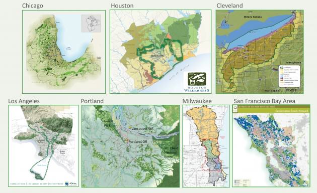
In winter 2009, Houston Wilderness hosted an inaugural meeting of what would become the Metropolitan Greenspace Alliance. Today the Alliance is a national coalition of coalitions working in ecologically, culturally, and economically diverse communities across the US. Alliance members represent Portland, Oregon; Seattle, the San Francisco Bay Area, Los Angeles, Houston, Chicago, Milwaukee, Cleveland, Nashville, St. Louis, Kansas City, Denver, and Baltimore.
Over 80% of the population in the United States now lives within urban megaregions, and this trend of rising urbanization is similar in countries around the world. Amidst significant investments in “grey” infrastructure to support growing metropolitan regions, conserving nature is increasingly challenging. And, more often than not, the most significant challenge is protecting and restoring natural systems that provide clean air and water and other ecosystem services that nature provides us.
Metropolitan regions that effectively incorporate greenspace and Green Infrastructure into their urban fabric share several things in common, often including ample parks and natural areas, both in quantity and equitable distribution; innovative stormwater management; climate adaptation strategies; public transportation and recreational trail networks; and sustainable food production and delivery systems. Whether it’s Vancouver, Reykjavík, Malmö, Portland, or any number of cities around the world that are “green” or in the process of “greening,” the collaboration among governments, nonprofits, scientists, natural resource agencies, and urban planners is essential to transform a place from grey to a green, living, interconnected network of systems that benefit humans and the unique urban ecosystem they inhabit.
The following case study from Metropolitan Greenspace Alliance member Amigos de los Rios describes an almost century-long process of Los Angeles’ greening that should inspire other cities and metropolitan regions toward a greener future. The struggles faced and overcome are not unique to Los Angeles. This story is a glimpse into how universal urban sprawl and development are and the importance of incorporating Green Infrastructure principles into local and regional urban design.
Metropolitan Greenspace Planning in Los Angeles and Beyond
William L. Allen, III, The Conservation Fund
Claire Robinson, Amigos de los Rios
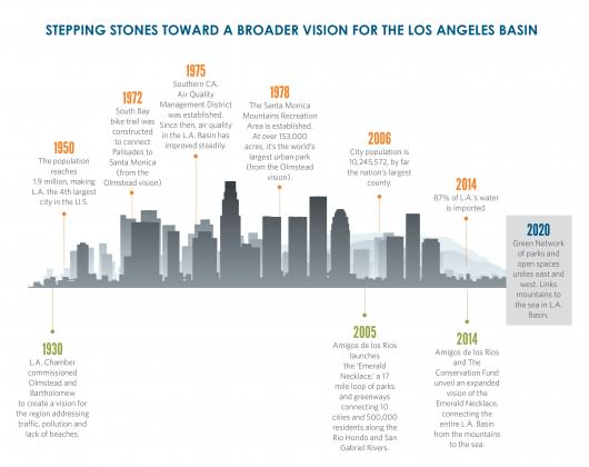
In the late 1920s, the Los Angeles Chamber of Commerce commissioned two highly-regarded landscape architecture firms to create a vision for the region. Leaders became deeply concerned that traffic, air pollution, overpopulation and a lack of access to parks would harm the area’s future.
Two firms—Olmsted Brothers and Harland Bartholomew & Associates—crafted a prescient plan focused on addressing a scarcity of playgrounds and parks, as well as burgeoning traffic, air pollution and a population rapidly swelling to over two million.
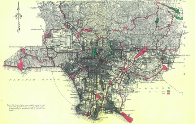
The plan wasn’t adopted, and today these challenges have grown exponentially as the county’s population surges beyond 10 million and the natural landscape is dramatically altered to meet the needs of more residents.
Los Angeles County spans 4,000 square miles and is home to 88 cities and more than 10 million people. Instead of capitalizing on its unique assets of ethnic diversity and picturesque geography, though, the county is cut off from itself. Between mountains and forests to the north and east, and beaches to the west, infrastructure is grey, freeways are gridlocked and quality of life is uneven.
There’s no other place in the United States quite like it; Los Angeles County on its own would be the eighth most populous state in the U.S. and the 88th most populous country in the world. The valley holds nearly one-quarter of California’s population and is one of the most ethnically diverse places in the nation. Its geology is unusual too. Framed by mountains and forests to the north and east, and beaches and oceans to the west, its interior is dominated by grey. Large-scale infrastructure supports a vast population, resplendent with gridlocked freeways, bustling ports, paved riverbeds, and concrete irrigation channels. In the city of Los Angeles alone, average life expectancy differs by 12 years from the lowest-income portion to the highest. Countywide, only 36 percent of children live within one-quarter mile of a park, compared to 85 percent in San Francisco.
The nonprofit Amigos de los Rios decided this could not go on. “We are in the middle of a quiet crisis,” said Claire Robinson, president of the Amigos de los Rios. “We’re not addressing public health, quality of life, and our relationship to nature.” As renowned urban planning writer Jane Jacobs once wrote: “Cities have the capability of providing something for everybody, only because, and only when, they are created by everybody.”
In 2005, Amigos began planning and designing a 17-mile loop of parks and greenways (often underutilized spaces owned by public agencies) along the Río Hondo and San Gabriel Rivers on the east side of Los Angeles that would connect nearly 500,000 residents. The plan’s parks and greenways provide desperately needed recreational areas for communities suffering from extreme density and urban decay, and the associated social and health issues.
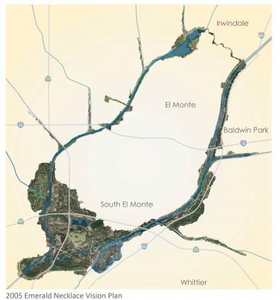
As part of this effort, Amigos has helped convene the Emerald Necklace Coalition, comprised of 62 member agencies with a connection to East Los Angeles. All Emerald Necklace Coalition members have signed the Emerald Necklace Accord, a legal document that pledges its signatories to work collaboratively to preserve and restore the Los Angeles and San Gabriel watersheds and their rivers and tributaries for recreational open space, native habitat restoration, conservation, and education.
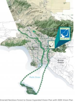
In 2008, the vision was expanded to help unify a vast region of Southern California, from the desert through the San Gabriel Mountains to the Pacific Ocean, by linking more than 1,500 acres of parks and open spaces along an interconnected greenway around the Río Hondo, San Gabriel, and the lower Los Angeles Rivers.
In 2012, Amigos de los Rios commissioned The Conservation Fund to take a fresh look at how to design and use Green Infrastructure to reconnect people and wildlife with the county’s lands and waters. Over the course of 18 months, the Fund worked with Amigos to convene focus groups, synthesize existing plans, analyze mapping data, and evaluate implementation strategies across the county.
The Fund found that despite the significant alteration of the natural landscape over the past century, many of the core recommendations of the Olmsted-Bartholomew Plan are as relevant today as they were in 1930.
The Emerald Necklace Forest to Ocean Expanded Vision plan, released just a few months ago, has created a contemporary vision—calling for a strategically managed and interconnected network of parks, rivers and lands, designed to re-create Los Angeles County as a better place to live, work and play for decades to come. Amigos and The Conservation Fund hope this ambitious expanded vision is a blueprint to unite the county. Rather than starting from scratch, it integrates common elements from existing plans and outlines specific implementation strategies to create a network of parks and public open spaces connected by greenways and trails.
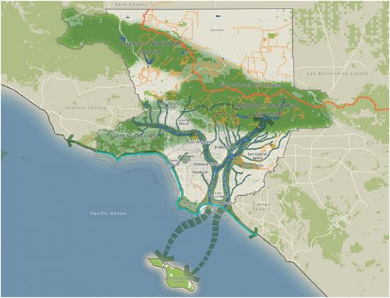
The plan focuses on eight mutually-reinforcing goals under a common vision. In addition to increasing access to a network of equitably distributed transportation—walking, biking and riding trails—it recommends the creation of functional and multi-purpose natural (“green”) and built (“grey”) spaces. The plan addresses the region’s critical water supply, identifying key recommendations to improve how this vital resource is managed to protect local water quality, and assure ample water supply.
The plan prepares communities to be resilient to inevitable effects of climate change, which can be fostered by a community-wide culture that embraces the benefits of conservation, restoration and recreation. Regional wildlife and natural area “anchors” will be enhanced and restored. Finally, the Plan aims for a robust and durable economy where jobs are created that support the multiple benefits of green infrastructure.
Despite the very clear collaborative priorities and strategies outlined in the plan, the key to lasting success will be if the plan is able to instill “a fierce sense of urgency” among the many partners in Los Angeles County that are needed to make this a reality. The plan encourages cities, counties, school districts, water agencies, public health and environmental groups to put a human face to infrastructure and accelerate improvements now for the benefit of Los Angeles County residents and its collective health.
It has been more than 80 years in the making, and it’s the second—and perhaps last—chance to get it right. It will take 20 to 30 years, cost between $200 million and $1 billion, and involve coordination and funding from the region’s 88 cities, private foundations, public bond issues, and public agencies like Caltrans, the US Army Corps of Engineers, Southern California Edison, and the LA Department of Water and Power. “There’s a full awareness that this would be a slog to get a lot of this done,” notes Will Allen, plan lead for the Fund. “There’s a lot of money out there. A lot is convincing people to invest in things that are multiple benefit.”
The City of Los Angeles is on board. Los Angeles Mayor Eric Garcetti said: “The Emerald Necklace Expanded Vision Plan is a visionary framework to link important L.A. area watersheds and the communities they touch. Much in the way that our vision for the L.A. River encompasses its entire 51-mile length, both inside and outside our city limits, the Expanded Vision takes a regional approach to providing much needed open space in some of our most park poor neighborhoods.”
The Emerald Necklace Forest to Ocean Expanded Vision Plan for Los Angeles County, California is available for download here.
William L. Allen, III, Chapel Hill
Claire Robinson, Los Angeles
Mike Houck, Portland
about the writer
Claire Robinson
Claire founded and serves as Managing Director of Amigos de los Rios. Her approach has led to Amigos de los Rios unique success in creating beautifully designed, culturally relevant green infrastructure in open spaces.
about the writer
Mike Houck
Mike Houck, co-founder of TNOC engages urban nature conservation, land use planning, green infrastructure advocacy. He founded the Urban Greenspaces Institute whose motto is “In Livable Cities is Preservation of the Wild” reflecting the belief that without creating livable and loveable cities it will be impossible to protect “pristine” areas outside the city. To be livable and loveable people must have access to nature where they live, work and play. He co-edited Wild in the City, A Guide to Portland’s Natural Areas (2000) and Wild in the City, Exploring The Intertwine (2011) and The Routledge Handbook of Urban Ecology (2011).


Leave a Reply