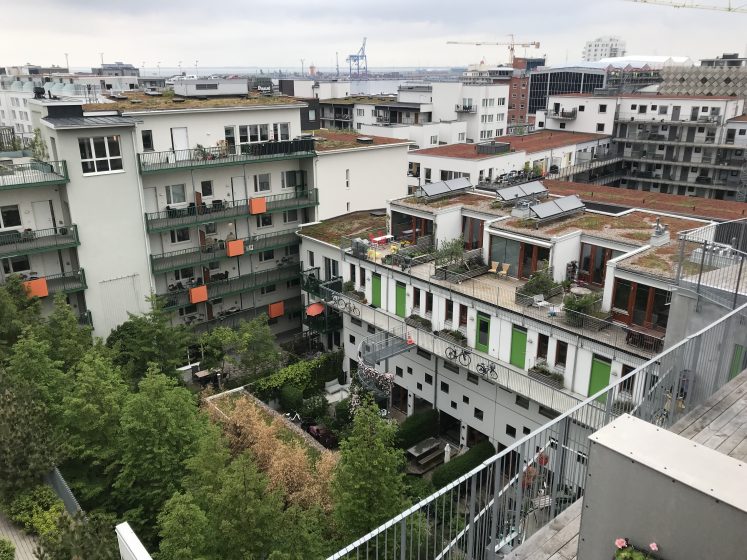
City authorities around the world are looking for policies and tools to facilitate urban greening ― in particular, the process of bringing more soil, vegetation, and water into the built environment through the development planning system. In the UK, authorities are looking at the Urban Greening Factor.
What is it?
City authorities around the world are looking for policies and tools to facilitate urban greening ― in particular, the process of bringing more soil, vegetation, and water into the built environment through the development planning system. In the UK, authorities are looking at the Urban Greening Factor (UGF). UGF has recently been adopted by the City of Swansea in Wales (where it is called the Green Space Factor), and by the Greater London Authority in support of the Urban Greening Policy in the London Plan. This essay looks at how UGF works, its origins, and how it is being used in Swansea and London to boost urban greening.
UGF and the other variants mentioned in this essay are based on Berlin’s Biotope Area Factor. Different landscape cover types in a development plan are assigned scores between 1 and 0, where 1 is natural vegetation and 0 is for completely sealed surfaces. Various categories are given scores according to permeability and naturalness, which acts as a proxy for the various ecosystem services provided. Table 1 lists the various categories used in the London UGF scheme. To calculate an overall score for a scheme, the various landscape cover types are measured and multiplied by their factor score and totalled. This total is then divided by the site area to calculate an overall UGF score. (See Figure 1). Targets of 0.3 are set for commercial developments and 0.4 for residential schemes. Counting of overlapping treatments (for example planting under tree canopies or balconies on tall buildings) is allowed and vertical greening can be measured in elevation, so it is possible to get a score of more than 1.
Table 1. Surface Cover Types and Factors (from the GLA UGF calculator)
| Surface Cover Type | Factor |
| Semi-natural vegetation (e.g., trees, woodland, species-rich grassland) maintained or established on site. | 1 |
| Wetland or open water (semi-natural; not chlorinated) maintained or established on site. | 1 |
| Intensive green roof or vegetation over structure. Substrate minimum settled depth of 150mm. | 0.8 |
| Standard trees planted in connected tree pits with a minimum soil volume equivalent to at least two-thirds of the projected canopy area of the mature tree. | 0.8 |
| Extensive green roof with substrate of minimum settled depth of 80mm (or 60mm beneath vegetation blanket) ― meets the requirements of GRO Code 2014. | 0.7 |
| Flower-rich perennial planting. | 0.7 |
| Rain gardens and other vegetated sustainable drainage elements. | 0.7 |
| Hedges (line of mature shrubs one or two shrubs wide). | 0.6 |
| Standard trees planted in pits with soil volumes less than two thirds of the projected canopy area of the mature tree. | 0.6 |
| Green wall ― modular system or climbers rooted in soil. | 0.6 |
| Groundcover planting. | 0.5 |
| Amenity grassland (species-poor, regularly mown lawn). | 0.4 |
| Extensive green roof of sedum mat or other lightweight systems that do not meet GRO Code 2014. | 0.3 |
| Water features (chlorinated) or unplanted detention basins. | 0.2 |
| Permeable paving. | 0.1 |
| Sealed surfaces (e.g., concrete, asphalt, waterproofing, stone). | 0 |
The diagram and table show a theoretical square development site of 100 sq.m., showing how the site has been analysed in terms of surface cover and areas of each type.

Formula for calculating the overall GSF score
(Score A x Area) + (Score B x Area) + (Score C x Area) + (Score D x Area) etc.
Total Site Area
Depending on how a scheme is operated by an authority, failure to meet the target can result in rejection of a scheme, or an indication that a proposal needs to be amended, to include a larger area of green infrastructure overall, or elements with higher functionality. Cities usually set a minimum score that must be achieved, and some have targets to encourage developers to be more ambitious and innovative, or they may have requirements which relate to the delivery of a specific function or outcome (e.g., stormwater management).
UGF schemes are usually applied to high-density zones or districts where large-scale urban renewal is planned, where rapid development is expected, or where particular problems (including, for example, biodiversity losses, surface water flooding, or deficiency of accessible green space) could be exacerbated by inappropriate development.
UGF schemes are tools to help translate policy objectives into practice. They are used in combination with the full suite of policies that relate to amenity, green infrastructure, and biodiversity and are usually applied in concert with combinations of green infrastructure and biodiversity strategies, district plans, neighbourhood plans, landscape plans, masterplans, and design codes. UGF schemes do not replace policies, strategies, plans or codes, but help planners and designers to understand how designers are interpreting these.
As UGF schemes are part of a response to the problems associated with the increasing density of cities, they are usually applied in locations that tend to be dominated by multi-storey developments. Achieving a satisfactory UGF score in developments with limited or no ground-level greenspace (where a building covers most or all a site) will normally require green roofs. Although tall buildings have the potential for the overall surface area that is greened to be increased, there is also the question of whether target scores should be increased to reflect this potential and to address the higher demands associated with taller buildings. Conventional green infrastructure planning is usually characterised by ground-level emphasis that overlooks the potential to green the roofs, terraces, and facades of buildings. With high-rise developments with green roofs and walls located on multiple levels and aspects it will be increasing important that not only UGF schemes, but all policies related to green infrastructure, biodiversity, and climate change adaptation, take account of the challenges and opportunities and challenges associated with denser developments and taller buildings. (See Singapore’s Skyrise Greenery campaign below).
With increasing building heights and the increasing complexity of building forms, with many terraces, roofs and facades at different levels and aspects, and the importance of understanding the thermal performance of buildings, their influence on microclimate and city-wide phenomena like the urban heat island, researchers are looking at ways of analysing proposals and modifying planning to take account of these factors. Modelling software, including Envi-met and Greenpass, will become increasingly important as climate change increases the number and intensity of heat waves.
Origins
The origins of the UGF, go back to Berlin, which had its Biotop Flächenfaktor or Biotope Area Factor (BAF), that was introduced in 1994, having been explored in the Western Sector of the city in the 1980s. The BAF is applied, in combination with Landscape Plans, in several Berlin’s inner-city neighbourhoods. Landscape Plans address spatial issues and opportunities and the BAF ensures that adequate green space is provided within each development parcel. The BAF works by setting target scores for greening, which are adjusted according to land use, with sites with educational use, for example, requiring the highest scores. Minimum scores for sites within neighbourhoods covered by the scheme vary between 0.3 and 0.6. Problems with surface water flooding and an overall lack of green space were the catalysts for the BAF initiative, and surface cover types are assigned scores that were based on their ability to infiltrate, store, and evaporate water. The BAF is viewed positively by city planners, architects, and developers, who have praised its simplicity and flexibility, however, it is recognised that it cannot be used to assess the environmental impact of a scheme.
A UGF scheme was trialed in 2001 in a new residential development in the post-industrial Western Harbour area of Malmö, Sweden. The original purpose was to ensure that adequate green space was provided on every plot and that sealed surfaces were minimised. A minimum target score of 0.5 was set. The scheme was subsequently revised after the quality of some developments did not match the planning authority’s expectations. A Green Points System was also added to improve the quality of landscape design and to encourage the inclusion of features that increase biodiversity. The scheme is now being applied to a wider area within Malmö as well as the neighbouring town of Lund.

Seattle, in the State of Washington, adopted the Green Factor scheme in 2006, which has been subsequently updated. It was modelled, in some respects, on the Berlin BAF. The three priorities of Seattle’s scheme have been liveability, ecosystem services, and climate change adaptation. As with other schemes, Seattle’s has a catalogue of landscape elements, each with its own score, and a requirement for project proposals to meet a minimum overall score. Minimum scores vary according to zones, with residential zones requiring the highest scores and commercial and industrial areas, lower scores. To qualify for certain scores, landscape features must comply with detailed standards set by the city. For example, bio-retention facilities must include adequate soil volumes. Increased diversity of planting is also encouraged. The scheme includes a provision for bonus credits for drought tolerance, irrigation with harvested rainwater, landscape features visible to passers-by, and food cultivation. For a scheme to be awarded a score, it must be submitted with a landscape plan and landscape management plan and be submitted by a licensed landscape professional. A landscape professional must also verify that the landscape scheme has been installed in conformance with the approved plan. Since the scheme was adopted, Seattle’s Department of Planning and Development has noted higher quality and better-integrated landscape design, with increased use of permeable paving, green roofs, and green walls.
Washington DC operates the Green Area Ratio (GAR) regulation. It was introduced in 2013 and subsequently revised. It has similarities with the Seattle scheme. It has been established by regulation and applies to all applications for building permits for new buildings and major renovations (with a few exemptions). The satisfactory implementation of a landscape scheme, that has met the minimum GAR score, must be demonstrated by a Certified Landscape Expert, before a certificate of occupation may be granted. The scheme gives high scores for trees (measured by canopy size), intensive green roofs, and the conservation of existing soil. Target scores vary according to planning zones, with differentiation between residential, mixed-use, and downtown (city-centre) areas.
Helsinki, Finland, considered a UGF scheme as part of its Climate-Proof City – Tools for Planning (ILKKA) project (2012-2014). The approach was to test the operation of a tool and to use the tool to assess design options in two new development sites (Kuninkaantammi and Jätkäsaari). A unique scoring system was developed by a panel of local experts. Issues considered were ecology, functionality, amenity, and maintenance, with the ecological and functional goals prioritised over amenity and maintenance. Minimum scores were set for various land use classes, including residential (0.5), office (0.4), commercial (0.3), and industrial/logistics (0.2), with an expectation that higher targets would be met. These targets reflect the typical differences in the extent of greenspace provided within these development types in Helsinki.
Singapore, which has promoted the ‘City in a Garden’ vision, has explored a Green Plot Ratio (GnPR), which measures overall leaf area and compares this with site area. Typical leaf area indices for trees, palms, shrubs, and grasses are used in the calculations and it is intended that the GnPR approach will assist in evaluating green infrastructure on tall buildings. Singapore has also been at the forefront of promoting green roofs and green walls on tall buildings through its Skyrise Greenery scheme of incentives and awards.
UK Initiatives
Using a UGF tool is a requirement for applications within Southampton’s City Centre Action Plan (AP 12), which in 2015, “required all developments (and especially key sites) to assess the potential of the site for appropriate green infrastructure improvements by using the Council’s Green Space Factor, and to improve the score for the site.” For other sites not within the City Centre, the council encourages, but does not require, use of the tool. Scores are assigned according to the rate of infiltration of rainwater for each landscape element. The scoring system considers existing land cover, encourages retention of existing features, and requires an overall increase in score compared with the existing condition. Performance requirements for surface cover types are not prescribed (as they are in the US for example). A completed spreadsheet is submitted as part of an application; however, there is no requirement for a suitably qualified professional to do this and no mechanism for verifying that a scheme has been implemented satisfactorily.
Swansea introduced the Green Space Factor in 2021, as part of its city centre green infrastructure strategy. Swansea’s GSF is based on London’s UGF (see below). In Wales, sustainable drainage (SuDS) for new development is a requirement and local authorities act as SuDS approving bodies (SABs). Having SuDS on its own does not always result in the best multifunctional outcome, with engineers opting for tanks instead of nature-based solutions, however, the GSF highlights the importance of high-quality green infrastructure in new projects. This has already led to several urban renewal proposals, featuring green roofs and green walls in Swansea City Centre. An example is the Biophilic Living housing and office project in the High Street. A culture is being created whereby there is an expectation that all new buildings will feature a green roof.
The New London Plan was adopted in 2021 and features the Urban Greening Factor (UGF) as a tool to boost urban greening in new development. In anticipation of the formal adoption of the UGF, local planning authorities in London have been asking for developers to submit UGF calculations for schemes for some time. An example is the City of London Corporation, where there is a cluster of high-rise buildings which will need vertical greening to meet UGF targets. Inner London boroughs are preparing their own version of the UGF ― see for example the London Borough of Southwark. And the London Legacy Development Corporation (LLDC) in east London centred on the Queen Elizabeth Olympic Park. Examination of planning applications in that borough show how developers are squeezing green space onto buildings to meet the 0.4 UGF target (Figure 2 shows a controversial high-density scheme in Ilderton Road to illustrate this point).

Conclusions
In those cities where they have been adopted, UGF schemes have been shown to increase the amount of green space within developments, as well as increasing functionality, particularly with respect to surface water drainage. Depending on how they are operated, UGF schemes may also have the aim of requiring, or encouraging, more developers to take specialist advice (usually from landscape architects) to ensure that their plans meet the planning authority’s requirements. With most UGF schemes, the purpose is easily explained and understood and the calculation of the overall score is a relatively straightforward and inexpensive process. Schemes allow flexibility with respect to plot layout and landscape design and are not prescriptive. Scores for particularly desirable features can be increased to encourage use.
The benefits of UGF schemes include,
- A reported increase in the use of multifunctional green infrastructure features
- More greening on restricted sites in densely developed areas
- A simple mechanism easily understood by non-specialists
- Facilitation of conversations between developers and planners
- Empowerment of local authorities, who may successfully argue the case for more greening
- Flexibility: scores and targets can be adjusted to reflect local priorities
UGF schemes may be perceived as an unnecessary additional administrative burden. This is more likely to be the case in cities, like those in the United States, for example, where the attainment of a score is a pre-requisite of the permitting process. It has been suggested that fragile landscape features (like intensive green walls for example) could be included in plans for meeting a target, with those features subsequently failing if not properly installed or maintained. It should be noted that artificially engineered features tend to require more maintenance and are more vulnerable to failure than retained existing features or more traditional planting in natural soils.
Although scoring schemes are relatively simple, the score assigned to any surface cover may vary from city to city and the assignment of a score to a landscape treatment can be subject to debate. There is the potential for low-quality features (for example green roofs with inadequate substrate depth) to be used to promote and build unsatisfactory schemes that meet the target score. These difficulties can be overcome by providing good definitions and accurate descriptions of the various types of surface cover. If necessary, scoring schemes can be reviewed to address persistent shortcomings.
Potential issues (depending on how a UGF is implemented) can include the following:
- given that a UGF determines only the quantum of broadly described categories, the design quality of each treatment cannot be assessed in detail.
- there is a possibility of the UGF scheme being too rigidly interpreted, with proposals meeting, but not exceeding targets (a compliance mentality)
- Not promoting green roof and green walls could result in insufficient green infrastructure being created in schemes with tall buildings and a small ground-level curtilage.
Considering these issues, it will be essential to be clear and precise about how a UGF scheme relates to the full suite of policies that influence greenspace planning and design. Planning authorities will need to make clear that the UGF will be an assessment tool and will not be the sole method of assessing GI proposed as part of a development scheme. Planning tools cannot be a replacement for good design. UGF needs to be promoted as a tool to complement and help deliver policies and standards on, urban greening, well-being, biodiversity, and climate change adaptation, including summer cooling and sustainable drainage.
Gary Grant
London


Leave a Reply