Historically, North American urban environmental and natural resource management was operationalized in a top-down, command-and-control fashion. In general, governments prepared plans and made decisions with some limited input from other stakeholders. Over time, this shifted to a more bottom-up, collaborative approach ― an ecosystem approach. The ecosystem approach is not new but needs to be re-energized, particularly in urban areas, to realize greater benefits for more stakeholders and to foster cooperative learning and sustainability.
Ecosystem approach
An ecosystem approach accounts for the interrelationships among air, water, land, and all living things, including humans, and involves all user groups in comprehensive management. It uses systems thinking to better understand and manage ecosystems. Ecosystem approaches are frequently designed for a particular place and a particular set of stakeholders. As such, they are frequently referred to as locally designed ecosystem approaches.
An ecosystem approach is both a way of thinking and a way of acting. For example, the difference between the environment and the ecosystem is like the difference between a house and a home. House is something that is viewed as external and detached and home is something we see ourselves in even when not there. What we do to our ecosystem we do to ourselves.
Fostering an ecosystem approach can be challenging because of the transactional costs (the amount of time and meetings required), scientific uncertainty, limited predictive capability, and complexity of spanning political, disciplinary, and institutional boundaries. In the Great Lakes Basin, the use of an ecosystem approach has helped focus on integrated resource assessment and management and helped transcend jurisdictional boundaries and focus on watersheds. Commitment to involving all user groups in management has led to participatory governance and thinking beyond boundaries. Key elements of an ecosystem approach include: bringing stakeholders together; defining a desired future state or vision that can be carried in the hearts and minds of all stakeholders; building capacity through fostering cooperative learning, strengthening science-policy-management linkages, and ensuring human and financial resource support; co-producing knowledge; co-innovating solutions; and practicing adaptive management where assessments are made, priorities established, and actions taken in an iterative fashion for continuous improvement.
An ecosystem approach and ecosystem-based management now have a 50-year history of understanding ecosystems and managing relationships between humans and their ecosystems. Three good Great Lakes urban examples of where an ecosystem approach has been successfully applied are presented below.
Don River naturalization in Toronto, Ontario, Canada
The Don River is located in the heart of the six-million-person Toronto metropolitan area. It is a 24-mile river that stretches from its headwaters on the Oak Ridges Moraine to the Keating Channel where it empties into Lake Ontario. As the city region grew and became more urbanized in order to provide for its expanding population, environmental pollution increased, with no better example than the Don River.
Over time the Don River (also called the Don) was straightened for convenience, channelized, paved, and built over, and polluted with substantial municipal and industrial waste and land runoff to the point that it twice caught on fire. A 1958 Toronto Globe and Mail editorial noted that the Don had “waters heavily polluted and laden with scum, its banks littered with all varieties of filth, and the whole sending up foul odors”.
Few people thought that the Don could ever be brought back to life. But after years of planning, the federal, provincial, and municipal governments announced in 2017 a $1.25 billion CAN project, called the Don Mouth Naturalization and Port Lands Flood Protection Project, to bring back the Don and restore the east waterfront.
This project is literally constructing a new naturalized river mouth through the Port Lands and creating a new urban island neighborhood called Villiers Island. In addition, it will provide critical flood protection to 593 acres of Toronto’s eastern waterfront. It must be recognized that much of this area along Lower Don was filled during the 1800s, and as a result, many of the historical ecosystem services or benefits were lost, including buffering against flooding, providing habitats for fish and wildlife, filtering stormwater, protecting shorelines from erosion, and supporting recreation.
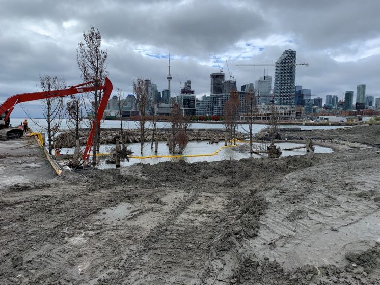
The river valley will also add 40 acres (16 ha) of new parkland, promenades, and riverfront open space. It will create 36 acres (14.5 ha) of new aquatic habitat and wetlands to improve biodiversity and water quality and naturally moderate the effects of flooding and erosion. It also addresses legacy pollution by remediating contaminated soils and sediments through a combination of removal of some contaminated sediments, capping others, and bioremediation ― using microorganisms to degrade organic contaminants and make some less toxic. In addition to the above environmental benefits, construction will generate approximately $1.1 billion CAD in value to the Canadian economy, 10,829 person-years of employment, and $373 million CAD in tax revenues to all levels of government.
This project is projected to be completed in 2024. It is a strategic move to restore ecosystem health to the Don, help reconnect people with it, and help make nature part of everyday urban life. It has already won many awards, including the Best Overall Project at the 2021 Canadian Brownfield Network Brownie Awards.
Key strengths of the process include stakeholder engagement and 30 years of citizen advocacy to bring back the Don, co-production of knowledge, co-innovation of solutions, and provision of social, economic, and environmental benefits.
Detroit RiverWalk in Detroit, Michigan, USA
Detroit was widely recognized as the “Arsenal of Democracy” during World War II, is the automobile capital of the United States, and is often considered part of the Rust Belt. During the 1960s, the Detroit River was considered one of the most polluted rivers in the United States. Oil pollution was causing winter waterfowl kills, phosphorus pollution was causing accelerated eutrophication, municipalities and industries were causing violations of water quality standards, toxic substances in fish were a major threat to human health, and land use practices had destroyed wetlands.
Like many other large North American cities, the Motor City made the river its back door, with businesses facing inland and away from the river. Compounding the problem, Detroit became indifferent to the water pollution that was perceived as just part of the cost of doing business. As a result, Detroit residents lost connection to their river.
Cleanup of the Detroit River over the last more than 40 years has resulted in measurable improvement in water quality and surprising ecological revival, with a return of bald eagles, peregrine falcons, osprey, lake sturgeon, lake whitefish, walleye, beaver, and even river otter. Although much has been accomplished, much remains to be done to restore the physical, chemical, and biological integrity of this ecosystem.
Out of the growing public interest to improve public access to the Detroit River and improve non-motorized transportation options like bicycling, and strong public and private support to revitalize Detroit, the Detroit Riverfront Conservancy was created in 2003 to transform Detroit’s international riverfront ― the face of the city ― into a beautiful, exciting, safe, accessible world-class gathering place for all called the Detroit RiverWalk. Today, it has been identified by USA Today as the No. 1 riverwalk in the United States. Economic benefits of the Riverwalk totaled over $US 1 billion for the first ten years alone and more than three million annual visitors are using it.
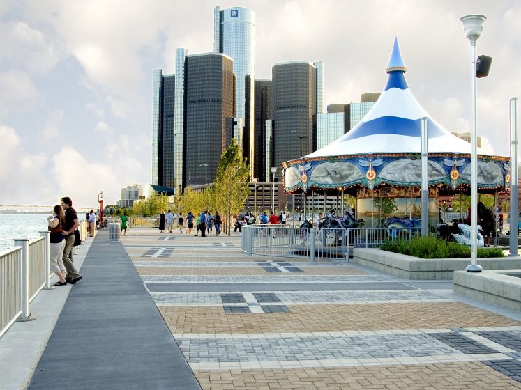
The Conservancy is a public-private partnership that has functioned as a boundary-spanning organization, bringing stakeholders together, co-producing knowledge, co-innovating solutions, practicing adaptive management, and realizing benefits to all. Its community engagement has been exemplary, reaching down to block clubs, churches, and community groups through listening sessions and design charettes. It has worked through partnerships to clean up industrial brownfields, restore shoreline habitats in eight locations, and clean up contaminated sediments in two locations while building a world-class gathering place for all.
Hamilton Harbour’s Randle Reef in Hamilton, Ontario, Canada
Hamilton Harbour is a 5,313-acre (2,150 ha) embayment located at the western end of Lake Ontario. Hamilton, Ontario is a port city located on the banks of the harbor. It has over a 100-year history of steel making, resulting in it being named the “Steel Capital of Canada”. This long history of industrial and urban development resulted in substantial pollution of the harbor.
Stakeholders in the greater Hamilton region have a long history of advocacy for cleaning up harbor pollution. The major coordinated effort started in 1985 when the Hamilton Harbour Stakeholder Group came together to develop and implement the Hamilton Harbour Remedial Action Plan. Over time, the governance structure evolved into a Bay Area Implementation Team (that includes all the agencies and organizations responsible for the implementation of cleanup and restoration) and the Bay Area Restoration Council (an independent incorporated citizens group responsible for monitoring remedial progress and charged with education and advocacy). Together, these two organizations are equal partners in restoring Hamilton Harbour as a thriving, healthy, and accessible Great Lakes ecosystem.
One of the legacies of over 100 years of industrial production was considerable contamination of harbor sediments, the most significant being near Randle Reef. The Randle Reef is approximately 148 acres in size and contains more than 90,700 cubic yards of contaminated sediment at the bottom of the harbor, a volume that would fill a major hockey arena three times over.
Local stakeholders took this issue on, and today Randle Reef is the largest contaminated sediment remediation project in the Canadian Great Lakes. Its cost is $139 million CAN. The Government of Canada and the Province of Ontario have each committed $46.3 million CAN, with the final third coming from the City of Hamilton, City of Burlington, Regional Municipality of Halton, Hamilton-Oshawa Port Authority, and Stelco (formerly U.S. Steel Canada).
This project involves constructing an engineered containment facility that is specially designed as a 15.3-acre double steel-walled and sealed “box” to contain the most heavily contaminated sediment. Environment and Climate Change Canada is leading this effort.
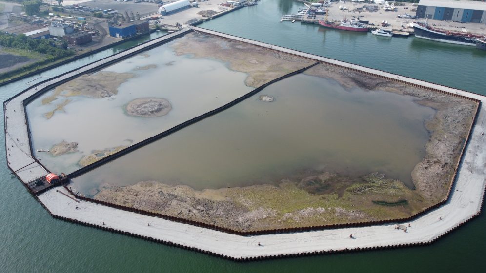
This entails constructing the containment facility in the harbor, filling it with the contaminated sediment, placing an impermeable cap on the sediments, and then turning it over to the port authority to expand its operations. This project began in 2015 and is now projected to be completed in 2025, due to delays resulting from the covid pandemic.
The final uses of the facility will provide social and economic benefits to the local community and project stakeholders. Economic benefits are projected to be $96 million CAN to local property owners, $38 million CAN to local businesses, and $29 million CAN to municipal governments. The project will also provide short-term employment opportunities in the local area during the construction and long-term operation of the facility.
The cleanup of Hamilton Harbour is an integral and essential part of the region’s revitalization strategy. The vision is for Hamilton Harbour to be a vibrant centerpiece in the community by improving the potential for recreational uses while maintaining its essential economic function.
The Hamilton Harbor cleanup effort and its Randle Reef contaminated sediment remediation project are considered exemplars of the use of an ecosystem approach. Bay Area Restoration Council and Bay Area Implementation Team have functioned as boundary-spanners, bringing stakeholders together, co-producing knowledge, co-innovating solutions, practicing adaptive management, and realizing social and economic benefits.
Education, cooperative learning, capacity building, co-production of knowledge, and co-innovation of solutions have all been essential to make better use of an ecosystem approach in achieving urban ecosystem sustainability. Based on experience from the Great Lakes Basin, it would be prudent to prioritize the development of boundary spanners ― individuals who establish “bridges” within and outside an organization who can help serve as facilitators, knowledge brokers, and champions of strengthening science-policy-management linkages.
John H. Hartig
Windsor






Add a Comment
Join our conversation