The Loneliness of the Protected Area: Biocultural Connectivity, Social Media, and Living in Harmony with Nature

Art, Science, Action: Green Cities Re-imagined
Just as building real connections with people cannot be achieved quickly using technological shortcuts but rather requires time and effort over the long term, building the landscape elements that create biocultural connectivity is also a slow process.
On social media and connectivity

Like a lot of people, my new year’s resolution last year was to stop spending so much time on Facebook and other social media. And like probably a lot of people, I completely failed. So this year, I made a different resolution. This year I resolved to spend more time on social media.

To clarify, I resolved to keep using social media but to make active efforts to post things and be more engaged. I realized I had become a social media lurker, spending hours scrolling through Facebook or Twitter feeds, but hardly ever posting anything myself. My notification areas were empty. Social media and all our modern tech is supposed to connect us, but for all the time spent online, I was making very few actual connections to other people.

Photo: kropekk_pl (Pixabay, Public Domain)

Studies from the past few years indicate that this is a trend. Although people are superficially more connected than ever before, many of us still feel more lonely. In fact, there were a number of stories a few years ago about an “epidemic” of loneliness among teenagers in the UK, where the government recently appointed a “minister of loneliness”. So I’m trying to post something I find interesting on Facebook every day, and use its platform as a way to actually communicate with other people.

I am writing about this for TNOC as a way to make my resolution part of the public record, increasing my chances of keeping it, and also because it is relevant to the nature of cities as an analogy for what I see happening related to connectivity in fields like biodiversity conservation, sustainable development, and others that we read about here. I have been writing on TNOC for a few years about biocultural diversity, particularly discussing biocultural connectivity, and these topics seem particularly relevant to what is happening today. In short, some of the very institutions that have been created to enhance connectivity—both interpersonal and environmental—are having exactly the opposite effect.

First, a little background including some recent developments. In Convention on Biological Diversity (CBD) processes, we are approaching the end of the timeframe for the Strategic Plan for Biodiversity 2011-2020, which coincides with the UN Decade on Biodiversity. The Aichi Biodiversity Targets are the heart of the Strategic Plan, consisting of 20 targets of varying scope and specificity, supposedly to be achieved during the Decade (although, as we will see below, some of them are conceived as aspirational targets and cannot reasonably be expected to be achieved within one or even several decades). The timeframe for these targets is therefore coming to a head as Parties to the CBD consider what progress has been made, which targets are and are not likely to be met, the process of how the targets were produced, and what lessons can be learned for what comes after 2020. Mention has already been made in CBD negotiations of a “post-2020 global biodiversity framework”, and it is expected that a new set of targets will be adopted at the CBD’s fifteenth meeting of the Conference of the Parties (CBD COP 15) in China in 2020.

Within the context of the Aichi Targets, connectivity is most explicitly mentioned in relation to Target 11, which says “By 2020, at least 17 per cent of terrestrial and inland water areas and 10 per cent of coastal and marine areas, especially areas of particular importance for biodiversity and ecosystem services, are conserved through effectively and equitably managed, ecologically representative and well-connected systems of protected areas and other effective area-based conservation measures, and integrated into the wider landscape and seascape”. This is usually thought of as the target on protected areas, but—in a reflection of the difficult negotiation process that produced the Strategic Plan—a lot of different ideas got tossed into the word salad that is this target, so it could also be about concepts like “equitably managed”, “integrated”, and “well connected”. But generally speaking, connectivity shows up in CBD contexts essentially as a function of protected areas management.
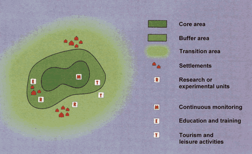
One view of protected area integration into the wider landscape, from UNESCO’s Man and Biosphere program. Image: Diagram taken from the booklet, “Octavius on Biosphere Reserves” published by MAB France, © Octavius, MAB France

Pitfalls of quantifiable targets

Target 11 is unusual among the Aichi Targets because it is one of the few that includes measurable numbers for parties to aim for, by specifying 17 percent for terrestrial and inland water areas and 10 percent of costal and marine areas to be somehow protected. Other targets are vague about requirements to be met, for example, Target 7: “By 2020, areas under agriculture, aquaculture and forestry are managed sustainably, ensuring conservation of biodiversity”. What is meant by “areas” in this context? All agricultural land, or just some of it? This—similar to Target 1: “By 2020, at the latest, people are aware of the values of biodiversity and the steps they can take to conserve and use it sustainably” among others—is an example of an aspirational target, unlikely to be met within the UN Decade on Biodiversity.

The pitfall here is that because Target 11 includes quantitative goals, countries can positively evaluate their progress in achieving it, by counting hectares of protected areas or kilometers of protected coastlines. But in doing so, uncountable concepts like integration and connectivity get lost. After all, it is a relatively simple matter to count protected areas, but not to quantify whether they are ecologically representative, well-connected and integrated into the wider landscape. This is one reason why a major survey like the Global Biodiversity Outlook 4 indicates that despite protected area coverage growing globally and likely to meet the target, the status of biodiversity continues to decline.

There are, therefore, two lessons that we should hope CBD negotiating parties will take from the experience of Aichi Target 11 as they look toward creating the next set of targets for the post-2020 global biodiversity framework. One is putting too many elements into one target results in a lack of focus and confusion about the actual goal of the target. The other is that targets must be consistent in identifying quantifiable goals or not. Otherwise, parties will find it easier to focus on quantifiable targets, to the detriment of all of the other targets and important concepts like connectivity.

In case you needed another acronym to remember, meet “OECMs”
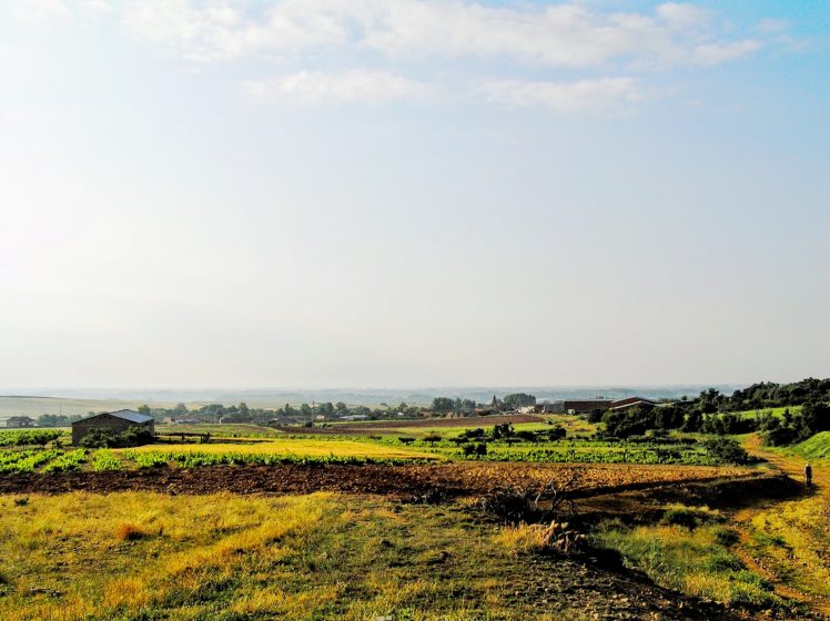
An integrated socio-ecological production landscape in Spain. Photo: William Dunbar

An ongoing effort to address some of the concepts included in Target 11 is work by IUCN and partners developing “guidelines for recognising and reporting other effective area-based conservation measures” (OECMs). OECMs were included in Target 11 in an attempt to address some of the very problems identified here by making sure that it is not simply a matter of creating official protected areas, but also recognizing that many different types of land-uses can benefit biodiversity, from indigenous-controlled lands to Globally Important Agricultural Heritage Systems (GIAHS) recognized by the Food and Agriculture Organization (FAO) or “socio-ecological production landscapes and seascapes” promoted in the Satoyama Initiative.

Unfortunately, the lessons suggested above seem not to have been learned in developing these guidelines, which define OECMs as distinct, clearly defined areas set aside for biodiversity conservation. In other words, these are protected areas in every way other than legal recognition as such. This approach results in the same problems we see in protected areas, namely that they are so specific and narrowly-defined that they cannot be integrated parts of a “well-connected system” as prescribed in the target. This represents a real missed opportunity since the idea of OECMs is well-suited to embrace connectivity and integration into the landscape if areas like buffer zones and biocultural corridors were included. The guidelines as they currently exist are more likely to only apply to a small number of isolated pockets of biodiversity, and provide no motivation for integration or connectivity. It can only be hoped that these issues will be dealt with somehow in future planning.

At the beginning of this essay, I described how communications technology available to each individual person in modern society has gotten much greater, but a lack of real connection between these individuals shows that this technology is not achieving its intended purpose due to a lack of real, robust connectivity. I hope the analogy has become clear to the continuing tendency towards creating protected areas, and now OECMs, as isolated pockets that each may contain great biodiversity but are not achieving the intended goal of improvements to the biodiversity situation. In both cases, it is a lack of connectivity that prevents these instruments from fulfilling their purpose.

Slow progress on biocultural connectivity

For Target 11 to be fully effective, protected areas need to be integrated into landscapes where much more land area is used for human production activities. I would like to stress that the connectivity needed in wider-scale landscape planning is exactly what we call biocultural connectivity, and this can only be achieved with biocultural diversity. Toward this effort, there are some recent developments in the field of biocultural diversity that I wrote about in an earlier essay, following up on the process of creating an “Ishikawa-Kanazawa model” for biocultural diversity in cities, partly led by the government of Kanazawa, Japan.

In 2016, Kanazawa went on to hold the 1st Asian Conference on Biocultural Diversity, where the “2016 Ishikawa Declaration on Biocultural Diversity” was adopted, inviting party governments to support work towards biocultural diversity on a wider scale. The CBD Secretariat and UNESCO’s Joint Programme on Links between Biological and Cultural Diversity and its partners are working to organize “Dialogues for Collaborative Action on the Links Between Biological and Cultural Diversity”, including a number of “action groups” that will discuss various aspects of biocultural diversity to present at CBD COP 14 and 15. The first of these action groups will be “The Action Group on Knowledge Systems and Indicators of Wellbeing”, meeting in April in New York.
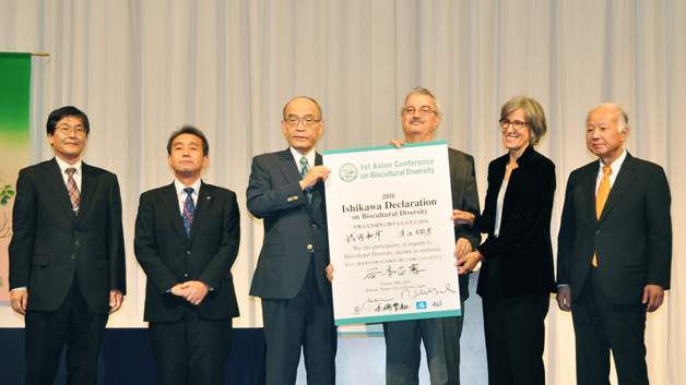
Signatories to the 2016 Ishikawa Declaration on Biocultural Diversity. Photo: UNU-IAS OUIK

My own project’s “Indicators of Resilience in Socio-ecological Production Landscapes and Seascapes” are expected to be among materials on indicators presented for the action group’s “cross-cutting exploration of knowledge systems and indicators of wellbeing”. The set of indicators developed in this project attempts to identify elements that suggest whether a landscape or seascape and its resident communities are resilient. It is clear that many of these indicators are biocultural elements, such as “households and/or community groups maintain a diversity of local crop varieties and animal breeds” and “local knowledge and cultural traditions related to biodiversity are transmitted from elders and parents to young people in the community”. This is to say that, to some degree, what makes a landscape resilient is what makes it biocultural.

There is another way the analogy of modern technology failing to connect us as humans and the lack of connectivity in the landscape works. Just as it is relatively quick and easy to create protected areas—still often difficult, but easier than fostering true biocultural connectivity—in order to fulfill quantitative biodiversity goals like Aichi Target 11, sending messages through modern technology is also easy and fast as the speed of light. But again, just as building real connections with people apparently cannot be achieved quickly using technological shortcuts but rather requires time and effort over the long term, building the landscape elements that create biocultural connectivity is also a slow process.

Socio-ecological production landscapes and seascapes in places around the world have been created through a slow process of people interacting with nature over hundreds or thousands of years. Rebuilding them where they have become degraded will likewise take years of work and smart management to restore their biocultural connectivity. In much the same way, the often-frustrating negotiations in international processes like the CBD, and the process of arriving at a truly effective global biodiversity framework, can be slow and not immediately gratifying. Perhaps we should not be overly afraid of slow progress, and trust that the very process of undergoing these negotiations is itself a kind of connectivity-building, just as continuously working the land can result in harmonious connections between humans and nature.

Going back to my analogy for how this biocultural connectivity relates to interpersonal connectivity via social media, so far, my new year’s resolution to post daily on Facebook has not resulted in any immediately satisfying improvement in connectivity, although I have mostly stuck to it. But in a small way, I am already having a few more interactions with friends on the site every day, finding common interests, or just joking about a silly picture. These little interactions provide a few more things that my friends and I have in common, gradually forming a little more solid basis to our relationships. Turning social media technology into something worthwhile is a slow process of making connections, and making connections is itself what builds connectivity. Similarly, producing the post-2020 global biodiversity framework will be done in a flurry of policymaking and negotiations over the next few years, but achieving the real goals of a world where people live in harmony with nature is going to be long-term and slow, and only achieved by doing the hard work to build many different forms of connectivity.

William Dunbar
Tokyo

On The Nature of Cities

Rethinking Cities as Vulnerable Ecosystems

Art, Science, Action: Green Cities Re-imagined
New long-term development plans that do not integrate management of potential future climate conditions will put many people in harm’s way. The task is nothing short of a complete overhaul in planning practice, and a deep integration of fields that are historically divided.
Cities are dynamic complex adaptive systems. They are a network of systems interacting and exchanging flows of energy, information, and materials, held together by a set of rules, based on millennia of ecological change and more recent governance structures. Dominant narratives and practices describe cities as human systems that are separate from regional (or rural) ecosystems. After all, cities can defy gravity and pool natural resources unlike any other ecosystem on the planet. As a result, many city practitioners view the built environment in isolation from the regional ecosystems, and the resulting development patterns and processes presume that the infrastructure, communities, and systems can withstand extreme events, including floods, fires, and heat waves.

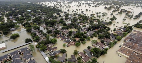
However, climate change is now testing these assumptions by shifting local weather toward the unexpected, revealing a gap in what cities can withstand and the type, number, and magnitude of extreme weather events they will experience. The impact from hurricanes Harvey, Irma, and Maria, offer a sobering perspective on how the more predictable patterns of extreme weather events are changing, and how cities are indeed not isolated and that the built environment is highly vulnerable to impacts. Harvey and other events like it are occurring at a scale that we are currently unable to withstand or support. Climate models and scientists suggest that these extreme events are only the beginning of the shift we can expect for decades to come.

City planners are on the front lines of climate change adaptation, and their ability to implement effective changes, from policy and regulation to infrastructure and technology, will determine their city’s capacity to cope with the next big storm. Recent disasters are forcing an examination of how urban preparation, response, and recovery mechanisms require a redefining of cities as vulnerable ecosystems.

The task that city planners face is immense, and timing is critical because while we do not know exactly what or where, extreme weather is unavoidable, and will hit in unexpected places in unpredictable ways. With such immense uncertainty, planners and urban researchers must identify adaptation measures with the latest, yet incomplete understandings. These adaptations, many of which are still emerging, require however, recognition that cities are not monolithic, safe, and robust environments, and in fact may be the opposite. They are indeed vulnerable because they are places where social, technological, and biological components come together to impact human capacity to survive, particularly during extreme weather events.

Indeed, recent extreme events can be seen as justification for better integrating the functions of city offices—e.g., planning, transportation, parks, and emergency management—to couple changing social conditions, aging infrastructure, and advancing technology with the impacts of climate change. The processes that determine the prioritization and allocation of urban adaptation projects, i.e., protecting the historic downtown vs. a working-class community, partially determine who is likely to suffer most in extreme events. For example, why was there no city-assisted evacuation plan in place for the neighborhoods that were most impacted by Katrinai? How did the chemical plant explosions from Harvey impact those with the least access to or control over resources? These behind the scenes processes are often subtle and manifest institutionalized yet invisible processes of inequality such as bias, racism, and privilege though their outcomes.

To uncover some of these inconspicuous dimensions of prioritization processes for urban adaptation to climate extremes, we interviewed planners in five cities across the United States—Baltimore, Miami Beach, Portland (Oregon), Syracuse, and Phoenix—to identify the mechanisms that recreate, and potentially amplify social inequities. We wanted to know in detail why a particular event was impactful on the capacity of cities to withstand extreme weather events, and how current decision-making processes are interacting with the subtler forms of privilege that occur in city planning and politics. Although this research is in its early stages, we highlight a few key findings, which may help to shed light on preparation for the future extreme events.

The urban context matters

The complex development history of cities and the legacies inherited by residents and planners offer insights about the conditions that hamper urban climate adaptation efforts. These are, of course, unique circumstances for each city, consisting of powerful (empowered) individuals, institutions, and networks that lock-in development trajectories. For example, the development of Baltimore is facing entirely different issues than Miami Beach, and factors that go beyond biophysical and locational differences. While Baltimore was shaped by legacies of policy-supported racial segregation, Miami Beach arose as a tourism resort community, which arguably amplifies economic segregation between the new arrivals and those early European settlers. The heat vulnerability differential in Phoenix, where neighborhoods just two miles apart can experience a 13-degree temperature difference, can be partially explained by how the city grew and where immigrant communities live. Many former immigrant communities in Phoenix still have virtually no tree cover, making them some of the hottest and most exposed neighborhoods in the city.

The intersection of economics and vulnerability is particularly acute in North American cities. Miami Beach and Baltimore, are both threatened by rising sea levels and storm surges, yet Miami Beach is advancing adaptation responses, including major engineering projects to raise roads, houses, and whole neighborhoods, while Baltimore is expanding development on the flood plain because those areas provide developers the greatest return on investment. Since people who can afford the waterfront may also have greater access to government decision-making processes, owners of properties vulnerable to sea level rise can lobby city officials to fund protection systems. Instead of adaptation project money going to areas with long-standing social vulnerabilities due to processes (e.g., segregation) largely outside of residents’ control, limited city dollars may wind up supporting wealthy neighborhoods where residents choose to put their lives and property at higher risk. We learned that such trade-offs are occurring regularly in cities. In the Portland, Oregon area, a series of storms and consistent rainfall over two months in 2015 created landslides and road washouts that were largely in wealthier neighborhoods, and further impinged on the budget for important, but less critical, transportation infrastructure improvement projects that may be necessary in potentially less privileged areas of the city.

Rethinking “extreme events”

The aforementioned rain in 2015-2016 was the wettest winter ever in the Portland area, with over 25 days of consecutive rain. While not normally thought of as an extreme event, the rains caused flooding, landslides and other small localized problems ensued. We learned that these unusual or unexpected events are forcing planners into uncharted territory. Practitioners are now considering the cumulative effects of more frequent and intense, yet expected, weather (e.g., more rain, more days over 90 degrees). Duration and timing are becoming increasingly important aspects of weather. The planning moniker of “plan for the norm” is giving way to “prepare for the extremes”. Yet, environmental protection regulations and design guidelines still operate based on 100-year storms and utilize combined sewer overflow for storm events, and these policies are quickly outdated. In fact, interviewees suggested that annual seasons are shifting, where “summer” was characterized as 1 May–31 October, and “winter” from November 1–April 30, though if October becomes a winter month, as precipitation patterns already indicate, then compliance failures will likely occur, when combined storm and sewage flows increase. Governance planners will have to rewrite, indeed rethink, the regulations and re-allocate resources appropriately, which is a technical, economic, environmental, and political process.

Impacts on urban infrastructure

Practitioners in Syracuse, New York have jokingly said that Syracuse is one of the few beneficiaries of climate change due to the increase in pleasant, warm, and sunny days that have chased some of the rain clouds south. Climate change brings with it greater warmth to the northern areas, though it also brings extreme events, which they are experiencing as shifts in seasonal predictability. The 2016-17 winter in Syracuse was the “craziest winter” residents have ever experienced. In February, temperatures went up to 72 degrees (F) but dropped to 0 in March with a heavy snowstorm to boot. Plow drivers, who are normally employed through the winter were let go in February when winter seemed to be over. As a result, the snowstorm in March was met with a very sluggish response, which had rippling impacts throughout the social and economic fabric of the city.

More importantly, a record number of water main breaks in the city due to the recurring freeze-thaw cycles required the replacement and repair of the piping, which reveals a serious issue facing most of America’s cities: aging and inadequate critical infrastructure. These changes after the 2016-2017 winter in Syracuse have, however, made the city’s water infrastructure better able to withstand future temperature variability. City infrastructure, such as water and sewage, roads, rail and bridges, and electricity, are vulnerable to the specific policies and regulations that do not consider the increasing frequency, magnitude, and duration of extreme weather events. As weather patterns shift in unexpected ways, critical and secondary infrastructure will likely fail without intensive retrofitting. But city planners told us that their budgets are already thin, and funding for these projects is scarce, and likely not forthcoming.

Coinciding events create extreme conditions

In June of 2012, the surprise for Baltimore was not increased heat, which they expected, but wind, which they did not. The event that most stood out was what is called a “derecho”, a strong sustained and straight-line moving windstorm that occurred during a summer heat wave. Heat, as is becoming more widely understood, is the deadliest of weather conditionsii. City residents depended on air conditioning, fans, and cooling centers during the prolonged heat wave, when strong winds downed power lines across the city. How well residents weather a heat wave often correlates with measures of social capital, poverty, age, and raceiii. But this storm was indiscriminate, and high health risks reached across race and class lines. While food rotted in refrigerators, city residents sweated in the dark. With elevators frozen, people in high-rises became stranded in the unrelenting heat. Emergency management procedures and resources were not prepared for this kind of eventuality, and the city was hard-pressed to identify critical problems and act effectively, with lives in the balance. Much then depended on the social capital of individuals and families that can offer greater support during these extreme events.

Going forward

These select examples from the planners we interviewed suggest a need to reconsider the dominant narrative of city planning. What might be the advantages of considering cities as ecosystems that are vulnerable to climate change impacts? If we continue to think about cities as refuges to protect, then we will imagine higher walls, thicker levees, and technology that further separate humans from the ecosystems upon which we depend. But if cities are ecosystems and indeed complex and adaptive, then vulnerability becomes a product of the network of systems interacting and exchanging material and non-material goods and services. If we can think in terms of interaction, then we can imagine the complex exchanges that exist between a city and the weather patterns of the region and that the nature of those exchanges creates and define the city’s resilience to weather extremes. Adaptations, then, must mimic the complexity by addressing vulnerability and building resilience using a multiple-interacting criteria approachiv.

Permeability becomes an important organizational concept as we think about building resilience into cities. Permeability because, similar to ecosystems, attempts to wall off or close the flow of goods, services, information and other elements will increase vulnerability and likelihood of harm. Each city, as such, increasing its vulnerability as a result of greater isolation (less permeability) and increases the risk from extreme events. These must be addressed through the city’s cultural, political, and economic capacity. The cities we spoke with are well into this process. Like the concept of permeability, the following five themes were developed through our discussions with lead environmental planners. While not comprehensive, these themes are shaping the current practitioner perspective on cities as vulnerable ecosystems.

1. Historical context sets the stage. Patterns of development and policy reflect how the city has managed social, racial, and class tensions. Outcomes from these historical processes create not just the vulnerability context, but also form barriers to adaptation, change, and resilience building.

“[W]e are a city that’s developed on racism and racist policies…they adopted the ordinance of 1910 that basically allowed for white blocks and black blocks. Even though that was later invalidated, it was still a practice that was widely followed. Then bring in redlining maps—Federal Housing Administration support for racism in housing. We are a city that is essentially very segregated…That leads to huge differences in socioeconomic status throughout the city primarily based on race.”
— Baltimore

Beyond the social, political, and economic patterns that have and are shaping the city, the built environment is also critical. The development patterns a city has followed creates a path dependence in that it is deeply invested in one system of managing, e.g., stormwater, that it is too costly to implement a different, potentially better strategy. Therefore, planners and engineers often have to work within the current infrastructural context. In this way, management decisions of the past can determine a city’s future potential to weather extreme events that limit the adaptation potential of critical systems (e.g., stormwater, energy delivery, etc.).

The built environment also dictates how city residents interact with the city. The structure of spaces direct human accessibility, transportation preferences, and types and frequency of use. Interrupting these patterns may be critical in shifting the vulnerability of people in certain neighborhoods. Understanding the historical context allows planners and policy-makers to uncover why a city functions the ways it does, as well as how the city and residents have responded to imposed changes in the past, giving insight on how they will likely respond to future shifts. Questions for planners as they consider historical contexts in preparing for extreme events, include: What are the legacies that your city inherited from past policy and development, and how are they continuing to shape your current vulnerability context? How are historical patterns of infrastructure and investment influencing the adaptive capacity of the city, and stifling innovation?

2. Knowledge building is critical. Novel events and changing weather patterns are pushing cities into unknown territory. It is critical to examine city processes and event impacts to understand where gaps in response and preparation exist, as well as to understand new weather patterns as they are developing.

“That was a big event for us as far as impact on low-income residents, impact on elderly and youth, and just impact on our infrastructure systems, showing a lot of the vulnerabilities in our community, lack of understanding of where resources should be distributed, where we’re getting resources to, how effective that distribution was—or ineffective.”
— Baltimore

With novel events, it is also important to understand how a city’s current systems and residents respond. What new vulnerabilities are revealed? Essentially, it is necessary to understand how the city’s risk context is shifting. With Irene in 2011 and Sandy in 2012 FEMA flood maps were redrawn up and down the eastern seaboard. Understanding not just the event, but the interaction of the city with the event is a crucial step in effective and efficient adaptation.

Researchers have capacities that planners often do not, such as experimenting with innovative approaches and technologies. City planners and researchers can work together to assess urban vulnerability to extremes and to co-develop strategies that will have the best chance at positive strides toward building resilience.

“[T]he research historically has all been all over the map and giving opposing opinions of what to do and opposing solutions, and solutions that apply at the micro scale, but not at the macro scale, that it’s actually created inertia in doing anything.”
— Phoenix

Choosing the most effective path to prepare for extreme events may also incur large costs, take years to actualize, and potentially create a path dependence. Partnerships across academia, government, and communities can improve the sharing of knowledge and facilitate capacity building on all levels. Questions for building knowledge when preparing for extreme events include: What are the gaps between what your city is experiencing and the plans, protocols, and regulations in place to manage preparation and recovery from extreme weather? Is there a coordinated network of academic, non-profit, community, and government organizations that can co-produce and share knowledge? And importantly experiment with novel solutions to current problems?

3. There may be limits to change. As the climate continues to change the identity (e.g., tourist or recreational destinations, cultural or historic centers, historic districts, economic engines, etc.) of the city can become quickly threatened. Planners who work between adaptation and transformation, can anticipate strong push back against proposed changes. A city that needs to transform its identity, perhaps as a result of adaptation planning, will strongly resist abrupt change, but a long-term strategy can transform the built environment, behavior, and the economic base.

“[Retreat] is never going to be an option for Miami Beach, because what happens if we consider that option? First and foremost, residents don’t want to leave Miami Beach. There’s a reason they’re there, and they love it. Secondly, some of the most vulnerable areas are the touristic areas. If you propose some kind of retreat, you kill Miami Beach.”
— Miami Beach

Regardless if current systems are causing harm or creating vulnerability, there are some who risk great losses from change. Many groups, individuals, companies, and organizations have gained significantly in wealth and influence through the current organization of system elements. Indeed, many of those likely had a hand in shaping the current state to their benefit. If adaptation measures challenge their positions of power, then proposed changes may likely be ardently opposed. Questions that offer insights into the limits to change when planning for extreme events include: How can multi-scalar alignment be achieved; what are the conditions where residents, city management, business, and organizations are largely on the same page? What can you do to prepare for when those conditions arise? Can you identify areas that will be sources of powerful push back to proposed adaptation and develop strategies that engender goal alignment?

4. Align policy, processes, and infrastructure with conditions. Extreme weather, seasonality, temperatures, and more are in the process of change, which suggests that more surprises are likely. Regulations, policy, short- and long-term planning, and critical infrastructure capacity all need to be adaptable to at least match current conditions, but ideally made to proactively manage a broad range of potential conditions.

“The utilities have had to respond to the water main breaks, but I don’t see them being proactive. They’re reactive…There’s a whole network of emergency management people in NY state who are charged with being proactive and being prepared for emergency response. But the city, in some respects, seems to be declining in terms of its ability to respond, as a result of its financial constraints.”
— Syracuse

Understanding how city policies, regulations, services, and resource allocation mitigate harm from extreme weather events is necessary before engaging in this step, which aims to bridge the gaps. Knowing how and why current policies, infrastructure, etc. are failing will greatly facilitate enacting adaptation. However, it is not always possible, quick, or efficient to build that knowledge, especially when weather patterns are not stable year to year. Building in flexibility and adaptive potential to city management will allow for practitioners to make critical decisions at critical times. Questions for planning to align city systems when preparing for extreme events include: What policies, procedures, and regulations are outdated? And how are these impeding adaptation and the ability of the city to effectively manage current weather events? Can policy and regulation updates be made to allow for flexibility and adaptive capacity to anticipate a changing local and regional climate?

5. Build bottom-up capacity and cohesion. Expanding plans from a response and recovery focus to include preparation will be essential. With the recognition that the city cannot manage it all on its own, the community becomes critical. Consider how governance can facilitate developing community capacity and cohesion.

“We can see huge differences from neighborhood to neighborhood and how folks are checking in on each other and what the adaptive capacity is of that neighborhood…I think that something we’ve been realizing more and more each year and trying to incentivize as an element of all planning and implementation is—how do we strengthen communities and community ties?”
— Baltimore

Neighbors and neighborhoods play a critical role in managing extreme events. Localized networks that are active in and out of crises can ensure that there are avenues of aid and information for vulnerable people and families. Connecting these networks with city managers and emergency responders will allow coordination of efforts, streamline communication, and minimize confusion and potential panic. When people know who to contact, where to go, or how to react during crises, there is less burden on city personnel. This may even save lives and reduce negative health impacts especially in surprise or prolonged events such as heat waves. Questions for planners when facilitating community-based preparation for extreme events include: How can community members and organizations be empowered and become allies in climate adaptation, risk and emergency management, and awareness? What current networks and associations exist that can be tapped into and/or expanded to work together with city management and researchers?

* * *

As the dramatic repercussions from Hurricanes Harvey, Irma and Maria continue to unfold; the next storm is developing and aiming towards places that are vulnerable to major infrastructure, societal and ecosystem impacts. Collectively, we need to have an eye on next years’ storms, as well as those that will hit in 2030. If we are not actively trying to understand what can be done, then we’ll continue to face similar consequences.

On top of all of this, urban areas around the world are growing dramatically, with likely more than 6.4 billion residents in cities by 2050. How will cities accommodate their new millions, while ensuring some measure of protection from extreme weather? New long-term development plans that do not integrate management of potential future climate conditions will put many more people in harm’s way. The immensity of the task is nothing short of a complete overhaul in planning practice, and a deep integration of fields that are historically divided.

Darin Wahl and Vivek Shandas
Portland

On The Nature of Cities

Notes
i T. Litman, “Lessons from Katrina and Rita: What Major Disasters Can Teach Transportation Planners”, J. Transportation Eng., no. 1, pp. 11-18, 2006.

ii Luber G, McGeehin M. Climate change and extreme heat events. Am J Prev Med 2008;35(5):429–35.

iii Huang, G., Zhou, W., Cadenasso, M.L., 2011. Is everyone hot in the city? Spatial pattern of land surface temperatures, land cover and neighborhood socioeconomic characteristics in Baltimore, MD. Journal of Environmental Management 92, 1753–1759. https://doi.org/10.1016/j.jenvman.2011.02.006

iv Pelling, M., 2011. Urban governance and disaster risk reduction in the Caribbean: the experiences of Oxfam GB. Environment and Urbanization, 23(2), pp.383–400.

Vivek Shandas

about the writer
Vivek Shandas

Professor Vivek Shandas specializes in integrating the science of sustainability to citizen engagement and decision making efforts. He evaluates the many critical functions provided by the biophysical ecosystems upon which we depend, including purifying water, producing food, cleaning toxins, offering recreation, and imbuing society with cultural values.

Smart cities are coming. Can they be as much about nature, health, and wellbeing as traffic flows, crime detection, and evermore efficient provision of utilities?

Art, Science, Action: Green Cities Re-imagined
Regularly, we feature a Global Roundtable in which a group of people respond to a specific question in The Nature of Cities.
show/hide list of writers
Hover over a name to see an excerpt of their response…click on the name to see their full response.
Helga Fassbinder, Amsterdam A needed smart city filter: Do smart city measures contribute to a more socially fair good life, without externalising associated costs, spatially and socially?
Gary Grant, London An adequate tranche of smart city investment should be spent on monitoring the environment, so that designers, planners, and managers can invest money to save money, restore nature, and make our cities more resilient to climate change.
Pratik Mishra, London Smart city policies in India could have much value, but are also very much part of India’s post-developmental neoliberal turn in politics that portends either indifference or active harm for the urban poor.
Seema Mundoli, Bangalore Transforming into smart cities that are aesthetically pleasing to a few, while ignoring the role of nature in cities for survival of the many urban poor is a further setback to the development of equitable cities.
Harini Nagendra, Bangalore Transforming into smart cities that are aesthetically pleasing to a few, while ignoring the role of nature in cities for survival of the many urban poor is a further setback to the development of equitable cities.
Vishal Narain, Gurugram When we talk of a smart city, what (and whom) do we exclude and include, on what basis, and for which benefits?[
Eric Sanderson, New York What we truly need to improve the nature of cities are smart and wise people and institutions, who consciously and deliberately use data and information to create natural cities.
Bernhard Scharf, Vienna The smart city community needs intensive exchange and mutual learning to find the best solutions to integrate human needs in urban planning, comprehensively and efficiently.
Huda Shaka, Dubai The first step in creating a smart city is to set holistic, measurable objectives that address the needs and aspirations of its residents.
Shaleen Singhal, New Delhi Smart city efforts will be futile if the current challenges of inequality, poverty, and unsustainable consumption are not addressed.
David Maddox

about the writer
David Maddox

David loves urban spaces and nature. He loves creativity and collaboration. He loves theatre and music. In his life and work he has practiced in all of these as, in various moments, a scientist, a climate change researcher, a land steward, an ecological practitioner, composer, a playwright, a musician, an actor, and a theatre director. David's dad told him once that he needed a back up plan, something to "fall back on". So he bought a tuba.

Introduction

The “smart city” is still more of an aspiration than a reality, but many cities have initiated programs and projects. The projects themselves tend to lean toward technological outcomes such as energy efficiency, traffic and pedestrian flows, and so on. The public, to the extent that it is aware of the smart city at all, probably imagines the same.

But if our goal is for better cities—cities that are better for both people and nature—what can smart cities do for us? How can the technology of smart cities be specifically directed toward the creation of ecologically sophisticated cities that serve human well-being? Can the benefits they provide be distributed justly and equitably, for everyone and not just a few? Can the services they provide be about more than just technology?
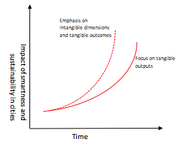
How might we create cities that are not only smart, but wise?

We asked out panel: Smart cities are coming. It is important that they be as much about nature, health, and well-being as traffic flows, crime detection, and evermore efficient provision of utilities. How will this be done?

Helga Fassbinder

about the writer
Helga Fassbinder

Helga Fassbinder is an urban planner, political scientist, writer, professor emeritus of the University of Technology Eindhoven, The Netherlands, and University of Technology Hamburg, Germany. She lives in Amsterdam and Vienna. Fifteen years ago, she developed the concept of 'Biotope City - the City as Nature', and started the Foundation Biotope City, which is exploring new urban aesthetics and ethics. The Foundation has produced the BIOTOPE CITY JOURNAL since 2006. Meanwhile the first 'Biotope City' is being built in Vienna. www.biotope-city.net

Helga Fassbinder

To read this post in German see here.

A needed smart city filter: Do smart city measures contribute to a more socially fair good life, without externalising associated costs, spatially and socially?

Smart city as a social-ecological challenge

The term “smart city” is used by actors of the cities—political decision-makers, planners, administrations, companies, housing associations, etc.—in the mood for very different programs and objectives. One gets the impression that “smart” is a label which is often used only to “sell” any upcoming investment/measure, as it calls up the image of technological innovation and progress even if, in reality, the technological innovation is only marginal or its effects are questionable.

First of all, it’s about giving the concept of the smart city a definition.

We may agree that we live in times of global ecological crises, going further: in times of socio-ecological crises. By this I mean that we live in times of a multi-faceted crisis, which in many countries cause or at least intensify a social crisis by reaching or even exceeding the limits of ecological resilience. Thus, one can speak of a global social-ecological crisis. Migration flows and wars give expression to this.

That means as a consequence: if the renewal and transformation of our cities into smart cities is to have a forward-looking positive impact, then they must contribute to solving or at least mitigating these multiple socio-ecological crises rather than to exacerbate global negative ecological and social effects.

To further clarify the definition of “smart city” let’s add the following attributes: sustainable, resource efficient, ecological, nature friendly, and socially acceptable.
But what do these attributes imply in the concrete? This raises the question: How far are we going with sustainability and resource-saving, etc.?

I propose to add, as a sort of “filter” for “smart city” measures in the above sense, by asking the following questions:

  • Do these measures contribute to a more socially fair good life, without externalising associated costs, spatially and socially?
  • Are the smart city measures contributing to a global social-ecological transformation?

Our current Western-style life is largely based on the spatial and social externalisation of the costs of its production: costs of production in so-called low-wage countries, exploitation of natural resources in such countries, export of our waste to such countries etc. This means that our good life is based on the misery of humans and the extermination of nature (mineral resources, biodiversity, water, nature’s ability to regenerate in general, etc.) in these countries.

For this fact the German political scientists Ulrich Brand and Markus Wissen have coined the term “imperial mood of living”. A few months ago, they published a book on this subject, subtitled “The Exploitation of Man and Nature in Global Capitalism” (1) The publication has received great attention and recognition and has come on the bestseller list of the magazine “Der Spiegel”.

This great response is pleasing because it shows that many people are aware that their lifestyle is leading to overexploitation of nature and people in a global dimension. Reflecting this, they may also be aware that this “imperial mood of living” in the long run will destroy the very basis of their own well-being: it accelerates climate change worldwide, it is destroying the basis of life of more and more people in these countries and depletes natural resources (e.g., rare earths) at a speed that makes their replacement by technological innovations very questionable.

What does that mean for the concept of the smart city? What does that mean for us, who are involved as experts in the planning and implementation of so-called “smart” measures?

First of all, any measure planned under the “smart city” label should be reviewed not only for its impact on climate and nature at the regional and national level, but it should also be checked as rigorously as possible with regard to the possible global externalisation of effects and costs.

Just a few examples:
This criteria brings into question many small measures currently being touted as “smart”. For instance when small human activities, easily carried out by hand, (e.g., to switch on a light) are unnecessarily are replaced by electronic triggers, and thus now require the consumption of, among other things, rare earths.

Even the conversion of individual vehicles to electric cars, a change now propagated in many countries, and touted as sustainable, comes into question. The decision to convert to electric cars results not only the premature replacement of fossil fuel-powered cars (and thus a destruction of value), justified with gains in energy efficiency and reduced carbon emissions, but it also neglects to account for the resource consumption and carbon emissions made by the production of these new electric cars. It also does not take into account the consumption of raw materials for electric batteries, materials which perhaps do not even exist in sufficient quantities for the scale needed. What is the balance sheet?

In addition, the switch to electric vehicles also requires a new, large-scale infrastructure of charging stations, also associated with an increased consumption of resources, and rare earths.

I do not argue against electric cars in general. But for improving the flow of individual traffic, the more sustainable alternative, instead of subsidising each new electric car, is certainly to give priority to the development of the public transport network, and, for urban traffic and transport, to promote and support the use of human-powered forms of transport, such as bicycles, with safe bicycle lanes and safe parking.

On the opposite side, there are other “smart” measures which certainly do not or hardly have any negative externalised effects. This includes, for example, the comprehensive greening of buildings, urban farming, and urban gardening. These measures contribute to the strengthening of native biodiversity, they reduce summer temperatures, delay the outflow of water during prolonged heavy rain, and can support small-scale corporate structures in gardening and agriculture, with no or minimal externalisation of effects and costs.

Conclusion:
The critical review of any as “smart” planned measure concerning their global spatial and social impacts, could lead, in the end, to a checklist of the social and ecological gains and deficits of “smart measures”. Such a checklist could help planners, critical public, and decision-makers to decide whether or not to carry out what one has in mind and, with regard to minimizing the effects of externalisation of costs, could help us look for better or best alternatives.

Such a checklist would contribute to an efficient social-ecological transformation that could modify and reduce the “imperial mood of life” by transforming our cities.

Notes:
Brand, Ulrich/Wissen, Markus (2017): The Imperial Mode of Living. In: Spash, Clive (ed.): Routledge Handbook of Ecological Economics: Nature and Society. London: Routledge, 152-161.

Brand, Ulrich/Wissen, Markus (2017): Social-Ecological Transformation. In: Noel Castree, Michael Goodchild, Weidong Liu, Audrey Kobayashi, Richard Marston, Douglas Richardson

Görg, Christoph/Brand, Ulrich (lead authors)/Haberl, Helmut/Hummel, Diana/Jahn, Thomas/Liehr, Stefan (2017): Challenges for Social-Ecological Transformations: Contributions from Social and Political Ecology. In: Sustainability 9(7), 1045; doi:10.3390/su9071045

SMART CITY ALS SOZIAL-ÖKONOMISCHE HERAUSFORDERUNG

Die Bezeichnung ‘smart city’ wird von den Akteuren der Städte – politischen Entscheidungsträgern, Verwaltung, Unternehmen, Wohnungsbaugesellschaften e.a. – für höchst unterschiedliche Programme und Zielsetzungen gebraucht. Man gewinnt den Eindruck, dass es sich um ein Label handelt, mit dem vielfach lediglich jeweils anstehende Investitionen/Massnahmen ‘verkauft’ werden sollen, da es das Bild der technologischen Neuerung auch dann aufruft, wenn die technologische Neuerung nur marginal oder selbst in ihren Effekten fragwürdig ist.

Es geht also erst einmal darum, dem Begriff der smart city eine Definition zu geben.

Wir sind uns vielleicht darüber einig, dass wir in Zeiten globaler ökologischer Krisen leben, noch weiter gehend: in Zeiten sozial-ökologischer Krisen. Damit ist gemeint, wir leben in Zeiten einer multiblen Krise, die durch das Erreichen der Grenzen der ökologischen Belastbarkeit in vielen Ländern eine soziale Krise hervorruft oder zumindest verstärkt. Somit kann man von einer globalen sozial-ökologischen Krise sprechen. Migrationgsströme und Kriege geben davon Ausdruck.

Wenn also der Umbau und die Erneuerung unserer Städte zu ‘smart cities’ einen in die Zukunft weisenden positiven Sinn haben soll, dann müssten sie beitragen zur Lösung oder zumindest zur Milderung dieser vielfältigen sozial-ökologischen Krisen, anstatt sie in ihren globalen Effekten noch weiter zu verschärfen.

Fügen wir also zur näheren Bestimmung der Definition von ‘smart city’ die folgenden Attribute hinzu: nachhaltig, ressourcenschonend, ökologisch, Natur schonend, sozial verträglich. Aber was implizieren diese Attribute dann im Konkreten? Hier erhebt sich die Frage: Wie weit geht die Reichweite von ‘nachhaltig’, ressourcenschonend etc. ?

Ich schlage vor, gewissermassen als eine Art von ‘Filter’ für ‘smart-city’-Massnahmen im obigen Sinne die folgende Frage hinzuzufügen:
Tragen diese Massnahmen bei zu einem sozial gerechteren guten Leben, ohne damit verbundene Kosten räumlich und sozial zu externalisieren?

Tragen die Massnahmen bei zu einer globalen sozial-ökologischen Transformation?

Unser heutiges, von westlichen Standards geprägtes Leben ist in hohem Masse basiert auf der räumlichen und sozialen Externalisierung von Kosten seiner Herstellung: Kosten der Produktion in sog. Billiglohn-Ländern, Ausbeutung der natürlichen Ressourcen in solchen Ländern, Export unserer Abfälle in solche Länder. Das heisst: unser gutes Leben ist auf dem Elend von Menschen und der Vernichtung von Natur (Bodenschätze, Biodiversität, Regenerationsfähigkeit der Natur) in diesen Ländern begründet.

Die deutschen Ökonomen Ulrich Brand und Markus Wissen haben dafür den Begriff der ‘imperialen Lebensweise’ geprägt. Sie haben vor einigen Monaten ein Buch zu diesem Thema publiziert, das den Untertitel trägt ‘Zur Ausbeutung von Mensch und Natur im globalen Kapitalismus’. Die Publikation hat grosse Aufmerksamkeit und Anerkennung gefunden und ist auf die Bestseller-Liste des Magazins ‘der SPIEGEL’ gekommen.
Diese grosse Resonanz ist erfreulich, denn sie zeigt, dass doch vielen Menschen bewusst ist, dass mit ihrer Lebensweise Raubbau getrieben wird an Natur und Menschen in einer globalen Dimension. Es wird ihnen in der Reflexion dessen vielleicht auch bewusst, dass diese ihre ‘imperiale Lebensweise’ à la longue auch die Basis ihres eigenen Wohllebens zerstören wird: Sie beschleunigt den Klimawandel weltweit, sie entreisst immer mehr Menschen in diesem Ländern ihre Existenzgrundlage und erschöpft natürliche Ressourcen (zB seltene Erden) in einem Tempo, dass deren Ersatz durch technologische Neuerungen sehr fraglich ist.

Was heisst das nun für das Konzept der ‘Smart City’? Was heisst das für uns, die wir als Fachleute eingebunden sind in Planung und Durchführung von sog. ‘smarten’ Massnahmen?

Als erstes: Jede Massnahme, die unter dem Label ‘smart city’ geplant wird, sollte nicht nur unter der Frage ihrer Auswirkung auf das Klima und den regionalen und nationalen Naturhaushalt überprüft werden, sondern ebenso streng im Hinblick auf mögliche globale Externalisierung von Effekten und Kosten überprüft werden.

Nur einige Beispiele:
Damit werden bereits viele kleine Massnahmen fragwürdig, die als ‘smart’ angepriesen werden, z.B. überall dort, wo unnötigerweise kleine menschliche Handgriffe durch elektronische Steuerung (und damit dem Verbrauch von u.a. seltenen Erden) ersetzt werden. Auch der nun in vielen Ländern propagierte Umstieg des Individual-Verkehrs auf Elektroautos, der als nachhaltig angepriesen wird, wäre noch zu hinterfragen: Er zieht nicht nur den vorzeitigen Ersatz von fossil angetriebenen Autos (und damit eine Wertezerstörung nach sich), wobei dem energetischen und CO2-Gewinn der Ressourcenverbrauch und CO2-Ausstoss bei der Produktion der neuen Elektroautos gegenüber steht, ganz abgesehen von den für Elektrobatterien notwendigen Rohstoffen, die es in diesem Ausmass wohl garnicht in ausreichend gibt. Was ist die Bilanz? Zudem: Es bedarf auch einer grossflächigen neuen Infrastruktur mit Ladestellen, auch dieses ist mit einem gesteigerten Verbrauch von Ressourcen, u.a. den seltenen Erden, verbunden.

Die nachhaltigere Alternative, um den Verkehrsflow zu verbessern, ist wohl, dem Ausbau des Netzes von öffentlichem Verkehr Vorrang zu geben, und für den Nahverkehr den Gebrauch von Verkehrsmitteln mit ‘Menschenantrieb’, sprich Fahrrädern, mit sicheren Fahrradwegen und Unterstellplätzen zu unterstützen.

Andere ‘smarte’ Massnahmen hingegen haben deutlich keine oder kaum negative externalisierte Effekte. Dazu gehört die umfassende Begrünung von Gebäuden und Urban Farming. Sie tragen zur Stärkung der einheimischen Biodiversität bei, senken sommerliche Temperaturen, verzögern den Abfluss von Wasser bei langdauernden Starkregen und können kleinteilige Unternehmensstrukturen in Gärtnerei und Landwirtschaft unterstützen, mit keiner oder nur minimaler Externalisierung von Effekten und Kosten.

Fazit:
Die kritische Prüfung jeder als ‘smart’ geplanten Massnahme hinsichtlich ihrer globalen räumlichen und sozialen Effekte könnte zu einer Liste führen, anhand der PlanerInnen, eine kritische Öffentlichkeit und EntscheidungsträgerInnen entscheiden können, ob diese Massnahme zu verantworten ist.

Eine solche Liste wäre ein Beitrag zu einer effizienten sozial-ökologischen Transformation, die im Umbau unserer Städte den imperialen Charakter unserer Lebensweise modifizieren und verringern könnte.

Fussnoten:
Brand, Ulrich/Wissen, Markus (2017): The Imperial Mode of Living. In: Spash, Clive (ed.): Routledge Handbook of Ecological Economics: Nature and Society. London: Routledge, 152-161.

Brand, Ulrich/Wissen, Markus (2017): Social-Ecological Transformation. In: Noel Castree, Michael Goodchild, Weidong Liu, Audrey Kobayashi, Richard Marston, Douglas Richardson

Görg, Christoph/Brand, Ulrich (lead authors)/Haberl, Helmut/Hummel, Diana/Jahn, Thomas/Liehr, Stefan (2017): Challenges for Social-Ecological Transformations: Contributions from Social and Political Ecology. In: Sustainability 9(7), 1045; doi:10.3390/su9071045

Gary Grant

about the writer
Gary Grant

Gary Grant is a Chartered Environmentalist, Fellow of the Institute of Ecology and Environmental Management, Fellow of the Leeds Sustainability Institute, and Thesis Supervisor at the Bartlett Faculty of the Built Environment, University College London. He is Director of the Green Infrastructure Consultancy (http://greeninfrastructureconsultancy.com/).

Gary Grant

An adequate tranche of smart city investment should be spent on monitoring the environment, so that designers, planners, and managers can invest money to save money, restore nature, and make our cities more resilient to climate change.

Our knowledge of cities is limited. Millions of us take in the sights, but we don’t necessarily understand what we see and how it works. We take the built environment for granted and rarely take the time to analyse it or make plans to improve it. Help is needed from all-seeing and quick-thinking sensors and computer networks. We don’t have a full picture of the biodiversity that occurs in cities. There are maps which show the location and extent of habitats and various green spaces. Trees, especially street trees, are usually catalogued (take for example Singapore’s heritage trees). Knowledge of wild vegetation in cities is incomplete. Urban naturalists record birds in most cities, with specialists looking at particular species, like the swift for example, but investigations of invertebrates are uncommon. The first task for the smart city is to use cameras and sensors, working with artificial intelligence, to complete the mapping and cataloguing of natural features within our cities. This will include soils, watercourses and waterbodies, habitats (both on the ground and on buildings), as well as species. Sound, for example, is being used to identify and map wildlife. An interesting example of this is the monitoring of bat activity in real time in London’s Olympic Park. The description and cataloguing of urban nature need to be completed, so that we can see where it is missing, where it can be enhanced, and where management should be focussed, to restore nature for its own sake and for the well-being of citizens. Smart city technology can be harnessed for this purpose. It will make monitoring more affordable and more effective.

Nature affects and is affected by its physical setting. Surprisingly little is known about the various and changing microclimates in our cities. The phenomenon now known as the Urban Heat Island Effect (UHIE) was first described more than 200 years ago, however, ask city planners about how much of a problem the UHIE is in a particular precinct, chances are they will not know. The permeability of surface cover, evapotranspiration rates, and surface temperatures are inter-related, and these parameters can be measured using infra-red photography. An excess of sealed surfaces can lead to problems with surface water flooding and combined sewer overflows which pollute watercourses. Cameras and digital thermal sensors can be networked in order to monitor the whole city, looking for hot spots, where green infrastructure can be created to fix these problems.

Air quality and water quality are monitored, usually to the minimum standard required by legislation in any jurisdiction. New York City, for example, monitors air quality at 150 stations. Water quality tends to be measured in selected watercourses at particular times in the year or in response to incidents. It is well established that vegetation intercepts and absorbs air pollution, and that soil cleans water, however little is known about how particular combinations of soil and vegetation in urban settings provide these ecosystem services. As the costs of sensors that measure pollutants fall, it should be possible to monitor entire urban areas, to understand where the most serious problems are occurring and how natural features are affected and are reducing the impacts of pollution on citizens. More detailed and wider scale monitoring will reveal more about how polluted cities are but will also help city planners to prioritise expenditure and target interventions and continuing management.

We are told that there will be significant investments in smart city initiatives. 1.2 trillion dollars by 2022 according to one estimate. Without a concerted effort from those of us interested in nature, it is possible that almost all of this investment will be centred on measuring the flows of energy within wires and water within pipes, on smoothing traffic flows, detecting crime, and servicing businesses and government. This is all well and good for the most part. However, an adequate tranche of that investment should be spent on monitoring the environment, so that designers, planners, and managers can invest money to save money, restore nature and make our cities more resilient to climate change. We need to be shielded by more water, soil, and vegetation and this must be added in a smart way, which will require smart city techniques and technologies.

Pratik Mishra

about the writer
Pratik Mishra

Pratik Mishra is a PhD Student in Human Geography. His work pursues the urban’s ecological hinterland to find more than just the sheer quantity of resources or waste that the urban expends in its metabolism, and rather the villages and the lives that get entangled in these resource flows. He hopes that these stories will help us understand better the relations between the core and periphery of Indian cities.

Pratik Mishra

The dangers of anti-poor smartness in Indian cities

Smart city policies in India could have much value, but are also very much part of India’s post-developmental neoliberal turn in politics that portends either indifference or active harm for the urban poor.

To be honest, I was disappointed when I found out that “smart cities” existed already as a buzzword in urban governance outside of India. When our Prime Minister Narendra Modi in 2015 announced the Smart Cities programme to develop 100 cities in India through better core infrastructures, more information technology solutions in governance, and cleaner, greener surroundings, I beleived he would be the one to bring this term into vogue and give it shape. He is known for inventing new terms and conflating one thing to another (This is not a criticism). Recently in celebrating the progress in Ease of Doing Business rankings, he stated that this jump in ranking also represented a growth in “ease of living” for citizens. Why wouldn’t he just use the existing Human Development Index which ranks India 131 out of 188 countries and target attention at improving there? (This is a criticism).

The Smart City programme in India is one-of-its-kind in terms of not laying down standards for “smartness” a priori. The idea was to look at the projects and ideas urban bodies would propose in their bids and then create standards tailor-made for those projects. Even that ambition was set aside as the Ministry set aside benchmark standards instead relying on a fuzzier liveability index to just rank smart cities that were already smart. To me, this attitude of fuzziness is welcome.

It’s very clear that the smart cities, which are designed as retrofitted, renewed, or greenfield satellites to existing cities, are there to attract investments. Traffic flows, crime detection and efficient utilities are the means to this, objectives biased towards certain classes of citizens. In talking about nature, health and well-being, my argument is on how smart cities could be more pro-poor without suggesting the policy be any more welfarist (in the redistributive sense, as I only wish it would be). Such policies are not new in India; very much part of its post-developmental neoliberal turn in politics portends either indifference or active harm for the urban poor. David Harvey speaks of the “spatial fix” where socio-spatial arrangements like infrastructures are reconfigured in limited geographies to reflect the imperatives of capital. Capital perpetually seeks spatial fixes that would address its crises and contradictions through geographic expansion and commodification of hitherto underdeveloped resources. Using Harvey’s analogy, smart cities provide yet another syringe for capital’s addiction to expanding its frontier across space. Niall Brenner’s writing on the rescaling of state space allows us to articulate how smart cities represent uneven legal regimes and infrastructures typical of an entrepreneurial approach to urban governance rather than a welfarist-one.

These discourses obviously deal a bad hand to the urban poor. However, within these neoliberally-oriented regimes, the academic wisdom that urban researchers repeatedly stumble upon is that the policy and practice most meaningful to the poor is often located in the interstitial and residual spaces of policy. This insight is the veritable mother lode that keeps producing high-quality academic research bringing out different versions of the poor’s complex and entangled negotiations with the state. Political society (Chatterjee), insurgent citizenship (Holston), quiet encroachment of the ordinary (Bayat), occupancy urbanism (Benjamin), etc. all state that the poor, so often unfairly finding themselves on the wrong side of legality, find flexible arrangements, negotiations with street bureaucrats and political patronage relations useful. Subverting policy serves a greater good. Obviously, the rich exploit fuzziness and commit illegalities even more ruthlessly but that is not something to get into now.

Finally, just from my fieldwork which looks at drinking and wastewater canals that service the metabolism of Gurugram city, I present a sort-of-related example. The canals chart their way across many villages as they bring water to the city or take sewage away. They are assumed to be largely inert flows with transmission loss only on account of evaporation for drinking canals, and irrigation is allowed for wastewater canals though not regulated. These flows are anything but inert though, as through seepage, irrigation and theft, they radically impact the lives and livelihoods of farmers and residents in peri-urban villages. In the absence of any laid down rules or water user associations, farmers utilize wastewater from the sewage canals drawing on local historical norms of cooperation to regulate sharing and minimize conflicts. Seepage from the drinking water canals alters the groundwater table in nearby fields, reducing productivity on low-lying adjacent lands but also creating opportunity structures for farmers farther away who benefit from the groundwater. Interestingly, farmers pumping out water helps the canal structure as it reduces pressure from the high water table. A lot of unregulated activity takes place in the backwaters of policy which is simultaneously often arbitrary and unjust but also regulative and beneficial. The smart city approach of strongly attacking transmission losses, surveying water use and imposing top-down regulations, entrusting unaccountable parastatal institutions instead of local government with responsibility is just the prescription for doing more harm than good here.

A Smart Cities Readiness Guide produced by an industry body describes a smart city as “one that knows about itself and makes itself more known to its populace”. I don’t think smart cities would necessarily produce the right kinds of knowledge in their statistics. If the harder institutional, democratic changes won’t be invested in, I hope spatial fixes like smart cities partially fail so it may allow constituency-level negotiations, flexible arrangements and limited surveillance, all of which have enabled the urban poor to exercise their democratic agency. A technocratic operationalization of smart city principles devoid of adequate human interfaces and contextual decision-making (even if such practices often appear to be corrupt) would only further limit the spaces of economic and cultural operation for those already immiserated by urban life.

Vishal Narain

about the writer
Vishal Narain

Vishal Narain is Professor, Public Policy and Governance, at the Management Development Institute Gurugram, India. His academic interests are in the inter-disciplinary analyses of public policy processes and institutions, water governance, peri-urban issues and vulnerability and adaptation to environmental change.

Vishal Narain

When we talk of a smart city, what (and whom) do we exclude and include, on what basis, and for which benefits?

Smart cities are coming indeed, but how can they be wise and sustainable? I think this requires challenging some of our commonly held views and notions. First, I find it disorienting that in this age and time, we still talk of a “city”, as if it is some well-defined entity, marked out in space and time. Implicitly, the definition of a city assumes some spatial or administrative unit marked out or posited against a boundary. Typically, we think of a city as the opposite of what is not a city; for instance, and typically of what is “rural”. In the emerging context of the Global South, the urban-rural dichotomy is fast disappearing. We need to reimagine what a city is. Focusing on the city narrowly may mean compromising the integrity of ecosystems that support it, or from which the city draws its resources.

So, when we talk of a smart city, what (and whom) do we exclude and include, and on what basis? Is this the city core, the jurisdiction boundary, or also the peripheries whose resources are guzzled by the growing city? I live in Gurugram, and my residential gated colony is right next to a village settlement area, on whose (former) agricultural land my house is built. Is that village also “city”? The institute where I work, Management Development Institute, shares a boundary wall with a village called Sukhrali, which is now under the Municipal Corporation of Gurgaon. Just as I leave the main gate of the institute, I see rural folk sitting on cots and playing cards while smoking the hookah. (Hookah is a communal pipe. Village folk collectively smoke tobacco, taking turns.) Among them are former farmers, real estate agents, potters, craftsmen, and transport operators. Is my institute located in a city or a village?

In this age and time, when rural-urban boundaries are blurring in the Global South, programmes targeting “rural” or “urban” areas mean little. I would go for “smart watersheds”, or “smart urban agglomerates”, or “smart aquifers”. We need planning entities and approaches that recognize rural-urban relationships, flows of goods and services between rural and urban areas, dynamic and ever-evolving, or the relationships between social and ecological systems.

Having said that, if smart cities are conceptualized the way that they are right now, how can they be safe and sustainable? Where is the role for technology and infrastructure?

Urban farming is a new trend catching on in modern cities. Using the biodegradable wastes of our homes to grow our own vegetables is catching on. This helps in many ways; the domestic kitchen waste is used, it helps us move towards a circular economy. We consume vegetables whose source we know, and we recognize that they are not contaminated by chemical fertilizers and pesticides. There is a great potential for technology (e.g., through Facebook) to connect people who do this, popularize kitchen gardens and inspire those who would want to be inspired. Technology can help us reduce our ecological footprint and move towards a circular economy.

If we widen the notion of the city to include the surrounds and peripheries that feed it, it may make us see the smart city in a new light. This will then translate into improving rural internet connectivity and strengthening initiatives that foster the use of technologies in rural areas to improve access to information and lower transaction costs; for instance, in the Indian context, such initiatives as e-choupals (which uses information technology to provide information to farmers about market prices). It may mean improving rural-urban connectivity (and not just widening highways and building new expressways). This will improve rural communities’ access to modern health care and education and enable better marketing of perishable produce. It will ensure the safety of rural women and widen their access to urban markets.

We should also use modern technology to generate knowledge on and create greater awareness of the extent and impact of the degradation of natural resources like water bodies that smart cities consume, the loss of forest cover, the increase in built-up area and reduction of groundwater recharge. Expanding infrastructure means creating “more of” something. More for some people usually means less for others; violating the norms of intra-generational equity.

Eric Sanderson

about the writer
Eric Sanderson

Eric Sanderson is a Senior Conservation Ecologist at the Wildlife Conservation Society, and the author of Mannahatta: A Natural History of New York City.

Eric Sanderson

What we truly need to improve the nature of cities are smart and wise people and institutions, who consciously and deliberately use data and information to create natural cities.

Like many Americans of a certain generation, I spent a portion of my misspent youth hunched around a table playing Dungeons & Dragons. One of the things I liked best about D&D is that at the beginning of each game, we would roll three dice to give our characters a set of defining attributes: strength, intelligence, wisdom, constitution, dexterity, and charisma. I thought it was brilliant that the designers of the game recognized the difference between intelligence and wisdom, which is sorely lacking in most of the 21st century world, and in particular, in the discussions around smart cities. Intelligence, smartness, information is the capacity to know facts about our cities. Wisdom, motivation, justness, is the capacity to act positively and bravely on that information to make the city better. We have many examples of intelligent people who do unwise things; we may know some of those rare people who are wise without being unusually intelligent, but what we truly need to improve the nature of cities are smart and wise people and institutions, who consciously and deliberately use data and information to create natural cities.

A natural city by definition fits seamlessly into its environment, much as forests, grasslands, and waters do; it gives as much as it takes; and it lasts for a long time.

In New York City, my colleagues and I have been trying to generate the smart, wise, natural city that we believe is essential to the future. One part of that is having a shared set of goals for the nature of the city, as Bram Gunther and I wrote about previously here. Nature in our view (and the view of over 40 other institutions) should be seen as fundamental to the functioning of the city as public safety, or education, or health. In New York we have police and fire departments to keep us safe, and departments of education and health to help us be smart and healthy, but the management of nature is scattered across agencies (NYC Parks Department, NYC Department of Environmental Protection, New York State Department of Environmental Conservation, National Park Service, the U.S. Environmental Protection Agency, etc.), with no clear lines of responsibility that link back to a shared set of goals for the city as an integral and wise whole.

We have also been working hard to give New Yorkers tools to generate and share ideas about the city of the future. As I wrote about here, Visionmaker.nyc is a free online tool for ecological democracy. Anyone with an internet connection can zoom to a neighborhood of interest, see the ecosystems of that part of the city now as well as the historical, pre-development landscape, then reimagine the neighborhood they would like to see in the future. Those scenarios of a future can take into account climate change and/or play around with lifestyles through integrated toolsets. Each change generates a call to a set of models that give comparative and quantitative metrics about the water cycle, carbon flows, biodiversity patterns, and population density, where the user’s vision is evaluated next to that present-day neighborhood and the area as a natural landscape.

Finally, as this brief gloss on Visionmaker suggests, we have found it incredibly useful to contrast New York today with its pre-development, “wild” state, via the Mannahatta and Welikia Projects. Historical ecology provides unique perspectives that speak to wisdom even more than intelligence. Urban historical ecology reminds us that our cities have not always had their current form, despite their monumentality. The past gives us insights into the way nature shapes the land and waters where our cities are built. If the sea level rose 120 meters, as it has in New York City over the last 20,000 years, should we be shocked that it may rise another meter over the next century? Most importantly though, historical ecology inspires. Nature is beautiful and fascinating and robust in ways that speak volumes to our overcrowded and over-busy time. Sometimes one can glimpse that beauty today, in the rustle of leaves in a city park or in the motion of salt marsh grasses as the tides come in, but to realize the former vastness of this landscape and the productivity of its indigenous ecosystems is to open our hearts to the potential of the future and sting us with visions of what has been lost.

Bernhard Scharf

about the writer
Bernhard Scharf

Born in Salzburg, I found my way to the University of Natural Resources & Life Sciences Vienna to study landscape planning and architecture. My master thesis already dealt with ecological and economical solutions for turf areas, so called flowering turf. 2006 I started my scientific work at the Institute of Soil Bioengineering and Landscape Construction. The focus from then on was the development of technical solutions to allow the broad application of green infrastructure in the context of urban challenges. In 2014 I co-founded the Green4cities company to close the gap between research and planning praxis. Today I am senior scientist at BOKU and CTO of the G4C company. More details here.

Bernhard Scharf

The smart city community needs intensive exchange and mutual learning to find the best solutions to integrate human needs in urban planning, comprehensively and efficiently.

What is a smart city? Is it a buzzword? Sometimes this impression is created, especially when you look at various real estate projects that are advertised as “smart” because of an info screen at the entrance hall, etc. while being absolutely conventional otherwise.

Is there a clear definition what a smart city is? In the field of research “smart cities” are understood as highly diverse. Most smart city research projects focus on a set of topics relevant to the scientists involved, such as the internet of things, social sciences or new mobility concepts, green infrastructure, etc. Apart from the thematic diversity, there is a common interface to all projects: they address the needs of people today and in the future. What we can observe is a significant change of perspective in how we plan and develop our cities: a human-centered planning approach going beyond the scope of traditional planning. No longer do people have to adapt to the city. It’s the other way around. The city has to deliver what people need.

That means that urban planning and design changes dramatically. Many people, especially investors but also experts, are afraid of the change towards smart cities. They try to keep their routine and patterns. While change is perhaps the only constant there is.

So how can we proceed on this path and create smart cities? I think we have to change attitudes, traditions, patterns, and routines. But most of all the following two aspects:

More resources and time for planning processes

The planning of new urban districts or retrofitting built city areas is highly complex. Thanks to modern technologies such as building information modeling (BIM), etc. the planning is extremely efficient and allows planners to address many aspects in a short time; and almost the same time (and money) for planning as many decades ago, when things were not as complex. Developers and municipalities expect that the planning experts comply with the given time frame and regulatory framework. As a result, we see planning experts struggle to balance the scope of services, time and money, trying to achieve the best results with the available resources.

The role of planning processes, especially concerning smart cities, needs to be much more appreciated. We need to be aware of the fact, that the cities we build today will remain—thanks to high European technical standards—for many, many decades, very likely until 2100 or beyond. At that time different climatic framework conditions, urban density and age-composition of the society will be a given. A smart city needs to account for all of these changes, today. Therefore, the planning process needs to be interdisciplinary including civic participation, allowing for work on interfaces and synergies with fewer budget and time restraints. Planners have to point out their importance in such complex planning processes to define the quality of projects and security of the investment for a very long time. Researchers estimate that, regarding an average planning project, the planners budget accounts for only 3 percent of the total lifetime cost of buildings, while defining the 97 percent of lifetime cost significantly!

Understanding the city as nature

More than 70 percent of Europeans live in a city today. Every weekend people tend to “visit” a piece of nature, a park, a forest, a mountain. Why? There is no regulation or obligation to do so. As proven in many health studies nature experience helps to recreate and relax, improving health, concentration and so forth. Obviously, citizens’ lack of nature experience in their direct vicinities, the urban fabric, leaves them with great desire and demand for nature.

In the history of city development nature has been perceived as a source of danger, out of control and order. As a consequence, cities somehow banned nature or kept it “clean” and under control in pots or parks. “We need to stop war against nature”, claimed Gary Grant at the European Union Green Infrastructure Conference 2017 in Budapest. Ecosystem services reduce urban heat island effects, flash flooding, air pollutants, noise, and increase the attractiveness of the urban fabric, creating healthy and appropriate habitat conditions for people. Nature has to be understood as an essential part of forward-looking and smart cities, as partner and ally to overcome many aspects of urban deficiencies.

Smart cities are coming. There is no doubt about that. There are some remarkable projects realized in Europe, but the process is ongoing and still experimental in a way. The smart city community needs intensive exchange and mutual learning to find the best solutions to integrate human needs in urban planning comprehensively and efficiently.

Huda Shaka

about the writer
Huda Shaka

Huda's experience and training combine urban planning, sustainable development and public health. She is a chartered town planner (MRTPI) and a chartered environmentalist (CEnv) with over 15 years' experience focused on visionary master plans and city plans across the Arabian Gulf. She is passionate about influencing Arab cities towards sustainable development.

Huda Shaka

The first step in creating a smart city is to set holistic, measurable objectives that address the needs and aspirations of its residents.

While smart cities may be coming, many of the concepts, technologies, and partnerships that will make them happen are already here today. Some see commercial and property development opportunities in this new world, others see data and privacy risks. A third group is emerging who are advocating for utilizing smart technology to offer entire communities (not just paying clients) healthier, better-connected environments and wider economic opportunities. Ultimately, smart cities focused on nature, health and well-being will also need traffic flow, crime, and utilities data. The difference lies in the ownership, access to, and usage of the data to serve a higher purpose.

As an example, traffic flow data can be used to achieve both smoother vehicular traffic and safer planned pedestrian crossing conditions (location and signal timing) for improved health. As long as the wider community does not have access to this data or an understanding of how it is used, there is a risk that it will be used to maximize benefit for private interests.

To address this issue, a number of factors must be considered. The first step is to set holistic, measurable objectives for a city which address the needs and aspirations of its residents. Next is determining the type of data needed to manage and assess a city’s performance against the objectives. It is often at this step that government departments and officials stumble, as they focus on measuring and reporting what is easily measurable as opposed to what is important to be measured. For example, a public transport department may measure the total distance covered by bus trips, as opposed to the percentage of residents served by buses or the number of car trips avoided. Clearly the latter two indicators are more complex; however, they provide a much better basis for decision making as they link more directly to quality of life from a social and environmental perspective. It is likely that complex indicators may require more creative ways of measurement, including qualitative user satisfaction surveys, cooperation across government entities, participation by the private sector, and engagement with the community. This is all achievable in our age of smart cities.

Finally, there is the process of sharing this information and analysis with all city residents and users, in an accessible way—both from a technology and language perspective, amongst other factors. This a good test of the type of data being collected. Are the data telling community members what they want to know about their built and natural environment? Does it empowering them to make more informed decisions? Or are the data mostly being used to demonstrate that a government is “smart” or that a particular technology is a good investment?

The digital justice principles (access, participation, common ownership, healthy communities) provide insights into what a world of people and nature focused smart cities could look like. It is a city where data are collected and shared for the benefit of all. This is partly about what data are collected but mostly about who has access to the data and technology, and what benefit they bring to communities.

Shaleen Singhal

about the writer
Shaleen Singhal

Dr. Shaleen Singhal is a Professor at TERI School of Advanced Studies with 21 years of research and academic experience working on sustainable urban development issues in India and UK. He is a Fellow of the Higher Education Academy, UK and a Visiting Fulbright Fellow for Yale University, US.

Shaleen Singhal

Intangibles for tangible outcomes

Smart city efforts will be futile if the current challenges of inequality, poverty, and unsustainable consumption are not addressed.

A new and enhanced comprehension of smart cities is elemental particularly in the context of cities in emerging economies that display a greater degree of complexities and barriers. Effectiveness needs to take over efficiency! Traditional indicators on outputs relating to investment and infrastructure creation require a shift towards outcomes relating to the quality of life of the city’s inhabitants including the vulnerable population of urban poor. While smartness may ascertain a city’s capacity to mobilize advance technologies including information and communication technology (ICT) in establishing sentient cities with futuristic infrastructure, it should also influence change in a city’s reach and delivery of quality services. To benefit current and future billions that are and will be living in emergent cities, leapfrogging and breakthrough in thinking, strategy, action, and evaluation are needed that must go beyond change as usual. An effective way to realise this is by engaging with young minds and to create a new cadre of professionals with systemic thinking and with an appreciation of the sustainability dimension of urban development. Institutions with a conventional outlook have demonstrated a limited capacity to adapt towards the need for upfront integration of sustainability into all tracks of city development. Globally, this is an apt time for such integration particularly by resurgent cities that are in the process of redevelopment. It is critical for cities to create synergies among smart city strategies, redevelopment strategies, and strategies for resilience to comprehensively enhance competitiveness with enduring sustainability.

For cities in emerging economies such as Brazil, Russia, India, China, South Africa (BRICS), and others, smart city led technological advancements need to fortify redevelopment strategies such as retrofitting of ageing building stock and upgradation of infrastructure for resource efficiency and low carbon development. Such advancements shall also promote a shift from greenfield to brownfield investments while dealing with inherent socioeconomic and environmental challenges of inner cities. Any smart city aligned progressions can be truly effective if they also augment a city’s resilience with the ability to absorb, recover and prepare for future economic, environmental and physical, social and institutional shocks.

It is evident that agile cities such as from the BRICS region are growing in terms of population and gross domestic product (GDP), emerging as important destinations for investments, adopting innovations relating to technology, research and development, and becoming economically competitive. However, these cities also witness numerous challenges such as rising income inequality, growing slum populations, unsustainable consumption patterns, increasing pollution levels, and resource scarcity. Any changes towards being a smart city will be futile without measurable contributions in addressing such challenges and positively influencing the human development index (HDI) alongside economic competitiveness. Real opportunity should not be lost or limited to just intensifying the debate on what and how smart cities should be! Moreover, it should also not just be an unwritten strategy to bail out or prop up the real estate sector! It is imperative that the smart city transformation process adopts a shift in focus from tangible assets, actions and rankings towards important intangible dimensions that are critical to enhancing living standards. Positive changes in dimensions such as but not limited to—culture and heritage sensitive urban management, scalable exemplars of rich governance, and innovative financing mechanisms such as through leveraging a city’s assets, are critical. Others dimensions, such as efficient green infrastructure and unbuilt environment, behavioral change for sustainable consumption and production practices, strategies for inclusiveness, sustainable redevelopment and resilience, connectivity, imageability, and happiness quotient of inhabitants are a few expected outcomes from smartening a city movement.

Conceptual graph for smart and sustainable cities (adapted from Singhal, S. 2018 (in press). Competitiveness of cities in new and emerging economies: case of India. In Urban competitiveness: cities in a global context, Edited by Sobrino, J., El Colegio de Mexico.)

As we advance on a pathway of upgrading our select cities to smart ones, examples of a few inevitable questions are—how far has the city progressed on HDIs? Has social capital of the city increased? Has the city achieved significant improvement in access and quality of services such as education, health, security, and key environmental services? How self-reliant has the rural catchment become? Is the city footprint decreasing while increasing productivity? How in command are the local institutions to further propel the city’s smartness? How happy are citizens from the outcomes? Are outcomes further harnessing cultural uniqueness of the city, its people, assets and resources? This is evidently, a case for rephrasing smart cities as “smart sustainable cities”! This pathway should raise the significance and impact of intangible dimensions as complementary to tangible outputs for smart and sustainable cities in emerging economies.


Seema Mundoli

about the writer
Seema Mundoli

Seema Mundoli is an Assistant Professor at Azim Premji University, Bengaluru. Her recent co-authored books (with Harini Nagendra) include, “Cities and Canopies: Trees in Indian Cities” (Penguin India, 2019), "Shades of Blue: Connecting the Drops in India's Cities" (Penguin India, 2023) and the illustrated children’s book “So Many Leaves” (Pratham Books, 2020).

Seema Mundoli and Harini Nagendra

Transforming into smart cities that are aesthetically pleasing to a few, while ignoring the role of nature in cities for survival of the many urban poor is a further setback to the development of equitable cities.

Spring is in the air—for us, urban residents in the Global South, these are said to be times of plenty. Cities in India, for example, are believed to be the engines propelling economic development and employment generation. There is hardly any product that cannot be bought or service that cannot be accessed in the Indian urban market. If there is a scarcity, it seems to be of thought: thought in planning and vision for our cities. India recently launched an ambitious Smart City Mission that envisages the development of 100 smart cities across the country. Information and communication technology, and high-quality infrastructure are the pillars on which smart cities are to be developed. However, the role of nature in the smart city project to improve the quality of life of urban residents is severely limited in conception. The role of urban nature is envisioned only for the development of open spaces for recreational purposes—and a brief mention of addressing urban heat effects. This, at a time when India is reeling under a host of environmental problems.

As has now become a regular occurrence, New Delhi (India’s capital city), was blanketed with smog in the winter of 2017. Air pollution levels reached hazardous levels that warranted the closure of schools for several days. The “solutions” included short term technical fixes such as deploying water cannons to combat pollution. At the same time, a sizeable chunk of funds was allocated under the smart city project to—yes, you guessed it—to build multi-level automated parking! This beggars belief, since private vehicles contribute considerably to the pollution in the city. The smart city proposal for New Delhi makes no mention of efforts to disincentivize private transport, or increase green cover that can help mitigate air pollution, and urban heat islands.

Nature in cities of the Global South has a very important role to play in supporting livelihood and subsistence needs of urban residents, especially the impoverished. However, the budgetary focus of smart cities on ecological spaces—be it lakes, riverfronts or urban greenery—seems to be on landscaping to promote recreational use. Inequity in urban India is already high, and natural spaces in cities are essential for the resilience of urban marginalised groups who depend on a range of raw materials such as food, fuelwood, fodder, and water that they access for free. While an amount of Rs 70,000 million (approximately 1.1 billion USD) is allocated for riverfront projects and open spaces in 58 cities, there is no mention of incorporating the local needs of communities who have traditionally accessed these spaces. Transforming into smart cities that are aesthetically pleasing to a few, while ignoring the role of nature in cities for survival of the many urban poor is a further setback to the development of equitable cities.

Then there is the wave of recent urban disasters—disasters that could have been averted if we paid attention to the ecological base on which cities are built. Urban floods damaged several cities across India, because of haphazard construction that destroyed the original hydrological landscape of the city. Yet smart city projects are planned without identifying and incorporating environmental risks of disaster. Chennai experienced unprecedented rainfall in December 2015. The situation was exacerbated by large-scale construction on wetlands, and the disruption of a well-working natural drainage system, the resultant flooding caused tremendous loss of life and property. However, the smart city budget for Chennai allocates an inadequate sum of Rs 200 million (approx. 315,000 USD) for disaster management to combat flood and tsunamis.

Clearly, the vision for smart cities is in stark contrast to the reality of urban living. The very basic needs of residents met by nature that contribute to their quality of life: such as clean air for all, natural resources on which many survive, and a safe environment against disasters, are ignored, while technology and infrastructure quick-fixes are being promoted. The House of Stark’s motto “winter is coming” in the fantasy book series Game of Thrones are words of caution about difficult times that lay ahead. We would well be warned about the implications of pushing for data and tech fixes for smart cities while ignoring the less glamorous, every day, irreplaceable role of nature in contributing to the health and well-being of urban residents.

Harini Nagendra

about the writer
Harini Nagendra

Harini Nagendra is a Professor of Sustainability at Azim Premji University, Bangalore, India. She uses social and ecological approaches to examine the factors shaping the sustainability of forests and cities in the south Asian context. Her books include “Cities and Canopies: Trees of Indian Cities” and "Shades of Blue: Connecting the Drops in India's Cities" (Penguin India, 2023) (with Seema Mundoli), and “The Bangalore Detectives Club” historical mystery series set in 1920s colonial India.

Island Life: Urban Habitats as Theaters for the Evolution of Biodiversity

Art, Science, Action: Green Cities Re-imagined
Adaptation and evolution as seen in Darwin’s voyage of discovery has now landed in our city centers where increasing number of restorationists hone their skills.
Island archipelagos are more than faraway places with strange sounding names. They lie at the heart of our understanding of ecology and evolution. Since Darwin’s stop at the Galapagos Islands of Ecuador, biologists keep turning towards islands for an understanding of biodiversity and the processes that drive adaptation. The famed finches of the Galapagos, the honeycreepers and fruit flies of Hawaii, and the species-rich plant genera on many island sites will draw the curious biologist more than the pink sands, reggae music, and hula dancing that attract less scientific emotions. Darwin’s poetic ending to the Origin of Species is a kind of slogan on the foundation of evolutionary studies:

It is interesting to contemplate a tangled bank, clothed with many plants of many kinds, . . . endless forms most beautiful and most wonderful have been, and are being evolved.

These oceanic islands led to studies of conceptual islands, pockets of habitat that are surrounded by a contrasting matrix. Managers of reserves and designers of park networks often consider their holdings as islands surrounded by, not seawater, but farm fields, highways, and industrial zones. For this reason, the theory of island biogeography has led to studies of many conceptual islands and how their biological communities form and are sustained. Whether it’s a patch of milkweeds surrounded by other wildflowers in an old field or a newly exposed bare surface in the rocky intertidal zone, concepts from the oceanic islands have been tested to see the limits of extrapolation of ecological principles.

Restoration ecologists in their own way are creating islands of habitat surrounded by a contrasting matrix. We struggle with the fundamentals: how many species should we start with; will mutualists arrive; will edge effects weaken birth rates and heighten death rates; will we lose control of the ecological community structure as kids on motorbikes and non-native species sweep through our newly planted projects? Some of the core principles of island biogeography are also on our minds, most importantly, immigration rates and extinction rates that reflect distance from species sources and the size of the restored projects we are championing. Landscape ecology reminds us that links and corridors among habitat islands are critical to reach the goals stated at the beginning of a restoration process.

Wandering in our great cities may seem like the antithesis of a holiday on tropical islands. But in the sense that urban habitats are surrounded by a sea of asphalt, concrete, and the barriers of apartment buildings, skyscrapers, and elevated tracks, the smaller urban habitats can be branded as islands floating on the Hardscape Sea.

Locally adapted varieties, ecotypes, have been documented in many urban environments. Photo: Steven Handel

Just as the Galapagos and Hawaii are icons of evolutionary novelty, work has shown that our urban islands also may be sites of rapid evolutionary change. Selection forces are strong, with urban heat, atypical soils that are chemically and physically different from historic horizons, and disturbances initiated by people all joining to push against the traits of species that have evolved in more rural settings. A suite of studies (see Briggs 2009, Cheptou et al. 2008. Thompson et al. 2016, and others in the Recommended Readings listing) have documented changes in morphological and physiological traits in urban populations of many plant species. Even behavioral traits of urbanized animals are now known to have changed, evolved, under urban island pressures.

Our cities are known as centers of creativity. This usually means theater, art, and choreography. We now know that the creative acts also include modified dispersal and pollination rates, tolerance for soil pH, and leaf morphologies resistant to heat stress. Buy a ticket and get a front row seat, this new evolutionary show will knock your socks off. As we plan our urban restoration projects the need for attention to these evolutionary changes doesn’t make our work easy but will be needed for long-term sustainability, something we all desire. Are the plants and seeds we purchase appropriate for these oddball urban islands, or do they have provenances that will only thrive in out-of-town ecological theaters? Will our urban islands be close enough to other habitat venues to allow for adequate dispersal rates bringing in new seed and young animals as well as dispersal islands so isolated that they are at the fringes of the native population network and will fade with population extinctions unless long-term and expensive land management is a required project specification? Evolution sometimes occurs quickly, but will change of our initial plant populations occur rapidly enough to match habitat adaptation needs to environmental stresses?

Considering our urban habitats as islands in a sea of constructed problems may focus the protocols of urban work in a different way from restoration work repairing or enlarging most rural habitat preserves. Darwin’s “tangled bank” is being replaced around the world with new concrete jungles. Adaptation and evolution as seen in Darwin’s voyage of discovery has now landed in our city centers where increasing number of restorationists hone their skills. Evolution isn’t ancient history or the stuff of those faraway places, it’s downtown. Take the A train and enjoy it.

Steven Handel
New Brunswick

On The Nature of Cities

Originally published in Ecological Restoration   Vol. 35, No. 3, pages 203-204, 2017
©2017 by the Board of Regents of the University of Wisconsin System.

 Recommended Readings

Briggs, D. 2009. Plant Microevolution and Conservation in Human-Influenced Ecosystems. Cambridge, UK: Cambridge University Press.

Cheptou, P.O., O. Carrue, S. Rouifed and A. Cantarel. 2008. Rapid evolution of seed dispersal in an urban environment in the weed Crepis sancta. Proceedings of the National Academy of Sciences 105: 3796–3799.

Collinge, S.K. 2009. Ecology of Fragmented Landscapes. Baltimore, MA: Johns Hopkins University Press.

Daou, D. and P. Pérez-Ramos (eds). 2016. New Geographies 8: Island. Cambridge, MA: Harvard University Press.

Darwin, C., 1859. On the Origin of Species by Means of Natural Selection. London, UK: John Murray.

Haila, Y., 2002. A conceptual genealogy of fragmentation research: from island biogeography to landscape ecology. Ecological Applications 12:321–334.

McDonnell, M.J. and A.K. Hahs. 2015. Adaptation and adaptedness of organisms to urban environments. Annual Review of Ecology, Evolution, and Systematics 46:261–280.

Thompson, K.A., M. Renaudin and M.T. Johnson. 2016. Urbanization drives the evolution of parallel clines in plant populations. Proceedings of the Royal Society B 283: 20162180.


Three Case Studies in Re-wilding: Models and Methods for Other Cities to Consider

Art, Science, Action: Green Cities Re-imagined
Re-wilding beckons landscape architects to embrace a logical next step…to release artistic conceits altogether and replace them with the actual landscape type naturally intended, as much as is realistically possible.
Re-wilding is a new area of interest in landscape architecture concerned with making landscapes that are as close to the original ecology of a place as possible. Not limited to only planting installations, re-wilded landscapes can also exist to attract, reconstitute and/or re-introduce wildlife to heighten biodiversity.

Given the emergence of environmental issues at the scale of the planet, the interests, activities, and design works of landscape architects in the last few decades have evolved. Now, highly designed and artfully conceived landscapes include prosaic elements, such as constructed wetlands, areas for wildlife habitat, plants for pollinators, and features that perform as “living machines”. These new concerns have transformed ordinary elements such as drainage and detention features into performance-driven inventions such as biofilters and bioswales.

Re-wilded Trinity River. Rendering: Courtesy, Kevin Sloan Studio, Vincent Hunter, AIA

Since landscape architecture originates from a long and great history of gardens and artistic conceits made with living materials and natural systems, it’s understandable how the discipline continues to sustain the artful and intellectual dimension of landscape design as the new performance-driven landscapes culturally take hold. In fact, the very definition of a garden is any landscape that is charged with metaphorical meanings and abstractions.

Recent images of environmentally motivated works in landscape architecture that include native grasses, wetlands, and oyster beds to improve water quality, will arrange the elements into artful arrays, dramatic forms, and abstract relationships, as if, when all is taken together, the artistry and compositional relationships remain the priority over environmental performance.

In cases where it is appropriate and environmental performance is the priority, re-wilding compels landscape architecture to move beyond image-driven design for its own sake and embrace the full potential a performative landscape program offers. The three following case studies demonstrate that re-wilding does not present an “either/or” choice. Rather, they are extraordinarily compatible if handled with the right kind of attention.

Three Natures. Image: Curiositez de la Nature ed de L’Art, Pierre Le Lorrain de Vallemont (Creator)

Re-wilding beckons landscape architects to take the next logical next step in the evolution from highly designed landscapes to ecologically driven solutions. That leap, whether it is a small part of larger design work, or the entire work itself, involves letting go of the artistic conceits altogether and replacing them with the actual landscape that is intended, as much as is realistically possible.

This article examines three re-wilding case studies that all were recently built in metropolitan Dallas. Each case study offers a different approach taken to re-wilding, along with the political and economic methods used to achieve them. Dallas-Fort Worth is a compelling platform for re-wilding because the colossal geography, settled at an average human density of one person per acre, has enabled wildlife to take hold in the undersigned spaces between buildings and throughout the watershed network.

Bobcat City. Photo: Texas Parks and Wildlife Film Title, “Bobcat City”.

As evidence for wildlife in the city, a recent film by the Texas Parks and Wildlife Commission, titled Bobcat City, is a documentary about a graduate research program studying urban wildcats in DFW. Red fox, coyotes, turkey flocks, beavers, alligators, and river otters are just a few of the wild species frequently seen in DFW. Cities have always had rats, mice and other parasites that thrive with human urbanism. Wildlife, and the attendant food chains are radical and new phenomena that are distinctly and uniquely the product of the twentieth century and its sprawling and sparse suburban patterns.

DFW is also relevant for the topic and for a broader world audience to consider, because the pattern which formed the metroplex is not unique—it is typical, if not identical, to the patterns that also constitute similar cities such as Atlanta, Las Vegas, and Phoenix, as well as the perimeter regions that flourished around the historical centers of East Coast cities in North America and also in Europe. Coming to terms and contending with the problems in Dallas, offers us lessons and examples that could apply to the same generic patterns throughout the world.

The three case studies examined by this article, all in the Dallas-Fort Worth metropolitan area, are:

  1. The John Bunker Sands Wetland.
  2. The Airfield Falls Conservation Park.
  3. The Trinity River Audubon Center in the Great Trinity Forest.

1. The John Bunker Sands Wetland Center

Replacement view across the John Bunker Sands Wetland. Photo: GFF Good Fulton & Farrell Architects

The development of environmental techniques to re-wild is also producing innovative methods to fund and drive their realization. Located just twenty miles from downtown Dallas, Texas, the 2,000-acre John Bunker Sands Wetland Center (JBS) is a model for taking a problem and combining it with a set of other possibilities that, when taken together, enlarge the outcome and cultural impact of all.

JBS Education Center. Photo: GFF Good Fulton & Farrell Architects

For visitors, the outward image of JBS is a nature project and a constructed wetland for public education and use. Situated within a unique, sinkhole-like basin of approximately 4,000 continuous acres, a single, special-use building receives visitors, offering a set of permanent exhibits, flexible galleries, administrative space and open, programmable rooms that are wrapped with glass and broad shaded verandas. Admission is free, and on days the center is open, visitors savor the exhibits and trails that extend throughout the wetlands over levee paths and walkable wooden trestles.

Without in any way misleading visitors from the enjoyment of their nature outing, the sense of “publicness” that JBS presents conceals the fact it is actually privately owned, as one part of the vast 28,000-acre Rosewood Ranch, a land trust for a significant Texas family. While the idea of shaping public spaces with private hands is not new, it is typically utilized to realize urban parks, cultural institutions, museums, and performance halls, versus as a model for an environmental reconstruction that is publicly accessible. However, there is more to the realization of JBS that makes it an exceptional example of environmental engineering and a model for other places to consider.

JBS Waterfowl. Photo: John Bunker Sands Wetland Center

For several years prior to the construction of the JBS wetland project, the flat and poorly drained 2,000 acres made the property too wet for agriculture and cattle ranching. Seasonal rains combined with the flat terrain made any kind of land planning and management, unpredictable. Itinerant ponds, potholes, and marshes could appear with seasonal rains to inundate crops. Conversely, in drier years, drought and evaporation turned the network of potholes into a muddy flat that was inaccessible for tractors, trucks, and all-terrain vehicles.

The key that unlocked the potential of JBS, and also solved all the associated land use problems, began with the idea to transform the area into a municipal water storage project for Dallas. By coincidence, the location of JBS is not only close to downtown Dallas, but it is also near a set of regional reservoirs that supply raw water to DFW. Since these reservoirs are also susceptible to drought and unpredictable water levels, JBS stores water that can be transferred to the reservoirs via pipeline to offset the effects of drought.

The environmental engineering that was needed to manage water for the JBS land produced an interconnected system of marshy pools defined by earthen levees. Installing a program of re-wilded wetland plants, a system of trails and trestles for public access, and an iconic visitor center turned what was an otherwise utilitarian water project into a thriving, multi-functional landscape for wildlife and cultural potential.

Educational outreach completes the JBS mission with programs that accommodate visits from elementary schools, wildfowl enthusiasts, birders, and individuals from the city who may simply want a day outing to walk the trail system and appreciate the abundant wildlife. Private groups can also rent JBS for use. During the fall, JBS sponsors a youth duck hunting day that also offers educational seminars in conservation and gun safety.

Mussel-Hunting at JBS. Photo: Wetland Link International

John Bunker Sands Wetland Center is a model of environmental accomplishment. The clever combination of re-imagining a water conservation strategy, educational outreach, tax abatements, environmental resilience, and making public places with private lands were made cohesive with a re-wilded landscape. Much more can be done with the strategy in other places.

2. The Airfield Falls Conservation Park – Fort Worth, Texas

The Airfield from the Pavilion. Photo: Courtesy Kevin Sloan Studio, Timothy Hursley

With any new design movement such as re-wilding, the concept and description have the potential to be misunderstood. Given the great history of landscape architecture as an art and design activity for cultural production, it is understandable that re-wilding could be misunderstood as a renunciation of design and artfulness.

The Airfield Falls Conservation Park in west Fort Worth Texas is one of the newest re-wilding examples which clarifies that architecture and a re-wilded nature can co-exist, not as an option but as a necessity. In this case, the combination and contrast of the two conditions heightens the appreciation and experience of each individually.

During the Cold War, Carswell Air Force Base (AFB) in West Fort Worth, Texas was one of the largest Air Force and military installations for long-range bombing and domestic defense in North America. After the Soviet Union collapsed in 1988, the Defense Base Closure and Realignment Act of 1990 relocated the 7th Bomb Wing from Carswell AFB to Dyess AFB near Abilene, Texas. This resulted in not only a massive downsizing in Carswell’s population but also a significant reduction in size to the airbase geography. Approximately one-fifth of the former area of the base was relinquished to private land speculation. The more modest military outpost that remained is known as the Fort Worth Naval Air Station Joint Reserve Base.

Airfield Falls. Photo: Courtesy Kevin Sloan Studio, Timothy Hursley

In reducing the fenced and secured footprint of the airbase, two regional creeks that were formerly sequestered within the base are now available for public recreation. One of these, Farmers Branch Creek, features a natural set of cantilevering limestone ledges that are the tallest natural waterfall in the north Texas region. Inaccessibility to the waterfall during the Carswell years had made the waterfall somewhat mysterious and legendary in local lore. The project objective was to provide access to the waterfall with a park and trail system. The project purpose was extended by an additional client-driven request to make a state-of-the-art water-conserving landscape.

The Tarrant County Regional Water District (TRWD) under whose jurisdiction the creeks and the parkland are held, wanted the yet-to-be-realized, seventeen-acre “trailhead park” to become the next addition to their vast network of hike and bike trails that already traced other creeks and rivers of their system. The request for a water-conserving landscape would also offer the benefit of introducing park users to water-conserving practices and plant materials that could, by logical extension, eventually reduce demands on the raw water supply as the new lessons circulate throughout the city.

The five-acre area off of Pumphrey Drive in Fort Worth, where park users arrive, coincides with the historic location of the former base commander’s house. All that remains of the commander’s residence are a few foundation walls, the stone curbing of a circle driveway, and a D-shaped concrete terrace that provided a pleasant creek view which was frequently a meeting place to discuss military strategies amongst officers and politicians. The five-acre arrival area also required a program of architectural elements for visitors, set into a re-wilded, water-conserving landscape.

Airfield Car Park. Photo: Courtesy Kevin Sloan Studio, Timothy Hursley

A water-harvesting car park is the first element that visitors encounter. The car park demonstrates two tree and understory examples of how to make shade in paved areas; with tightly spaced live oaks on one side, and a low, non-irrigated gravel paver landscape on the other side. Grading precision directs stormwater into a horsetail reed planted bio-swale and also toward a flume that cascades some of the stormwater into a rain garden pond. Rows of tables that encourage picnics form a line and edge between the car park demo and the open lawn that is planted with Habiturf®, a native grass mix that is the trademark of the Lady Bird Johnson Wildflower Center in Austin, Texas.

Two wings and the tail section of a McDonnell Douglas C-9 Nightingale Transport Jet were donated to the park by the air base for display. Instead of treating the three aircraft pieces like disparate sculptural objects, the design team elected to reassemble them as a dramatic structural tri-pod that forms a gateway arch to the trail system. The 100-foot wide wingspan of the display was also re-wired to illuminate the navigation lights of the wingtips and tail section. Low energy LED lighting extends the conservation lessons of the park, as does a set of night lighting fixtures that are the same as those used by the US Air Force. Both considerations extend the conservation mission of the park and also the history of the site.

Hanging Out. Photo: Courtesy Kevin Sloan Studio, Timothy Hursley

Lastly, a shaded family picnic shelter made of powder-coated steel sections re-use the foundation walls of the base commanders house and repurpose the extended patio for park users. All of the architectural objects stand in abject contrast to a natural landscape that is either untouched or enhanced with additional eco-constructing plant species. The use of Habiturf® ties it all together.

The arrival area, containing the display of architectural objects, exits into the second park section; a quarter mile long path, re-wilded with 30,000 pollinator-attracting plants. Once across the existing creek bridge, the six-foot-wide concrete path parallels the creek ensconced by dense tree cover and shade of the creek edge. This “Butterfly Walk” concludes at another bridge over the creek, where the waterfall is reached in a short distance. Nothing at or around the waterfall was touched or modified by the design project.

After testing to confirm the water quality in the creek, the TRWD allows visitors to get into the plunge pools of the waterfall. Children splash and play along with pets that are restrained by a leash.

When experienced, the Airfield Falls Conservation Park offers three sequential landscapes that progress from a re-wilded field with architectural objects, to bio-filtering landscape surfaces, to an untouched and preserved natural waterfall. The image of the front area in particular, with its orange and white, airfield elements and the monumental scale of the historic jet display, is a landscape of mismatched wild and architectural elements.

Airfield Falls entrance. Photo: Courtesy Kevin Sloan Studio, Timothy Hursley

Bobcats, turkey flocks, foxes, coyote, river otters, and countless avian species have been sited at Airfield Falls Conservation Park. At sundown, when the airfield lights turn on, and the nearby air base broadcasts Taps, visitors note seeing the park mingling wildlife with a re-wilded landscape of nature and architecture. As a case study, the lessons it offers establish an alternative set of possibilities for re-wilding and landscape architecture.

Airfield Falls demonstrates how re-wilding can enlarge the impact of a project done with a modest budget. In lieu of the cost of reworking an entire site with design, the select and strategic introduction of architectural objects transforms the untouched landscape into a perceivable intention. It also demonstrates that re-wilding need not be thought of as a precinct that is two-dimensionally separate from or adjacent to a project context. Instead, Airfield Falls became a re-wilded field condition dotted by highly designed architectural objects. The added coincidence that the re-wilding was agreeable to the existing wildlife already present at the two site creeks confirmed the appropriateness of the idea and also served as a lesson for similar circumstances.

3. The Dallas Trinity River Audubon Center (TRAC)

TRAC Harvest Table. Photo: Trinity River Audubon Center, National Audubon Society

Dedicated in 2008, the Dallas Trinity River Audubon Center sits on 120-acres of reclaimed land and illegal dump-site that exist within the vast, 10,000-acre Trinity River Floodway corridor. Located safely above the inundation line of the Trinity River flood management corridor, the Center exists between a climax community of riparian trees and hardwoods known as The Trinity River Forest to the south and an eight-mile, levee-protected and grassed conveyance area to the north.

The location of TRAC near the threshold where the grassy conveyance transitions to the forest, anticipates a forty-year-long desire by patrons and stakeholders in Dallas to realize the entire 10,000-acre corridor as a publicly accessible urban park. Over four decades, nine distinct plans have been developed by acclaimed and internationally renowned landscape architects. While a recent plan by MVVA is proposed for the area between the two new highway bridges by Spanish architect, Santiago Calatrava, no federally approved plan, nor a means to fund another one, currently exists.

Walkway. Photo: Trinity River Audubon Center, National Audubon Society

The Trinity River Center epitomizes and embodies the national mission of The Audubon Society: what is good for birds is good for everyone. TRAC was specifically developed to fulfill two purposes: “the production of habitat for indigenous and migratory birds”, and to “serve as a place that will form a nature connection between visitors and the environment”. Education is the common product of both goals, since “people don’t tend to care about things they don’t understand”, notes Lucy Hale, the current director. The more people who understand how songbirds are the coal mine canaries of the environment, the more they can appreciate the critical role of nature, the environment, and their relationship to both.

While the architecture at TRAC is charged with abstractions, dramatic cantilevers, and poetic meanings, the re-wilded landscape around it is pure prose. Consisting of seven miles of publicly accessible paths, dotted with blackland prairie potholes, the re-wilded landscape has produced a compelling reason for its existence.

Audubon Center. Photo: Dallas Observer

The Dallas Trinity River Audubon Center is a textbook example of twentieth-century writer Sigfried Gideon’s notion of “the machine in the garden”. But where Gideon’s twentieth-century machine suggests a highly designed garden that is human-made, re-wilding offers a new kind of garden that is wild. Such a contrast, taken to a practical and poetic conclusion, heightens the potential and experience of both.

Summary

A re-wilded landscape can offer an experience of beautiful wildflowers, song birds, and fall color. But they can also include encounters with poisonous snakes, wildcats, undesirable plants, and other species who are unhesitant to defend themselves during face-to-face encounters with people. Even the seemingly bucolic and shaded environment of the Great Trinity River Forest has inadvertently drowned fishermen caught and overwhelmed by floodwaters from a deluge that occurred far upstream.

TRAC Trails. Photo: Trinity River Audubon Center, National Audubon Society

The realities of a re-wilded landscape demand that individuals set aside the distractions of cell phones and their ubiquitous internet access, which allow individuals the privilege of moving through environments while unaware of their surroundings.

In this respect, re-wilding begins to strike a philosophical chord. For humanity to sustain a beneficial relationship with the environment and planet, Nature and how people relate to it, cannot be ignored. Perhaps it is this attribute which best recommends re-wilding as a new and conscious objective for cities.

Kevin Sloan
Dallas-Fort Worth

On The Nature of Cities

Searching for Sustainable Lawns in Sweden

Art, Science, Action: Green Cities Re-imagined
Swedish lawns inspired by Swedish nature. The goal is to create biodiverse, aesthetically pleasant, and economically effective urban plant communities based on the Swedish flora. Such biodiverse lawns can return wild nature to the urban neighborhoods.
The manual Lawn Alternatives in Sweden. From Theory to Practice shared the results of the transdisciplinary project “Lawn as ecological and cultural phenomenon: Searching for sustainable lawns in Sweden” (2013-2016, funded by FORMAS) and suggested practical implementation—guidelines for possible alternatives to existing contemporary lawns in Sweden. This essay excerpts some of the ideas in the manual.

Why should we care what is underfoot?

Most people associate lawns with everyday urban life. A green carpet is considered a compulsory element of all green areas. Lawns look very similar and can be found in all climatic zones. We think we know all about lawns, but in reality, studies on this subject are sporadic. The majority of the world’s literature mostly concerns creating a perfect lawn. However, there is a growing interest in lawn as a global urban ecology phenomenon.

The first surprise while writing our manual was the lack of a decent definition of lawn. We need to fill this gap and define what is a lawn. We strongly emphasized its man-made nature, the dominance of certain selected grasses, the importance of management regimes and its role in fulfilling different human functions.

The LAWN project

Our manual can be seen as a classical example of applying results of a scientific project into landscape architecture practice. The LAWN project ran for several years and used a whole range of quantitative and qualitative methods. We used a transdisciplinary and a multiscale approach: from the large scale (estimating the total coverage of lawn as a land use type) through the medium neighbourhood level (providing typology, coverage of lawns, their functions, values and use in parks or backyards) to the fine level of the lawn itself, with emphasis on biotope characteristics such as biodiversity and carbon sequestration. We aimed to represent the geographical varieties in our case studies,  researching lawns in Uppsala (upland of Sweden), Göteborg (west part), Malmö (south part), People’s Home (Folkhem), and Million Programme typologies due to their domination in Swedish settlements. These housing types reflect a particularly Swedish style of development after the Second World War, allowing for the creation of the Swedish societal model emphasizing equality and public access.

Within each city, two types of lawns were identified for study: conventional lawns, and meadow-like lawns in multi-family residential housing areas (Figure 1). Golf courses were also included because of their very intensive use of resources. In the era of unification of urban environments, we definitely need to look at aspects of biodiversity (species diversity and composition of higher vascular plants, bees, butterflies and earthworms) and estimate environmental impacts of differently managed lawns. The interdisciplinary character of the project allowed us to model carbon sequestration and the balance between sequestration and emission of greenhouse gases (GHG). The energy use and emissions of GHG were assessed in a lifecycle perspective.

The results of our projects show that lawns have really conquered Sweden in the last 50 years and cover an area as big as Lake Mälaren (the third-largest freshwater lake in Sweden), or 0.6-0.9 percent of the whole country. The good news is that lawns have a positive carbon sequestration effect. However, this is “balanced” by the intensive management (mowing, irrigation and fertilisation—mostly in golf courses), which requires fossil fuel energy and labour costs and causes greenhouse gas emissions. Mowing is the main contributor to greenhouse gas emissions from most lawns.

Figure 1. One of the case study areas of the LAWN project. Augustenborg, Malmö. Photo: M. Ignatieva

Knowing results which were received in the USA, UK, and New Zealand on the biodiversity of lawns, we were not really surprised by receiving the confirmation that conventional lawns have lower biodiversity compared to meadow like lawns.

Our social results also clearly indicate a common fact: lawns are particularly valued by urban dwellers as important places for different activities. People cannot imagine life without lawns (Figure 2).

However, people expressed concern about too many grassy areas, which are unused and look monotonous (Figure 3). People associate the modern way of life with a variety of outdoor spaces, which could provide them benefits for recreation and health. In many cases the residents and managers were quite receptive to suggested images of alternative lawns.

Figure 2. Activity on the lawn in the park in Uppsala on sunny April day. Photo: M. Ignatieva
Figure 3. Monotonous lawn in one of the neighbourhoods of Malmö. Photo: M. Ignatieva

Results of the LAWN project provided a very good understanding of the situation with lawns in Sweden, and outlined possible pathways towards alternative solutions and their realization in real life.

Figure 4. The Virgin is sitting on the bench covered by a flowery rich piece of meadow. Painting by Jan Provoost. The Virgin and Child in a Landscape. Early 16th century. National Gallery, London. Photo: M. Ignatieva

Two important sources for alternative solutions to conventional lawns were our studies related to the historical roots of lawns in Sweden and the etymological exploration of the Swedish word gräsmatta (lawn in Swedish), and related terms. Swedish lawns generally followed the European pathway of development, very similar to other countries—from small pieces of flowery rich meadows of medieval castles and monastic gardens, to grass parterres in formal Baroque gardens, to the extended grassy areas in English-type parks, to public gardens, and finally to modern urban landscapes (Figure 4). However, Sweden, due to it specific and long agricultural history of creating and using grasslands for stock grazing, has very good “prerequisites” for accepting lawns and turning this unique garden feature into a compulsory, prefabricated element of all urban green areas as a “Swedish model”. The Swedish emphasis on developing a democratic and equal society even resulted in creating a special word for lawn in the middle of the 19th century—gräsmatta.

Analysis of Swedish municipal documents resulted in identifying different types of lawns and grass-dominated areas in Swedish cities, for example, conventional lawns, parade (ornamental) lawns and meadow-like lawns (high grass and meadows). Such critical analysis helped us to understand the current trends in management and maintenance of lawns in Sweden and choose potential case studies for alternative solutions.

Conventional lawns received special attention. This type of lawn is the most common in Sweden and withstands different recreational activities. Swedish managers even asked us for special research, which could help them in their everyday practice of handling environmental (shadow or draught) and recreational pressure in damaged grassed areas.

Figure 5. Conventional lawn in Götenborg. Photo: M. Ignatieva

We conclude that today the conventional lawn practice is quite dominant, but that there is growing awareness among managers of the importance of introducing a more environmentally friendly maintenance regime and the necessity of reducing the costs of lawn maintenance. There are a small percentage of so called “high-grass lawns” or “meadow-like lawns”. Such areas are located mostly on the outskirts of neighbourhoods or public parks.

Even though the main aim of this manual is to provide a guide for creating lawn alternatives, we would like to emphasize that it is not possible, nor is it necessary to completely replace conventional lawns. By suggesting alternatives to conventional lawns, we aim to increase awareness regarding the planning and design of green spaces, and to introduce a new paradigm for creating diverse and sustainable urban environments.

Lawn alternative case studies

Figure 6. Naturalistic herbaceous planting in London’s Queen Elizabeth Olympic Park. September 2017. Photo: M. Ignatieva

There are a number of lawn alternatives based on existing case studies from Europe, North America, and Sweden to be considered. English examples included creation of annual pictorial meadows (a mixture of native and exotic plants), native meadows (a perennial mix) and English naturalistic herbaceous plantings. The most famous examples of English alternative plantings can be found in London’s Queen Elizabeth Olympic Park (Figure 6).

There is also the most recent alternative lawn approach in the UK—grass-free lawns, based on perennial, low growing herbaceous plants. The most recent approach developed in Germany—“Go spontaneous”—aims at increasing urban biodiversity and design with existing natural ruderal plant communities.

The Swedish-inspired approach

The Swedish approach for alternative lawns is based on respecting the country’s rich garden and horticultural history. There is the unique Swedish company Pratensis, exclusively producing Swedish wildflower seeds, and for ten years developing experimental meadow sites. Veg Tech—another leading company in Scandinavia—specialises in growing native plants including prefabricated meadow mats.

Our vision for lawn alternatives for Sweden is inspired by Swedish nature. Our goal is to create biodiverse, aesthetically pleasant, and economically effective urban plant communities based on the Swedish flora. Such biodiverse lawns can return wild nature to the urban neighbourhoods. We recommended several types of lawn alternatives:

  • Grass-free/tapestry lawns created by sowing or pre-growing plug planting
  • Perennial meadows (created by sowing)
  • Prefabricated (ready) meadow mats

Our recommendations were based on the case studies from the Pratensis AB and our experimental plantings at SLU Ultuna Campus established in 2014-2017.

The most important conditions for establishing alternative lawns are sun-exposed sites with poor soils that drain well. Less fertile soils benefit most meadow wildflower species. Our practice clearly demonstrated that the most effective way of turning conventional lawn into meadow-like vegetation is the removal of existing turf and addition of new soil. Even this method requires a high initial financial input, but it guarantees the successful establishment of a meadow-like lawn. We provided detailed tips on sowing and planting practices. Special attention was given to maintenance tips such as mowing. For example, meadow-like lawns need mowing only once a year and tapestry lawns up to two-three times per year.

At Knowledge Park in Ultuna Campus (SLU, Uppsala) we established four types of lawn. A detailed list of plants (and planting plan), flowering calendar (what to expect from May to September), and information on establishing experience and the maintenance plan are available in the manual. Our alternative planting won the UK Green Flag Award of 2017.

Our Swedish tapestry/grass-free lawn was inspired by the European late medieval paintings and interpretation of informal ‘flowery mead’ or meadows of paradise, planted with a great variety of aromatic herbs and flowers. Our “wish list” is to enrich biodiversity and be in harmony with nature. This lawn consists of 30 herbaceous plants native to Sweden, which provide the effect of a low-growing flowering carpet that can be used for recreation and which will be cut only 2-3 times during the summer season (Figures 7 and 8).

Figure 7. Tapestry lawn in Ultuna Campus in June 2017 (one year after planting). Photo: M. Ignatieva
Figure 8. Tapestry lawn in Ultuna Campus in August 2017. Photo: M. Ignatieva

Our meadow-mat with picnic bench was made from prefabricated meadow-mat provided by Veg Tech, consisting of 16 native low-growing perennials and grasses. The popularity of such ready meadow-mats is increasing in Europe. The beauty of such mats is their durability and capacity to survive in quite harsh environments. That is why such mats can be seen today along the highways and roads.

Figure 9. Meadow-mat in Ultuna Campus. Photo: M. Ignatieva

Taking into consideration the fact that visual simulation is one of the most effective tools for municipalities and the public to accept alternative thinking, we suggest redesigning some existing neighbourhoods in Gothenburg and Malmö through establishing different types of alternative lawns even in small public courtyards. A thorough inventory and site analyses were important prerequisites of proposed design solutions. Nice pictures before and after were an effective “trick” showing how we can turn a sterile monotonous green surface into a colourful and joyful natural landscape.

This book addressed the existing situation in Sweden (absolute dominance of short cut conventional lawns) and identified a new trend of moving away from the dense grass-dominated turf model towards more naturally looking grasslands where grasses and different herbaceous plants coexist and provide a whole range of ecosystem services.

The Lawn Alternatives in Sweden manual has an extended reference list and numerous original photos providing a visual tour on how to establish alternative lawns in Sweden.

Maria Ignatieva
Perth

On The Nature of Cities

This Manual is written by Maria Ignatieva with contributions from the LAWN project team: Thomas Kätterer, Marcus Hedblom, Jörgen Wissman, Karin Ahrné, Tuula Eriksson, Fredrik Eriksson, Pernilla Tidåker, Jan Bengtsson, Per Berg, Tom Eriksson and Håkan Marstorp and help from the stakeholders: Inge and Mat Runeson (Pratensis AB), Lina Pettersson (Veg Tech) and Maria Strandberg (STERF). Design proposals were developed by the SLU Master’s students: Sara Andersson and Ulrika Bergbrant and John Lööf Green.

How a Peer-to-Peer Approach is Transforming Urban Systems Cities Around the World: An Example from Cusco

Art, Science, Action: Green Cities Re-imagined
For systems to change, as many inhabitants as possible have to get in the habit of collaboratively pulling in a new direction.

Cities, like nature, consist of complex organisms that evolve. For most of natural and human history change occurred slowly enough for inhabitants to adapt without impacting the overall health and functionality of the underlying natural systems. However, with the advent of industrial-scale technology turning fossil fuels into climate-heating greenhouse gases, organisms shaped and altered by human activity have gone through such rapid transformations that to simply adapt to the changes in our environment can no longer guarantee sustained well-being for most inhabitants.

With the gap between human demand on nature and nature’s capacity to meet that demand at an all-time deficit, the effects of this imbalance are manifesting all around; from the rapid melting of polar sea ice, to the dramatic loss of coral reefs, to severe wildfire seasons such as the one that devastated California last fall. It is thus incumbent upon us, the human species, who have damaged the organisms upon which all life depends through nonrenewable energy-enabled inefficient design of our living spaces and wasteful patterns of overconsumption, to restore the life-sustaining balance of the planet’s ecological budget.

To operate on a large enough scale to reverse the unsustainable infrastructure patterns that make all of its users into unwilling ecological debtors, the most natural place to focus is the largest, most complex and populated artifacts humans have created: cities. We must do this in a way that not only reacts to a deteriorating environment but also turns our cities into engines of restoration for the bioregions within which they reside. This transformation from an extractive to a regenerative entity can only take place with the input and buy-in from as broad a coalition of stakeholders as possible. In other words, for systems to change, as many inhabitants as possible have to get in the habit of collaboratively pulling in a new direction.

Building a coalition of engaged citizens to transform urban spaces in Medellín, Colombia. Photo: Sebastian Sanchez Osorio

This participatory approach to planning is the premise of Peer-to-Peer Urbanism, a practice that provides citizens access to accurate open-source information and knowledge about their built environments, engaging them in decision-making processes as well as in the design and implementation of local solutions. For the past five years, the model has been piloted in cities around the world through Ecocity Builders’ Urbinsight project, bringing together community leaders, local government, academia, open data, and citizens to re-envision their urban spaces.

Residents and Cairo University students exploring water flow in Cairo’s al-Khalifa neighborhood, using urban metabolism information system tools. Photo: Heba Khalil

Using participatory action research methods, GIS mapping, and urban metabolism tools, the pilots have empowered participating low- to middle-income communities to be involved in their own neighborhoods’ transformation. From the research and data collection stages all the way to implementing on-the-ground changes, the peer-to-peer process has enabled participants from Cairo to Lima and Medellín to analyze and map the material flows that are most relevant to their quality of life as well as the overall health of their local urban ecosystems.

In Cusco, Peru, for example, the collaboration between Team Urbinsight and project participants has yielded new insights into and solutions for the city’s waste and consumption patterns. Implemented under the umbrella of the U.S. State Department Office of the Geographer and Global Issues’ Secondary Cities initiative, the participatory research process between residents of the city’s historic neighborhoods, local university students, and city planners provided the city with unprecedented citizen-sourced layers of data, and ultimately resulted in a composting program built for and by the communities.

While the peer-to-peer approach does, and in fact, is designed to vary from city to city depending on each place’s unique physical and sociocultural conditions, Cusco serves as a great window into how the process can play out successfully and in tangible terms; from the knowledge sharing phase all the way to implementation, as laid out in Urbinsight’s educational compendium, the EcoCompass.

Allow me to provide an illustrated look at the chronological stages of community engagement and holistic planning that has taken place in the historical capital of Peru.

The ten steps in the EcoCompass scope of engagement. Credit: Ecocity Builders

Knowledge sharing phase

Through Ecocity Builders’ previous Latin American project partnerships, developed during conferences and other collaborations, Cusco was identified as a pilot city with a diverse range of academic, government and community stakeholders interested in exploring a peer-to-peer process of urban planning. During an initial scoping tour, academic lead, Santos Mera pointed out that a big challenge the City of Cusco faces in dealing with its garbage crisis is that existing government statistics are often superficial, unclear, and outdated, with quantitative information hard to come by. This makes the proposition of obtaining neighborhood-level data, how much garbage is produced, what materials are used, and where things come from, hugely appealing.

Abel Gallegos, assistant manager at Cusco’s regional department of land use planning and Academic Lead Santos Mera from the environmental engineering department at Universidad Alas Peruanas (UAP) scoping out a neighborhood in historic Cusco. Photo: Joshua Castro

After examining available city data and existing conditions on the ground, the partners determined that the four neighborhoods of San Pedro, San Cristóbal, San Blas, and Santa Ana in the city’s historic center are best suited for inclusion in the initial phase of the project, as they could serve as neighborhood archetypes to be replicated elsewhere at a later stage.

Through scoping sessions and word of mouth, the team was connected with neighbors and community groups to discuss citizen concerns and priorities. Partnerships were formed with community organizers like San Pedro’s Gricelda Pumayali Vengoa and Indira Reyes, who also heads Ingenio Verde, a local organization already involved in greening neighborhoods, and an important liaison with community members eager to participate in the project.

A Cusco resident points to the disposable problem. Photo: Joshua Castro

During initial resident and student-led tours of the neighborhoods to map out existing conditions and assess needs, the piles of overfilled plastic bags in streets too narrow for trash collectors to maneuver emerged as a top concern and a consensus built around using the project’s urban metabolism analysis tools to map out material flows and consumption patterns.

A series of professional workshops were held at Universidad alas Peruanas where the team introduced participating faculty, students, local officials, and planners to the ins and outs of creating a dynamic geospatial mapping platform that visualizes multiple data types, along with the tools and methods of the peer-to-peer approach to data collection. Learning the core concepts of GIS and UMIS (Urban Metabolism Information Systems) with guided tutorials, participants set up a case study of their city and neighborhoods based on UN Sustainable Development Goal 11—urban policy.

Urbinsight project managers Sydney Moss and Ashoka Finley introducing participants to geospatial mapping tools. Photo: Joshua Castro

The next step in the process was to bring together the students—trained in conducting environmental audits—with residents of the neighborhoods selected for study, as part of the leadership roundtable. Since a consensus to focus on waste had been reached during previous meetings, the partners decided that the roundtable should also serve as a boot camp; in addition to discussing the community’s specific concerns and priorities, the student teams also conducted quality-of-life surveys and collected consumption and waste data from residents.

Forty-one residents attended the event and completed the surveys documenting their consumption patterns and identifying their knowledge of the materials that pass through their homes. The students came away with new ideas for trash removal and reduction, including adjustments to collection schedules and routes, centrally located collection points, and special public education programs. However, everyone agreed that the most immediate, impactful, and easy-to-implement strategy for reducing the city’s garbage volume and improving citizen’s quality of life would be a low-cost, custom-designed residential composting program.

Community roundtable and neighborhood materials audit in San Pedro. Photo: Sydney Moss

Implementation phase

Ecocity Design Advisor Stephanie Weyer is listening to vecinos from Cusco’s San Pedro and Camino Real neighborhoods during the Phase II kickoff event. Photo: Sydney Moss

To kick off the project’s next phase, over 50 community leaders, city staff, academics, students, and citizen activists gathered for an event facilitated by Urbinsight Project Director Sydney Moss to discuss the program’s methodology and Phase II goals, timeline, and partnerships. Santos Mera recapped how the research conducted during Phase I had led to the compost pilot, and his student team was poised to start gauging interest in the composting program among community members, and to begin the education process for home owners. Luz Palomino Cori, Deputy Director of the Environmental Engineering Department of Universidad Alas Peruanas, explained how these new partnerships strengthen planning decisions for the city in the years ahead.

Fourteen of the community participants volunteered to be part of a household audit to determine the exact composition of the material flows through their homes and businesses. This participation would yield the type of detailed data needed for deeper material analysis. With the help of the students, the residents went through their solid waste, weighing and sorting materials by type—organics, plastics and glass, and paper and cardboard. The data collected showed that 90 percent of San Pedro’s waste could be recycled, with the organic—and thus compostable—rate at 50 percent.

Map of organic waste averages in San Pedro, San Cristóbal, San Blas, and Santa Ana. Image: Cusco Secondary Cities Project Outcomes Map Book Phase II. Click on the image to expand.

While the need for residential composting has been on the radar throughout the project, these findings generate excitement among community members, not only about reducing waste but about creating nutrient-rich soil to use in their gardens. This is where the peer-to-peer process connects the importance of valuable data and knowledge with the broader goal of realigning human conduct in balance with nature. “Our ancestors, the Incas, used the composting method a lot, but unfortunately it was forgotten”, says Virginia Mendigure Sarmiento, one of the participants from San Pedro. “So to reclaim that knowledge and take care of nature again is very gratifying and inspiring”.

San Pedro resident Beatriz Alegría sorting her household waste. Photo: Stephanie Weyer

To obtain more information on spaces that could support compost models, the team conducted a second survey, including questions about the characteristics of housing construction, housing area types, and the number of inhabitants per dwelling. Coordinated with the leaders of each neighborhood, Ecocity Design Advisor Stephanie Weyer, and Ingenio Verde Director Indira Reyes and her youth go from home to home to gauge the level of commitment within the four communities. They explain to those interested what they would need to do to participate in the project and receive feedback on their preferences in modeling styles, what tools they own, and any ideas or concerns they have.

Participant home and store. Photo: Stephanie Weyer

“These students did so much work”, says Weyer. “We walked around, went to all these different stores, negotiating with different people all the time to make this happen. And the communities allowed us into their homes. They let us borrow their tools”!

Based on the information gathered during the surveys, the community leaders and students gathered to design models for the composting units. They decided on two low cost, easy to build options for residents to choose from—a rotary model or vermicomposting bin. After collecting and buying the materials, joined by the residents and future composters, they assembled ten vermicompost and seven rotator units during the first round of construction.

Students and residents collaborating on constructing a rotator model. Photo: Stephanie Weyer

But the work was far from done. With the units up and running, the students and members of Ingenio Verde stopped by participating households once or twice a week, checking on pH value, temperature, humidity, and size of organic matter, comparing decomposition rates for each model and saving the data for further research. They also attended various public events and street fairs to demonstrate the models and spread the word about the project throughout other communities in Cusco.

The UAP and Ingenio Verde teams demonstrating their composting models at the Wanchaq Green Ingenuity Fair. Photo: Joshua Castro

Within a week of installing the 17 composting models built in the pilot phase, community members reduced organic waste by 95 kilograms (about 200lbs). The team is proud that this 95 kg of materials will not end up in the streets or waterways, but will instead help nourish plants and gardens, and even has the potential to earn people money. They calculate that if the municipality continues to raise awareness of the composting opportunities and the project is replicated and scaled up among the 15,000 residents of Cusco’s historic neighborhoods, over 60,000 kg of organic waste each week could produce positive impacts for the community and the environment, instead of ending up in the dump or the stomachs of rats, flies, and dogs that transmit diseases.

Being able to make such projections through working with the neighborhood level material flow data generated by the household audits and environmental surveys is just one of the benefits of the peer-to-peer process. As Santos Mera points out, a less measurable yet perhaps more valuable asset of the participatory method is the synergy generated between different urban demographic groups that might pass each other by in more conventional approaches to urban planning. “Here we have citizens who know about local problems, needs, and information gaps, collaborating with academics who can help with the research and create a proposal, which is reviewed, refined and approved by city managers who have been connected to the communities and the research from the get-go”.

Academic and community leaders presenting their team report. Photo: Joshua Castro

As for those city managers like Abel Gallegos, getting such detailed, bottom-up, crowdsourced neighborhood data is quite a treat. It enables the city to make informed decisions on where to direct its resources as well as build its capacity to integrate broader underlying parameters like ecosystems or climate change into city management.

“A fundamental outcome of the surveys was to focus our interventions on the separation of materials because that allows us to determine where to reduce, where to reuse, and where to recycle”, says Gallegos. “And knowing that 50 percent of our total stream is organic makes composting into the highest impact intervention to optimize the city’s solid waste management”.

Virginia Mendigure Sarmiento demonstrating her rotating compost model in action. Photo: Joshua Castro

Ultimately, for a large-scale transformation of resource management to take place, engaged citizens will need all the support they can get from their local government. As far as San Pedro composter and activist Virginia Mendigure Sarmiento is concerned, one of the key objectives of the project is to work with the provincial municipality to ultimately insert it into an ongoing process of participatory planning. “With the proof of concept we now have, the only thing we need is the political will to raise environmental awareness among aspiring civil servants and for that awareness to turn into policy at the town hall level”, Sarmiento says.

She is convinced that this kind of focus on education is the most cost-effective way to deal with Cusco’s mounting garbage problem in the long term.

“In order to scale up composting and recycling in the communities, authorities have to do more than just tell people to stop throwing away and start sorting their trash. They have to help them understand that these practices also improve the conditions of our planet”.

Sven Eberlein
Oakland

On The Nature of Cities


Water Marks: An Atlas of Water for the City of Milwaukee

Art, Science, Action: Green Cities Re-imagined
Call and response as a means of dialogue: Physical interventions call out some aspect of the natural systems and infrastructure and, through community engagement activities, the people of Milwaukee respond to and activate the sites.
As an artist, having the opportunity to develop a project at the scale of a city has been a remarkable experience. WaterMarks has grown out of a three-year engagement with the city of Milwaukee. City government, academic institutions, and many nonprofits have been essential contributors to the development of this urban-scaled project. Focusing on water, the project has three important goals in mind: address environmental issues as a gateway to sustainable development; engage communities as active partners; help identify Milwaukee as a global water center.

Our approach has grown out of a decade of research as part of City as Living Laboratory: Sustainability Made Tangible through the Arts (CALL). We believe that artists have an essential, complementary role to play in creating communities of sustenance. A network approach is deployed to create change in Milwaukee; we envision a series of locations throughout the city activated by artists and community partners. Milwaukee’s Inner Harbor, the confluence of the city’s three rivers, is the starting point of a multi-layered, incremental project that can be implemented over time in neighborhoods throughout the city. The project elements—the Stack, Markers, Mobile Markers and App—visually establish the initial field of engagement for the city of Milwaukee in this Inner Harbor District.

We rely on the strategy of call and response as a means of engagement. Each physical intervention will call out some aspect of the natural systems and infrastructure, the history of water as it relates to the growth of the city, as well as the site’s potential to form part of an atlas of water for the city. Through continual community engagement activities, the people of Milwaukee will be invited to respond to and activate these sites.

Collaborative programming developed with the Haggerty Museum at Marquette University and a broader group of project partners will allow us to maintain an ongoing presence in the city and a strong connection with its residents. Working with artists using CALL’s methodology the Haggerty will generate public programing in partnership with the Milwaukee Metropolitan Sewerage District (MMSD) and city agencies, other academic institutions, the communities of Milwaukee, and the city’s many foundations and NGOs.

Initial concept drawing for WaterMarks. Image: Mary Miss Studio

Conceptual development

To help create a new public narrative around water, we start with the image of the concentric ripples created by water. This visualization is intended to imply the effect actions can have at the scale of the individual, the neighborhood, the region, or the city. The aim is to demarcate a project epicenter as a way to demonstrate initial project relationships, establish the overall visual language for each project element, and signify a commitment to partnering in the creation of this new public narrative around water.

Concept image for a “Water Atlas” of Milwaukee that would show a point by point mapping of water in the city. Image: Mary Miss Studio

The project concept has been to create an Atlas of Water for the city. The imagery is based on traditional atlas diagrams, where letters or numbers typically correspond to an adjacent “key” to learn more. Letters will be installed on the water treatment plant stack and vertical pole markers to act as “map pins” calling out specific aspects of water at various locations throughout the city. Each letter will correspond directly with a water-related location or theme to create an invitation to learn more about a water story at each location (i.e., L is for Lake or R is for Rain-Garden, etc.) The WaterMarks concept is to create a city-scaled 3D diagram of the multi-faceted manifestations of water throughout Milwaukee.

Illustration of implementation of the “Water Atlas” concept. Image: Mary Miss Studio
Illustration of a “Marker” where a piece of the water story is accessed by a WaterMarks App: F is for Fountain where roof water from the adjacent building is being cleaned. Credit: Mary Miss Studio

The repurposed stack of the Jones Island Water Treatment plant becomes the beacon for WaterMarks. When clear, the stack is lit blue with the pattern of moving light reflected through water. On the evening before heavy rain, the lighting of the stack and its vapor turns red. This signal is to encourage the residents of Milwaukee to limit their use of water to help contain the overflows of contaminated water into Lake Michigan. As a result, the stack of the treatment plant becomes a rain forecast indicator encouraging the citizens of the city to become part of the green infrastructure of the city.

The first markers in the WaterMarks network will be placed in the Inner Harbor District, creating a visual field where the rivers meet the lake. This initial field of markers will show on a city scale where key topics related to water can be seen or experienced. Specific content related to each marker will be revealed virtually with the WaterMarks App. The App will provide a multi-media presentation of these topics as well as opportunities to participate in programmed activities. In addition to initiating the WaterMarks Atlas and engaging the community, this visual field activates the Inner Harbor and gives it a visual identity. Over time, WaterMarks will expand organically becoming larger and more diverse reflecting the ever-increasing depth and diversity of social and ecological connections.

Milwaukee background

In the late 90’s I was invited to come to Milwaukee to conceive a proposal for an extension of a riverfront walkway into the historic Third Ward District that would be a half mile long. The invitation was made in recognition of my work as lead designer for the South Cove in New York City, one of the first waterfront parks giving renewed access to the Hudson River. The project supporters felt I was a good choice to help reconnect the city with the Milwaukee River.

The stack of the water treatment plant is repurposed as a beacon to communicate rain events to the residents of the city. The stack and its vapor are lit blue if the weather is clear; it changes to red the night before a rain event to alert citizens to reduce their use of water; they become part of the ‘green infrastructure’ of the city. Credit: Mary Miss Studio

My goal for the riverfront walkway project was to allow people to get closer to the river as they walked the seam along the water’s edge, as well as help reveal the ecological connection between the city, the water that comes off it and the river.

The focus on the relationship between the city and the river was to be explored through the design of features such as wetlands to clean highway run off water in one of the few open spaces, an access point to view into the deep tunnel system, and various locations to look out over the water or get down close to it. Most of these elements designed for the Riverwalk were not implemented due to lack of funding, and because Milwaukee, like many other cities, had not yet begun efforts to recognize and re-establish a complex relationship to its water systems.

The entire three-mile long Milwaukee Riverwalk has, however, become a great amenity for the city, contributing to the transformation and revitalization of its inner core. Such an initiative demonstrates the power that a relatively modest investment can have to help reshape a city and positively engage residents. Many years after the completion of the Riverwalk, it received the Global Award for Excellence from the Urban Land Institute.

Returning to Milwaukee in 2015 for a panel at UWM’s School of Architecture, I met with a pair of civically engaged people who, having heard about my recent water-related projects in Indianapolis, asked if I would consider doing a project to help tell Milwaukee’s water story. This was a particularly appealing request given my prior experience in Milwaukee and my more recent interest in urban-scale, systemic approaches to promote nurturing communities.

A working advisory committee was formed to help guide the project through its initial concept development. It consisted of the director of the MMSD, the Commissioner of the Department of Public Works, and a group of interested citizens including academics, a developer, and cultural leaders. This group has continued to guide the project through its development.

New means of engagement
CALL | City as Living Laboratory

Having spent several decades drawing people’s attention to the relationship between the built and natural environment and thinking about how to create a visceral engagement with place, I became concerned that a different or additional form of engagement was necessary to address the increasing environmental risks that were emerging. Rather than overwhelming or frightening people, would it be possible to get individuals/communities to take note of these issues and then feel empowered to address them, taking action in envisioning a future of sustenance?

In response to these concerns, in the mid-aughts, I developed the framework for CALL. The primary goal was to develop a complementary role for artists working alongside scientists, urban planners, or educators in making issues of sustainability accessible and actionable at the ground-level in communities, particularly on the streets. Artists’ ability to provide direct, visceral experience can be a compelling means of engagement with issues that otherwise seem too overwhelming, too much in the future, or too complex. Rather than depending on the work of a single artist, the vision is for multiple artists to be engaged throughout a city at many different scales.

When doing a project addressing a specific topic like water, I began to think beyond singular installations to whether a broader approach in a city could be considered: in Indianapolis we looked at a six-mile corridor of the White River and in a subsequent project generated in part by the first, at neighborhoods along five of the river’s tributaries.

CALL / BROADWAY: 1000 STEPS

In New York City over the past seven years, we have been working on defining the 18-mile length of Broadway as the “green corridor” of NYC where new ideas developed by artists can address issues as diverse as storm surge, gentrification and environmental equity, and the daylighting of a buried stream.

This is a systemic approach to create change: it has been interesting to think about how a landscape and community can be affected by multiple sites being activated. We have worked to create situations where it is possible to enlist a broad array of artists of different mediums working in tandem with scientists and other experts to engage communities and their residents with the issues that are most pressing. One-time exposure to problems is shown to be ineffective. By partnering with local community organizations, academic and cultural institutions, and city government, the goal is to create an ongoing engagement in place with these critical issues.

We have kept in mind the importance of the UN’s 17 Sustainable Development Goals. We recognize that these are irreducible and inextricably linked. When addressing water or air quality as a topic, health, equity, justice, climate, etc. are also being impacted. In addressing any single issue, the process is intended to maintain awareness and to support the overall resilience of the community and its transformation into sustainability in all areas.

Lessons learned

The process of review and reflection about past CALL projects considers multiple questions: physically what works and what does not, who needs to be involved and at what stage, what is the best means of engaging people with content, how much is too much information, what is the best process for getting the interest of communities, how does this happen over time, what are the sustainability goals and how are the multiple aspects interrelated? Below we describe key aspects of our previous experience that influence WaterMarks.

When deciding where to start in Milwaukee, we spent a great deal of time talking to people and exploring the city. We were very aware of the development that had happened in recent decades in the central parts of the city nearest the lake. We visited the neighborhoods outside the central core and saw the pressing and complex nature of the needs. We began to identify the organizations within these communities that could be possible future partners.

After these preliminary explorations, we finally decided to initiate the project in the Inner Harbor for several important reasons. It is here that the city’s three rivers flow together into Lake Michigan making it almost inevitable as a starting point. Also, the city’s main water treatment facility is located here with its 350-foot tall stack making it very visible.

The most pressing question was what criteria would be used to determine the sites for the project. Our experience with the National Science Foundation sponsored project in Indianapolis taught us that while it is positive to have sites in stressed or changing neighborhoods, by having these sites widely distributed throughout the city, it was very hard to gather the momentum to make this project visible at the urban scale. The project’s impact was limited by the dispersed presence and lack of density of installations and activities.

In the case of Indianapolis, we hoped that relationships could be developed with communities through our collaborating partners during the two years the installations were in place. But as the project progressed we realized our partners did not necessarily share our concerns. It became clear that engaging the communities directly with appropriate partners was the most important first step. The nature and goals of the partnerships had not been clearly enough defined beforehand limiting their effectiveness. Finally, the lack of ongoing programming to engage communities limited the medium and long-term impact of the project.

The vital interaction: installations, programming and community engagement

Our work in New York City has provided important experience in terms of programming: we have explored steps for defining the most important issues for communities, how artists can be directly engaged with those issues and the residents, and how this engagement can lead to collaborative proposals to address interests and concerns. We have found that introducing artists to other experts—scientists, historians, sociologists—and having them lead walks in a neighborhood is a good way to start conversations regarding the community and its concerns. It also allows artists, scientists, and other key actors to get acquainted with each other and find common points of interest. The walks are therefore a fundamental part of the process, and several take place in each neighborhood to facilitate these important relations and consider different issues.

Another critical step in the process is to have meetings and workshops with community members. A partners’ committee of people from the neighborhood meets to begin identifying relevant issues. They also help coordinate the logistics and generate a list of invitees for a larger, community-wide workshop. Word is put out by these advisors about the workshop and people are invited to sign up. Questions are proposed ahead of time, posted on the walls at the start of the gathering and responses elicited. A discussion that addresses those questions and the responses is led by the partners. Afterwards, the group breaks up into sections to discuss the issues that have surfaced as being most outstanding; an artist is present with each group.

Based on the discussion dynamics and the content/priorities that surface, the artists proceed to develop proposals. After the proposals are collected, a group from the workshop decides which proposal they would like to see developed. Sometimes it is only one; sometimes it is several. A plan is then developed to take on these proposals and find the appropriate funding for them.

Project partnerships

In Milwaukee, CALL has been applying the lessons learned to facilitate and promote the most effective collaboration between artists, the community, and other key actors. In the case of WaterMarks, after the initial Inner Harbor installations, the lighting of the stack and placement of field markers which establish the visual presence of the project in the city, the goal is to have other artists implement projects throughout the city.

The city-wide system approach has identified a group of organizations with shared concerns consisting of academic institutions, municipal agencies, organizations and non-profits, philanthropists, and foundations. There are many non-profit organizations throughout the city with similar interests, particularly addressing concerns around water, which we hope to have as WaterMark partners. They know their diverse communities well and have developed programs with goals that are closely aligned with this project.

Examples of a few are the Water Commons, the 16th Street Health Center, the United Community Center, and the Urban Ecology Center. We envision WaterMarks as a means to provide a unifying message around the many aspects of water these organizations address.

To have municipal partners in this initiative has been key. The Department of Public Works and MMSD have been important partners as WaterMarks has identified neighborhoods, introducing us to leaders across the city in diverse communities. They will be important players in future programming and locating future sites where green or other infrastructure is to be installed. We also look forward to working with the city’s Environmental Collaboration Office (ECO) as the project develops.

But to ensure the long-term success of the project requires a strong partnership with a local institution or organization with the capacity to help activate the project and to sustain it after CALL’s initial work is completed. It is important that this partner share our values and goals for community engagement. They also must have the capacity to design and implement programs and projects over time with an array of partners, including local artists. This partner must also have the resources to maintain a robust network with other institutions and organizations to collaboratively carry on the project and programming through all parts of the city.

To our great satisfaction, the Haggerty Museum at Marquette University has taken on this role and has served as a steadfast partner in the WaterMarks project. Over the past year, they have shared our aspirations while providing on-the-ground presence, project support, and resources that include a Marquette University Innovation Grant and space on the university’s floor in the Global Water Center.

We aspire to work with the many diverse communities of Milwaukee to create futures of sustenance. By recognizing their roles as “vessels” in their own communities, residents of the city begin to appreciate their responsibility for water as a resource that is vital to life and the general well-being across the region. Citizens will have new tools to understand that all property is lakefront property and that the health of Lake Michigan starts with each resident of Milwaukee.

Mary Miss
New York City

On The Nature of Cities

Kuwait Transformed: Urban and Social Change from Pre- to Post-Oil Kuwait

Art, Science, Action: Green Cities Re-imagined

A review of Kuwait Transformed: A History of Oil and Urban Life, 1st Edition. by Farah Al-Nakib. 2016. 296 pages. ISBN-13: 978-0804798525 / ISBN-10: 0804798524. Stanford University Press. Buy the book

A thought-provoking mixture of urban history and urban sociology, Al-Nakib’s book sheds a much-needed spotlight on urban planning practices in 20th century Kuwait and their implications on the everyday life of its residents.

For anyone interested in understanding urban development in the Arabian Gulf (“Gulf Urbanism”), Farah Al-Nakib’s Kuwait Transformed: A History of Oil and Urban Life (2016) is a must-read. Benefitting from both a thorough academic historical research approach and a deep personal understanding of local context and culture, Al-Nakib’s multi-layered book provides a sharp, nuanced and grounded critique of urban and social change in twentieth century Kuwait, focusing on the link between the two.

The book begins with a chilling snap shot of present urban life in Kuwait: four fatal criminal incidents (2012 – 2013) which shocked the general public because they were undertaken in the open, “in the midst of hundreds of witnesses who chose not to intervene” (p. 2). Al-Nakib argues in the remainder of the book that the transformation of urban areas in Kuwait has led to a “highly segregated and factional society” where such incidents are to be expected. In this piece, I hope to draw out the book’s main themes and arguments which are applicable not only to Kuwait but also to the wider region, and perhaps also to other fast-developing cities around the world.

Kuwait City, 2012. Photo: ©Khaleel Haidar

A critique of Modernist Planning

Al-Nakib is unequivocal in her criticism of modernist city planning: the “top-down”, wholesale master planning promoted by planners like Le Corbusier in the decades post World War I. In Kuwait, this movement began in 1951 with the commissioning of foreign planning experts to develop a masterplan with the stated objective of transforming pre-oil Kuwait town into the most socially progressive city in the Middle East. The relative wealth and power of the Kuwaiti government and society’s open and unquestioning attitude to change in the early post-oil era rendered Kuwait an ideal setting for the implementation of centralized planning projects.

Kuwait Town, circa 1950. Photo: ©David Foster

The result of these projects was the obliteration of the pre-oil urban character and tangible history of Kuwait and consequently a complete change of its society’s lifestyle and behaviors. People moved from living in traditional houses in close-knit neighborhoods to living in sprawling, single-family villa developments with limited opportunities for community interaction. Furthermore, the related state-led process of land acquisition and redevelopment was not implemented transparently, leading to significant inequalities in wealth distribution and therefore to social tensions. As such, while the modernist masterplans advocated for urban change as a tool for progressive social change, the absence of community involvement and influence in their development and implementation led to the destruction of both Kuwait’s physical character and social fabric.

Cosmopolitan urbanity and identity

Kuwait Town, 1960. Photo: ©Brett Jordan

Al-Nakib vividly depicts the economic, social, and political interactions occurring in the port, the suq (market), the mixed-class firjan (neighborhoods), and the homes of pre-oil Kuwait town. Urban life in that era is described as characterized by diversity of place and people, simultaneity of activities in spaces, spontaneity, engagement with difference, and a sense of need which strengthened social relatedness. This changed with the advent of oil, with affluence removing the sense of need and allowing community members to exist in physical and social isolation from one another. In other words, the small maritime town of Kuwait possessed more of the aspects of cosmopolitan urbanity than the post-oil, suburban city of Kuwait with its physically and socially segregated spaces. This is similar to Saskia Sassen’s critique of mega development projects in cities, which raise density but destroy the finer grain of streets and squares effectively de-urbanising city neighbourhoods.

The success of the port economy in Kuwait town was dependent on the friendly and accepting nature of its society. The town attracted immigrants from various ethnic and religious backgrounds, to the extent that its cultural identity was defined by the hybrid of languages, customs, and tastes harmoniously coexisting. As highlighted by Al-Nakib, this stands in glaring contrast to ethnically and spatially segregated Kuwait of today and to the post-oil identity narrative in the region’s cities which is centered around a singular national identity.

“Islamic city” design principles

Al-Nakib’s historical narrative of pre-oil Kuwait town highlights aspects of traditional city planning and architecture in the region: inward-oriented courtyard houses, gender-segregated spaces, the importance of privacy in both street and building design. However, she cautions from over-simplifying traditional planning principles and basing them solely on the concept of gender separation or more specifically female containment. Firstly, she points to the reality of women’s lives whereby there is evidence of them having access to the larger society, beyond female-only spaces. Second, she highlights other context-specific influences on planning including climate and building materials.

Public and private spaces

Many of Al-Nakib’s most interesting insights relate to the delineation of city spaces on the spectrum between public and private use, in both pre-and post-oil Kuwait. Within a farij (neighbourhood), spaces between houses such as sikak (narrow pedestrianized streets) and barahas (small squares) were treated as “semi-private spaces” used only by the particular farij’s residents as spaces for children to play and people (including women) to interact more openly, compared to other public spaces outside the farij. Similarly, spaces within private courtyard houses functioned as “semi-public” spaces facilitating access between neighbors.

Another significant space for Kuwaiti society was the diwaniyya (space within a home, primarily utilized by males and accessible from the main street). While physically attached to private homes, visitors were not turned away from a diwanniya and thus this space straddled the public/private divide and acted as meeting space for public social, business and political discussions in the farij. As Al-Nakib notes, the “…integration of multiple functions and daily activities in the town’s various morphological sectors created a vibrant everyday life…” (pp 68-69).

Today’s single-family, detached homes and car-centric neighborhoods in Kuwait bear no resemblance to the traditional neighborhood and homes described above. To the contrary, the new suburban areas provide almost no quality public or semi-public spaces to encourage social interaction.

Al-Nakib also comments on today’s malls: the region’s “quintessential urban form”. Privatized and often exclusionary to some income and social classes, malls are the primary public spaces in Gulf cities today, highlighting the lack of diversity in spaces and experiences.

Restoring “the right to the city”

The book concludes with a call for a restored “right to the city” and to public involvement in planning. Al-Nakib cites the example of The Secret Garden, a community project started by a diverse group in order to upgrade an existing public space and facilitate its use by various segments of society, promoting community ownership and diversity. Since the publication of the book, The Secret Garden is sadly reported to have been destroyed; however, this project may still serve as the starting point for a different kind of transformation.

Conclusion

A thought-provoking mixture of urban history and urban sociology, Al-Nakib’s book sheds a much-needed spotlight on urban planning practices in 20th century Kuwait and their implications on the everyday life of its residents. Al-Nakib explores these themes without romanticizing the past and without calling for the reversal of the cycle of development. What she argues for is the importance of place and people-sensitive urban development, one which respects the past and seeks to encourage diverse and dignified social interaction.

These principles are at risk in times of radical transformation (in Kuwait’s case from pre to post-oil), when change is rapid and there is limited professional reflection and assessment or community participation and feedback. It is particularly during these times when investment must be made in understanding the existing economic, social and cultural fabric of the city and the intricate interdependencies with physical space and urban form.  In addition, a critical assessment of the short and long-term impacts of transformation on the spaces and interactions in the city must be encouraged. This will require an open dialogue involving government entities, planning and design professionals and academics, the local business community, local community groups and the general public.

Huda Shaka
Dubai

On The Nature of Cities

Banner image: Kuwait City, 2012. ©Khaleel Haidar

To buy the book, click on the image below. Some of the proceeds return to TNOC. 

Earthquakes, Constitutions, Urban Planning and Social Change: Lessons and Controversies from Mexico

Art, Science, Action: Green Cities Re-imagined
Struggles for spatial justice, human rights, and democracy are interconnected and have a long history in Mexico City. As the previous official slogan claimed, this is a “City in Movement”. So let’s get inspired and keep going.

For better or worse, 2017 was a historic year for both Mexico and Mexico City. This can be summed up in two numbers: 100 and 32. The first number celebrates the one hundredth  anniversary of Mexico’s Constitution, approved on 5 February 1917, and renowned as the first Constitution in the world to incorporate social rights. The second number, 32, marks the remembrance of the deadly earthquake that killed more than 30,000 people and devastated Mexico City on 19 September 1985. Two very different anniversaries, of course. One, but distant and hardly provoking any popular emotion; the other one random and unforeseen, but still very present in the memories of at least three generations.

Mexico is a country fiercely proud of its history and traditions. Mexico City’s current Mayor (or, more precisely, its Jefe de Gobierno—Head of Government), Miguel Ángel Mancera, enacted and officially presented the first local Constitution on the same day the country commemorated the first century of the national one (although, legally, it goes into effect on 15 September 2018). Later in the year, by a tragic coincidence that challenged all probability statistics, exactly on the same day and just a few hours after the annual “mega-simulacro” (city-wide earthquake drill) had ended, another tragic tremor shook several central and southern states, leaving more than three hundred victims and thousands of buildings affected.

At first glance, it is certainly not evident how these two very different events are related one to another. Yet another anniversary might provide a clue for making a connection, because 2017 also memorializes two decades of the first-ever elected mayor in Mexico City, a milestone that opened the pathway for a significant transformation of the political life in the city and the country. Both the popular imagination and the academic analysis coincide in placing the spontaneous, massive, and outstanding social mobilization that followed the 1985 disaster as one of the key ingredients in the push towards a more democratic state with stronger civic participation.

Progressive movements, the Right to the City, and a new Constitution

Since then, progressive initiatives from social movements and civil society organizations have become the norm in this megacity, and policy changes are being implemented covering a broad range of issues, from housing and neighbourhood betterment programs, relevant improvements in urban mobility and sustainability, childcare and economic support for single mothers, students, and the elderly, to sexual and reproductive rights, Indigenous peoples’ and LGBTQ rights, to mention just a few.

The Mexico Charter for the Right to the City (2010) is certainly a crucial part of that legacy, as it is now the Mexico City Constitution (2017), the first one in the world to incorporate the right to the city at the local level. It is understood as a collective right that implies the “full and equitable use and usufruct of the city, based on principles of social justice, democracy, participation, equality, sustainability, as well as the respect for cultural diversity and the respect for nature and the environment”. The right to the city should guarantee “the full exercise of human rights, the social function of the city and its democratic management, assuring territorial justice, social inclusion and equitable distribution of public goods with citizen participation” (Art. 12).

Besides this definition, the groundbreaking Constitution took several other principles and elements from the Mexico City Charter, a document drafted inside a collective process that included local grassroots organizations, NGOs, activists, academics, and professionals, as well as international civil society networks and the local government—and that also had international repercussion in relevant documents, such as the Global-Charter Agenda for Human Rights in the City (2011) and the New Urban Agenda (2016), both of which explicitly recognized the right to the city.

Promoted as a Charter of Rights, the new Mexico City Constitution includes a long and detailed catalogue of internationally and nationally recognized human rights (civil, political, social, economic, and cultural rights), as well as more “original” ones. Among them, it is worth mentioning:

  • the right to public space, as collectiveand participatory commons that serve political, social, educational, cultural, and recreational functions (Art. 13.D);
  • the right to mobility, regarding access to an integrated multimodal and sustainable public transportation system, the protection of pedestrians and the prioritization of the non-motorized options (Art. 13.E);
  • the right to free time, as a fundamental element for well-being, allowing inhabitants to enjoy rest, leisure, social, and recreational activities, as well as look after their personal care (Art. 13.F).

Most probably taking inspiration from the National Constitutions of Ecuador (2008) and Bolivia (2009), the Mexico City Constitution also incorporates the notion of nature as a collective entity with its own rights—and instructs the subsequent elaboration of an ad hoc regulatory law (Art. 13.A). The recognition of the right to a healthy environment and the right to the natural and cultural heritage for the present and future generations, as well as the rights of Indigenous people and campesinos, are all included in the text, while the capital of the country is recognized as a multilingual, multiethnic, multicultural, and welcoming dynamic territory.

The new Constitution also creates several new and complex institutions for the city, including an Integral Human Rights System and a Democratic and Prospective Planning System (that should be linked to each other and incorporate substantive citizen’s participation), a local Congress, an Economic, Social and Environmental Council and the possibility to determine ‘Municipalities’ (Alcaldías) within its territory.

To get the text ready on time, the process of elaboration was relatively short and, at least for some, a bit rushed. The federal political reform—a necessary step to allow the elaboration of the Mexico City Constitution—was approved by the Senate at the very end of 2015, after intense debate considering the details of the capital city’s new legal status, its attributions and the related institutional arrangements at federal, local and—somehow—metropolitan level.

In February 2016, the Mexico City Mayor appointed a Drafting Committee and an external Advisory Group, both integrated by a wide range of local leaders and experts on human rights, culture, urbanism, and environmental fields. By September 2016, the Constitutional Assembly was installed, and the Mayor officially delivered his draft to the deputies to work on, with the last day of January 2017 as their deadline. Finally, the first-ever Mexico City Constitution was formally enacted on 5 February 2017, marking the one hundredth anniversary of the National Constitution.

Who should pay? Who should benefit? Social contract and urban planning

As expected for any discussion of a new social contract, the process had to first overcome some challenges and heated debates on sensitive topics. Many of them were finally included, such as the medicinal use of cannabis, the option of assisted suicide for the terminally ill, living wills, abortion, recalling of elected officials (revocación de mandato), or the strengthening of direct and participatory democracy mechanisms.

Over the past two decades, the iconic Paseo de la Reforma has been a hot corridor of transnational and national real estate private investments in Mexico City valued in the multimillions.

But some relevant rights were left out. One of those, several observers noted, was the issue of land-value capture (known generically as captación de plusvalías in Spanish), considered by many experts and activists as a fundamental instrument for the advance of urban reform and the right to the city principles. An initial formulation was included as part of the Article 21 of Mexico City’s Draft Constitution, stating that “the increments on the land value as a result of the urbanization process will be considered part of the public wealth of the city. The law will regulate its use for restoring the ecosystems and the degraded areas of the city”.

This was not an original proposition. Similar instruments, under various names, are being used in several countries around the world and even in other Mexican provinces/states. Technically known as a density bonus, or up-zoning in return for community benefits formulas (known in Spanish as transferencia de potencialidad, contribución por mejora, derecho de edificación, etc.), these types of planning tools have been implemented for decades in Brazil, Canada, Colombia, the USA, France, the UK and in cities in many other countries.

While I’m not an urbanist or an academic in this field—nor a lawyer, by the way—in my simple words the explanation is as follows: in exchange for the authorization of new real estate projects, private investors and constructors must make monetary or in-kind contributions to the city for financing infrastructure, social housing, and other crucial needs for some specific neighbourhoods (ideally the most disadvantaged ones) or the city/metropolitan area as a whole.

It took some weeks—until the beginning of December 2016—but the proposal provoked an intense and charged public debate. In just a few days, all major national media (including print, radio, and TV) covered the issue with several dozen news articles and interviews. As a result, by the end of the month, all mention of the topic was totally removed from the proposal, and no reference to it was made in the final Constitution. Additionally, any reference to the term that was already part of the new local Housing Law, approved on those same days, was immediately removed to avoid further debate and controversy.

Does it sound like a coincidence? Of course it wasn’t. But what ignited the fire in the first place? And why did it take only a few days to impact the draft of the Constitution in such a definitive way?

The answers to these questions are, as contradictory as it sounds, both alarming and hopeful. Three elements make the case for it: 1) sincere concern from ordinary citizens regarding unclear and potentially unjust norms that are believed will affect ones personal interests and assets; 2) deliberate manipulation from some major mass media outlets searching for polarizing subjects, ideological indoctrination (presented, of course, as “common sense” and “in the general interest”) and easy popularity gains (with the business/economic benefits related to it, of course); and last but not least, 3) political calculation from the opposition sector to discredit and attack the current administration of Mexico City.

Regarding reflections and lessons learned, an in-depth, detailed review is of value.

Social mobilizations and public debates on sensitive topics

The first element of note was an online petition, initiated by a citizen indignant with the possibility of having the potential increases in the price of his property taken away by the government, as an additional and “anti-constitutional”, “hidden” property tax. Using a clearly provocative title (“Goodbye to Private Property in Mexico City”) and hashtag (#NoSeRobenMiPlusvalía, something that roughly translates into English as “Don’tStealMyLand-ValueIncrease”) the petition, started on 5 December and directly addressing the Mayor and other authorities involved in the constitutional process, sparkled intense mobilization on social media and achieved tens of thousands of signatures in less than forty eight hours. On its last update (13 December), the author claimed as a collective achievement the removal of all references to land-value capture both in the local Constitution and the local Housing Law (for more details see https://www.change.org/p/manceramiguelmx-elimina-el-articulo-165-166-y-167-del-codigo-fiscal-de-la-ciudad-de-m%C3%A9xico-para-las-personas-f%C3%ADsicas-y-el-ciudadano-com%C3%BAn).

An online petition against the inclusion of land-value capture provisions in the new Mexico City Constitution ignited controversies and a charged public debate within few hours. Image: change.org

As expected, national and local media quickly picked up the wave and, with a snowball effect, soon generated public controversy. Within the four days of publication of the petition, most major national newspapers, TV channels, and radio stations had covered the debate and arranged interviews with some of the key actors involved. Although at least sixty media pieces were produced, only a few of them offered deep and balanced analysis of the complex issues at stake (for a full compilation see here). Rather, many were deliberately partial and sensationalistic, presenting a fairly common urban development compensatory mechanism targeting corporate investors as an expropriation and confiscatory measure that would affect homeowners. Some among them went as far as launching editorials referring to “Mexico-Sovietitlán”, perversely playing with the historic Mexico-Tenochtitlán name  (lugar de los Mexicas donde abundan las tunas—the place of the Mexicas were the fruit of the nopal abounds—as the Aztecs named this place more than seven hundred years ago), while at the same time openly criticizing “the Mexican Left” for being “still attached to old ideas about income redistribution that have proven their inefficiency in many countries of the world” (which certainly generated strong reactions, including an extensive one by Deliberated Democracy).

Clearly dazzled by the immediate popularity of the petition and the media attention it captured, the conservative party saw an opportunity to gain some traction and rapidly requested the removal of any proposals referring to the land-value capture from both the Constitution and the Housing Law. To the amazement of many, the rest of the political opposition immediately followed them, forcing the constituents into a reversal on this topic with almost no time for debate or to elaborate on the arguments. The Mayor and other actors emphatically denounced the situation as another move to try to harm the current city government.

Of course, many questions arose. Among those, was this occurrence merely a coincidence or an orchestrated campaign? It is hard to know. But this is not the first time controversy surrounds this topic, even if the prior examples come from well in the past. More than forty years ago, when state’s representatives were discussing the Vancouver Declaration and Action Plan as part of the first UN Conference on Human Settlements (known as Habitat I), a Canadian organization claimed that the proposed land management instruments represented “a one hundred percent confiscation of benefits”. And more or less those same terms were seen in the debates in Brazil and Colombia, some years after that. In all those cases, the contents were maintained in the proposed political and legal instruments.

In any case, there are some lessons to be learned from these examples. The confusion over terms, found valid by the majority of the voices in the Mexican case, should be taken as a wakeup call for many of us: community leaders, activists, professionals, academics, public officials, and decision-makers. How do we properly address this linguistic dimension, when the social change we are promoting is strongly linked with terms and concepts that might be totally new to the general public? And how do we react when the meaning is being intentionally manipulated to generate confusion and opposition? At the same time, how can we overcome the hyper-specialized niches in which we are trained and we develop our practice and the specific terminology associated with them, that usually makes wider dialogues—and any associated action—very difficult? What kind of urban pedagogy will be necessary to build a renewed and reloaded civic culture to collectively face current urban challenges and alternatives?

Earthquakes that shake society and politics

Almost exactly one year after the inauguration of the Mexico City Constitutional Assembly, a tragic coincidence shook everybody and everything. On 19 September 2017, just hours after the mega-simulacro, a 7.1 earthquake frightened millions of Mexicans in the central area of the country. With the epicentre only 120 km away from Mexico City, the seismic activity was of such intensity in the capital that, within seconds, several buildings were collapsing; minutes later, the situation was chaotic.

Once again, the immediate social mobilization, with young people as clear protagonists, was remarkable. The emotive and inspiring images traveled the world, with thousands of citizens trying to help as they could, and finding even the tune to sing together “Ay, ay, ay, ay, canta y no llores” (Ay, ay, ay, ay, sing and don’t cry, as part of the chorus of Cielito Lindo, the famous Mexican song) during the initial terrible hours of improvised rescue efforts.

Mexico City, 30 September 2017. With public transportation systems and major roads collapsed for several days, solitary bikers played a crucial role in delivery relief and support to people affected by the quake and volunteers helping them out. Photo: Tercero Díaz/Cuartoscuro.com

As has become the norm, social media and the internet played a fundamental role in the self-organization of aid rapidly producing and distributing very precise maps and lists of places affected; locations of shelters and gathering centres, immediate reports outlining the specific needs at different sites, names of the missing and of volunteers ready to offer support. Bikers played a particularly crucial role, as public transportation systems and several major roads were collapsed for nearly a week after the quake.

Once again, the society was shaken, and the political regime too. Both the national and the local government were accused of being too slow and inefficient in an emergency situation, and then of actually obstructing the more effective and transparent efforts from civil society. But the repercussions of the crisis were even more relevant. The popularity of the federal authorities has since fallen probably to its lowest mark, and the Mayor of Mexico City had to postpone his resignation to be able to run as a presidential candidate in the next national election (scheduled for July 1st, 2018).

Hundreds of organizations, including several Habitat International Coalition members and allies, are involved in the reconstruction of the capital and other Mexican states. Many among them have signed important joint declarations urging the local and national government to take the appropriate measures to guarantee that dignity and human rights are respected, and the affected communities are adequately engaged. A particular call was made to avoid evictions and displacements, as well as to take into account the traditional materials and construction knowledge of the population while facilitating the social production of housing and habitat. At the same time, the public opinion urgently demanded an investigation into the legal status of the affected buildings, their compliance with the regulations and the administrative and judicial actions linked to these issues.

One year on

In this context, at the first anniversary of Mexico City’s Constitution, it is not clear how its implementation will advance. On the one hand, the legal text is a corollary of social change and political innovation of the past two decades; on the other, it represents the collective ambitions that should guide institutional actions over many decades to come. The public controversies around some of its more relevant content revealed that people are alert, ready to claim their rights and demand accountability from their representatives. At the same time, the earthquake reminded us that, as in many other places around the world, society is not sitting around waiting for the government to act.

Struggles for spatial justice, human rights, and democracy are certainly interconnected and have a long history in Mexico’s Capital City. As the previous official slogan claimed, this is a “City in Movement”. So let’s get inspired and keep going.

Lorena Zárate
Mexico City

On The Nature of Cities

The Seven Habits of Highly Effective People Who Want to Do Ecological Restoration

Art, Science, Action: Green Cities Re-imagined
Stay humble. Be timely. Celebrate elements. Invite knowledge. Welcome friends. Communicate. Stick to it.

The Nature of Cities website has advanced the understanding of cities as both harbors for biodiversity and as places where there are many opportunities for natural habitats and ecoservices. Steadily, ecological scientists and practitioners are restoring habitats within the world’s cities. Ecological restoration is not just for the “wild” lands where people go for their holidays; it is for where we live and work. What are the steps needed to succeed in advancing our cities’ natural capital? This editorial suggests some behaviors of urban ecologists that may advance our common agenda.


We’re surrounded by do-gooders who write, lecture, post, and generally harangue us on how to be better people, partners, patricians, and personal fitness champs. The New York Times even publishes a weekly bestsellers list of advice books. But what about us?  What nuggets can move us from being merely waterers of native plant seedlings to a movement that is playing its role in saving the world?  What habits must be ingrained to keep us moving towards this oft-cited goal?

Habit 1. Admit ignorance.

Drop the conceit that you know everything about your site’s physical and biological conditions, its varying hydrologic state, the long-term changes in community structure, and past land uses which intrude on reasonable goals for your project. Expect many of the plants you installed to die. This is an expected outcome, not a failure. Almost no project has enough time to do background analysis to predict the stresses and constraints that will impinge on your habitat restoration plan. Be humble. Ignorance of every one of the site’s needs frees us to experiment with many plant palettes, many small-scale ground plane interventions, and a chance to record the stochastic nature of the developing living world. Enjoy watching it unfold.

Habit 2. Dont confuse the past with the future.

The world is changing. It always has changed. Detailed knowledge of the literature describing the site’s biota 100 years ago or 50 years ago, may be irrelevant in today’s climate, landscape ecology, human interferences, and changing biodiversity. And after today’s conditions, tomorrow’s may be even more peculiar. We cannot predict the future so do not assume it will be like the past. It will not be like the past. We consider this another reason to nurture the humility which must grow within you.

Habit 3. Celebrate Earth, Wind, and Fire.

Nature is not static. Disturbance regimes vary in frequency, intensity, and duration. The past metrics for disturbances will change in the future (see Habit 2). Episodic events have an enormous impact, which can persist for decades. Yes, I know you’ve lived in your town for five years and know it well. Assume that the critical events happen every six years, and you really don’t know at all what they will be. Do not lose your sense of wonder over the impact of landslides, windstorms, and wildfires. Things may have been quiet in your community the last few years, but nature can tell you a direct lie when she wants to.

Habit 4. Welcome knowledge. Nerds rule.

Our communities are full of people who traffic in rumor and superstition. They give us advice all the time. Nature will come back, some say, as if all the plants missing for the past few decades will magically disperse in, grow, and harbor all those animals that also have been missing for those past few decades. Others will say that those invasive species that are rapidly diminishing our biodiversity aren’t so bad after all. They are just different from the past; that’s not so bad. Happily, there’s a large group of hard-working people who do manipulative experiments and careful statistical analyses. Their writings can be dense and sometimes hard to follow, but they are peeling back the layers of ignorance towards a real understanding of how living plant and animal communities work. If our field is not fact-based, it becomes a three-dimensional fairytale, but there is no living happily ever after. Study restoration science.

Small scale habitat restoration has become a common practice in many of the world’s cities, adding ecoservices to neighborhoods. Photo: Steven Handel

Habit 5. It takes a village. Build one.

Our passion for the natural world and trying to improve it is very personal, as true love always is. Restoration cannot succeed by leadership by lone wolves. Like those wolves, the practice of restoration ecology requires a pack of workers. We need people with complementary skills, teammates. They keep our energy and enthusiasm high. We need people to do follow up maintenance, monitoring, and pushing our local governments to nurture our projects after we have left the stage.

Habit 6. Go tell it on a mountain.

People forget. We need outreach to remind people why the project was done, why the project is valuable to us, and why care of the project is just as important as other community maintenance needs. Explaining ecological services and the dynamics of restored communities to neighbors and to governments at all levels is a continuous process. We live in an age when the variety of media outlets is enormous. Some or all of them are needed to keep telling people why the restoration was done in the first place. You should not forget that other people forget. This is not an insult, but the reality of human nature.

Habit 7. This is a longterm relationship.

Too many projects fail after several years as the original champions move on, or are promoted, or are forgotten by too busy administrators who themselves have moved on to the next great idea. We need continuity of effort. Build a long chain of enthusiasts for your project. Someone has to keep the torch burning far into the future. If you have not made plans for long-term care, maybe you shouldn’t even have started the project. If you can’t keep your torch burning you may very well be making an ash of yourself.

Steven N. Handel
New Brunswick

On The Nature of Cities

This essay originally appeared as an editorial in Ecological Restoration, 34(3):171-172 (2016). ©2016 by the Board of Regents of the University of Wisconsin System.

Recommended References
Covey, S., 1989. The seven habits of highly successful people. Fireside/Simon & Schuster.

Clewell, A., J. Rieger, and J. Munro. 2005. Guidelines for Developing and Managing Ecological Restoration Projects, 2nd edition. Society for Ecological Restoration International. www.ser.org.

Let’s Apply an Ethno-ecological Approach to Cities and their Nature

Art, Science, Action: Green Cities Re-imagined

(Una versión en español, aqui.)

Our culture must evolve as in a cycle, and return to ancestral wisdom: a true, conscious, responsible, comprehensive and generous biophilia.
Activities related to urban development usually reflect the prevailing global cultural characteristics of a society. At the same time, other aspects of the local culture remain silently persistent, tied to more intimate and traditional values than those the present trend of globalization motivates or allows. For example, the stiffening of the meandering flow of water courses and the indiscriminate use of foreign vegetal species are advanced supported by the argument of their use in other latitudes in developed countries, ignoring the traditional dialogue relationship water-human being and ignore the local biodiversity wealth.

Derived from the overlap of local and global cultural nuances, from each social community emerges a way of understanding nature and establishing a relationship with it. This fact, and also the fact that the planet is currently immersed in an increasingly urban development trend of no return, the question is: What is the best way to integrate nature and city?

 Here some alternative routes to an answer, none of which are mutually exclusive.

(1) To “inject” nature in cities?

A long-standing and generalized practice has been to complement urban constructions with a few “nice” trees or plants. A practice that often ignores actual ecological values, such as: natural morphology, rivers or streams, and biodiversity. Yolanda van Heezik notes: The aesthetic values of many people still reflect preferences for an Arcadian/Romantic landscape form, seen in parks with widely spaced trees that in New Zealand are usually exotic species, scattered across a mown lawn with no understory—not the best habitat to support wildlife. Although the text refers to New Zealand, it applies to many other places in the world, such as most Colombian cities, the motivation for this text.

(2) To rediscover and reestablish the nature that existed there before?

The admirable ecological intention of reestablishing the previous ecosystem, from the scarce traces left, and besides the urban expansion, is the purpose of the Ecological Restoration Projects, promoted by Colombian environmental policies. Unfortunately, the current immediatist perspective makes that this good intention be considered idealistic by builders and real state developers and hindered by infrastructure development and building priorities. Most of the time, when this type of intervention is undertaken, it ends up being a cosmetic solution, or distraction in the face of environmental requirements. A more responsible attitude towards an actual solution is lacking and environmental authorities are getting more and more lax.

(3) To maintain and enhance the nature that is left?

Certain wise urban development planning approaches take into account the provision of open public areas, coinciding with outstanding features of the natural territory. Nevertheless, the unbridled building activity diminishes and fragments those areas to the consequent detriment of their character and value, if not obliterating them completely. Unfortunately, lay people are not aware of the scam that comes with the offer of a seductive place to live, in dense buildings with views that will soon disappear and that themselves represent an unsolved environmental impact. It is the case, fo,r example of dense buildings of tight apartments that entail the need for parking lots to the detriment of green free areas.

Figure 1. Forced insertion of dense buildings in green spaces that used to let a breath to the urban environment. Sector of the city of Medellín, Colombia, seen from the Metro-cable. Photo: Gloria Aponte

(4) To rehabilitate the remaining or weakened nature?

It is an even more difficult task. There are many urban functionality factors that hinder and come before this sound purpose. In places already affected by deforestation, the hardening or invasion of stream borders and flattening of topography it is  almost impossible to go backwards in order to reestablish natural components and dynamics. Hard infrastructure and urbanization usually prevail.

Figure 2. Infrastructure imposed without bioengineering considerations. Sector of the city of Medellín, Colombia, seen from the Metro-cable. Photo: Gloria Aponte

(5) All of the above?

No singular action pushed by decision makers, can on its own guarantee a sound nature-city relationship. It is to say, we need to promote an approach that gathers an interweaves responses to the multiple determinants involved in a living habitat, as it is our planet earth where cities appear as concentrations of artificial products. These manmade habitats have to follow the laws of life in their host if they expect a successful development.

In this sense, Carlos Eduardo Maldonado, in a recent article, invites us: To think as nature does, alluding to the way in which wise nature responds simultaneously to various problems and functions.

A best approach would pursue an integral holistic proposal, but definitely it will not be enough if culture is not involved before and during the implementation process. More precisely if the knowledge baggage of ancestral cultures, who have been closer to nature, is not involved.

Although our culture is not intentionally against nature, we are a long way away from returning nature to its proper position in terms of urban realm and values. If we rely on the dominating contemporary culture, immersed in consumerism, immediateness, anthropocentrism, and egocentrism, the nature in cities is condemned to failure. It is important to understand and culturally valuate multiple aspects related to social relationship with nature.

As Lincoln Garland expresses: The power of the natural world to energize creativity has of course long been understood by artists, philosophers, composers and poets. Science is catching up.

It is true that natural sciences have been quite rational and that tradition could be enriched looking at them with the right hemisphere of the brain. It will help for the purpose of integration between city—product of creativity, and nature—object of scientific understanding. However, the select groups mentioned by Garland have to be complemented bringing the idea of nature closer to people, spreading the awareness of nature, at diverse levels, as more than a mere supplier of goods.

Those levels of awareness are related to the biophilia concept. The first: “bio” is not just about useful resources, as it is frequently understood. As an example, in Colombia, many people when hearing the word “ecosystem” think of trees, and their direct benefit: shade, independence of uses, or aesthetic and sometimes capricious complacency.

I propose the term bio-value-philia in an attempt to stress a dimension that overrides selfish utilitarian interests, and involves the appreciation of values related to life in general.

The utilitarian approach is evident even in the United Nations Sustainable Development Goals. A direct mention to nature (clean water and basic sanitation), appears only in sixth place, but with an emphasis on consumption, not towards the care of water as part of nature cycles or dynamic. The first five objectives (1.end of poverty, 2. zero hunger, 3.health and well-being, 4.education, 5.gender equality) do not directly mention nature, although the first three clearly depend on it.

The second level of awareness is this: “bio” is not static. It is not just “the tree” as static as a lamp post or a piece of furniture in a public space, but a process; continuous, permanent, without harmful and unnecessary interruptions which hinder the carbon cycle, indispensable for all type of life. It is not just the water measured in liters but its cycle, all the creative roles at play during its complex trail.  Here the term would be bio-cycles-philia, to focus on life dynamics. It sounds obvious but it is not reflected in daily practice. Our society, characterized by immediacy, has no patience to follow the time of nature, so it prefers to ignore it. This is a call to recover the good practice of previous cultures that understood varied temporal dimensions and their effects.

About this, the words of Ken Yeang, in a TNOC essay, are pertinent: Instead of focusing on building biophilia of cities, we should be focusing on making cities into constructed ecosystems that are proxies and extensions of naturally-occurring ecosystems.

Figure 3. If a dialogue exists, it would be wiser to apply natural principles on buildings, that force nature to appear as a manmade object. Bucaramanga, Colombia. Photo: Octavio .

There is an imminent need to return to ancestral knowledge, to those cultures that understood the importance of natural processes, of the elementary cycles that seem to be forgotten in an unbridled eagerness to build, win money and enrich oneself.

If we could understand and internalize natural cycles at all levels of society and people ages, we would be more willing to valuate nature and of course nearer to a true biophilia. In Colombia, for example, it will help society in general, common people, professionals and authorities, to value the páramos, scientifically recognized as the best water factories of the planet, 50 percent of which are located in Colombian territory. The páramos is one of our main wealth.

It is imperative to empower those legitimate traces of national cultural assets; of which Colombia has plenty, although they are still to be discovered. As an example, Figure 4 shows the Nasa ethnic group calendar, built according to their knowledge of natural phenomena and traditions. The Nasa calendar has undergone transformations based on two factors; acculturation, on the one hand, which brought the use of pesticides and technical irrigation, and climatic change that Nasa are clearly aware of.

Figure 4. Nasa calendar. Source: Catherine Ramos et al. Retrieved from: https://www.researchgate.net/publication/259688716

The knowledge of local communities about “epochal change markers” or “biotemporal markers” are more imperceptible in the eyes of scientists, but because of this, they are no less interesting for research on climate and its changes, argues Catherine Ramos, et. al. The authors illustrate the statement with proved experiences, such as the indigenous groups which, following their beliefs, moved to higher lands just before the 2004 tsunami in Indonesia and were saved from its onslaught.

That sort of relationship with natural phenomena starts with a conscious reading of the territory identity. An example of this can be seen in the Bogotá National Museum in the exhibition called Endulzar la palabra (“Sweetening the word”), that gathers examples on the territorial recognition by numerous ancestral Colombian ethnic groups (Figure 5).

Figure 5. Wiwa culture interpretation of the territory, in diverse interconnected components. Mounting by researchers and art curator of the exhibition “Endulzar la palabra”.  National Museum, Bogotá, Colombia. December 2017 – February 2018. Source: Catherine Ramos et al. Photo: Gloria Aponte

In summary, I propose we apply Ethnoecology, a meeting point between nature and culture within cities, where most of the population lives. In order to achieve this we must dig into the remaining knowledge of indigenous ethnic groups (the actual ecological native ) and also into inhabitants of urban peripheries who still keep vanishing links to the connivance with natural cycles  because of their peasant, indigenous or afro origins.

Gloria Aponte
Medellín

On The Nature of Cities


Apliquemos un enfoque Etno-ecológico a las ciudades y su naturaleza

Nuestra cultura debe evolucionar como en un ciclo y volver a la sabiduría ancestral: una biofilia verdadera, consciente, responsable, amplia y generosa.
Generalmente las actividades relacionadas con el desarrollo urbano, reflejan las características prevalentes en la cultura global. Simultáneamente, otros aspectos de la cultura local permanecen en silenciosa persistencia, atadas a valores más tradicionales e íntimos que aquellos que la actual tendencia de globalización motiva o permite. Por ejemplo, el endurecimiento de los flujos meándricos de los cursos de agua y el uso indiscriminado de vegetación foránea correspondiente a otras latitudes, se adelantan con base en el argumento de que se usan en países desarrollados, mientras desconocen la tradicional relación dialógica agua-ser humano o ignoran la riqueza en biodiversidad local.

Derivado del traslapo de rasgos culturales locales y globales, de cada comunidad social emerge una manera de entender la naturaleza y de establecer relaciones con ella. Este hecho, como también el hecho de que el planeta está actualmente inmerso en una tendencia creciente de desarrollo urbano de no retorno, la pregunta es: Cuál es la mejor manera de integrar naturaleza y ciudad?

 Se presentan aquí algunas rutas para responder a la pregunta, sin que sean ellas mutuamente excluyentes.

  • “Inyectar” naturaleza en las ciudades?

Una practica generalizada y de larga data ha sido la complementación de construcciones urbanas con unos pocos “bonitos” árboles o plantas. Una práctica que con frecuencia desatiende los valores ecológicos reales, tales como la morfología natural, ríos y quebradas y biodiversidad en general. Yolanda van Heezik anota al respecto: Los valores estéticos de muchas personas reflejan preferencias por una forma de paisaje Arcadiana/romántica, presente en parques con amplio distanciamiento entre árboles, que en Nueva Zelanda son generalmente de especies exóticas, esparcidos sobre prados cuidadosamente podados sin sotobosque, que por supuesto no son el mejor hábitat para especies silvestres. No obstante  referida a Nueva Zelanda, la afirmación aplica perfectamente a muchos otros lugares en el mundo, tales como las ciudades colombianas, las cuales son la motivación de este texto.

  • Redescubrir y restablecer la naturaleza que existió allí antes?

La admirable intención ecológica de reestablecer el ecosistema previo con base en las escasas huellas dejadas, a la par con la expansión  urbana, es el propósito de los Proyectos de Restauración Ecológica promovidos por las políticas ambientales colombianas. Desafortunadamente la perspectiva inmediatista actual hace que esa buena intención sea considerada idealista por constructores y promotores inmobiliarios, y también obstaculizada por el desarrollo de infraestructura y por las prioridades edificatorias. La mayoría de las veces cuando se adelanta este tipo de intervenciones, terminan siendo soluciones cosméticas o distracciones para afrontar los requerimientos ambientales. Hace falta una actitud más responsable hacia una verdadera solución, mientras que las autoridades ambientales son mas laxas cada vez.

  • Mantener y mejorar la naturaleza restante?

Algunos sensatos enfoques de la planificación para el desarrollo urbano, tienen en cuenta la provisión de espacios públicos abiertos, coincidentes con rasgos sobresalientes del territorio natural. Sin embargo, la desenfrenada actividad edificatoria disminuye y fragmenta tales áreas con el consecuente detrimento de su carácter y valor, cuando no las borra totalmente. Tristemente, la gente del común no es consciente del engaño que viene con la oferta seductora de un lugar donde vivir, así sea en edificios con vistas que pronto desaparecerán y que representan en sí mismos problemas ambientales no resueltos. Es el caso de densos conjuntos de apretados apartamentos, que conllevan la necesidad de superficies de parqueadero, en detrimento de zonas libres verdes.

Figura 1. Inserción forzada de edificios densos en espacios verdes que permitían un respiro al entorno urbano. Sector de la ciudad de Medellín, visto desde el Metro-cable. Foto: Gloria Aponte
  • Rehabilitar la disminuida naturaleza restante?

Esta es una tarea aún más difícil, pues existen muchos factores de la funcionalidad urbana que se priorizan obstaculizando este sano propósito. En lugares ya afectados por deforestación, endurecimiento e invasión de las rondas de quebradas o el aplanamiento del relieve original, es casi imposible retroceder para restablecer los componentes y las dinámicas naturales. Generalmente la infraestructura dura y la urbanización prevalecen.

Figura 2. Infraestructura impuesta sin consideraciones de Bioingeniería. Sector de la ciudad de Medellín, visto desde el Metro-cable. Photo: Gloria Aponte
  • Todas las anteriores?

Ninguna acción impulsada por los tomadores de decisiones puede por sí sola garantizar una relación sólida entre la naturaleza y la ciudad. Es decir, necesitamos promover un enfoque que reúna y entrelace respuestas a los múltiples determinantes involucrados en un hábitat vivo, como lo es nuestro planeta tierra donde las ciudades aparecen como concentraciones de productos artificiales. Estos hábitats artificiales deben seguir las leyes de vida de su anfitrión, si esperan un desarrollo exitoso.

En este sentido, Carlos Eduardo Maldonado,  en su artículo de reciente publicación que se puede consultar, nos invita a: Pensar como la naturaleza, aludiendo a la manera como la sabia natura responde simultáneamente a variados problemas y funciones,

Un mejor enfoque perseguiría una propuesta holística integral, pero definitivamente no será suficiente si la cultura no está involucrada antes y durante el proceso de implementación. Más precisamente, si el bagaje de conocimiento de las culturas ancestrales, que han estado más cerca de la naturaleza, no está involucrado.

Aunque nuestra cultura no está intencionalmente contra la naturaleza, estamos muy lejos de devolverla a la posición que le corresponde, en términos del ámbito urbano y sus valores. Si confiamos en la cultura contemporánea dominante, inmersa en el consumismo, la inmediatez, el antropocentrismo y el egocentrismo, la naturaleza en las ciudades está condenada al fracaso. Es importante entender y valorar culturalmente múltiples aspectos relacionados con la relación social con la naturaleza.

Como expresa Lincoln Garland: El poder del mundo natural para dinamizar la creatividad, por supuesto, ha sido entendido por artistas, filósofos, compositores y poetas durante mucho tiempo. La ciencia se está poniendo al día.

Es cierto que las ciencias naturales han sido bastante racionales y que la tradición podría enriquecerse mirándolas con el hemisferio derecho del cerebro. Ayudará con el propósito de la integración entre: la ciudad como producto de la creatividad, y la naturaleza como objeto de la comprensión científica. Sin embargo, los selectos grupos mencionados por Garland deben ser complementados acercando la idea de la naturaleza a las personas, difundiendo la conciencia de la naturaleza, en diversos niveles, como algo más que un simple proveedor de bienes.

Esos niveles de conciencia están relacionados con el concepto de biofilia. El primero: “bio” no se trata solo de recursos útiles, como se entiende frecuentemente. En Colombia, por ejemplo, muchas personas cuando escuchan la palabra “ecosistema” piensan en los árboles y su beneficio directo: sombra, independencia de usos o complacencia estética a veces caprichosa.

Propongo el término bio-valor-filia en un intento por enfatizar una dimensión que contrarresta los intereses utilitarios egoístas, e implica la apreciación de los valores relacionados con la vida en general.

El enfoque utilitario es evidente incluso en los Objetivos de Desarrollo Sostenible de las Naciones Unidas. Una mención directa a la naturaleza, aparece apenas en sexto lugar, pero con énfasis en consumo (agua limpia y saneamiento básico). Los primeros cinco objetivos (1.fin de la pobreza, 2.hambre cero, 3.salud y bienestar, 4.educación, 5.igualdad de género) no mencionan directamente la naturaleza, no obstante que los tres primeros claramente dependen de ella.

El segundo nivel de conciencia es este: “bio” no es estático. No es solo “el árbol” como una farola estática o uno de los elementos públicos del mobiliario como a veces se ve, sino el proceso; continuo, permanente, sin interrupciones nocivas e innecesarias que obstaculicen el ciclo del carbono, indispensable para todo tipo de vida. No es solo el agua medida en litros sino su ciclo, todas las funciones creativas, en juego durante su complejo recorrido. Aquí el concepto propuesto es bio-ciclo-filia, para enfocarse en la dinámica de la vida. Parece obvio, pero no se refleja en la práctica diaria. Nuestra sociedad, caracterizada por la inmediatez, no tiene paciencia para seguir los tiempos de la naturaleza, por lo que prefiere ignorarla. Esta es una llamada para recuperar la buena práctica de culturas ancestrales acostumbradas a entender variadas dimensiones temporales y sus efectos.

Al respecto, son pertinentes las palabras de Ken Yeang, en un ensayo de TNOC: en lugar de centrarnos en construir la biofilia de las ciudades, deberíamos centrarnos en convertir las ciudades en ecosistemas construidos que sean aproximaciones y extensiones de ecosistemas naturales.

Figura 3. Si existe un diálogo, sería más inteligente aplicar los principios naturales en los edificios, que obligan a la naturaleza a aparecer como un objeto hecho por el hombre. Bucaramanga, Colombia. Foto: Octavio Jiménez.

Se evidencia una necesidad inminente de regresar al conocimiento ancestral, a aquellas culturas que entendieron la importancia de los procesos naturales, de los ciclos elementales que parecen ser olvidados en un afán desenfrenado por construir, ganar dinero y enriquecerse.

Si pudiéramos comprender e internalizar los ciclos naturales en todos los niveles de la sociedad y en personas de todas las edades, estaríamos más dispuestos a valorar la naturaleza y, por supuesto, más cerca de una verdadera biofilia. En Colombia, por ejemplo, ayudaría a la sociedad en general, gente del común, profesionales y autoridades, a valorar los páramos, científicamente reconocidos como las mejores fábricas de agua del planeta, el 50 por ciento de los cuales se encuentran en territorio colombiano. Los páramos son una de nuestras principales riquezas.

Es imperativo potenciar esos rastros legítimos de los bienes culturales nacionales, de los cuales Colombia tiene abundancia, aunque todavía están por descubrirse. Como ejemplo, la Figura 4 muestra el calendario del grupo étnico Nasa, construido de acuerdo con su conocimiento de los fenómenos naturales y las tradiciones. El calendario Nasa ha sufrido transformaciones basadas en dos factores; la aculturación, por un lado, que trajo el uso de pesticidas y el riego técnico, y el cambio climático del cual los Nasa son claramente conscientes.

Figura 4. Calendario Nasa. Fuente: Catherine Ramos et al. Obtenido de: https://www.researchgate.net/publication/259688716

El conocimiento de las comunidades locales sobre los “marcadores de cambio de época”  o “marcadores biotemporales” son imperceptibles a los ojos de los científicos, pero no por eso es menos interesantes para la investigación sobre el clima y sus cambios, argumenta Catherine Ramos, et. al., e ilustra la declaración con experiencias comprobadas, tal como la de los grupos indígenas que, siguiendo sus creencias, se movieron a tierras más altas inmediatamente antes del tsunami de 2004 en Indonesia y se salvaron así de su embestida.

Ese tipo de relación con los fenómenos naturales comienza con una lectura consciente de la identidad de un territorio. Un a muestra de esta idea  se puede ver en el Museo Nacional de Bogotá en la exposición llamada Endulzar la palabra, la cual reúne ejemplos sobre el reconocimiento territorial por parte de numerosos grupos étnicos ancestrales colombianos (Figura 5).

Figura 5. Interpretación del territorio, según la cultura Wiwa, en diversos componentes interconectados. Montaje realizado por investigadores y curadores de arte en la exposición del Museo Nacional “Endulzar la palabra” Bogotá, Colombia. Diciembre de 2017 – febrero de 2018. Fuente: Catherine Ramos et al. Foto: Gloria Aponte

En síntesis, propongo que apliquemos la etnoecología, un punto de encuentro entre naturaleza y cultura dentro de las ciudades, donde vive la mayoría de la población. Para lograrlo es indispensable profundizar en el conocimiento remanente en los grupos étnicos indígenas (el verdadero nativo ecológico y también en los habitantes de las periferias urbanas que aún guardan débiles enlaces a la connivencia con los ciclos naturales debido a sus orígenes campesinos, indígenas o afro.

Gloria Aponte
Medellín

On The Nature of Cities

What is one thing every ecologist should know about urban ecology?
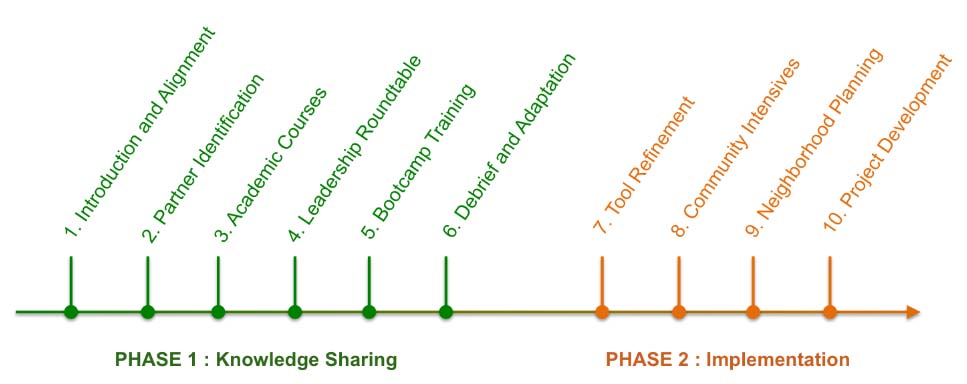
Art, Science, Action: Green Cities Re-imagined
Regularly, we feature a Global Roundtable in which a group of people respond to a specific question in The Nature of Cities.
show/hide list of writers
Hover over a name to see an excerpt of their response…click on the name to see their full response.
Pippin Anderson, Cape Town To think that one can turn a blind eye to the role of the different soil chemistry, atmospheric conditions of, or significant social presence in cities in exploring ecology in these spaces is naive.
Erik Andersson, Stockholm Ecology is framed by social dynamics, and anyone interested in more than ecological outcomes need to take the humans-in-nature approach to understanding ecological dynamics.
Marc Barra, Paris Urban ecology is an opportunity to reconnect people with nature.
Nathalie Blanc, Paris Our reading of urban ecology is based on the way in which the actors view their environment, according to political, scientific, and more largely cultural injunctions.
Marcus Collier, Dublin Urban ecology is vexing because it is fraught with emotion, opinion, value and fear. Urban ecology is a topsy-turvy world of contrasts.
Paul Downton, Melbourne The one thing that every ecologist should know is that the urban ecosystem is a designed system and an example of extended physiology at a very large scale.
Ana Faggi, Buenos Aires The principal aim of urban ecology is to make cities more livable and environmentally resilient, but this is not an easy task as the social sphere is always decisive.
Niki Frantzeskaki, Rotterdam Three elements are fundamental in the mindset of ecologists of the future, which is the current mindset of urban ecologists: asking different questions; curiosity in multi-disciplinary research; the courage to translate knowledge into policy.
Dagmar Haase, Berlin The more ecologists accept humans and society being part of urban ecosystems—and the complementarity of the social, ecological, and infrastructure-technical systems—the more sustainable and resilient we will be.
Steven Handel, New Brunswick I hope every ecologist will someday know that the structure and function of nature downtown are as interesting and valuable as that memory of nature at their childhood summer camp.
Nadja Kabisch, Berlin Cities are the foreground for experimenting with new approaches towards livability, sustainability and resilience; all of which are important parts of urban ecology.
Timon McPhearson, New York The next generation of ecologists should take a more inclusive definition of ecology: that ecosystems are social-ecological systems. It will help us improve management in all ecosystems, not only in urban areas.
Harini Nagendra, Bangalore We cannot be content only to study and to observe—we must simultaneously engage and act.
Steward Pickett, Poughkeepsie The single thing that ecologists in general should think of when they hear the term “urbanization” is that urban change is very much like the contemporary, dynamic view of community assembly they already know.
Philip Silva, New York Every ecologist should know that urban ecology is very closely related to the “sociology of scientific knowledge” when it starts asking questions about the production of knowledge used to manage urban ecosystems.
Mike Wells, Bath Urban ecology is a framework for exploration and expression of the multiple strategies and mechanisms for positive, creative and supportive interactions between human beings and the natural world.
Weiqi Zhou, Beijing Urban ecology acts as the frontier where ecologists can effectively promote the science-policy interface for local, regional, and global sustainability.
Timon McPhearson

about the writer
Timon McPhearson

Dr. Timon McPhearson works with designers, planners, and local government to foster sustainable, resilient and just cities. He is Associate Professor of Urban Ecology and Director of the Urban Systems Lab at The New School and Research Fellow at the Cary Institute of Ecosystem Studies and Stockholm Resilience Centre.

Introduction

An ecology for the Anthropocene

Urban ecology has expanded in the last couple decades as a major, global, interdisciplinary field that advances biodiversity, sustainability, and fundamental ecological research in the context of cities and urbanization. With all this accumulated learning, has urban ecology made its mark in the field of ecology more generally?
In some of the most important peer-reviewed ecology journals, and on social media, it seems even the most basic of urban ecology concepts have yet to be appreciated or incorporated in the broader ecology discipline. For example, it’s been 25 years since Humans as Components of Ecosystems was published, and yet many ecologists still don’t see humans as part of how we define and study nature—despite the fact that every ecosystem on earth is affected by, and has effects on, people.

The High Line in New York City. Photo: David Maddox

In November 2017, Nature Ecology and Evolution published a major review of the field of ecology, titled “100 articles every ecologist should read” (behind a paywall, unfortunately). It must be noted that the list was a product of a extensive survey of ecologists. Nevertheless, many ecologists around the world took exception to the lack of gender and racial diversity, and its general lack of inclusivity (see here, here, and here). Notably lacking from these academic discussions has been a recognition of core contributions from urban ecology to how we understand, manage, and plan ecosystems on our urban planet.

It begs the question: what would a reading list be for the discipline of ecology in the Anthropecene? But we are getting ahead of ourselves.

No one disputes that the 100 papers listed by Nature Ecology and Evolution are important in the history of ecology. Indeed, everyone should read these papers. But is this the right list of 100 papers to understand ecology today? There are other papers that should make a reading list for a complete understanding of modern ecology. An alternative version of a “key reading” prompt could be this: what are the 100 papers that every ecologist must read to understand ecology today, in the Anthropocene? Social ecology, biophilia, justice, poverty, gender, values, the Global South, design, climate change, policy; these are just some of the topics that are core material for understanding the broad science of ecology today, These topics are largely missing from the 100 papers list.

And also missing, of course, is urban ecology.

As it happens, urban ecology routinely includes the aforementioned list of additional topics: social ecology, biophilia, justice, policy, and so on. How does urban ecology advance the state of the art in ecology more generally? It advances our understanding of how our current world works, how it might work better, and it lays foundations to turn that learning towards pressing Anthropocene challenges, both urban and non-urban.

We asked a diverse group to help our non-urban ecological colleagues understand some of the most important contributions from urban ecology for advancing the field of ecology. We asked them this question: What is one thing every ecologist should know about urban ecology? (We asked them to suggest a reading also—a start on a reading list.)
Along the way, let’s expand the idea of “ecology”.

David Maddox

about the writer
David Maddox

David loves urban spaces and nature. He loves creativity and collaboration. He loves theatre and music. In his life and work he has practiced in all of these as, in various moments, a scientist, a climate change researcher, a land steward, an ecological practitioner, composer, a playwright, a musician, an actor, and a theatre director. David's dad told him once that he needed a back up plan, something to "fall back on". So he bought a tuba.

Pippin Anderson

about the writer
Pippin Anderson

Pippin Anderson, a lecturer at the University of Cape Town, is an African urban ecologist who enjoys the untidiness of cities where society and nature must thrive together. FULL BIO

Pippin Anderson

To think that one can turn a blind eye to the role of the different soil chemistry, atmospheric conditions of, or significant social presence in cities in exploring ecology in these spaces is naive.

Ecology in cities is always different to its rural counterpart, and as a result often requires a more creative approach to understanding. I think as long as ecologists try to do pure ecological research in cities, overlooking the presence, and role of, the large human populations that define these areas, will always render their findings problematic. There is that great article by Emma Marris, Ragamuffin Earth, where she presents an analysis of peer-reviewed journal articles and ‘outs’ ecologists who in fact work in, or in close proximity to, cities but fail to engage with the significant drivers pertinent to cities (https://www.nature.com/news/2009/090722/full/460450a.html). To think that one can turn a blind eye to the role of the different soil chemistry, atmospheric conditions of, or significant social presence in cities in exploring ecology in these spaces is naive.

Traditionally trained ecologists, and by that I mean those schooled in pure ecological theory and methods who have been ‘raised’ in pristine environments, are often challenged by the urban context. Here challenges abound. Reference sites are often lacking, sample size and replication constrained by the urban form, access and sampling hampered by safety or issues of social distrust. Field work entails navigating dogs, walls and fences, and budgeting for the fact that at least some field equipment will likely go missing or be vandalized. Ecological study in cities requires something of a maverick attitude. This is by no means to say one can abandon the underpinning requisites of good science, but a creative and adaptive approach needs to be drawn on. In addition to this, an ecologist working in a city must be willing to engage with people. Access at the least, and social insights and perceptions, as well as engaging with land managers are all parts of the study of urban ecology. In addition to these more formal engagements, any greenspace in a city is likely to produce curious citizens, homeless people, and wily children.

These are all elements which must be engaged with or at the very least anticipated, and if encountered, navigated. In my view these are the bits and pieces that make urban ecology fun, and keep us in a learning space; resisting dogged views and mantras. It is possible of course that there may be bits and pieces of remnant land in cities where the system is ticking along as it was before the settlement of the city and in which case that would be a fantastic find. But I would still argue that even if you carried out ecological research in a city and demonstrated that a system was entirely pristine or original in nature your research would still need to first ask “is this urban remnant patch akin to its rural counterpart?” The research would need to include all the relevant urban dimensions to be able to really confidently state this system is unaffected by the myriad of urban drivers. At that point a further interesting question would be “why?” and at that point you are back to doing urban ecology research again!

Suggested reading:
Marris, E. 2009. Ecology: Ragamuffin Earth. Nature 460: Pages 450-453. https://www.nature.com/news/2009/090722/full/460450a.html 

Erik Andersson

about the writer
Erik Andersson

Erik Andersson works as associate professor in sustainability science at the Stockholm Resilience Centre.

Erik Andersson

Ecology is framed by social dynamics, and anyone interested in more than ecological outcomes need to take the humans-in-nature approach to understanding ecological dynamics.

The one thing? For the sake of diversity I will choose one of the many things I believe that someone with an interest in ecology and its place in our cities would benefit from being familiar with. I have always had a liking for landscape approaches, especially when applied to cultural landscapes (and yes, cities are very definitely cultural landscapes)—they often combine solid ecological theory with an application where people and their activities are embedded parts. Understanding both the processes driving change and the implications of emergent patterns is essential—and this ideally at a scale where we can try to influence things (always attractive for the more action oriented among us).

To this point, I would suggest two publications: R.T.T. Forman’s Land mosaics from 1995. It offers a solid background to drivers of change and the patterns they create, and the latter key principles for assessing the ecological outcomes. Ecology is framed by social dynamics, and anyone interested in more than ecological outcomes need to take the humans-in-nature approach to understanding ecological dynamics. Understanding this cumulative effect of multiple, sometimes complex, factors is essential if we are to make sense of our cities. And perhaps make them better places.

Suggested reading:
Forman, R. T. T. (1995) Land mosaics. Cambridge, UK.: Cambridge University press.

Marc Barra

about the writer
Marc Barra

Marc Barra is an ecologist at the Regional Agency for Biodiversity in Paris Region in France, within the Institute of Planning and Urban Development of the Île-de-France. He is particularly interested in urban ecology and solutions to integrate biodiversity at the city, district and building scales.

Marc Barra

Urban ecology is an opportunity to reconnect people with nature.

Despite warnings about the state of the planet’s health, ecology lacks recognition and is hardly known as a discipline in its own right. Furthermore, among the ecologist community, urban ecology struggles to find a place. Yet I consider it to be one of the most promising disciplines in our century, when nearly 50% of the population lives in cities and urbanization greatly affects biodiversity.

The one thing that every ecologist should know about urban ecology is that it gives ecology—often perceived negatively—a concrete project and useful applications for the people. Urban ecology has the potential to reconcile cities and their inhabitants with biodiversity. Urban ecology provides our society with solutions, all for better health and a better living environment. I like urban ecology because it is experimental, because it requires interdisciplinary knowledge, because it is uncertain and at the same time, it is a “no-regrets” ecology: increasing biodiversity and reclaiming ecosystems it cannot be worse than not doing it! Urban ecology takes its inspiration in nature: we say “nature-based solutions” for preserving, reclaiming and managing functional ecosystem in order to mitigate climate change and adapt to its effects (storms, floods, dryness, heat waves).

Urban ecology has a wide scope of applications from the building scale to the whole city. Urban ecologist can work together with city gardeners to create ecologically-designed and managed green spaces (zero pesticide, no-mowing policy, etc.). Urban ecologist are also working with city planners and urbanists to find space for ecological corridors in planning documents. At the district level, many solutions are being created by land developers and urban ecologist to create “sponge cities”, using soils as natural filters, and bioswales, rain gardens or phyto-purification basins. Under our feet, the challenge of urban soil rehabilitation is so important. Many research projects try to understand the role of urban soils and encourage “depaving” policies or phyto-remediation for polluted soils. Urban agriculture within community gardens is also an opportunity to enhance nature spaces, even cultivated, in urban areas. At the building level, a wide range of solution has emerged over the last few years to promote green architecture:  green roofs and green living walls are becoming smart solutions to increase biodiversity while reducing urban heat effect and storing more rainwater. Some researchers try to understand how these new ecosystems can contribute to restoring ecological connectivity within cities as well as being new habitats for wildlife.

One of the challenges of smart green cities is to switch from grey to green infrastructure. So far, cities have always used civil engineering techniques largely based on “gray” systems that consume a lot of non-renewable resources and emit pollutants (CO2, NOx) involved in climate change. Green infrastructure based on urban ecology knowledge has reduced the urban environmental footprint and is cost efficient.

Urban ecology is an opportunity to reconnect people with nature. In the next years, citizen science programs or participatory events should play a major role in cities for the success of urban ecology.

Suggested reading:
Dusza, Y.,  S. Barot, Y. Kraepiel, J-C. Lata, L. Abbadie, and X. Raynaud. 2017. Multifunctionality is affected by interactions between green roof plant species, substrate depth, and substrate type. Ecol Evol. 7:2357–2369. https://doi.org/10.1002/ece3.2691

Nathalie Blanc

about the writer
Nathalie Blanc

Nathalie Blanc works as a Research Director at the French National Center for Scientific Research. She is a pioneer of ecocriticism in France. Her recent book is Form, Art, and Environment: engaging in sustainability, by Routledge in 2016.

Nathalie Blanc

Our reading of urban ecology is based on the way in which the actors view their environment, according to political, scientific, and more largely cultural injunctions.

Since Rio in 1992, urban ecology has developed in three stages: a first step was built around the ideas of transversality of public action, and research grappling with issues of complexity and systemic thinking. The public policies and the urban ones were then sectorized, to the point of developing specialized and non-transversal actions. Research focused on environmental problems in terms of solutions. Today, we see a third phase of public action in environmental matters with a re-territorisalisation of issues and modes of governance around the management of territories. This, above all, represents the exploitation of urban nature considered, in most cases, primarily in productive terms. Nature is put to work, whether it is sewage treatment, agricultural yield, or green roofing, to name just a few examples. Nature is thus called upon to render services. This vision forgets the ecosociosystemic complexity of the human and non-human living.

In truth, we can speak of “locking” when it comes to urban ecology: a set of articulated operating regimes lock a trajectory, condemn to insignificance any possibility of creating other relationships (Stengers, 2014). Thus if it seems that lifestyles are taken into account though works of prospective, they are often not in sync with the current preference for techno-centered solutions in urban planning, and only at the margins address the broader questions of society beyond individuals and consumers needs. How do we strengthen the dynamic for moving toward of adapting populations, collectives and individuals? How to take into account the infinitesimal choices that weave ordinary lives, in the sense of creating an ecological transformation? Finally, how can one account for the dynamics tending to distribute “agencies”, that is, the power to act, to the elements of nature-culture, be they plants, animals, or elements of the substratum? Our reading of urban ecology is based on the way in which the actors view their environment, according to political, scientific, and more largely cultural injunctions.

Suggested reading, in French and English:
Isabelle Stengers, Une autre science est possible ! Manifeste pour un ralentissement des sciences, Paris, Les empêcheurs de penser en rond – La Découverte, 2013.

Braidotti, R. 2013. The Posthuman. Cambridge : Polity Press.

Marcus Collier

about the writer
Marcus Collier

Marcus is a sustainability scientist and his research covers a wide range of human-environment interconnectivity, environmental risk and resilience, transdisciplinary methodologies and novel ecosystems.

Marcus Collier

Urbanised, novel ecosystems, replete with a plethora of urban-adapted species, escaped garden plants, remnants of the past, and unusual species associations, tell us quite a lot about ecological processes in general.

There are so many things that ecologists don’t yet know about urban ecology, none the least of which is the very real likelihood that there is no longer a distinction between what is urban and what is not! The urban landscape is itself an ecosystem, within which there are diverse habitats not too dissimilar in form and function to their wilder, distant counterparts. Can we distinguish between the urban and the urbanising? But that debate is for another day!

Personally, I love urban habitats and urbanised / urbanising species. They are truly resilient; having rapidly and efficiently adapted to the relentless, unsettling pace of human progress. We hear of novel, mongrel, hybrid, chance, unplanned, brownfield habitats. We hear of chance discoveries of rarely seen species and plagues of all-too-often seen species. We marvel to see certain iconic species in cities that we don’t get to see in the wild, we revile at many others. Urban ecology is vexing because it is fraught with emotion, opinion, value and fear. Urban ecology is a topsy-turvy world of contrasts. While scientists will often agree that it is difficult to do urban research (in any field, not just ecology), it can also be very revealing and sometimes wonderful to explore.

For me, what every ecologist needs to know about urban ecology is that urbanised, novel ecosystems, replete with a plethora of urban-adapted species, escaped garden plants, remnants of the past, and unusual species associations, tell us quite a lot about ecological processes in general. However, perhaps they go further and tell us so much more about ourselves, our society, our crazy values, our attitudes and emotions, and what we think of as progress. Urban ecology is the study of the palimpsest. It provides us with glimpses of the past, snapshots of the distant, and potential directions for the future.

Paul Downton

about the writer
Paul Downton

Writer, architect, urban evolutionary, founding convener of Urban Ecology Australia and a recognised ‘ecocity pioneer’. Paul has championed ecological cities for years but has become disenchanted with how such a beautiful concept can be perverted and misinterpreted – ‘Neom' anyone? Paul is nevertheless working on an artistic/publishing project with the working title ‘The Wild Cities’ coming soon to a crowd-funding site near you!

Paul Downton

There are Brains in the Urban Ecosystem

The urban ecosystem is a designed system and an example of extended physiology at a very large scale.

It is difficult to hazard any sense of optimism about our cities when times are such that “To be aware of the wonders of the living planet is to take on an unbearable burden of grief.” The urban world is more commonly regarded as a blight on the planet than a wonder and offers countless examples of burdensome human behaviour but if we can’t unearth beauty and purpose in its Frankenstein ecology then how can we hope to place our cities “in balance with nature”? Humans are now collectively one of the largest forces in the biosphere and nowhere is our perverse exercise of that power more evident than in the morphology and metabolism of our urban systems.

Barry Commoner’s first law of ecology is that “everything is connected to everything else”  and it’s one of those statements of the obvious that wasn’t obvious to a lot of people until he said it. Another obvious fact that doesn’t have anything like the same degree of familiarity is the connected (of course) idea that the built environment is an extension of human physiology in the same way that termite mounds are extensions of termite physiology. Where does an organism stop and its environment begin? In The Extended Organism, J. Scott Turner describes how structures made by animals are “the agents whereby organisms adaptively modify flows of matter and energy through the environment.” And how structures like termite mounds, which transform wind energy to serve their termite colonies, are examples of organisms co-opting the environment “into a physiology that extends well beyond their conventionally defined boundaries”. Which is what humans do. It’s what our cities do. Humans modify their environment to make it more suitable for humans. The ability to make shelter is a fundamental requirement for human survival. It is much easier for social creatures like humans to build shelter together, rather than as individuals. Even if an individual was able to make useful shelter through their own efforts, they would still be relying on collectively generated knowledge and most likely collectively developed and manufactured tools. The most simple human settlement is a result of complex interactions between multiple individuals and the end result of their efforts is a means of co-opting and modifying their environment to improve their chances for survival.

In considering the ecology of urban systems it should perhaps be considered that all human settlement is fundamentally about extending the capacity and resilience of human physiology through environmental means and our present-day urban ecologies are extraordinary but flawed attempts at maintaining homeostasis to sustain life.

In The Tinkerer’s Accomplice, Turner continues his exploratory thinking to show “How design emerges from life itself.” After a while you begin to see how the human impulse to design may be an evolutionary result of a basic need to modify our environment in order to survive. I can’t identify just one paper in particular that explores the idea, but I would argue that the one thing that every ecologist should know is that the urban ecosystem is a designed system and an example of extended physiology at a very large scale. Now that this human device is affecting the entire planet it is clear that because consciousness and the propensity of humans to design and manipulate the environment for their own benefit is integral to the function of urban ecosystems, they should be abiding concerns for any ecologist.

Suggested reading:
Turner, J. Scott. 2010. The Tinkerer’s Accomplice: How Design Emerges from Life Itself. Harvard University Press. 304 pages. http://www.hup.harvard.edu/catalog.php?isbn=9780674057531

Ana Faggi

about the writer
Ana Faggi

Ana Faggi graduated in agricultural engineering, and has a Ph.D. in Forest Science, she is currently Dean of the Engineer Faculty (Flores University, Argentina). Her main research interests are in Urban Ecology and Ecological Restoration.

Ana Faggi

The principal aim of urban ecology is to make cities more livable and environmentally resilient, but this is not an easy task as the social sphere is always decisive.

When an area is urbanized, important transformations take place in soils, climate, water bodies and native biota. So far, nothing new for an ecologist that understands that any biotic or abiotic disturbance can trigger changes in the geochemical cycles and in the assemblages of species.

The consequences of city sprawl on the urban ecosystem`s resilience are long-lasting and in most cases irreversible, just as it happens in Nature:  think of the destroying effects that a hurricane or a devastating fire may have on a coastal ecosystem or on a forest.

Most theoretical concepts of classic ecology that deal with populations, communities, ecosystems and landscapes are applicable to cities; from viability, niche theory, density dependence, succession, interspecific relationships, gain and loss of species, intermediate disturbance, to island theory, edge effects, corridors, significance of habitat heterogeneity, and even the tragedy of the commons.

But the urban ecosystem is a very special one. It is comprised of physical, ecological and social spheres. In the city, humans are the dominant species. Their decisions in city planning and management may make it intricate for the different components to reach a new ecological balance. Cities differ in traditions, history, economic and political power. Because of these socio-cultural characteristics it is more difficult to develop a consistent general theoretical framework.

To get into the subject, and develop an understanding of the cross-disciplinary nature of urban ecology, every ecologist should first read Pickett and Cadenasso (2017) How many principles of urban ecology are there?.

One of the most applied theories in urban ecological studies is the gradient theory of Mc Donnell and Pickett (1990), recognizing general ecological patterns from the city center to the peripheries. Nevertheless, the theory does not always work in cities where growth is poorly planned such as in Latin America, suggesting the need for more local studies.

What every ecologist should know about urban ecology is that it is mainly an applied discipline where human needs and impacts on the ecosystem are integral parts to solving problems. It principal aim is to make cities more livable and environmentally resilient but this is not an easy task as the social sphere is always decisive.

Most of these problems are wicked ones: difficult to solve because of incomplete, contradictory and changing requirements. Because they are interdependent, socially complex, and involve behavioral changes, an interdisciplinary approach that goes beyond ecology is the only way out.

Suggested reading:
Mc Donnell, M. J. and Pickett, S. T. A. (1990) The study of ecosystem structure and function along urban-rural gradients: an unexploited opportunity for ecology. Ecology 71,1231–1237.

Dagmar Haase

about the writer
Dagmar Haase

Dagmar Haase is a professor in urban ecology and urban land use modelling. Her main interests are in the integration of land-use change modelling and the assessment of ecosystem services, disservices and socio-environmental justice issues in cities, including urban land teleconnections.

Dagmar Haase

The more ecologists accept humans and society being part of urban ecosystems—and the complementarity of the social, ecological, and infrastructure-technical systems—the more sustainable and resilient we will be.
The one thing every ecologist should know about urban ecology is the role humans play in social-ecological systems which cities are. Even more important is to acknowledge the role of humans and society in past and future dynamics of social-ecological systems. Ecologists have great ideas on how to identify and to explain the role of humans in ecosystem functioning, stability and change. But it is only together with the work of social scientists and economists are they able to understand the magnitude and direction of change to the environment and ecosystems on the one hand, and their impacts on humans, their socio-economic well-being, and the associated short- and long-term.

Ecologists have to acknowledge and to know that society is shaping patterns and flows in urban ecosystems, and that green, blue, and grey are complementary to providing for human well-being. Co-evolution and co-development is thoroughly existing and evident in cities, thus if urban ecologists would know one thing about urban ecosystems, this is it: Humans and nature share the same habitat and they share it together—the more readily ecologists accept humans and society being part of urban ecosystems and the more actively they accept the complementarity of the social, ecological, and infrastructure-technical systems, the more sustainable and resilient our co-evolution will be.
Suggested reading:
Alberti, M. 2015. Eco-evolutionary dynamics in an urbanizing planet. In Trends in Ecology & Evolution. 30:2, pages 114-126. http://www.cell.com/trends/ecology-evolution/fulltext/S0169-5347(14)00249-3

Niki Frantzeskaki

about the writer
Niki Frantzeskaki

Niki Frantzeskaki is a Chair Professor in Regional and Metropolitan Governance and Planning at Utrecht University the Netherlands. Her research is centered on the planning and governance of urban nature, urban biodiversity and climate adaptation in cities, focusing on novel approaches such as experimentation, co-creation and collaborative governance.

Niki Frantzeskaki

Three elements are fundamental in the mindset of ecologists of the future, which is the current mindset of urban ecologists: asking different questions; curiosity in multi-disciplinary research; the courage to translate knowledge into policy.

Every ecologist should know that urban ecosystems evolve and relate to the community/society that lives, being maintained and relates to them. Urban social-ecological systems are coupled, meaning that are interrelated and erosion of social conditions and the institutions therein manifest in unprotected, and unrestored urban ecosystems as. And in turn, deteriorating or unhealthy urban ecosystems do not allow for human to nature relations and fail to support human wellbeing, resulting in depriving urban environments for humans.

For this interrelationship to be balanced and ensure mutual benefits, adaptive institutions that guide open, innovative governance for healthy resilient urban socio-ecological systems are very important. Dividing (1) understanding in how urban ecosystems function and benefit humans from (2) understanding how institutions and governance processes that ensure a human-nature relation creates chasms in knowledge and misfit knowledge for urban planning and policy. What therefore every ecologist should know about urban ecology is that he/she needs to be open to interdisciplinary collaborations with social and political scientists for making knowledge of urban ecology relevant and actionable for better institutions and good governance to be realized in cities. He/She needs to recognize not the limits to his/her knowledge but the opportunities to research, learn and apply knowledge in collaborative and co-creative ways (involving also citizens and urban communities) for progressing urban science on socio-ecological systems. It is about the way knowledge is acquired that is changing and how it becomes socially and policy relevant and actionable that changes the role and the skills required for ecologists to “know about urban ecology”.

Three elements are fundamentals in the mindset of ecologists of the future: first, openness in asking different questions and asking questions differently to allow for interdisciplinary inquiry to be relevant; second, curiosity in engaging in multi-disciplinary research processes and learn from them; and third, the courage and passion to translate knowledge on urban socio-ecological systems for policy and society to act upon restoring and protecting urban ecosystems. The ecologists of future cities work in teams, learn from and with other scientists and communities, recognize the value of the discovery of knowledge and of making knowledge actionable for policy and community to pursue livable, just, resilient and sustainable cities.

Suggested reading:
Frantzeskaki, N., and Kabisch, N., (2016), Designing a knowledge co-production operating space for urban environmental governance – Lessons from Rotterdam, the Netherlands and Berlin, Germany, Environmental Science and Policy, 62, 90-98.

Steven Handel

about the writer
Steven Handel

Steven Handel is a restoration ecologist and the director of the Center for Urban Restoration Ecology (CURE), an academic unit at Rutgers University.

Steven Handel

I hope every ecologist will someday know that the structure and function of nature downtown are as interesting and valuable as that memory of nature at their childhood summer camp.
I think most people think that nature, ecology, is where we go when you want to get away from our frantic lives in urban centers. Similarly, adding ecological habitats into urban parcels is so often considered a romantic gesture, a Walt Disney-style decoration. I always want to remind ecologists that for all our affection for the wild places on Earth, it is our metropolises, our most densely populated areas, where ecology is most valuable to people.
Ecological services are well understood to advance human health and happiness. I am sure that is true whether one is in New York’s Times Square or Yosemite Valley in California. But, if one integrates the value of some trees to clean the air with the density of people around those trees, the value of that planting enhancement is magnified by the number of people nearby who will experience less respiratory distress. A line of trees improves the microhabitat for thousands of people on this city street, but only the occasional hiker in that pristine mountain valley. Think of a shade structure, such as tree canopy, in a quiet rural hot spot. The occasional person who passes by gets relief from the brutal sun. Whoopee-do. But, if we put that shade structure near a constant line of commuters or laborers, the value of the local shade is multiplied by the density of people that experience it. It is urban centers where ecological structure has most value to the human population. We must talk about this constantly with decision-makers in our cities.

Planning to enhance ecological features in cities often gets push back from people who define nature as a rural feature and thus inappropriate in a commercial zone. It is certainly true that a hectare of landscape pays less property tax than a strip mall or high-rise; its values don’t usually appear on a municipal balance sheet. But people who are oblivious to the concept of ecological services can be educated, understanding can be enhanced, and urban ecology can eventually be celebrated. Attitudes change. Thousands of people who once considered aluminum cans and bottles as garbage now define them as recyclable resources. People who today see a patch of woodlands as “empty space” can learn the new taxonomy of valuable ecological structure.

Many urban designers and planners today are learning how to include ecological structures and function into their work. Through new curricular offerings and the action of many public groups and media outreach, such as TNOC, new design renderings and criteria are more frequently including ecological features. There is a slow moving increase in the expression of urban ecology in designs, which I believe will become the new normal.

Many public and private land managers/clients have become aware of and are requesting ecological zones in cities. We must continue to stress the real value of these ecological parcels in the mosaic of city plans. The ecological spaces have value beyond the aesthetic aspects of nature that most city slickers see and will someday insist upon. I hope every ecologist will someday know that the structure and function of nature downtown are as interesting and valuable as that memory of nature at their childhood summer camp.

Suggested reading:
Elmqvist, T., Setälä, H., Handel, S.N., van der Ploeg, S., Aronson, J., Blignaut, J.N.,
Gómez-Baggethun, E., Nowak, D.J., Kronenberg, J., and de Groot, R. 2015. Benefits
of restoring ecosystem services in urban areas. Current Opinion in Environmental
Sustainability 14:101-108.

Nadja Kabisch

about the writer
Nadja Kabisch

Nadja Kabisch holds a PhD in Geography. Her special interest is on human-environment interactions in cities taking co-benefits from nature-based solutions implementation for human health and social justice into account.

Nadja Kabisch

Cities are the foreground for experimenting with new approaches towards livability, sustainability and resilience; all of which are important parts of urban ecology.

In a tele-connected world, ecosystems are increasingly interacting with social systems—most obviously in urban areas. In the Anthropocene, cities are the primary human habitat and in the demand to deal with social-ecological transformations. Given the current global changes of climate change and urbanisation, and their associated effects on natural systems, social systems and their interactions worldwide, cities are the foreground for experimenting with new approaches towards livability, sustainability and resilience; all of which are important parts of urban ecology.

With increasing densification, loss of open spaces, the environmental burdens of air pollution, noise and heat, developing and maintaining the ecosystems are increasingly important in urban areas. To increase knowledge about the quantity and quality of benefits that urban residents may gain from ecosystems is to increase their quality of life, health and well-being. All known as ecosystem services, understanding their function necessitates interdisciplinary research in urban ecology which bridges knowledge from natural and social science. Even more, the recent scientific advances to include transdisciplinary approaches to interdisciplinary projects opens the field of urban ecology for assessing the implementation of socio-ecological, governance and technical innovations in terms of planning approaches, governance modes and policy experiences across disciplines, policy domains and governmental departments.

I believe that taking an inter-and transdisciplinary social-ecological systems approach to cities, and assessing how urban ecosystem services are provided to city residents in quantity and quality, are important parts of urban ecology to understand social-ecological transformations under global challenges of climate change and urbanisation. This goes hand in hand with potential new avenues for governing and managing urban systems in a knowledge co-production operating space in which scientists, urban planners, policy officers or practitioners can learn from each other and establish relationships and trust in mutual dialogues to find solutions to environmental problems for increasing resilience and sustainability in urban areas (Frantzeskaki et al., 2016).

Suggested reading:
Frantzeskaki, N., Kabisch, N., McPhearson, T. (2016) Advancing urban environmental governance: Understanding theories, practices and processes shaping urban sustainability and resilience. Environmental Science and Policy, 62, Special Issue, Pages 1-144.

Timon McPhearson

about the writer
Timon McPhearson

Dr. Timon McPhearson works with designers, planners, and local government to foster sustainable, resilient and just cities. He is Associate Professor of Urban Ecology and Director of the Urban Systems Lab at The New School and Research Fellow at the Cary Institute of Ecosystem Studies and Stockholm Resilience Centre.

Timon McPhearson

The next generation of ecologists should take a more inclusive definition of ecology: that ecosystems are social-ecological systems. It will help us improve management in all ecosystems, not only in urban areas.

 It has been 25 years since Humans as Components of Ecosystems (McDonnell and Pickett 1993) was published, so it is a bit shocking to think that decades of research linking social and ecological systems is not part of the main stream of what every ecologist should know. Of course, urban ecology goes back much further to Herbert Sukopp’s work in Berlin post-World War II (Sukopp 2008) and to early Chinese scholars even earlier working on integrating ecosystems into urban life (Wu 2014).

McDonnell and Pickett’s book was seminal to launching urban ecology in the US. Urban ecology is fundamental social-ecological systems research intended to open the eyes of all ecologists to the fact that every ecosystem on earth has human drivers, influence, and impacts on both structure and function of the system. Ecologists of every stripe must fundamentally understand that humans are not somehow outside the domain of ecology. In Europe, China and elsewhere, there is a wide embrace of ecosystems as being fundamentally social-ecological systems (Niemela et al. 2011). Translation: humans are part of ecosystems, and humans and other biophysical components of ecosystems are deeply intertwined, with reciprocal influence. There is not an ecosystem on earth that does not have human influence. It feels like going back to basics to argue this point, and yet if there is one thing all ecologists must realize, it is that to study ecology in the Anthropocene, on this urban planet, we must consider ecosystems now as not simply biophysical systems somehow operating in a closed box without human interaction. That box must be opened to link exogenous drivers like climate change but also direct endogenous human actions.

It is an unnecessary, biased, and even counterproductive approach to define what is important in ecology as somehow distinct from the human dominated natural world. Ecosystems do not exist in a biophysical vacuum. Ecosystems exist in the Anthropocene like the rest of us and humans are part of these systems exerting influence on them and affecting fundamental ecological processes. The broader ecology field must recognize that social-ecological system research is an area of study that has made significant advances in how we think about, study, and manage ecosystems in urbanizing and human-dominated socio-ecological contexts all over the world (Vitousek et al. 1997; Grimm et al. 2008). Ecology cannot afford to completely miss the Anthropocene context that all ecosystems exist in, nor the enormous potential that lies in reflexive and respectful human-nature interaction (Alberti et al. 2003).

Urban ecology is a field that is expanding rapidly (McPhearson et al. 2016). The next generation of ecologists should be encouraged, not discouraged, from taking a more inclusive definition of ecology where ecosystems are social-ecological systems which can help us improve management in all ecosystems, not only in urban areas. ­This is a fundamental step to advancing ecology as a source of knowledge that can help shift the needle on some of the most important challenges we face, from climate change, to environmental injustice and pollution, to social inequality in access to health and well-being benefits ecosystems in and outside of cities provide.

Suggested reading:
McDonnell, M., and S.T.A Pickett. 1993. Humans as Components of Ecosystems: The Ecology of Subtle Human Effects and Populated Areas. Springer-Verlag New York, Inc.

Harini Nagendra

about the writer
Harini Nagendra

Harini Nagendra is a Professor of Sustainability at Azim Premji University, Bangalore, India. She uses social and ecological approaches to examine the factors shaping the sustainability of forests and cities in the south Asian context. Her books include “Cities and Canopies: Trees of Indian Cities” and "Shades of Blue: Connecting the Drops in India's Cities" (Penguin India, 2023) (with Seema Mundoli), and “The Bangalore Detectives Club” historical mystery series set in 1920s colonial India.

Harini Nagendra

We cannot be content only to study and to observe—we must simultaneously engage and act.

Over the 25 or so years that I have worked in the area of ecology, I have been privileged to witness an overall transformation of the discipline, from one that was overwhelmingly interested in “pure” evolutionary and ecological processes in “pristine” areas (i.e. areas where there was no obvious human footprint), to a field that now recognises the ubiquity of human-nature interaction—embracing social-ecological approaches to frame, investigate, interpret and intervene in issues of ecology and conservation. Thus, for instance, while many ecologists once believed that protected areas should be kept isolated from people, we now overwhelmingly recognise the role that so many indigenous communities have played in creating specific ecologies unique to many protected landscapes across the world.

Yet cities remain a particular blind spot for many ecologists—though the field of urban ecology has grown almost exponentially in recent years. Urban systems are arguably one of the most human-dominated of all ecosystems, and it is practically impossible to conduct studies on “pure” ecological or evolutionary processes in a city without acknowledging the role of people. Social-ecological framing lies at the heart of urban ecological research, and this is something that most traditional schools of ecology, across the world, continue to be uncomfortable with.

What should every ecologist know about urban ecology? They need to know that the urban now affects every part of the world—however distant, or seemingly pristine. It is futile, indeed impossible to study ecology in isolation from the human thought processes, industrial systems, cultures of consumption, and teletransfers of money and data that imply the urban. But this does not mean that ecology and conservation are doomed—quite the contrary, ecology has entered a most exciting period of knowledge discovery. The interconnectedness of cities, culture and nature requires collaborations between ecologists, economists, social scientists and scholars of the humanities to advance the frontiers of knowledge. And, given the speed at which things are changing, we cannot be content only to study and to observe—we must simultaneously engage and act, which demands further collaborations between scientists, practitioners, city government, activists, and regular citizens—all too often, one of us carries these various categories within ourselves as well, wearing multiple hats!
Thus, at times, I am an urban ecologist, at others I am a mother of a child who loves her local park and lake, the daughter of another mother who is a fierce proponent of urban nature, as well as an educator, an activist, and a neighbour with different—but equally compelling responsibilities to society, community, nature and city. All of us carry these multiple identities within us. Within or outside, we need multiple perspectives for urban ecology to flourish—the knowledge of a street vendor who spends decades selling flowers under a Ficus tree canopy is of as much value as that of a rag picker who keeps the city clean by recycling its trash, and the insights of a cattle grazer who has seen a healthy lake transform into a polluted mess are as important as that of an urban ecologist studying surface water hydrology.

In short, urban ecology can bring much to an ecologist in terms of insights into the interconnectedness of everything—nature, culture, and concrete. For me, at least, this is what it has brought over time—and the complexity is at once humbling and deeply fascinating and educative.

Suggested reading:
Elmqvist, T., M. Fragkias, J. Goodness, B. Guneralp, P.J. Marcotullio, R. I. McDonald, S. Parnell, M. Schewenius, M. Sendstad, K.C. Seto, C. Wilkinson, Eds. 2013. Urbanization, Biodiversity and Ecosystem Services: Challenges and Opportunities: A Global Assessment. Springer Netherlands. 755 pages. https://link.springer.com/book/10.1007%2F978-94-007-7088-1 

Steward Pickett

about the writer
Steward Pickett

Steward Pickett is a Distinguished Senior Scientist at the Cary Institute of Ecosystem Studies in Millbrook, New York. His research focuses on the ecological structure of urban areas and the temporal dynamics of vegetation.

Steward Pickett

One Thing That All Ecologists Should Know about Urban Ecology

The single thing that ecologists in general should think of when they hear the term “urbanization” is that urban change is very much like the contemporary, dynamic view of community assembly they already know.

Urbanization is like succession: It doesn’t have a single pathway; it doesn’t have a single end point; it influences all ecological systems; and it results from a continuous interaction of migrations, extinctions, interactions, and accidents.

Succession is one of ecology’s oldest ideas. But in its contemporary form, it is poorly appreciated. Too often, it is summarized as the old textbook generalization, involving facilitative species replacement, a regular sequence of dominants, and ending with a stable community. This textbook rendition has fortunately been replaced over the one hundred-year history of the discipline. (Frederic Clements’ magisterial but flawed book that first codified succession theory was 100 years old in 2016.) So succession, or if you prefer, community dynamics or community assembly, now is the epitome of a contingent, dynamic process conditioned by fluxes of organisms, resources, disturbance, and stressors across complex landscapes.

Urbanization can be considered similarly to the evolution of successional thinking. It used to be that urbanization was defined simply as conversion of rural, pastoral, forest, or wild lands to urban cover. That is, urbanization produces cities and towns. The subsequent trajectory following conversion was modeled on North temperate cities that “developed” through the industrial revolution, often changing from focus on natural resource commodification, to industrial production, to sanitary engineering, and finally to post-industrial service. This is urbanization like Clementsian succession. It is directional, step-wise, and terminates in some sort of “advanced” stage. It is also implicitly universal, with all cities following the same logic. Urbanists will immediately see the flaws in this analogy with classical succession. But the similarities with contemporary thinking about succession or community assembly may actually be useful in urban ecology itself, as well as helpful in linking urban ecology with the ecology in general.

If we hypothesize that urbanization and succession are conceptually analogous, the following principles can help guide research and comparison:

  • Urbanization doesn’t have a single pathway. This is especially clear in countries or regions that are only recently industrialized. Even more pointedly some regions have become “cities of consumption” without passing through an industrial or a sanitary state. China, India, and countries in Africa, for example exhibit distinctive trajectories of urban change.
  • Urbanization isn’t only unidirectional. Within urban regions, there are places that grow, and places that thin out. Change in cities, towns, and their connected regions is patchy, just as heterogeneous ecological mosaics of any type can be. Treating urban change as a “red blob” that continuously spreads across a region is one model of urbanization, but it is one that ignores important internal dynamics.
  • Urbanization, like succession, is everywhere. Urbanization isn’t just the production of cities. Urban conditions influence both nearby and distant ecosystems. They do so by distal changes in livelihoods, lifestyles and consumption choices, investment shifts influencing both hinterlands, wild places, and central cities, and infrastructural diffusion across broad regions. The percentage of land covered by cities and towns is a poor index of urban influence in regions and the world.
  • Urbanization, like biotic community assembly, reflects a multitude of interacting processes, influences, and “actors” (that is, species, social groups, institutions, environmental changes, etc.). The complexity of ecologically familiar processes such as feedbacks, priority effects, spatial legacies, indirect effects, natural disturbances, and social perturbations, combine to make urbanization a contingent process. Some drivers will be intentional, and some with be accidental.

The single thing that ecologists in general should think of when they hear the term “urbanization” is that urban change is very much like the contemporary, dynamic view of community assembly they already know.

Suggested reading:
McHale, M. R., S. T. A. Pickett, O. Barbosa, D. N. Bunn, M. L. Cadenasso, D. L. Childers, M. Gartin, G. R. Hess, D. M. Iwaniec, T. McPhearson, M. N. Peterson, A. K. Poole, L. Rivers, S. T. Shutters, and W. Zhou. 2015. The new global urban realm: complex, connected, diffuse, and diverse social-ecological systems. Sustainability 7:5211–5240.

Philip Silva

about the writer
Philip Silva

Philip's work focuses on informal adult learning and participatory action research in social-ecological systems. He is dedicated to exploring nature in all of its urban expressions.

Philip Silva

Every ecologist should know that urban ecology is very closely related to the “sociology of scientific knowledge” when it starts asking questions about the production of knowledge used to manage urban ecosystems.

Every ecologist should know that urban ecosystems are, in large part, shaped, structured, and governed by human activity. That much seems obvious—but still worth unpacking for a moment before getting to the one thing I believe every ecologist should know about urban ecology. Some cities are home to patches of landscape that seem untouched by urban development. The municipal park system here in New York City, for example, boasts more than 10,000 acres of grasslands, forests, and wetlands designated as “natural areas”—little bits of Eden that offer an escape from the bright lights of the big city. Yet these natural areas are often manipulated and managed with the same purposeful intensity as any of New York’s hundreds of community gardens, tens of thousands of acres of landscaped parks, and hundreds of thousands of street trees. It takes real human effort to manage even the most “natural” of natural areas, not to mention all the other manicured greenery on offer in a place like New York City. And it takes a working knowledge of urban ecosystems and their many components to guide those efforts. Human knowledge, then, is itself an element of urban ecosystems, and it follows that the social process of creating, codifying, contesting, sharing, and applying that knowledge can be an object of urban ecological research.

So, here’s my main point: every ecologist should know that urban ecology is very closely related to “sociology of scientific knowledge” when it starts asking questions about the production of knowledge used to manage urban ecosystems. Where does the knowledge to manage urban ecosystems come from? A good deal of it likely results from “pure” or “basic” scientific research. Ecologists publish peer reviewed journal articles and well-informed managers read, interpret, and apply that knowledge in practice. Yet urban ecology is a young field of inquiry. Sometimes the knowledge needed for day-to-day management is missing from the scholarly literature. In these cases, professional managers and volunteer stewards construct knowledge outside the bounds of formal science. They may create useful and reliable knowledge through iterative cycles of adaptive management, making incremental changes in practice and collecting data on the outcomes to inform gradual changes in their work over and over again. Or, just as likely, they may create knowledge-in-practice without any use of formal data collection or monitoring, building up storehouses of knowledge about effective practice through daily observations of trial and error. The methods of surfacing and studying these knowledge-making practices—through formal science, through adaptive management, or through communities of practice—should be part of the urban ecology research toolkit, and every urban ecologist should have at least a passing familiarity with the concepts behind those methods.

Suggested reading: Pickering, Andrew. “Chapter One: The Mangle of Practice.” In The Mangle of Practice: Time, Agency, and Science, 1–34. Chicago: University of Chicago Press, 2014.

Mike Wells

about the writer
Mike Wells

Dr Mike Wells FCIEEM is a published ecological consultant ecologist, ecourbanist and green infrastructure specialist with a global outlook and portfolio of projects.

Mike Wells

Urban ecology is a framework for exploration and expression of the multiple strategies and mechanisms for positive, creative and supportive interactions between human beings and the natural world.

The one thing that every ecologist should know about urban ecology is that it can provide us with the tools we need to inspire mankind the consumer to save global biodiversity. It can provide the wisdom to help us fulfil a pressing duty as human beings and stewards of the natural world.

By understanding the intense interactions between human and non-human possible in the urban realm and the particular impacts that these can have to those in ‘nature deficit’ we have an opportunity to reinvigorate, rekindle and super-develop the oft -diminished sense of excitement and amazement that we can feel when we experience other species with which we share this fragile planet—species which we are wantonly, systematically and oh-so rapidly wiping out. In the urban realm we have a ‘captive’ audience—and a very large one—one in regular attendance. One that passes habitats, features and installations sometimes several times a day and draws meaning and wisdom from them directly and indirectly. We can welcome nature actively in new (re)combinations and often strengthen its populations to sally forth into the surrounding denuded and sprayed-out countryside. We can supersize it, display it, give it precedence, celebrate it, place it under the lens at the doorstep of every citizen regardless of income and advantage. We can graphically, artistically and eye-catchingly illustrate its wider global destruction and deterioration, explaining the rates of change in myriad ways, artistic and technological for mass public view. We can illustrate how our consumerism is driving these losses.

All the things that nature does for us in urban and rural areas are vitally important and can nurture respect and interest. But without deep love and wonder at the bizarre, extraneous, not-us, other, startling, gorgeous, frightening, instructive, aesthetically stunning nature of non-human life—the endeavour to widen the constituency for nature will fail. It will fail in the face of the lobby of destruction and ignorance that is currently taking the ascendance amongst certain administrations around the world assisted by progressive technological denaturalisation of our world and lifestyles.

Urban ecology is a framework for exploration and expression of the multiple strategies and mechanisms for positive, creative and supportive interactions between human beings and the natural world that, appropriately applied and expressed, may just redirect mankind away from its current role as they key agent of a new mass species extinction.

We have not much time.

Suggested reading:
McKinney, M.L. 2002. Urbanization, Biodiversity, and Conservation: The impacts of urbanization on native species are poorly studied, but educating a highly urbanized human population about these impacts can greatly improve species conservation in all ecosystems. BioScience, 52:10, Pages 883–890. https://doi.org/10.1641/0006-3568(2002)052[0883:UBAC]2.0.CO;2

Weiqi Zhou

about the writer
Weiqi Zhou

Dr. Zhou is broadly interested in urban and landscape ecology with respect to spatial heterogeneity of the landscape. He integrates field observations, remote sensing and modeling to understand the structure of urban socio-ecological systems, and its link to ecological function.

Weiqi Zhou

Urban ecology acts as the frontier where ecologists can effectively promote the science-policy interface for local, regional, and global sustainability.

The one thing that every ecologist should know about urban ecology is that urban areas are hybrid social and ecological systems, and understanding such systems requires ecologists working collaboratively with scholars from all the sciences—natural, social, and engineering, as well as practitioners and decision-makers. For ecological research to be of greatest use, urban ecological studies must extend well beyond scholarly and research disciplines.

The social and biophysical nature of complexity and hybridity of urban ecosystems require urban ecology to take a strong interdisciplinary lens that brings together scholars from disparate fields. This is because discrete research disciplines are inadequate to fully address the complex multi-dimensional nature of urban ecosystems. In fact, urban ecology has been increasingly growing as a field that integrates social, biophysical and engineering sciences, and links directly into practices such as urban planning and urban design. Such need, however, still remains as a grand challenge even after a few decades of development in urban ecology.

Additionally, urban ecology acts as the frontier where ecologists can effectively promote the science-policy interface for local, regional, and global sustainability. Cities play an increasingly important role in each of the three main pillars of sustainability—social, economic, and environmental, and their impacts reach far beyond the boundaries. In fact, cities are essential to a sustainable future. Ecological knowledge about urban ecosystems has become central in understanding the present and future of cities, and therefore, the living conditions of the majority of humans. As cities are where the practitioners and decision-makers live, work, and play, they provide ideal places for ecologists to work together with them to solve real-world urban problems. Consequently, urban ecology provides a platform for ecologists to interact and collaborate with practitioners and decision-makers, and therefore, accelerating uptake of ecological knowledge by practitioners and decision-makers. Consequently, urban ecology can set a model on how ecological research can be adequately directed to real-world problem applications, and thus can be of greater use in solving real-world problems.

Suggested reading:
Pickett S.T.A, M.L. Cadenasso, D.L. Childers, M.J. McDonnell, and W. Zhou. 2016. Evolution and future of urban ecological science: ecology in, of, and for the city. Ecosystem Health and Sustainability 2 (7).

Architecture and the Liberal Arts: Whole-School Approach to Education and Serving Communities

Art, Science, Action: Green Cities Re-imagined
Welcoming non-architecture students to the team at the beginning of the design process creates a rare opportunity for this group to appreciate and challenge concepts of architecture.

Inspiring students to contribute in an impactful manner to their community and society while developing the professional skills needed for their major (architecture) has been my passion for the past nineteen years. The goal all those years ago was to create and execute unique educational challenges, expand the field of architecture and bring hope, healing, and inspiration to the communities we would serve.

The method by which this was explored is Design-Build. In this context, Design-Build is a program in the Hammons School of Architecture at Drury University that challenges students to design and build architecture projects for charities or communities in need.

As Drury Design-Build developed through the years, many lessons were learned, best practices developed, but a significant discovery was made. The inclusion of non-architecture students in the design-build process challenges both architecture and non-architecture students in new ways and enriches the educational and physical outcomes.

A small number of design-build programs exist at universities across the country, all of impressive quality. Each is set in a school of architecture and is open exclusively to architecture students. The whole-school model of the Drury Design-Build program differs in that it opens participation on projects to the entire student body at the institution and encourages students in all majors of the university to participate in all phases of design, construction, and all other aspects of the project.

The theory is that students from varied majors will bring diverse approaches to critical thinking and problem-solving using the perspective of their disciplines in the design and implementation process. Students in liberal arts and professional programs, including fine arts, philosophy, physics, biology, music, communications, business administration, and marketing are commonly involved in our projects. Everyone is encouraged to participate in design discussions and have input and impact on design. The whole-school method benefits students from all disciplines as they take lessons learned from the experiences and apply them to their course work in their respective majors.[i]

The whole-school approach challenges both architecture and non-architecture students through a dialogue that starts with conceptual design and moves forward through completion of the project. The variety of disciplines represented by the participating students result in innovative collaborations as team members learn to solve problems from various approaches and paradigms. The lively dialogue enriches the design and creates life-long connections and friendships.

Photo: Traci Sooter

Welcoming non-architecture students to the team at the beginning of the design process creates a rare opportunity for this group to appreciate and challenge concepts of architecture. Many from this group will go on to apply this experience throughout their lives as they become clients of architects, decisionmakers, and more architecture-aware occupants of the built environment.

Pairing the whole-school, design-build approach with serving communities in need is a unique and effective way to serve communities through the profession of architecture. All fifteen of the Drury Design-Build projects to date respond to a societal need whether it is physical (built), spiritual (uplifting), or personal (healing), but perhaps the most effective in challenging, educating, and inspiring our students have been the whole-school projects in which the liberal arts and professional students collaborated.

The outcome for the communities served by these transdisciplinary groups tends to be projects with broader and deeper conceptual aspirations and more in tune with the variety of outlooks and perspectives that a client (community group) might have.

During the design process, diverse perspectives and approaches to a project are taken seriously, respected and often celebrated during the design-build process. The collaborations often create bonds between students that carry long past graduation.

The recently published book, Exploring, Experiencing, and Envisioning Integration in US Arts Education (The Arts in Higher Education), edited by Nancy Hensel, explores the dedication of the New American Colleges & Universities to the purposeful integration of liberal education, professional studies, and civic engagement through the performing, literary, and visual arts. The authors believe that the development of professional skills in combination with the theoretical aspects of liberal arts curriculum, which traditionally including music, theatre, art and literature, provides a high quality undergraduate educational experience that uniquely prepares students for adaptability in their careers and engaged citizenship grounded in the ability to think creatively, critically, and ethically.[ii]

Photo: Evan Melgren

The whole-school, design-build approach is a mashup of Hensel and the author’s arguments that developing professional skills through a liberal arts education prepares students for adaptability in their careers and creates a more engaged citizen. The educational approach here is to actively combine and create collaboration between liberal arts students and professional students on a single project.

Today’s architect is expected to understand the perspectives and needs of a broad, never-ending range of clients. The problem is that architecture students have minimal opportunities to be challenged by external points of view while in school. Collaboration on an architecture project with a history, literature, theatre, or environmental biology major will further expand the education and perspectives of architecture students. The whole-school approach challenges students to think through the visions and perspectives of others. Partnering with other professional schools and liberal arts disciplines across campus allows this important interaction.[iii]

A student in a professional school such as management and a theatre student in the liberal arts will be trained to think critically and creatively in very different ways; their perspectives differ yet again from those of an architecture student. In their professional careers, non-architecture students may later become the clients of architects, collaborating at some level with an architect on the design of a building. In our academic setting, the business, theatre, and architecture students are all equally responsible for the design-build outcomes.[iv]

This whole-school method also gives liberal arts and other students not majoring in architecture an opportunity to put their ideas, knowledge, and skill sets to the test in a very different way than the typical engaged-learning experience provides, enriching students’ preparation for their particular careers and delivers a richer project to the community.[v]

The influence and effects on design of such diverse groups of students can be rich and rigorous. Working with transdisciplinary teams has steadily increased the rigor of our work and improved design outcomes. New friendships have formed and long-term professional connections have begun for students. This inclusive strategy of cross-pollination of liberal arts and professional students has had overwhelmingly rewarding results for students, professors, stakeholders, and recipients of the projects.[vi]

The experience of designing and building these projects has educated and hopefully inspired hundreds of students in and outside the profession of architecture, aided communities in great need, and instilled hope and healing in many who have participated in and been recipients of the work.

Traci Sooter
Springfield

On The Nature of Cities

Notes:

[i] Exploring, Experiencing, and Envisioning Integration in US Arts Education (The Arts in Higher Education), Nancy Hensel editor, Palgrave Macmillan; 1st ed. 2018 edition (February 12, 2018), Chapter 3, Architecture and the Liberal Arts: A Whole-School Approach to Community Engagement, Traci  Sooter ISBN-10: 3319710508; ISBN-13: 978-3319710501

[ii] Exploring, Experiencing, and Envisioning Integration in US Arts Education (The Arts in Higher Education), Nancy Hensel editor, Palgrave Macmillan; 1st ed. 2018 edition (February 12, 2018), ISBN-10: 3319710508; ISBN-13: 978-3319710501

[iii] Exploring, Experiencing, and Envisioning Integration in US Arts Education (The Arts in Higher Education), Nancy Hensel editor, Palgrave Macmillan; 1st ed. 2018 edition (February 12, 2018), Chapter 3, Architecture and the Liberal Arts: A Whole-School Approach to Community Engagement, Traci  Sooter ISBN-10: 3319710508; ISBN-13: 978-3319710501

[iv] Exploring, Experiencing, and Envisioning Integration in US Arts Education (The Arts in Higher Education), Nancy Hensel editor, Palgrave Macmillan; 1st ed. 2018 edition (February 12, 2018), Chapter 3, Architecture and the Liberal Arts: A Whole-School Approach to Community Engagement, Traci  Sooter ISBN-10: 3319710508; ISBN-13: 978-3319710501

[v] Exploring, Experiencing, and Envisioning Integration in US Arts Education (The Arts in Higher Education), Nancy Hensel editor, Palgrave Macmillan; 1st ed. 2018 edition (February 12, 2018), Chapter 3, Architecture and the Liberal Arts: A Whole-School Approach to Community Engagement, Traci  Sooter ISBN-10: 3319710508; ISBN-13: 978-3319710501

[vi] Exploring, Experiencing, and Envisioning Integration in US Arts Education (The Arts in Higher Education), Nancy Hensel editor, Palgrave Macmillan; 1st ed. 2018 edition (February 12, 2018), Chapter 3, Architecture and the Liberal Arts: A Whole-School Approach to Community Engagement, Traci  Sooter ISBN-10: 3319710508; ISBN-13: 978-3319710501

Regional Parks Connect People to Nature Close to Home

Art, Science, Action: Green Cities Re-imagined
Regional park systems can play a vital role in bringing nature to people by creating green spaces where people can escape the daily urban grind, even if for only a few minutes or hours.
Connecting to nature where you live

Regional parks and park systems are a perfect response to the modern conundrum of creating dense urban fabrics where people can become increasingly isolated from nature. The scale of a regional park system means that it can encompass all or a large part of a metropolitan area, thereby enabling the selection of park lands that can transcend individual municipal boundaries and provide larger-scale regional benefits to urban dwellers. This is important because it means that regional-scale protected areas can encompass larger wild lands that are important for conservation purposes while still providing close-by public access opportunities.

It is almost astonishing that in the larger world of parks and protected areas management, regional park systems are not better recognized. Perhaps this reflects a preoccupation among some protected area circles about the relevance and contribution of international, national, or territorial level park systems in meeting ambitious commitments for protection of terrestrial and marine ecosystems, and in responding to climate change, biodiversity protection, landscape connectivity, invasive species, and historical/cultural recognition and inclusion. The voices engaged in these discussions are most often representatives of higher-level park systems. The result being that contributions of lower-level park and protected area systems are strikingly overlooked when it comes to accounting for the positive social, cultural, economic, and environmental outcomes that all levels of park systems provide.

A significant percentage of global parks and protected areas are embedded within local, community, and regional level park systems. These systems provide immense value and benefits to people and the environment. Leaving them out of higher-level considerations translates into an undercount when calculating the positive global impact of parks and protected areas to a burgeoning human population and diminishing natural environment.

Figure 1. Ambury Regional Park, Auckland, New Zealand. Photo by Chris Gin, Flickr.

In December 2016, I guest edited a special issue of the George Wright Forum with a focus on regional park systems. This was a first for the George Wright Forum, which historically has highlighted the contributions of national and international parks and protected areas. This issue was also important because it signals a growing recognition of the value of sub-national park systems as key partners in global efforts to protect enough land to help offset growing social and environmental strains the world over. In the case of regional park systems, the focus is on providing adequate green space close to where most people live, which increasingly is in large urban areas.

Figure 2. Coyote Hills Regional Park, Fremont, California, USA. Photo: Mohnishkodnani, Flickr.

As noted, regional parks are usually associated with urban areas. Thus, they are close by to the people who use them. Unlike national or territorial parks, whose locations and governance systems can seem remote and disconnected from their constituents, regional parks systems are right where people live, creating a direct connection between politicians, tax dollars, agencies, and the public. Regional parks are representative of, and accountable to, the people who use them most—the feedback loop among all parties is immediate and responsive. This creates a huge advantage to regional park systems because the people who directly fund the parks directly benefit from the parks, creating a sense of ownership and local pride in a well-developed and well-used park system.

Figure 3. Beachcomber Regional Park, Parkesville, British Columbia, Canada. Photo: Alan Sandercock, Flickr.

That being said, regional park systems are not all the same. A wide variety of models have been used to create and administer regional park systems. The articles in the December 2016 George Wright Forum issue explore some of these forms, which include single systems, collaborative systems, and systems that defy any typical definition of a regional park system. This flexibility is perhaps a key ingredient of the success of regional park systems—for while they are united by a relative geographic scale and focus, they are responsive and adaptive to local conditions and opportunities. There is no “one size fits all” when it comes to regional park systems.

Figure 4. Lohas Park, Hong Kong. Photo: November-13, Flickr.

Regional park systems are found around the world. Virtually every large metropolitan area has some form of regional park system. The rise of regional park systems goes hand in hand with the rise of cities and the growing concern over urban sustainability and quality of life. Urban sustainability and quality of life can be partially addressed by embedding green infrastructure throughout a metropolitan area. It can be arguably stated that there is no great city in the world without a correspondingly great green infrastructure network. This can be seen in cities such as Boulder, Chicago, Denver, Detroit, Los Angeles, Minneapolis-St. Paul, New York, Portland, San Francisco, and Seattle in the United States; Calgary, Ottawa, Toronto, Victoria, Vancouver, and Winnipeg in Canada; Berlin, London, and Oslo in Europe; Wellington and Auckland in New Zealand; Rio de Janeiro, Brazil; Cape Town, South Africa; and Hong Kong in China, among many other global cities. All these cities have in common a regional-scale approach to their parks and protected areas systems.

Regional parks provide many values that are particularly relevant to metropolitan areas, including socio-cultural, economic, and environmental. Examples of social values include the benefits of close contact with nature to reduce stress, aid in healing, increase cognitive skills, and contribute to individual and community health and wellness. There is ample evidence to support the idea that people need close and regular contact with nature for emotional and psychological well-being. Perhaps best popularized by Harvard University professor, E.O. Wilson in the Biophilia Hypothesis (1993, pg. 31), is the idea that humans are “hard wired” to need connection with nature and other forms of life. Cities and urban areas are well-positioned to provide this connection by thoroughly integrating nature into the metropolitan environment. Cultural values can be celebrated through regional parks, where parks protect and reflect important cultural identities that are place- and history-based. In this sense, regional parks can help to transcend socioeconomic and identity politics by providing meaningful and relevant public spaces where diverse members of society can feel at home. Well-maintained and situated green spaces can increase community cohesiveness by promoting interaction among neighbors in safe and accessible public environments.

Figure 5. Greenwich Park #1, London, England. Photo: Alan Stanton, Flickr.

It has been repeatedly shown that parks and green spaces can raise surrounding property values, thereby contributing to urban economic prosperity (Catrakilis, 2015). The existence value of green space next to residential, commercial, and institutional properties is viewed positively and dwellings adjacent to parks and green space command higher prices, which in turn increases property taxes which helps to offset the cost of maintaining parks. Examples of increased property values can be found adjacent to any of the world’s great urban parks, such as Central Park in New York City or Golden Gate Park in San Francisco. Parks and green spaces contribute to spin off businesses, such as recreation and fitness providers, hotels, restaurants, and tourism. Signature parks, such as San Diego’s Balboa Park, and Portland’s Forest Park, are good examples of metropolitan area parks that have become major tourist destinations.

Figure 6. Balboa Park, San Diego, California, USA. Photo: Anthony Dolce, Flickr.

Regional parks contribute to environmental sustainability in large part through securing “natural capital” or “nature’s services”—or the suite of environmental benefits that nature provides for free. In urban areas, these benefits have tangible value. For instance, the establishment of greenbelts and protected forests, agricultural lands, wetlands, and other green spaces around cities such as Toronto and Ottawa has helped to protect essential ecosystem services like water filtration and wildlife habitat (2010, p. 9). In Vancouver, Canada, a natural capital valuation study determined that protection of forests, watersheds, wetlands, and grasslands provided a natural capital benefit of $5.4 billion a year (2010, p. 9).

Figure 7. White Tank Mountain Regional Park, Phoenix, Arizona, USA. Photo: Broderick Delaney, Flickr.

These benefits can be secured by establishing robust regional park systems, where the benefits of nature protection can clearly outweigh the values through conversion into other uses. Regional parks and protected areas facilitate connectivity conservation, where core “wild” areas are linked by urban green infrastructure to support maintenance of biological diversity and species migration, and by helping to decrease habitat fragmentation, degradation, and loss. In sum, regional park systems provide immeasurable tangible and intangible benefits to urban areas across all dimensions.

 Regional park systems: unique reflections of nature, people, and place

Clearly, regional parks are important contributors to human health and well-being, as well as to environmental and economic sustainability. The five contributing articles to the December 2016 George Wright Forum focused on different aspects of the values and benefits of regional park systems. They also illustrate a range of governance types and funding models which highlights just how flexible and adaptable this form of park system is. The unifying factor among them all is their geographic scope and urban focus.

The series of articles began with a contribution from Robert Doyle, General Manager of the East Bay Regional District (Regional District). The Regional District is situated in the densely populated San Francisco Bay Area, home to more than 2.8 million people. Established in 1934, the Regional District is one of the oldest regional park districts in the United States. Its beginnings are closely intertwined with the National Park Service, part of whose mandate was to foster the development of state and local parks, and to the progressive thinking and intellectual rigor of graduates coming out of U.C. Berkeley. For instance, in 1930, Frederick Law Olmsted Jr. and Ansel Hall produced a seminal report which provided a blueprint for the early park system which is still relevant today.

Figure 8. Roberts Regional Park, Oakland, California, USA. Photo: Swedg, Flickr.

Currently, the Regional District manages over 121,030 acres in 73 parks in Alameda and Contra Costa counties, including over 1,250 miles of trails. With over 25 million visits each year, the Regional District receives more visitors than Yosemite, Monterey Peninsula, and Napa Valley combined. The Regional District faces significant challenges in uncertain times, including population growth and changing demographics, planning for climate change, responding to user conflicts, and maintaining aging infrastructure. The Regional District responds to these challenges through a variety of means including a focus on community engagement and youth outreach. The Regional District is also a major player in protecting wildlands and habitats for endangered species through land acquisition and partnering with state and federal wildlife agencies. The Regional District is heavily involved with preparing for climate change and sea level rise, helping to protect millions of people who are vulnerable to its effects. The Regional District is now a national role model; its success is based on over 80 years of working to protect regional landscapes and connecting people to those lands where they live.

Figure 9. Oxbow Regional Park, Portland, Oregon, USA. Photo: Metro News, Flickr.

Another very successful regionally based park system was explored in the article by Mike Houck, Director of the Urban Greenspaces Institute, and co-founder of the Intertwine Alliance. Mike is a frequent contributor to The Nature of Cities, and also sits on TNOC’s Board of Directors. Mike’s article traced the incremental evolution of greens pace, park, trail, and natural resources planning in the Portland, Oregon-Vancouver, Washington metropolitan region over the past 35 years. Mike stated that in the early days he was told by local land use planners that there was “no place for nature in the city.”  However, thinking along this line has shifted to the point where now urban nature advocates have embraced a 21st-century corollary to Thoreau’s aphorism that “in livable cities is preservation of the wild.”

This thinking has laid the groundwork for the development of a remarkable regionally-based parks and protected areas system, which is another national role model for sustainable urban development. Mike pointed out, even though the state of Oregon requires an Urban Growth Boundary for every city in the state (which has helped to reduce urban sprawl and protect the working landscape outside of urban growth areas), it has meant the loss of natural areas inside of the Urban Growth Boundary.

Fortunately, many conservation and civic organizations have retooled their efforts to protect and restore nature in the Portland and Vancouver metropolitan area. This has resulted in over 17,000 acres protected regionally and an increase in local parks. Mike provided a series of lessons learned during the development of the regional park system, including the importance of picking a good role model (they picked the East Bay Regional Park District), building relationships, engaging the federal government, thinking big, listening to outside experts, and selecting an icon as conservation catalyst. Mike ends his article by discussing the development of The Intertwine Alliance as the next step in ensuring that earlier successes are not ephemeral or “one-offs,” but coordinated around a common agenda. The Intertwine Alliance has been hugely successful in realizing its founders’ vision of creating a world-class system of parks, trails, and natural areas for people to access nature where they live, work, and play.

Figure 10. Ontario Greenbelt, Pickering, Ontario, Canada. Photo: Ken Nash, Flickr.

A much different regionally-based park system was discussed by Burkhard Mausberg, the former CEO of the Friends of the Greenbelt Foundation and the Greenbelt Fund in Toronto, Ontario, Canada. Burkhard talked about the success of Ontario, Canada’s Greenbelt, a 2-million-acre swath of green space and farmland encircling the greater Toronto urban area. According to Burkhard, the Greenbelt turned 12 years old in 2017, and it is now the world’s largest peri-urban protected area. Burkhard wrote that the creation of the Greenbelt was the result of growing frustration with land use planning in the Greater Toronto Area. The public recognized the negative impacts of poor development and the loss of green space and farmland, and in 2005 the provincial Greenbelt Act and Plan was passed with much fanfare. Today, the Greenbelt stands as an outstanding example of far-sighted regional planning and its power to shape the landscape for generations to come. Burkhard detailed the many benefits of the Greenbelt, including as an economic powerhouse for the region through its 161,000 jobs in farming, tourism, and recreation.

While not a typical regional park system, the Greenbelt protects more than 70 species at risk, hundreds of rivers and streams, thousands of forested acres, and outstanding biological diversity just miles from Canada’s most populated urban area. Some of the other benefits of the Greenbelt include its contribution to protecting ecological services, estimated to be worth a conservative $3.2 billion a year, or $1,600 per acre.

Figure 11. Ontario Greenbelt, Kelso, Ontario, Canada. Photo: Christoph Ulanski, Flickr.

The Greenbelt also features the largest network of hiking trails in Canada, including the world-famous 725-kilometer-long Bruce Trail, which follows the Niagara Escarpment across cities, towns, farmland and conservation areas. Plans for the Greenbelt include growing it by more than 1.5 million acres; a good start towards realizing this vision was made in May 2017 with the protection of 21 major urban river valleys and associated coastal wetlands across the Greater Toronto Area. The Greenbelt stands alone as a shining example of the power of regional landscape protection that is flexible and responsive in providing value to people where they live.

A fourth article was written by Harry Klinkhamer, a park interpreter and historian who worked in the forest preserves of Chicago Wilderness for many years. Harry traced the evolution of park planning and development in the Chicago metropolitan area since the 1830s. His article provides an in-depth glimpse into the complexities and thinking behind the creation of one of the world’s greatest regionally-based parks and protected areas system. The genesis of Chicago Wilderness can be traced back to the city’s founding in the 1830s when the idea of a “city in a garden” was born. As Harry points out, Chicago has been home to “rather progressive and unconventional approaches to parks and wilderness for well over 100 years.”

Figure 12. Timber Lake Forest Preserve, West Chicago, Illinois, USA. Photo: Wendy Piersall, Flickr.

Today, the Chicago urban area does not have one overarching regional park system, but rather its park space is managed by hundreds of park districts, many county forest preserve districts, the state and federal governments, and Chicago Wilderness. Harry outlined a fascinating history of the development of this complex parks and protected areas network. More recently, in 1996, a group of individuals from 34 different agencies met to help define urban wilderness and develop a comprehensive plan to preserve, restore, and educate the public about nature. A common theme was the realization that ecosystems know no political boundaries and it would take a committed coalition to improve biodiversity and the natural landscape of the Chicago region. Out of this conversation, Chicago Wilderness was formed, whose purpose was to “sustain, restore, and expand our remnant natural communities.” Today, Chicago Wilderness is a model for other major urban areas to emulate. Its members include local, state, and federal agencies; business sector partners; non-profit organizations; and research institutions. This unique partnership works because the community sees Chicago as essentially a nature reserve of over 370,000 acres intimately integrated into a large urban area home to millions of people.

Figure 13. Nature and the City, Chicago, Illinois, USA. Photo: Monika Thorpe, Flickr.

The final article in the series was written by Dr. Mike Walton, Senior Manager of Regional Parks in the Capital Regional District (CRD), Victoria, British Columbia, Canada. Mike wrote about the importance of regional parks to urban populations due to their proximity and accessibility. Regional Parks, according to Mike, provide important opportunities for urban dwellers to visit nearby wilderness areas, which are also home to a great diversity of plant and animal species. Mike described the CRD regional parks system, noting that the 31 regional parks and three regional trails protect about 13,000 hectares of land that are home to three large carnivore species: black bear, wolf, and cougar. Including the region’s protected watershed, the CRD owns and protects almost 14 percent of the regional land base. When all levels of protected areas in the region are included, almost 20 percent of the land base is protected. This is a significant achievement, and this percentage is expected to increase over the next number of years through CRD Regional Parks’ land acquisition fund.

Figure 14. East Sooke Regional Park, Victoria, British Columbia, Canada. Photo: Mary Sanseverino.

 Mike notes that unlike the U.S. and Canadian national park systems, the CRD regional parks system is experiencing sustained visitation growth. At least some of this increase in visitation can be attributed to increasingly urban, multicultural, and ethnically diverse populations. However, he remarked that these populations might think differently about near urban wilderness and its importance. Some may be hesitant to visit landscapes that are home to large carnivores, which puts a renewed emphasis on providing a broad range of experiences to attract non-traditional park visitors.

Mike also talks about the role of regional parks as a bridging organization between local and state/provincial/federal protected area systems. In this sense, park interpreters and social scientists can provide essential information gathering and dissemination services to better serve park visitors and park agencies. Mike discusses the important role of regional park systems in helping to achieve global commitments for the conservation of nature, and in linking together fragmented landscapes into interconnected matrixes. Finally, Mike posits that the location of regional parks as backyards to millions of city dwellers represent that nexus where people can reconcile their beliefs about wilderness to benefit non-human species for generations to come.

The beauty of regional parks

Recognition of the value and benefits of regionally-based park systems is growing. The benefits span ecological, spiritual, emotional, physiological, psychological, economic, cultural, and sociological realms. As more and more people crowd into urban areas, the need for regular contact with nature has never been greater. Increasingly, progressive land use planners, politicians, civic leaders, academics, ecologists, conservationists, urbanists, and others are working on ways to make cities sustainable and great places to live, work, and play. This assimilation of thought and practice has never been as necessary as when it comes to fully integrating the built and unbuilt environment within metropolitan areas.

Figure 15. Central Park, New York City, USA. Photo: Mathieu, Flickr

Humans need regular, sustained, joyful, nourishing, daily contact with nature, and where better to provide that contact than where most people spend most their lives—in urban areas. Regional park systems can play a vital role in bringing nature to people by creating green spaces where people can escape the daily urban grind, even if for only a few minutes or hours.

There are many outstanding examples of cities around the world who are taking up this challenge and creating more inviting, sustainable, humane spaces that benefit both people and the environment through the development of regional park systems. As the articles in the December 2016 issue of the George Wright Forum highlight, the adaptability and responsiveness of regional park systems to local circumstances and constituents is a key to their success, and one reason why they are becoming increasingly important and relevant to city living. Perhaps the aim for all great cities should be to create “Urbs in Solitudinem” or “Cities in Wilderness” as the title of Harry Klinkhamer’s article posits. Regional parks are certainly key to achieving this grand and beautiful vision.

Figure 16. Botanical Gardens, Singapore—the Garden City. Photo: Stephen McGrath, Flickr.

Lynn Wilson
Vancouver

On The Nature of Cities

Banner Photo:
Wittys Lagoon Regional Park, Victoria, British Columbia, Canada. Photo: © Bev Hall.

Notes

  1. The George Wright Society, founded over 35 years ago, is dedicated to building the knowledge needed to protect, manage, and understand parks, protected areas and cultural sites around the globe (https://www.georgewrightsociety.org/).
  2. The George Wright Forum issue referenced in this essay is Volume 33, #3, 2016. It can be accessed in its entirety at http://www.georgewright.org/forum_issues.

References

Catrakilis, N. (2015). Literature Survey: Green Space and Property Values.  Urban Economics, Duke University.  Accessed January 15, 2018 at: https://sites.duke.edu/urbaneconomics/?p=1441.

Kellert, S.R. (ed.) (1993). The Biophilia Hypothesis. Island Press. ISBN 1-55963-147-3.

Wilson, S.J. (2010). Natural Capital in BCs Lower Mainland: Valuing the Benefits from Nature. Davis Suzuki Foundation, Vancouver, Canada.

In the Spirit of Nature, Everything is Connected

Art, Science, Action: Green Cities Re-imagined
The most important mission of current and future generations is to make the shift that disentangles economic development from environmental degradation, to create a future that is in harmony with nature.

Earth’s ecosystems have evolved for millions of years, resulting in diverse and complex biological communities living in balance with their environment (WWF Living Planet Report, 2016). Since the 16th century, human activity has impacted nature in practically every part of the world, wild plants and animals are at risk of extinction, deforestation and land degradation are causing water scarcity and erosion, and climate change leads to acidification of oceans. In countries like Bangladesh and India, for example, the clearing of forests causes deadly floods during the monsoon season. To bring the natural system into balance, a new economy that is sustainable and respects the limits of natural resources and the functions of ecosystems is fundamental. This requires a shift in how we value, use and dispose of resources, creating a circular system, as in nature.

Urban planning would benefit tremendously if it recognised the connection between cities and their natural surroundings. Most of us do not realise that what we use is directly related to the natural balance on the planet. Almost all consumer goods contain minerals and metals: a mobile phone can contain 50 different materials, but no country is self-sufficient in these materials and all too often this global trade comes with an environmental and social cost. A growing use of synthetic fertilizer to increase food production now sustains about half of the world’s population but also causes pollution of air, water, and soils, and fossil fuels provide energy to many but only at the cost of rising atmospheric CO2 concentrations and global warming (WWF Living Planet Report, 2016).

Portland, can cities and nature develop hand in hand? Photo: ©Chantal van Ham

Earth Overshoot Day, a concept developed by the Global Footprint Network, calculates when the people on Earth have consumed the globe’s renewable resources for the year. This day falls earlier and earlier every year. In 2017 it was on the 2nd of August, whereas 15 years earlier, it was on the 19th of September. This shows the incredible speed at which we are using natural resources, such as air, water, fish stocks and food crops, minerals and other valuable materials extracted from the earth. The natural capital of the planet is limited, and a better understanding of the connections between people and nature can help to restore the balance.

The circle of life

Ecosystems consist of living organisms interacting with the non-living elements in their environment, such as soil, atmosphere, water, and heat and sunlight, in ways that are essential for their survival. We all know that trees produce the oxygen we breathe, but most of us do not know that our oceans are at least as important for producing healthy air. Another example is that over 500 plant species rely on bats to pollinate their flowers, including species of mango, banana, and cocoa. Like birds, some bats play a critical role in spreading the seeds of trees and other plants and also help to reduce the number of mosquitos (Bat Conservation Trust).

Alexander Von Humboldt, the 18th-century scientist and explorer, world famous in his time, was the first to explain the fundamental functions of the forest for the ecosystem and climate, claiming that the world is a single interconnected organism. This is the concept of nature as we know it today. According to Von Humboldt, everything, to the smallest creature, has its role and together makes the whole, in which humankind is just one small part (Andrea Wulf, 2015).

What if we would celebrate nature, the way we celebrate Christmas around the world? Planting trees and visiting seeds markets and natural history museums, gazing at the stars, exploring nature areas near and far from our home, bringing light to rivers, oceans and mountains, and celebrating natural diversity, instead of buying presents that end up in full cupboards and drawers, shipping the most exotic food around the world and extracting valuable resources from the earth.

As Stephanie Pincetl, explained in her essay ”Inhabiting a Post-Urban Twenty-First Century”: earth resources are treated as inputs, not assets with which humans are not engaged and responsible for, thus ensuring on-going existence of both the resource and human well-being. Currently, the environment is an abstraction, not a living, reacting, and creating life force with which we are in a co-productive relationship.

Contrary to what Milton Friedman (1962) believed, ecological values are not finding their place in the market, which explains why they are vastly underrated and exploited. Even more, the economic system is failing to value our natural and social capital. Sixteen percent of the US Forest Service budget used to be for fire suppression, now it is 50 percent. Instead of proactively managing the forests to reduce the risk of fire, the Forest Service has to use funds meant for other purposes, such as restoration to control blazes. Another example is that there is no bailing out of home owners who are facing a growing number of climate-related flooding events. Eighty percent of the home owners in Houston, who were affected by Hurricane Harvey, had no insurance.

If we look at food production, healthy soil is critical, not only for water and food crops, but also to clean and store water, support biodiversity, and regulation of climate. If we think of the web of life, soil perfectly demonstrates the interconnectedness of nature. Organic matter in soil, such as decomposing plant and animal residues, stores more carbon than do plants and the atmosphere combined (Stanford Earth School). It is hard to imagine that a single teaspoon of healthy soil can contain more organisms (e.g., bacteria and fungi) than there are people on the planet (United States Department of Agriculture), a foundation of life (Oregon State University). Better soil management can solve a lot of today’s challenges, even though there is hardly any attention given to it in landscape management and agriculture.

There is a lot of potential in getting a better understanding of these regenerative natural processes to learn how to design a more sustainable society and future-proof business models. There are a variety of ways to stimulate this learning, ranging from early childhood experience of nature, integrated natural resource management, bringing nature to schoolyards and in education programmes and the use of one of the most powerful engines of change of this century: social media.

Can nature make the headlines?

The International Union for the Conservation of Nature’s Red List has assessed around 85,000 species of which almost 25,000 face extinction. According to the WWF Living Planet Report 2016, loss and degradation of habitat and climate change are the main threats for the loss of species. As the rate of extinction is going at a faster speed than ever before, understanding the reasons for the decline of animal and plant species is essential to protect them and the future of human life.

On 26 September 2016, the last Rabbs’ fringe-limbed treefrog died in the Atlanta Botanical Garden. His name was Toughie. The species lived in Panama before it became extinct in the wild as a result of habitat destruction and the amphibian disease, chytrid fungus. The Guardian wrote an interesting article last year that highlighted how the extinction of a frog species gets little attention in the media. If this single frog species is looked at in the context of declining amphibian populations and the mass extinction crisis described by researchers in 2015 in a paper lead by Mark Williams from the University of Leicester, called “The Anthropocene biosphere” many more species could become the last of their kind due to human actions. If frogs do not make headlines, one could wonder about other species, for example lions admired by all, shown in children’s books and movies, and show-stoppers in the zoo. However, what most people do not know is that in the wild, the lion population declined by approximately 43 percent between 1993 and 2014 (IUCN Red List).

As humans and nature are inextricably coupled, and people depend on the plants, animals and microorganisms that supply important ecosystem services, it is really important to find ways to reach the minds and hearts of all people and to create a better understanding of nature and what loss of biodiversity means.

March for Science, 2017. Photo: ©Chantal van Ham

It is clear that science alone will not do the trick. What is promising though is the revelation of processes that influence policy through internet and social media. It has a power that is stronger than ever, bringing out into the open what remained hidden for a long time and facilitating analysis of data, interactions and flows of information in a mind-boggling way.

The WWF Living Planet Report 2016 presents an example of an integrated landscape approach to help reconcile competing objectives of economic development and environmental sustainability. Lake Naivasha is Kenya’s second largest freshwater body which supports a large horticulture industry, representing about 70 percent of Kenya’s cut-flower exports as well as a fishing industry, a growing tourism and holiday homes sector, and dairy and beef industries. The lake is home to a growing human population and is recognized for its rich biodiversity. A severe drought in 2009 was a wake-up call to develop an integrated approach to natural resource management. Formerly antagonistic stakeholders came together to develop a common vision for the Lake Naivasha basin, and this process was supported by political commitment. This lead to an action plan that included a payment for environmental services scheme in which stakeholders in the lower reaches of the catchments offer small incentive payments to upstream smallholders for carrying out good land-use practices.

Another inspiring example is that Paris is transforming school playgrounds into green public spaces as part of the cities’ resilience strategy. The first step consists of taking out the concrete and the asphalt, using more sustainable materials, greenery, and water in the schoolyards and using them as an educational programme for children about climate change. The second step is to open 600,000 square metres of schoolyards to the public.

Playa del Carmen bus station wall. Photo: ©Chantal van Ham

In May 2015, WWF-Hong Kong launched a project to discover biodiversity in Hong Kong wetlands. With the help of many experts and volunteer citizen scientists, the number of plant and animal species recorded in this area rose to over 2,050. This project has helped raise awareness of biodiversity among the public in one of the world’s most urbanized areas and biodiversity hotspots and helps with the future management of the area. The project was funded by HSBC, who have been funding WWF’s wetland conservation work since 1999, in the belief that economic development should be underpinned by the health of the world’s ecosystem and resources.

An example that demonstrates how nature can become part of the life of urban citizens is the Island Bay Marine Education Centre in Wellington, New Zealand. The city is located on a peninsula and has a marine reserve along its beach, 6 kilometres from the city centre. The reserve brings nature into close proximity of citizens and many, including the mayor, speak passionately about the connections with nature and protecting the sea and marine environment (Beatley, 2014).

How can each and every one of us help shift the balance?

In a time when we often see that scientific disciplines become more specialized, the lessons from Alexander Von Humboldt to understanding nature in a holistic way are as relevant today as they were back in the 19th century.

Restoring the natural cycle and ecological functions of soil, water and nutrients are key, as well as new ways to measure development beyond GDP, capturing the value of nature. How does this link to the world’s cities?

To make a transition toward an economic model that is in balance with nature requires solid knowledge and understanding of the linkages between environmental wellbeing and quality of urban life, economic development, climate change, as well as continuous monitoring of biodiversity and ecosystems and their services at all levels, within and around cities.

The extensive green spaces found in many cities are often part of an integrated network that links them to forests and other natural ecosystems far outside the city. To ensure this interconnectivity at the governance level, local authorities have a lot to win when they pursue the protection and management of natural resources and landscape planning, creating multiple benefits for citizens.

The City Parks Alliance in the U.S. is a wonderful nationwide initiative that shows there is a growing interest among city leaders to invest in creating space for nature in urban areas for health, economic reasons and the environment.

For urban planners and decision makers it is essential to work across disciplines and city departments to find common ground to integrate nature-based solutions in urban planning, design and development. This starts by creating a better understanding of the natural assets.

Interesting examples, such as a Corporate Natural Capital Account, developed by The London Borough of Barnet, provide evidence to quantify the economic, social and environmental benefits of its green infrastructure assets. This account shows the enormous value of parks and open spaces for the wellbeing of the residents. The total value of these benefits is estimated at more than £1 billion over the next 25 years, with the costs of maintaining them estimated at £72 million.

Ecosystem services need to be taken into account in planning and development processes. Creating ways for urban citizens to understand their connections with the natural surroundings, such as education centers, trails, spaces for recreation, school projects, maps of parks and biodiversity, increases their appreciation and willingness to become stewards of nature in and around their cities.

Smile of Nature. Photo ©Chantal van Ham

Solutions that combine ecology and economy, and innovative business models that create value based on the potential of circular systems, inspired by nature, are key for restoring the balance. This includes the restoration of damaged ecosystems and ecosystem services, halting the loss of priority habitats and significantly expanding the global protected areas network.

The most important mission of current and future generations is to make the shift that disentangles economic development from environmental degradation, to create a future that is in harmony with nature. Cities are excellent places to create this change, as they are full of innovative ideas, business opportunities, and creative minds. We need to become stewards of the planet, and as most of the examples above show, when we are able to bring back the motivation and imagination to protect and restore the wondrous connectivity of our natural world a lot of opportunities arise.

Chantal van Ham
Brussels

On The Nature of Cities

References

Beatley, Timothy, 2014, Blue Urbanism: exploring connections between cities and oceans

Earth Overshoot Day, Ecological Footprint Network, https://www.overshootday.org/

Milton Friedman 1962, Capitalism and Freedom, University of Chicago Press

Andrea Wulf, 2015, The Invention of Nature: Alexander von Humboldt’s New World https://www.nytimes.com/2015/09/27/books/review/the-invention-of-nature-by-andrea-wulf.html

WWF Living Planet Report, 2016 http://wwf.panda.org/about_our_earth/all_publications/lpr_2016/

A Hymn for Architecture that is Good for People and Neighborhoods, not Just Buildings

Art, Science, Action: Green Cities Re-imagined

A review of Design for Good: A New Era of Architecture for Everyone by John Cary. 2017. 275 pages. ISBN 13: 978-1-61091-793-3 / ISBN 10: 1-61091-793-6. Island Press, Washington. Buy the book.

Throughout, the book identifies people who have made tremendous contributions, enabling success through their perseverance and selflessness. Such qualities can be emulated by everyone.
We live in a consumer’s world. Fed by products every second of our lives, urged to ponder, deliberate, and eventually consume that which is being sold to us. The world of consumerism has indeed taken over all other forms of communication and living, at least in our cities.

Along similar lines, we find today that architecture has become something that needs to be “marketable”—packaged, marketed, and then sold to consumers—thereby distancing itself from the very processes that we have always associated architecture with. These processes require designers to ideate through multiple scenarios that take into account social, ethical, and even political factors surrounding a project, and promote the want to effect change in the local environment and contribute to it positively. It is quite disheartening when the need to sell a project by means of an image gives rise to projects that are beautiful and exhilarating visually but are hollow and many times soulless in terms of their impact on their surrounding environment—both natural as well as built.

CCTV Headquarters, Beijing. Photo: OMA
Butaro Hospital, Rwanda. Photo: Iwan Baan

John Cary’s Design for Good comes at a time when it is so important to re-instill the hope that design brings to people—both designers as well as the people designed for. It sheds a ray of light into the design world by demonstrating how, through incorporating public dialogue and involvement, we can achieve end results that are hugely successful. If two young postgraduate aspirants from MIT have the drive and urge to explore beyond their comfort zones to eventually help communities in Rwanda—as did the MASS Design Group in the case of the Butaro Hospital project—then established professionals in the field can certainly take up the mantle and attempt to do the same.

Whether it be the Angdong Health Center in China’s Hunan province, or the affordable housing Cottages at Hickory Crossing in Dallas, a place of worship such as the Bait Ur Rouf Mosque in Dhaka, or the Maternity Waiting Village in Malawi, Cary has carefully assembled an array of projects that are united in one simple ideology, dignity: dignity of the process, and dignity afforded to the people who it is designed for. “Human-centered design”, as Cary puts it, is the only real way for us to engage with projects from this day forward, focusing on the positive effects that can be achieved through the process and by finally building the project along with the community being deeply invested in it personally—physically in most cases and emotionally in almost all.

Women’s Opportunity Center, Rwanda. Photo: Elizabeth Felicella

An important aspect that is consistent amongst projects that are successful at a community level is the larger network footprints that are generated around them. Public outreach and consultation is a prerequisite these days, featured as a part of the project brief put forth by almost every client for any type of project. This important and meaningful exercise of reaching out and receiving public opinion has in many ways been reduced to being a mundane task and very often is simply done because it is mandated. But some projects go beyond simply consulting the communities involved in order to achieve a greater level of integration. Take the example of the Women’s Opportunity Center in Kayonza, Rwanda. A vision of the Women for Women International NGO, founded in 1993, this project not only aimed to restore the integrity of women recovering from the country’s horrific civil war, but also looked to provide a continuing source of employment for them to rebuild their lives. We can no longer look at judging projects based on their individual design brilliance without considering the impact that a project has at a larger scale.

Urban design should not simply be left to the experts. Rather, it should become the responsibility of the promoters of every project as well as those who are involved in it, using basic studies such as impact assessment from an economic, social and cultural standpoint, not just at the neighborhood level but at a larger, city level as well. In the case of the Women’s Opportunity Center the eventual users of the institution were involved in many ways from the inception of the project. A brickmaking cooperative that was set up by Women for Women was already offering vocational skills and that system was scaled up. Women were trained in the process of brickmaking and participated actively in the decision-making of choosing earth blocks or fired bricks based on their strength and sustainability in the longer run. An astounding 500,000 bricks used for the building were made by the women who would eventually use the Center. The multifarious nature of the project also looked to go past stereotypes and break through cultural barriers that are seen in Kayonza. Despite there being a lot of construction activity in the town, women were never seen working on any site. As Karen Sherman of Women for Women said: “architecture and buildings such as this center are a means for achieving longer-term goals of women’s economic empowerment and income generation”.

As mentioned by Cary in his foreword, “human centered design” is a term that has gained a lot of traction in recent years, and one that raises an important question: “What is design if not human centered?” Reading through all the examples showcased in the book, this question keeps reappearing in the reader’s mind, and the realization with it, that once we realize the true potential of design, one cannot “unsee it”. This true power of design is ever more asserted when the processes of design are collaborative in all aspects, not simply to express good intentions, but to go beyond and explore the potential that is unlocked through the vast knowledge that locals have of their place and its resources.

I recently completed work on a documentary film titled Reading Architecture Practice: Mumbai, which I scripted and co-directed with two of my colleagues from the city. The film looks at the state of the practice of architecture through the various fields that architects engage in: design, pedagogy, research, conservation, and activism amongst others. Through interviews, different practitioners from the city were asked for their opinions. One common thought was the impending urgent need for collaboration within our cities. Prasad Shetty of CRIT emphasises what Salman Rushdie says—that living in a city is like watching a movie with one’s cheek pressed against the screen—all one can see are pixels. Similarly, there are others around you doing the same thing. To make sense of the movie as a whole, the only thing that can be done is to converse with one another, and figure out what the bigger picture is about. In my opinion, this really is one of the best analogies with regards life in cities, since it strongly propagates the ideas of participation and collaboration. Design for Good shouts out, through every page in the book, that collaboration is the only way a project can see success and be accepted into a community where it exists. Once collaboration is pursued, design decisions are molded by all those involved, invariably making the design process as well as the outcome truly “human centered”.

The book also lists various “fields” or types of design in an effort to qualitatively assess each project’s impact within its context (so does our film). It attempts to categorize the various ways in which design dignifies, in which design can be perceived, and the ways in which the potential of design should be explored. Design should not be a luxury reserved for a handful who can afford it. Rather, it is something that every person should demand and have rightful access to—a powerful resource especially when applied to some of our world’s challenges. Various impacts of design are encapsulated through the book such as design for all, for resilience, for stability, for security, for intention, for learning, for solidarity, for empowerment, for reclamation, for ritual, and for community, to name a few.

Categorizing projects based on the types of impacts they have is very successful in opening the reader’s mind to the true multi-disciplinary nature of design and its far-reaching consequences when applied sensitively to social conditions within our towns and cities. It is very important for us to break the stereotypes associated with the field of design, to go beyond what is understood as the pre-conceived limits of what a designer is responsible for, and to set new standards of engagement with the field. Design clearly does not start or end on the drawing board in the confines of offices—it begins when designers get to the ground realities and engage with people, convey design intentions, convince authorities for change, use local materials to ensure economic benefits to the community, build sensitively and ensure a sustainable model for future growth. Only then can we consider a design process complete in all aspects.

Streetcar System Routes, Atlanta Beltline. Image: beltline.org

Speaking about the importance of multi-scalar impacts of projects within our urban environments, one of the standout examples documented in this book by John Cary is the Atlanta Belt Line project. What started out as a humble thesis project of a graduate student, became a shining ray of hope for the citizens of the heavily car-dependent Atlanta, supporting accessible walking, cycling, and the public park system. The defunct rail road system, which ran through a once busy industrial corridor, became an opportunity for improving public spaces and, at the same time, integrated the city across the “dividing line between communities”. Here is a case where, through active follow up and perseverance, Ryan Gravel, the brain behind the Belt Line, could persuade district council members to take up the project in their localities as an example for the rest of the districts in the city. Over 20 years of work, Atlanta now has several completed stretches that are used by thousands of people each day for walking, cycling, running, yoga, and other activities. All in all, the transformation of the Belt Line has enabled people to bring a qualitative change to their health and daily lifestyles. Such is the impact of a project that has been borne out of community efforts and implemented through political willingness and cooperation, which paves the way for other cities to analyze their future investments into multi-function public infrastructure.

Along with big investments, cities ought to focus their attention on community level initiatives as well. Easy access to smaller, decentralized public amenities always contributes to a better quality of life at the neighborhood level, thereby improving the condition of our cities in general. The local department store, a community hall, the small park and playground, an affordable school and hospital—these are the fundamental amenities upon which communities are sustained. The Bait Ur Rouf Mosque is Dhaka is a great example of a neighborhood amenity which is not only a place of worship and ritual, but also functions as a space to congregate for the community, and a place for education and learning for those who do not have access to schools. The design by Marina Tabassum plays a big role in creating an image of the community—not simply as a mosque, which is monumental and daunting in scale, but one which is approachable and warm. The humble use of materials and maximizing natural light and ventilation allow this mosque to become a beautiful neighborhood symbol even without typical features such as domes and minarets. The humility that Tabassum brings to the work echoes through this design and supports the core principles of the religion—coming together of people to celebrate a divine power, devoid of any irrelevant symbolism or ritual. Design, in this case, unifies.

Cary’s personal narratives and experiences of each of the projects and sites speaks of his in-depth knowledge. This engagement with projects across the world is, in many ways, another aspect of design thinking and pedagogy. Each example, in Design for Good is narrated more as an experience than as a mode of documentation. The author feels personally invested in each project, and that clearly shows in the way this book has been written. Cary is passionate about the quest for designs and designers that dignify, and his “call to expect more” at the end of the book stands testimony to his commitment to further design that is loaded with social, cultural, and physical impact. Cary manages to invoke within the reader an introspective thought towards projects that one has been associated with. It makes one raise questions that critically look at work through the lens of providing a qualitative benefit to the users. Did the project include a wide variety of user groups, execution teams, and participative owners? Did the project lead to affect any sort of positive change within the community in which it is located? Did the project aim to make the best of all available local resources—material and human? Did the project add dignity to its users and to the lives of those involved with it or affected by it?

Bait Ur Rouf Mosque, Dhaka. Photo: The Aga Khan Award for Architecture

Through every project, the book identifies individuals who have made tremendous contributions and have enabled the success of projects through their perseverance and selflessness—this is a quality that can be emulated in projects taken up by others. We should not sit back in our workplaces and wait for opportunities to land at our doorstep—we must define our larger commitments, and from there we need to be proactive, initiating dialogue and facilitating change in whatever ways we can. Design is a tool for use by all of us, let’s pick up the pieces, and move forward with this thought. Let’s empower, let’s dignify.

This book is a must read for all.

Samarth Das
Mumbai
On The Nature of Cities

To buy the book, click on the image below. Some of the proceeds return to TNOC.

Preserving Urban Nature, No Silver Bullets

Art, Science, Action: Green Cities Re-imagined
Any urban greenspace without a “friends group” and cadre of stewards faces an uncertain future. Guerrilla action may be necessary.
There is seldom a “silver bullet”, single pathway to success when it comes to protecting urban greenspaces. Multiple strategies, often modified, sometimes abandoned, are typically the only way grassroots-based urban conservation efforts succeed in the face of bureaucratic resistance. Efforts to preserve and restore a 160-acre wetland in the Willamette River floodplain near downtown Portland, Oregon is a classic case study of a “by any means necessary”, decades-long campaign to protect what would become Portland’s first official urban wildlife refuge.

Al Miller. It was impossible to say “no” to Al Miller, who recruited several of us graduate students from Portland State University. Photo: Mike Houck

In the fall of 1970 I was sitting in a mammalogy seminar at Portland State University where I was a teaching assistant in the university’s biology department when Al Miller, a gangly, be-spectacled volunteer with the local Audubon chapter walked into the room hoping rope some naïve young biologists in the running battle between the city parks department and local conservationists to protect a neighborhood wetland.

Soon thereafter I found myself sitting in stuffy, cramped Audubon library hammering out letters to the city on an old Underwood manual typewriter, the sort where keys stick together every few strokes. That I had never set foot in Oaks Bottom was irrelevant. Our recruiter’s passionate pitch, combined with the fact that he had worked for the state fish and wildlife agency and was an Audubon emissary, was good enough for me. Trust among co-conspirators is an essential ingredient for success.

View of Oaks Bottom looking across Ross Island and the Willamette River to downtown Portland. Photo: Mike Houck

Twelve years as Audubon’s Urban Naturalist my first assignment was a resurrection of the campaign to save Oaks Bottom. The challenge by then was more about benign neglect than by earlier plans to fill the wetland for a motocross course, children’s museum, and “walk of heroes.” City parks were still resistant to designating the wetlands as a wildlife refuge, something for which the local neighborhood association, Audubon, Sierra Club, The Nature Conservancy, and local outdoor writer had long lobbied.

The “future vision” for Oaks Bottom in the early 1960s. Photo: Mike Houck
What Might have been. The city envisioned filling the 16-acre wetland as a site for museums, motocross course and other developments. Photo: Mike Houck

It’s a Sign!

Wildlife Refuge sign provided by Oregon Department of Fish and Wildlife that were used in their slightly modified form to declare Oaks Bottom a wildlife refuge. Photo: Mike Houck
Jimbo Beckmann. Jimbo was always up for any form of chicanery that presented itself and was my partner in crime for the great sign caper. Photo: Mike Houck

Such sustained recalcitrance demanded new, more direct action tactics. If the city would not act, we would. A sympathetic state fish and wildlife biologist was an early ally in what would be a prolonged campaign to secure the wetland’s permanent protection. Joe, the biologist, supplied us with official “wildlife refuge” signs. They were intensely bright, highly visible yellow plastic signs that would be visible from great distances. To avoid implicating the biologist, I sheared off the reference to the agency, created a stencil and spray painted “City Park”, creating a passably official looking sign that read, Wildlife Refuge, City Park.

With forty brilliantly lettered signs in tow my side-kick Jimbo Beckmann (image 6) and I toted a twelve-foot ladder, hammer, nails and, armed with a bottle of Jim Beam bourbon proceeded to nail up the signs around the wetland perimeter, thereby establishing, by fiat, that we unilaterally declared the city’s first urban wildlife refuge. Amazingly, in a short two weeks our local newspaper, The Oregonian, ran an unrelated story that a deceased person that had been found in…Oaks Bottom Wildlife Refuge. Not the publicity we sought, but the first-ever public recognition of the wetland’s new, guerrilla-ordained status was fine with us. From that point onward the media routinely referred to the wetland, which formerly it had derisively labeled a “bottomland swamp”, as Oaks Bottom Wildlife Refuge. Progress.

Rewriting history

If you want to change public policy, sometimes hearing it from officialdom is the surest, quickest route. Later that same year a city official was to give a speech commemorating the dedication of Audubon’s new Wildlife Care Center. Having worked with city staff I for some time I was on friendly enough terms that I was shown the prepared text. I asked if it would be possible to alter the text…just a tad….to insert an insignificant reference to “Oaks Bottom Wildlife Refuge.” The staffer, seeing no harm in making such a small change, agreed. Later that morning came the first formal reference to the wetland’s refuge status from a prominent elected official. Progress.

Bottom Watchers!

Martha Gannett (Martha Gannett Graphic Design) has volunteered for years at Portland Audubon and designed the Bottom Waters T-Shirts. Photo: Mike Houck
Bottom Watchers, the motley crew who schemed and worked over many years to protect and restore Oaks Bottom Wildlife Refuge. Photo: Portland Audubon Society

Any urban greenspace without a “friends group” and cadre of stewards faces an uncertain future. What can be done today can be undone tomorrow, through neglect or development pressure. We needed to create a movement of grassroots activists. I went to Martha Gannett, a graphic artist and Audubon volunteer, who created colorful Bottom Watchers t-shirts (image 8) with two colorful kingfishers keeping watch over the bottoms. Voila, we launched the Bottom Watchers and Friends of Oaks Bottom. With an organized group of volunteers, we reached out to the park’s volunteer coordinator and started annual clean-ups and trail maintenance crews. The Youth Conservation Corps had created an unpaved, two-mile loop trail in the early 1970s which was soon overrun with a prickly, impenetrable wall of Himalayan blackberry. The bottoms has also become a favored location for pickups to lose tons of household garbage, construction debris, and decaying animal carcasses. An annual garbage haul was instituted and signage…official this time…helped staunch the flow of garbage into the bottoms.

Getting formal

By the late 1980s, the time had come to (mainly) drop the guerrilla tactics and get more formal status from city bureaucrats. Formalization came by way of writing a wetland management plan. Working with Portland Parks and Recreation’s natural resource staff and the local Soil and Water Conservation District two other advocates, one an EPA wetland ecologist the other a local high school science teacher and I drafted an Oaks Bottom Wildlife Refuge Management Plan, which was promptly adopted by City Council. This came eighteen years after Al Miller’s recruiting gambit and going on thirty years earlier game, but ultimately unsuccessful, efforts. It’s no wonder I adopted another conservations motto of endless pressure, endlessly applied as my own. That mantra speaks to one of the most frequent paths to success…dogged determination.

Once the Master Plan was adopted, we were on the road to permanent protection of the wetland as the city’s first official urban wildlife refuge. However, we quickly learned a plan without funding is a hollow victory. Next came intense battles over the bureau’s natural area budget, which was perennially underfunded even though eighty-five percent of the city’s 10,000-acre portfolio were habitat parks. Once we secured additional park funding and engaged another bureau with a more robust ecological staff, the city initiated ongoing restoration efforts to manage the bottoms with an emphasis on ecological function. Public access was controlled by retention of an unpaved perimeter path while a new “rails with trails” regional path provided unfettered access on the wetland’s western edge.

Over the past twenty years, professional ecologists with Portland Parks and the city’s Bureau of Environmental Services have removed blackberry, English ivy, and other invasive species and replanted with native species. Formal interpretive signs have replaced the now disintegrated signs Jimbo and I posted over three decades ago. A massive habitat restoration plan is in the works which will re-connect the bottoms’ floodplain with the adjacent Willamette River to enhance salmonid habitat.

Art and nature

My most recent, and probably last major effort to focus public attention on the importance of Oaks Bottom to the city’s commitment to protecting urban biodiversity and providing nature nearby was the creation of what I believe is the largest hand-painted wall mural on a building in the country. This effort grew from a 1986 project with our then mayor, Bud Clark and local muralist Mark Bennett of ArtFX. Bud and I worked to declare the Great Blue Heron Portland’s official city bird, and Mark created a huge heron mural on a building overlooking Oaks Bottom. Twenty years later Mark called me and asked when we were going to finish off the entire building, the Portland Memorial Mausoleum.

Original heron mural overlooking Oaks Bottom. Photo: Mike Houck
Portland Memorial Mausoleum mural. Photo: Mike Houck

The result is 55,000 square foot mosaic depicting birds and other wetland denizens. The mural is visible from across the Willamette River, more than a mile distant. Just another way to celebrate nature in the city and draw the attention of thousands of cyclists, walker, and joggers who use the regional greenway trail at the wetland’s western edge.

Portland Memorial Mausoleum owners with our mural design. Photos: Mike Houck

While Oaks Bottom is a singular story capturing the need to engage in a “by any means necessary” approach to urban conservation, there are myriad other stories, locally, nationally and internationally, all spearheaded by creative urban greenspace advocates each providing inspiring tales of preserving nature in the city, thereby contributing to the nature of cities. The Nature of Cities is dedicated to telling those stories.

Mike Houck
Portland
On The Nature of Cities

Mike Houck is Executive Director of the Urban Greenspaces Institute and continues in his role of Urban Naturalist at the Audubon Society of Portland and serves on the board of The Nature of Cities.


Urbanism as a Creator of Value—but is it Sustainable?

Art, Science, Action: Green Cities Re-imagined
To fully realise the advantages of increased urbanism, people will have to influence the decision-making process within their cities, to ensure that the value that is being created is not accentuating inequality but rather promoting inclusive, safe, resilient and sustainable cities.
There is unanimous agreement that the 21st Century is the century of urbanism. In 2016, an estimated 54.5 percent of the world’s population lived in urban settlements. By 2030, urban areas are projected to house 60 percent of people globally and one in every three people will live in cities with at least half a million inhabitants.[i]  The Human Development Report[ii] now describes urbanization as a new frontier of development because it is not a passive outcome of development, but a creator of value—the more than half of humanity living in cities generates more than 80 percent of global gross domestic product (GDP). Furthermore, according to UNHABITAT III[iii], cities today contribute 70 percent of the global GDP, while consuming over 60 percent of the global energy and producing over 70 percent of global waste and over 70 percent of greenhouse gas emissions. Which is exactly why cities are where the battle for sustainable development will be won or lost, as they are the main place where GDP and waste are produced and energy is consumed.[iv]

The sustainable development framework recognises the importance of cities for sustainable development, where Goal 11 of the Sustainable Development Goals[v] is to make cities inclusive, safe, resilient and sustainable, with specific targets to be achieved by 2030:

  • Target 11.1 by 2030, ensure access for all to adequate, safe and affordable housing and basic services, and upgrade slums.
  • Target 11.2 by 2030, provide access to safe, affordable, accessible and sustainable transport systems for all, improving road safety, notably by expanding public transport, with special attention to the needs of those in vulnerable situations, women, children, persons with disabilities and older persons
  • Target 11.3 by 2030 enhance inclusive and sustainable urbanization and capacities for participatory, integrated and sustainable human settlement planning and management in all countries
  • Target 11.4 strengthen efforts to protect and safeguard the world’s cultural and natural heritage
  • Target 11.5 By 2030, significantly reduce the number of deaths and the number of people affected and substantially decrease the direct economic losses relative to global gross domestic product caused by disasters, including water-related disasters, with a focus on protecting the poor and people in vulnerable situations
  • Target 11.6 by 2030, reduce the adverse per capita environmental impact of cities, including by paying special attention to air quality, municipal and other waste management
  • Target 11.7 by 2030, provide universal access to safe, inclusive and accessible, green and public spaces, particularly for women and children, older persons and persons with disabilities

The Sendai Framework for Disaster Risk Reduction[vi] (SFDRR) also has goals, at the national and city level, to make cities more inclusive, safe, sustainable and resilient.

Notwithstanding the importance of the above frameworks, goals and targets within, these on their own will not effect change as their implementation remains optional, and in some instances runs against deeply engrained short term vested interests. Indeed, recent past experience in the implementation of the Millennium Development Goals (MDGs) and the Hyogo Framework for Action (HFA) have shown that implementation was partial. In order to be truly holistic, with a higher chance of successful implementation, these frameworks need to account for the following challenges and opportunities:

  • Global wealth has become far more concentrated among fewer people. Source: Human Development Report 2016, Human Development for Everyone, United Nations Development Programme.

    Inequality in general is increasing, where global wealth has become far more concentrated. Around 2000, the wealthiest 1 percent of the population had 32 percent of global wealth. By 2010 it was 46 percent. The share of national wealth among the super-rich (the wealthiest 0.1 percent) in the United States increased from 12 percent in 1990 to 19 percent in 2008 (before the financial crisis) and to 22 percent in 2012 (critics pointed to inequality as one of the key causes of the crisis)[vii]. Within cities, in 2010, more than 827 million people were living in slum-like conditions[viii] and nearly 40 percent of the world’s future urban expansion may occur in slums[ix]. In spite of great progress in improving slums and preventing their formation—represented by a decrease from 39 percent to 30 percent of urban population living in slums in developing countries between 2000 and 2014–absolute numbers continue to grow and the slum challenge remains a critical factor for the persistence of poverty in the world[x]. Hence upgrading slums is of paramount importance to reduce poverty in all its forms (poverty, abject poverty and chronic poverty) and dimensions (access to water and sanitation, decent and safe housing, clean and affordable energy, health, education, livelihoods, employment, etc.), thereby also addressing inequality.

  • The issue of slums must also be addressed in order to reduce violent extremism, where according to the World Bank among the factors that lead people to leave the country and join radicalized groups is the lack of social and economic inclusion in their country of residence[xi]. According to the United Nations Plan of Action to Prevent Violent Extremism[xii], there is a need to take a more comprehensive approach which encompasses not only ongoing, essential security-based counter-terrorism measures, but also systematic preventive measures which directly address the drivers of violent extremism namely: lack of socioeconomic opportunities, marginalization and discrimination, poor governance, violations of human rights and the rule of law, amongst others.
  • Institutional, physical, and natural factors also contribute to vulnerability within cities, in addition to the economic and social factors. Understanding how this complex vulnerability varies within the city, geographically and with various other parameters including gender, ability, income level, remains a challenge. While data exists on global disaster losses and their impact in terms of economic output (e.g. the Gross Domestic Product), little information exists on how these losses (a) vary within cities with various socio-economic parameters, (b) affect livelihoods, (c) are concentrated amongst the more vulnerable populations and communities[xiii]. This challenge (capturing the variation of vulnerability within cities) becomes more acute when we try to account for the effect of climate change on the severity and frequency of hazards, and the effect of sea level rise on coastal cities and livelihoods[xiv].
  • In many parts of the world, housing and landuse policies continue to be driven by short-term profit considerations and speculative investments in real-estate, while resisting meaningful environmental regulation and sustainable development considerations that can address.

To fully realise the advantages of increased urbanism, people will have to influence the decision-making process within their cities, to ensure that the value that is being created is not accentuating inequality but rather promoting inclusive, safe, resilient and sustainable cities, partly through:

  • Carrying out a regular critical review of the indicators used to assess the “health” of the city. This is needed in order to ensure that state of the environment and the ability of the people to meet their socio economic needs are part of all assessments on the health of the city.
  • Underlining the notion that a city cannot do well if its environment, and the majority of its people are not doing well (as for example measured by different forms of pollution, access to common space, resilience to climate change, resilience against disaster losses, poverty, inequality, access to affordable and good quality health and education, etc).
  • Highlighting the notion that “trickle-down” urban, landuse and housing policies that focus almost exclusively on “entrepreneurial growth poles” do not work. Instead, investments should also be directed at poorer neighbourhoods, communities, livelihoods and associated infrastructure.
  • Highlighting the people’s Right to the City[xv]. For while International frameworks can provide evidence-based guidelines and recommendations, it remains the duty and privilege of city dwellers to call for a more inclusive and participatory urban decision-making processes.

Fadi Hamdan
Beirut

On The Nature of Cities

[i] United Nations, Department of Economic and Social Affairs, Population Division (2016). The World’s Cities in 2016 – Data Booklet (ST/ESA/ SER.A/392).

[ii] Human Development Report 2016, Human Development for Everyone, United Nations Development Programme, 2016.

[iii] HABITAT III, United Nations Conference on Housing and Sustainable Urban Development, 2016.

[iv] Deputy Secretary-Remarks at the High-Level General Assembly Meeting on New Urban Agenda, UN-Habitat, 2016.

[v] Sustainable Development Goals – Seventeen Goals to Transform Our World, United Nations, 2016.

[vi] Sendai Framework for Disaster Risk Reduction, UN, 2015.

[vii] Human Development Report 2016, Human Development for Everyone, United Nations Development Programme, 2016.

[viii] HABITAT III, United Nations Conference on Housing and Sustainable Urban Development, 2016.

[ix] Human Development Report 2016, Human Development for Everyone, United Nations Development Programme, 2016.

[x] Slum Almanac, 2015/2016, Tracking Improvement in the life of Slum Dwellers, EU, UN-HABITAT, Participatory Slum Upgrading Program, 2016.

[xi] Economic and Social Inclusion to, Prevent Violent Extremism, World Bank – MENA Economic Indicator, 2016.

[xii] Plan of Action to Prevent Violent Extremism, United Nations, 2016.

[xiii] Global Assessment Report, United Nations, Geneva 2015.

[xiv] Global Platform, United Nations, Mexico, 2017.

[xv] The right to the city, H. Lefebvre, (1996), in Writings on cities, Kofman et al, Wiley-Blackwell, 1996.


Blandscaping that Erases Local Ecological Diversity

Art, Science, Action: Green Cities Re-imagined
By appropriately designing and carefully applying nature-based solutions and urban green infrastructure strategies we can provide functioning ecosystems in urban areas for the rich range of natural communities on which we depend, rather than just a select few.
Ecological gentrification (Dooling, 2009) is a negative social process in which ecological improvements to neighbourhoods lead to gentrification and displacement of the neighbourhood’s original inhabitants. There is an analogous process of ecological gentrification at the level of ecological communities: many vulnerable ecological communities that persist (and in some cases, thrive) in urban areas are being displaced or extirpated by greening approaches that impose “standard” global designs. Whilst nature-based solutions (NBS) and urban green infrastructure (UGI) strategies have great potential to solve real urban challenges; they must be appropriately designed and delivered if they are to simultaneously provide ecological, environmental, social and economic benefits in urban areas. When reflexively or generically applied, they risk erasing key and valuable local ecological elements.

Displacement of urban biodiversity through “blandscaping”

Historically, aesthetics and recreation have been the overriding drivers for urban green space (UGS) design and management. This has led to the simplification of habitats through frequent mowing, pruning of trees and shrubs, removal of dead wood and mulching (Aronson et al., 2017). Human-mediated planting choices motivated by visual impact or ease of management have typically favoured horticultural cultivars over native species. These actions can diminish the value of UGS for biodiversity as it becomes characterised by a small range of introduced, frequently non-native species that can tolerate the anthropogenic conditions (McKinney, 2006 & 2008). These practices have created structurally and functionally similar urban ecosystems across bioregions, which are distinct from local native ecosystems, but are close in character to each other—a phenomenon called urban biotic homogenisation (McKinney, 2006; Groffman et al., 2014).

This generic approach to urban greening constitutes “blandscaping”—landscaping that uses the same designs, and often the same species, has become a “best practice” model that has been shared and used across different urban regions nationally and globally. Whilst the current paradigm of maximising the multifunctionality of UGS should address the shortcomings of blandscaping, all too often designs focused on narrow anthropogenic ecosystem service needs (e.g., aesthetics, stormwater management, etc.) have perpetuated this approach. There is still a prevailing assumption that UGI and NBS will automatically support biodiversity conservation goals by virtue of being green. In our experience of surveying such landscapes, this is not the case. Homogenisation and simplification of habitats through blandscaping has segregated natural communities, enabling urban exploiters/generalists to proliferate and marginalising habitat specialists (urban avoiders) that tend to inhabit more natural sites within the urban matrix (Blair, 1996).

Invertebrates (a vital but all too often overlooked group) are particularly prone to the loss of natural habitat in urban areas. Whilst studies have linked the use of exotic planting choices with benefits for certain pollinators (Salisbury et al., 2015), the use of horticultural cultivars over native flower species has also been linked to a reduction in the forage value for native pollinators generally (Bates et al. 2011; Salisbury et al., 2015). This manifests in considerably (40-50 percent) fewer visits to exotic flowering plants, compared to native and near-native species, with even the more generalist groups such as honeybees and short-tongued bumblebees favouring native over exotic plantings (Salisbury et al., 2015). The urban story, however, is not as simple as merely providing native plants as part of UGS design. Structural complexity and, crucially, the juxtaposition of all of a species’ complex life cycle requirements over suitable spatial scales is also critical. Once the fragmentation between these habitat features becomes too great within a landscape, these species are no longer able to persist (Glaum et al. 2017). This pattern has repeatedly been demonstrated in urban areas. Urban gardens have been found to sustain only large populations of a small group of ubiquitous and generalist butterfly and bumblebee species, with specialist species being confined to less disturbed semi-natural habitats (Cameron et al., 2012). A study of butterfly species richness in ruderal sites and traditional and semi-natural parks found local habitat quality was more important than patch size (Öckinger et al., 2009). Overall, patterns from such studies have revealed that more specialist species with more complex habitat requirements are more likely to show a negative response to urbanization (Bates et al., 2011).

Creating “inclusive” urban green space—mimicry of habitat mosaics

So, should we assume that these specialist communities cannot persist in urban areas and focus our conservation efforts on urban exploiters/adapters? Quite the opposite. If suitable quality habitat is available, urban areas can provide an oasis for many of these specialist species that are being squeezed out of the rural hinterlands by intensive agricultural practices that have degraded and simplified swathes of non-urban habitat (Baldock et al. 2015). In fact, because most UGS is not subjected to the intensive levels of management and pesticides used on farmland, urban areas can support locally, nationally and even internationally important biodiversity that is struggling to persist in the wider countryside.

Cities and Biodiversity Outlook presents an interesting global overview of the rich biodiversity that can occur in cities (SCBD 2012). From a more local perspective, post-industrial sites in the urban fabric of London and the Thames Corridor region of the UK exemplify this potential. Despite being labelled as “wasteland” (implying a barren or vacant area of little value), post-industrial “brownfield” sites represent a uniquely urban form of “wilderness”, with the capacity to support diverse natural communities of great value for nature conservation (Gilbert, 1989). The term brownfield refers to previously-developed land that has been abandoned or become unused, and many of these sites are spontaneously inhabited by natural communities. In contrast to traditional green spaces, lack of regular management allows flower-rich, structurally diverse habitats to establish supporting abundant biodiversity. Brownfield sites with heterogeneous edaphic conditions can develop unique habitat mosaics. This mosaic can provide the juxtaposition of “microhabitats” so valuable for many invertebrates (Gibson, 1998; Bodsworth et al., 2005). The microhabitats within brownfield sites have been found to function as analogues of natural/semi-natural habitats such as meadows, saltmarsh and chalk grassland that are declining or have become degraded in the wider landscape (Gemmell & Connell, 1984; Eversham et al., 1996; Eyre et al., 2003). Widespread depletion of natural habitats has forced many of the species that inhabited them to relocate to avoid extinction. Whilst the surrounding landscape can offer a variety of opportunities for generalists, many of the specialist species of natural habitats can only find suitable homes within these urban brownfield mosaic analogues. An example is the ground beetle Scybalicus oblongiusculus, which historically inhabited specialist coastal habitats, but is now critically endangered in the UK and is confined to brownfield sites in the East Thames Corridor region that offer analogous conditions.

Despite recognition of the importance of brownfield sites for these increasingly marginalised, conservation priority communities, planning policy in the UK targets brownfield for redevelopment to house growing human urban communities (Harvey, 2000; Roberts et al., 2006; DCLG, 2012; Robins et al., 2012). A chief justification for this approach lies in this perception of brownfields as “waste” land; as brownfield sites are often a legacy of the deindustrialisation of an area, their presence may be inextricably linked to socio-economic problems such as unemployment, deprivation, and degeneration, and they are often perceived as a blight on the urban landscape. Their redevelopment, therefore, is seen as an opportunity for urban regeneration and renewal but, if not carefully planned, this process can perpetuate gentrification by acting as a catalyst for increasing property prices (Bryson, 2012), displacing vulnerable low-income residents. A parallel ecological gentrification also occurs to biodiversity associated with these sites. When brownfields are redeveloped, typical mitigation comprises ornamental or structurally simple landscapes and generic green roofs, with the only species able to persist in these environments being the urban exploiters/generalists.

Similar to the pitfalls of socio-ecological gentrification, this process of converting urban “wild space” containing complex mosaic habitats into urban blandscaping is also often underpinned by the espousing of an environmental ethic and a belief that green (of any type) is good for biodiversity. In reality, such development, with little regard for the ecological functionality of greenspace design, could be said to represent a type of “ecological cleansing”—removing species/guilds from landscapes by removing the habitat heterogeneity that provides the range of niches and resources needed to support diverse communities (MacArthur & MacArthur, 1961).

The ecological value of post-industrial sites in the urban fabric has been recorded elsewhere internationally (Dolnŷ and Harabiŝ, 2012; Kratochwil and Klatt, 1989), but these are certainly not the only urban habitats to have such value. We need to learn from these urban examples that are so rich in biodiversity and embed that learning into UGS design through a process of mimicry. By doing so, it might be possible to avoid imposing the analogy of human socio-ecological gentrification on our urban biodiversity.

Developing effective measures to recreate biodiversity-rich habitat mosaics within urban green space has the potential to deliver significant gains for biodiversity and nature conservation. Ecomimicry (locally-contextualised mimicry) of important elements of biodiversity-rich habitat mosaics could emulate their key function as anthropogenic analogues of natural/semi-natural habitats. As with natural ecosystems, the communities that develop on UGI will be a function of the niches that are created by their design. Such a habitat mosaic approach could positively contribute to the heterogeneity-diversity relationship, even at small spatial scales (Lundholm, 2009).

Although they are often described as artificial habitats, or even a novel ecosystem, high-quality brownfield sites can teach us much about how to design our green space to provide the juxtaposition of habitat features that much of nature needs to thrive. Embedding such knowledge into UGS design in balance with art, ecology, aesthetics, and multifunctionality is now the great challenge facing NBS innovators. Pioneering approaches to this challenge can provide a vital step towards combating ecological gentrification. Increasingly, innovators are rising to this challenge with emerging techniques that deserve to be promoted and replicated more broadly.

Emerging approaches to habitat mimicry in UGS design

i. Building breeding sites for bees—Aculeate Hymenoptera nesting planters

Figure 1. Bee post cavity nesting opportunities for aculeate Hymenoptera featuring holes of different diameters to cater for different species. Photo: ©John Little

Nectar and pollen provision through floral planting is a key resource for pollinators and schemes to boost floral availability have become popular. However, unless suitable nesting habitat is provided over appropriate spatial scales to be energy efficient for foragers, then many species are unable to exploit this resource. Cavity-nesting provision through the construction of ‘bug hotels’ is becoming increasingly common in urban landscaping. These designs typically follow a generic template, with the outcome often being unsuitable for target insects. But UGS design innovator, John Little, has been developing new ways to embed these features effectively into the design of multifunctional greenspace for high-density urban areas. This has included creating aculeate nest ‘posts’ for local schools (Figure 1) and embedding nesting cavities into the construction of small-scale green roofs to cover bicycle racks and bin covers. Examples of this can be seen as part of the Sustainable Drainage Systems (SuDS) Pocket Park at Derbyshire St in East London, UK (Figure 2).

Figure 2. biodiverse small-scale green roof bicycle shelter as part of a SuDS pocket park in London, UK. Providing cavity nesting habitat, bird nesting and gabion cages as habitat niches in addition to the green roof. Photo: ©UEL SRI
Figure 3. Sand nesting planter. A combination of traditional floral planter (that can be planted with anything from wildflowers to herbs and vegetables) surrounded by sand with a perforated metal mesh to enable vertical and horizontal surface aculeate Hymenoptera nesting. Photo: © John Little

Only a proportion of aculeate Hymenoptera are cavity nesters though, with a substantial proportion being ground-nesting species. Many of these species require specific ground conditions for nesting including varied preferences for particle size, compaction, and slope angle (Srba and Heneberg 2012). There has been very little focus on nesting habitat provision for these species in proximity to ‘wildflowers for pollinators’ initiatives and suitable features are not typically provided by blandscaping approaches. These are, however, the types of habitats that typically occur on brownfield sites and make them such rich habitats for aculeate Hymenoptera. John has been pioneering a solution to this challenge, inspired by the brownfield habitats in the area where he lives and his experience of working with UGS in cities. His nesting planters combine nectar and pollen sources with nesting opportunities to provide a neat solution that can be incorporated into any urban area (Figure 3). Results from trials at his home have demonstrated that a number of ground-nesting species will utilise the horizontal and vertical sand surfaces for nesting, including the Red Data Book 3 species Gorytes laticinctus. The planters are now being rolled out more widely.

ii. The Beetle Bump—habitat design for a single species that benefits many

Figure 4. Aerial photo of the Beetle Bump habitat creation at the University of East London, Docklands Campus. Photo: ©UEL SRI
Figure 5. A selection of the wildlife utilising the Beetle Bump’s wildflower resources. Photo: ©UEL SRI

An example of embedding species-led learning into landscaping innovation emerged from a mitigation project to rescue one of the UK’s rarest insects from extinction. Associated with brownfield sites in the London Docklands area of the East Thames Corridor, the last known site of the streaked bombardier beetle (Brachinus sclopeta) was due to be demolished for a new development. With no appropriate mitigation planned, this scenario represented a classic example of a specialist species being subjected to ecological cleansing through site redevelopment. A rescue attempt by Buglife (the Invertebrate Conservation Trust) and the University of East London, led to the creation of the Beetle Bump (Figure 4) on the University’s Docklands Campus. The Beetle Bump is a small brownfield pocket nature reserve forming part of the landscaping of the new Sports Dock development. The Beetle Bump was designed to mimic the habitat features associated with the last site on which the beetle was found. It was created using a blend of low-nutrient, recycled aggregates sown with wildflowers typical of the region’s brownfield sites (Connop 2012). Streaked bombardier beetles rescued from the development site were transferred onto the Beetle Bump. Surveys on the Bump in subsequent years revealed that not only was the streaked bombardier able to persist on the site in the short-term, but a rich community including other conservation priority species was also utilising the habitat. The contrast with the depauperate biodiversity found on nearby traditionally blandscaped areas of the campus was stark (Figure 5).

 iii. Barking Riverside Brownfield Landscaping—brownfield mimicry in urban landscaping

Another example of taking inspiration from brownfield habitat for UGS design was the brownfield landscaping experiment at Barking Riverside, UK. Barking Riverside is a large brownfield site currently being developed for housing. The site was recognised as supporting valuable biodiversity prior to development. This included vulnerable invertebrate communities that have been displaced from their native fluvial grassland habitat due to intensive farming and development, and now rely on brownfield mosaics for a home (Harvey 2000). As part of the mitigation for the Barking Riverside development, there was a requirement to try to conserve these important communities through a combination of landscape design and biodiverse green roofs (Nash 2017). To ensure that the new landscaping supported the rich array of communities associated with the brownfield site, an assessment was made of the key habitat associations of the invertebrates found on the site pre-development. These features were embedded into an area of innovative office landscaping on site which was designed by landscape architects DF Clark. This novel landscaping approach included a mosaic of habitat pockets comprising key brownfield features such as south-facing sand banks (Figure 6), deadwood piles and standing deadwood, wildflower meadows, and rubble, concrete, and metal design features (Figure 7). The landscaping was designed to marry together elements of traditional landscape design with ecologically important brownfield mosaic features.

Figure 6. Brownfield landscaping Sand Bank pocket at Barking Riverside, London, UK. Photo: ©UEL SRI

The locally-attuned landscaping developed into a mosaic habitat of tall and short herbs, with bare ground, rubble, and deadwood niches. Monitoring recorded 148 plant species in just 0.5 ha of landscaping, many of which were characteristic of the region’s high-quality brownfield sites (Connop et al. 2014). Comparison with more-traditionally blandscaped areas of the development revealed a much richer floral and invertebrate communities on the brownfield landscaped areas (Nash 2017). This included some nationally rare and scarce species associated with the specialist habitat conditions found on brownfield sites in the region.

Summary

It is clear that UGI and NBS implementation has the potential to affect the demography of both human and natural urban communities. Similarly to human communities, natural communities are not equally at risk to human-led urban landscape change. When greening strategies fail to prioritise inclusiveness, they can end up exploited by the privileged few, but sensitively designed urban green space could potentially benefit diverse social and ecological communities. The examples presented here demonstrate what can be achieved for specialist species if we apply ecologically-informed design principles to urban green space creation.

If an ecosystem service approach should have taught us anything, it is that biodiversity has innate value beyond what we can easily understand, quantify, monetise or model (TNOC blog). NBS and UGI represent amazing opportunities to ensure that we are providing functioning ecosystems in urban areas for the rich range of natural communities on which we depend, rather than a selected elite. A number of new EU Horizon 2020 NBS projects like CONNECTING Nature are providing a mechanism for ensuring that these innovative solutions are rolled out on a scale to affect real change in our cities. The great challenge now for NBS innovators is to seize these opportunities to design scalable pioneering solutions that balance art, ecology, amenity, and multifunctionality. For us urban ecologists, the great challenge is to ensure that this innovation is underpinned by a deeper understanding of locally-appropriate, functioning ecosystems in an urban context, and how a mosaic approach to UGS creation can support the habitat requirements of the many, not the few.

Stuart Connop & Caroline Nash
London

On The Nature of Cities

Caroline Nash

about the writer
Caroline Nash

Caroline is a Research Assistant in the Sustainability Research Institute at University of East London, working primarily on biodiversity and urban green infrastructure design

References

Aronson, M.F., Lepczyk, C.A., Evans, K.L., Goddard, M.A., Lerman, S.B., MacIvor, J.S., Nilon, C.H. & Vargo, T. (2017) Biodiversity in the city: key challenges for urban green space management. Frontiers in Ecology and the Environment. 15(3): 1-8.

Baldock, KCR, Goddard, MA, Hicks, DM, Kunin, WE, Mitschunas, N, Osgathorpe, LM, Potts, SG, Robertson, KM, Scott, AV, Stone, GN, Vaughan, IP & Memmott, J, (2015) ‘Where is the UK’s pollinator biodiversity? The importance of urban areas for flower-visiting insects’. Proceedings of the Royal Society B: Biological Sciences, vol 282.
Bates, A.J., Sadler, J.P., Fairbrass, A.J., Falk, S.J., Hale, J.D. and Matthews, T.J. (2011) Changing bee and hoverfly pollinator assemblages along an urban-rural gradient. PloS one, 6(8), p.e23459.

Blair, R.B., 1996. Land use and avian species diversity along an urban gradient. Ecological applications, 6(2), pp.506-519.

Bodsworth, E., Shepherd, P. & Plant, C. (2005) Exotic plant species on brownfield land: their value to invertebrates of nature conservation importance. English Nature Research Report No. 650. Peterborough: English Nature.

Bryson, J. (2012). Brownfields gentrification: redevelopment planning and environmental justice in Spokane, Washington. Environmental Justice, 5 (1), 26-31.

Cameron, R.W., Blanuša, T., Taylor, J.E., Salisbury, A., Halstead, A.J., Henricot, B. and Thompson, K., (2012) The domestic garden–Its contribution to urban green infrastructure. Urban Forestry & Urban Greening, 11(2), pp.129-137.

Connop, S. (2012) The Beetle Bump: innovative urban habitat creation for rare insects. Essex Naturalist 29 (New Series), 89-94.

Connop, S. Lindsay, R., Freeman, J., Clough, J., Kadas, G. and Nash, C. (2014) TURAS multidisciplinary urban landscape design guidance: Design, incorporation and monitoring of Barking Riverside brownfield landscaping. University of East London, London, UK.

DCLG (Department for Communities and Local Government) (2012) National Planning Policy Framework [Online]. Department for Communities and Local Government. March 2012.

Dolný, A. and Harabiš, F. (2012) ‘Underground mining can contribute to freshwater biodiversity conservation: allogenic succession forms suitable habitats for dragonflies’, Biological Conservation, 145(1), pp. 109-117.

Dooling, S. (2009) Ecological gentrification: A research agenda exploring justice in the city. International Journal of Urban and Regional Research, 33: 621-639.

Eversham, B.C., Roy, D.B. & Telfer, M.G. (1996) Urban, industrial and other manmade sites as analogues of natural habitats for Carabidae. Annales Zoologici Fennici, 33, 149-156.

Eyre, M.D., Luff, M.L. and Woodward, J.C. (2003) Beetles (Coleoptera) on brownfield sites in England: an important conservation resource? Journal of Insect Conservation, 7, 223-231.
Gemmell, R.P. & Connell, R.K. (1984) Conservation and creation of wildlife habitats in industrial land in Greater Manchester. Landscape Planning, 11, 175-186.

Gibson, C.W.D. (1998) Brownfield: red data – the values artificial habitats have for uncommon invertebrates. English Nature Research Report No. 273. Peterborough: English Nature.

Gilbert, O.L. (1989) The ecology of urban habitats. London: Chapman and Hall.

Glaum P, Simao M-C, Vaidya C, Fitch G, Iulinao B. (2017) Big city Bombus: using natural history and land-use history to find significant environmental drivers in bumble-bee declines in urban development. R.Soc.opensci.4:170156.

Groffman, P.M., Cavender-Bares, J., Bettez, N.D., Grove, J.M., Hall, S.J., Heffernan, J.B., Hobbie, S.E., Larson, K.L., Morse, J.L., Neill, C. and Nelson, K. (2014) Ecological homogenization of urban USA. Frontiers in Ecology and the Environment. 12: 74-81.

Haase, D., Kabisch, S., Haase, A., Andersson, E., Banzhaf, E., Baró, F., Brenck, M., Fischer, L.K., Frantzeskaki, N., Kabisch, N. and Krellenberg, K. (2017) Greening cities–To be socially inclusive? About the alleged paradox of society and ecology in cities. Habitat International, 64: 41-48.

Harvey, P.R. (2000) The East Thames Corridor: a nationally important invertebrate fauna under threat. British Wildlife. 12: 91-98.

Kratochwil, A. and Klatt, M. (1989) ‘Apoide Hymenopteren an ruderalstellen der stadt Freiburg i. Br. (BRD) – submediterrane faunenelemente an standorten kleinräumig hoher persistenz’, Zoologische Jahrbuch für Systematik, 116, pp. 379-389.

Lundholm, J.T. (2009) Plant species diversity and environmental heterogeneity: spatial scale and competing hypotheses. Journal of Vegetation Science. 20(3): 377-391.

MacArthur, R.H. & MacArthur, J.W. (1961) On Bird Species Diversity. Ecology. 42: 594-598.

McKinney, M.L. (2006) Urbanisation as a major cause of biotic homogenisation. Biological Conservation. 127: 247-260.

McKinney, M.L. (2008) Effects of urbanization on species richness: a review of plants and animals. Urban Ecosystems. 11: 161-176.

Nash, C. (2017) Brownfield-inspired green infrastructure: a new approach to urban biodiversity conservation. PhD thesis, University of East London. Available at: http://roar.uel.ac.uk/6678/

Öckinger, E., Dannestam, Å., & Smith, H. G. (2009) The importance of fragmentation and habitat quality of urban grasslands for butterfly diversity. Landscape & Urban Planning. 93: 31-37.

Roberts, J., Harvey, P. & Jones, R. (2006) All of a Buzz in the Thames Gateway. Phase 1: Identification of the Brownfield Resource and Preliminary Assessment of the Invertebrate Interest. Buglife Report, Peterborough, UK.

Robins, J., Henshall, S. and Farr, A. (2012) The state of brownfields in the Thames Gateway. Report produced by Buglife – the Invertebrate Conservation Trust.

Salisbury, A., Armitage, J., Bostock, H., Perry, J., Tatchell, M. and Thompson, K. (2015) Enhancing gardens as habitats for flower‐visiting aerial insects (pollinators): should we plant native or exotic species?. Journal of Applied Ecology, 52(5), pp.1156-1164.

SCBD (Secretariat of the Convention on Biological Diversity) (2012) Cities and Biodiversity Outlook. Montreal, 64 pages.

Srba, M. and Heneberg, P. (2012) ‘Nesting habitat segregation between closely related terricolous sphecid species (Hymenoptera: Spheciformes): key role of soil physical characteristics’, Journal of Insect Conservation, 16(4), pp. 557-570.