Becoming More Aware of Our Avian Urban Neighbors: The Christmas Bird Count and Other Citizen Science Opportunities

Art, Science, Action: Green Cities Re-imagined

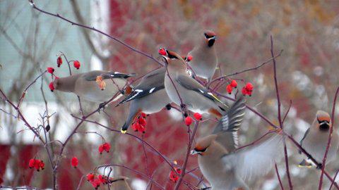
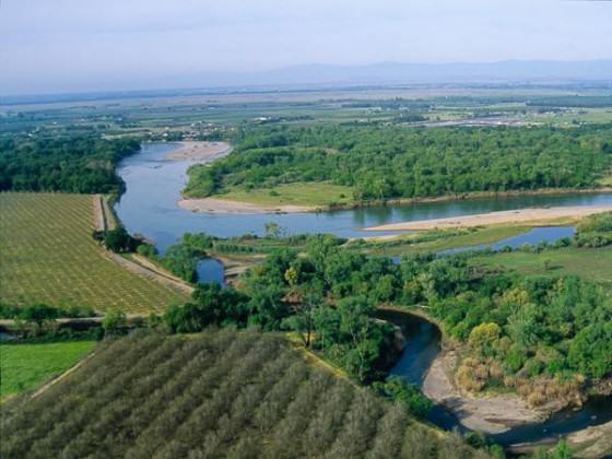
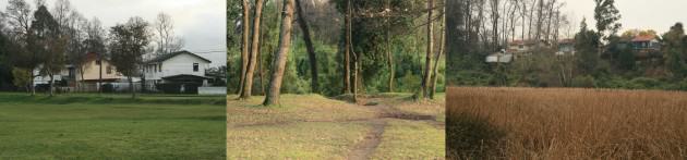
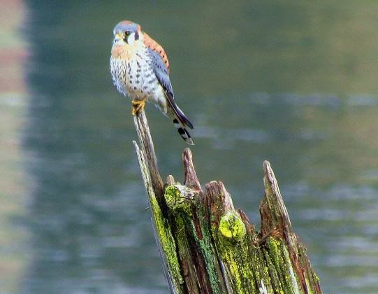
Kim Behrens and I are driving slowly through my Turnagain neighborhood on a snowy mid-December afternoon, when a legion of songbirds prompts us to pull over to the curb, grab binoculars, and scramble out of her truck. In deepening grayness, we stand in open-mouthed amazement among yards that have been ornamented with mountain ash and other fruit trees. In those trees and the sky overhead are dozens of robins and more than a thousand bohemian waxwings.

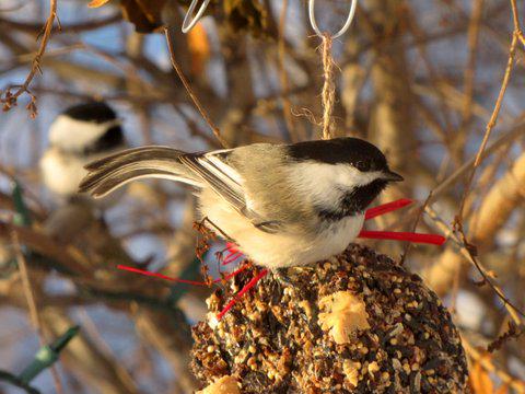
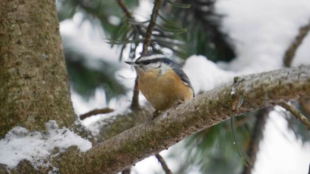
Only minutes before, Kim and I had finished walking a section of Anchorage’s Coastal Trail. We covered 4½ miles in 3½ hours, while shuffling through the snow at an intentionally slow pace. Participants in Anchorage’s annual Christmas Bird Count (CBC), we stopped frequently to look and listen for birds. During the first hour of our walk we counted nearly 20 black-capped chickadees, several magpies and ravens, a few mallards, a red-breasted nuthatch and hairy woodpecker, and hundreds of waxwings, seven species in all. But what began as a light snow became heavy by mid-day and the birds seemed to disappear. By hike’s end we remained stuck on seven species, with nothing unusual to report.

1.A flock of bohemian waxwings feeds on rose hips fruit in a south Anchorage yard. Photo credit: ©Kim Behrens
A flock of bohemian waxwings feeds on rose hips fruit in a south Anchorage yard. Photo credit: ©Kim Behrens
A black-capped chickadee sits on a hanging feeder in an Anchorage yard. The bent tail is from spending the night in a tight-fitting cavity. Photo: ©Kim Behrens

Now, passing through another CBC team’s area, we don’t concern ourselves with counting birds, only enjoying their presence and wondering if we’ll spot a local rarity, a dusky thrush that’s been reported hanging out with the robins, which in recent years have overwintered in Anchorage in steadily growing numbers.

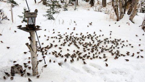
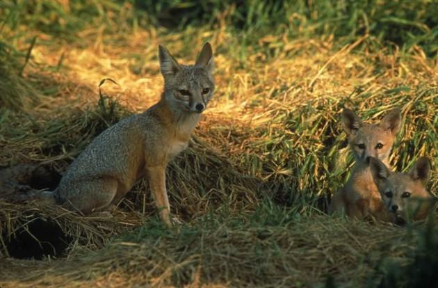
We don’t see the rare thrush, but that’s okay. I’m simply delighted to be in the company of so many robins; we’re surrounded by several dozen of them, the most I’ve ever encountered at one time, by far. Later I’ll learn that one group of CBC participants counted a flock of 90 robins—ninety!—a number that seems remarkable to me. Hunkered down among clusters of mountain ash berries, the robins are spectacle enough. But the waxwings add to our pleasure. Well over a thousand of them swoop and circle through the neighborhood, landing on trees and then lifting off again with a great and startling whoomph.

Eventually more Christmas Bird Counters arrive and put binoculars to eyes, still hoping to see that dusky thrush among the many robins. Residents shoveling their driveways seem as curious about us as the swirling, berry gobbling birds we’re watching and a group leader takes the opportunity to explain why we’re out here, what we’re doing.

Red-breasted nuthatch perched on tree in a mid-town yard, Anchorage. Photo: ©Wayne Hall


A flock of common redpolls crowd together while feeding on seed scattered on boards and snow, south Anchorage yard. Photo: ©Kim Behrens.
A flock of common redpolls feeding on seeds in feeders and snow. Photo:  ©Kim Behrens
A flock of common redpolls feeding on seeds in feeders and snow. Photo: ©Kim Behrens

The evening of Dec. 14, a few dozen birding enthusiasts gather for the local CBC tally, feasting on the chili, corn bread, and desserts that are part of the ritual. The crowd is smaller than usual because of the storm, but there’s plenty of enthusiasm and laughter as the day’s results are reported and stories are shared.

The final count: only thirty species, a low number attributed at least in part to the weather. Most years around 40 species are observed and in 1984 an Anchorage record 52 species were counted. No group saw more than fourteen species and most counters observed ten species or less.

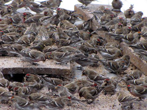
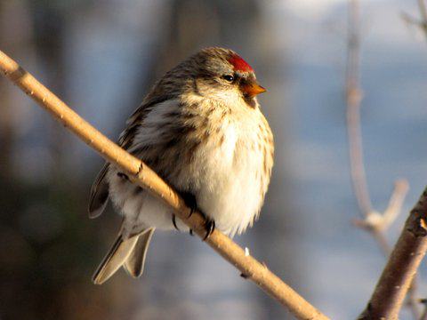
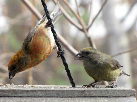
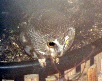
Among the surprises: only one owl (a boreal) was seen or heard and only 64 pine grosbeaks and 72 common redpolls were counted, way below average. The redpoll number was especially surprising; last winter, legions of them invaded Anchorage and the local CBC record is 7,917 birds. But redpolls are known for their great swings in numbers from year to year as flocks of them search the northern landscape for food. On the high side of things, nearly 19,000 waxwings (below the record of 22,245, but certainly impressive) and a record 304 robins were counted.

The final human tally was 51 feeder watchers and only 82 field observers. That too is low, organizers tell me. Again, weather likely kept numbers down in this, Anchorage’s 53rd holiday count.

*     *     *

There are any number of ways that urban residents can become more engaged with their surroundings and wild neighbors, and citizen science—which has been described as “public participation in scientific research”—can be an especially effective way of doing so. Perhaps because birds are so ubiquitous, many of the largest, longest lasting, and most popular citizen science efforts are tied to our winged neighbors. And there’s no better example than the Christmas Bird Count. Organized by the National Audubon Society in coordination with its regional and local chapters, the CBC is reported to be the world’s longest-running citizen science survey. Now 114 years old, in recent years it has attracted tens of thousands of participants, who gather information that is added to an ever-expanding database. That data then helps ornithologists and other scientists to track long-term population trends.

A female common redpoll sits on branch, feathers fluffed in deep cold. Photo: ©Kim Behrens
Though not as common as redpolls in winter, pine siskins like this one are another member of the finch family to inhabit Anchorage in winter. Photo: ©Kim Behrens

As the Audubon Society recounts on its website, the CBC’s origins can be traced to an earlier holiday tradition known as the Christmas “side hunt.” Participants would choose sides and then go hunting for birds; whichever team brought in the biggest pile of feathered (and apparently furred) bodies, won the competition. In 1900, ornithologist Frank Chapman of the fledgling Audubon Society proposed a new holiday ritual: a Christmas Bird Census that would encourage people to count birds during the holiday season, rather than kill them. Chapman and 27 others participated in that initial census, which included 25 count areas spread from Toronto, Ontario to Pacific Grove, California (though most were in the northeast United States). Together they tallied 90 species.

By the 2012-2013 count (the most recent for which complete data is available), the number of count areas had increased to a record 2,369 locales while the number of individual observers reached 71,231 people, also a record. The great majority of those count areas are in the U.S., but hundreds more are spread through Canada, Latin America, the Caribbean, and several Pacific islands. (Anchorage’s first-ever Christmas count occurred in 1941, when a single resident went looking for birds, but then two decades passed before a second count was organized, that time with eighteen participants. It has been staged every year since then but once.)

A pair of red crossbills (the more colorful male on the left) eat seeds at a backyard bird feeder in Anchorage. Photo: ©Kim Behrens
A saw-whet owl that took up residence in an Anchorage yard nest box hunts mice in winter. Photo: ©Kim Behrens

The Audubon Society and other Christmas Bird Count advocates emphasize that data collected by participants over the past 114 years has helped “researchers, conservation biologists, and other interested observers to study the long-term health and status of bird populations across North America [and now other areas]” while providing “a picture of how the continent’s bird populations have changed in time and space over the past hundred years.”

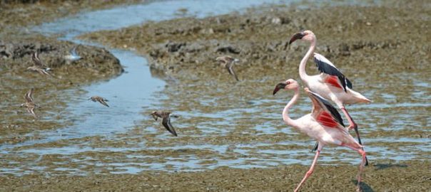
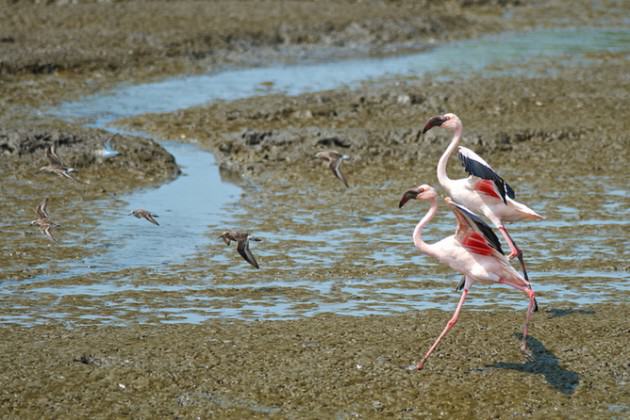
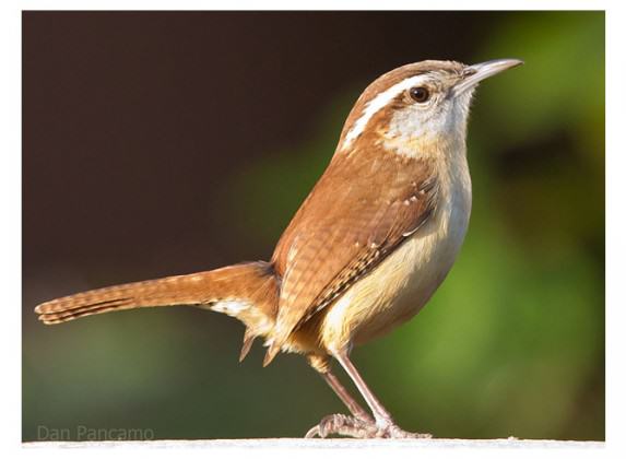
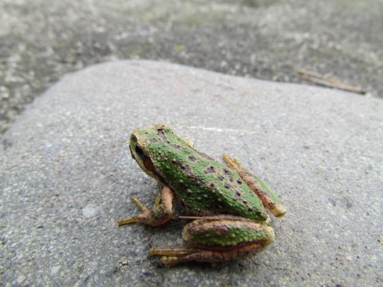
But the CBC and other citizen-science efforts also help to make people more aware of the creatures with which we share the landscape, including and especially urban residents who might normally ignore their presence. Besides the scores of people who participate in Anchorage’s count, for example, thousands more residents are made aware of which birds share our city through the Anchorage Audubon’s website and emails to its members, and also through local media coverage of the event. This is no small thing, especially in winter, when people tend to spend most of their time indoors and give less thought to the animals that share our cities and the habitat that they depend upon. What better way to remind the general public that we human residents of Anchorage share the winter landscape with more than ravens, chickadees, waxwings, and rock doves (the latter better known as pigeons)?

*     *     *

While the Christmas Bird Count is the longest running bird-oriented citizen science project, in recent decades other events and programs have greatly expanded people’s awareness of the wild birds that live among us, even in the most urban of locales. Later this month, tens of thousands of people around the world will participate in the seventeenth annual Great Backyard Bird Count. Organized by the National Audubon Society and the Cornell Lab of Ornithology, the GBBC is a four-day happening that this year begins on Friday Feb. 14 and runs through Monday, Feb. 17.

As explained on the website, this event is intended to engage “bird watchers of all ages in counting birds to create a real-time snapshot of bird populations. Participants are asked to count birds for as little as 15 minutes (or as long as they wish) . . . Anyone can take part in the Great Backyard Bird Count, from beginning bird watchers to experts, and you can now participate from anywhere in the world.”

What makes the GBBC especially effective is this sense of inclusiveness (no special expertise required); the fact that participants don’t have to invest a great deal of time or effort (you can watch bird feeders from the comfort of your home for as little as 15 minutes a day); and the ease of reporting data (at least for those with access to a computer and basic Internet skills). Also appealing in our “instant gratification” times and culture is the fact that participants can check out “real-time maps and charts that show what others are reporting during and after the count.” If that isn’t enough, all participants are entered in a drawing, with the chance of winning prizes that range from bird feeders and books to binoculars. Such a deal!

A Steller’s jay grabs a peanut in a mid-town Anchorage yard. Photo: ©Wayne Hall
A downy woodpecker and red-breasted nuthatch share space at a feeder in a south Anchorage yard. Photo: ©Kim Behrens

There’s also the sense of joining a grand event in which people scattered around the world are increasing our knowledge of birds, while helping researchers “learn more about how birds are doing, and how to protect them and the environment we share.”

In short, the organizing partners explain, “It’s free, fun, and easy.” That’s true no matter where you live, including the innermost parts of cities.

This approach has proved highly successful. In 2013, GBBC participants turned in more than 134,000 checklists (many submitted daily reports for each of the four days) with some 34.5 million individual bird observations, representing 4,004 species, including a record 638 species in the United States. Event organizers received checklists from 111 countries and territories, representing all seven continents. In total, the 2013 GBBC provided “the most detailed four-day snapshot of global bird populations ever undertaken.”

Aside from all the data and whatever help it provides to researchers and managers, the GBBC, like the Christmas Bird Count, also engages significant numbers of people—many of them urban residents—in a citizen science effort that invites people to pay increased attention to their wild neighbors and the landscapes we share with birds.

Complimenting the Christmas Bird Count and Great Backyard Bird Count are two other popular programs that present great opportunities for both urban and rural bird enthusiasts throughout the United States and beyond. One of them is seasonal, the other year-round.

This white-crowned sparrow is an Anchorage winter rarity that stayed the season in a mid-town yard. Photo: ©Wayne Hall

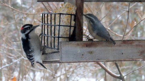
Another “fun and easy” citizen-science program of the Cornell Lab of Ornithology, Project FeederWatch is, like the GBBC, intended for people of “all skill levels.” Now in its 27th season, FeederWatch enlists the help of birding enthusiasts throughout the winter season (from early November into April). Participants keep track of the birds that come into their feeders two days per week and report their observations. Again, it’s an ideal opportunity for people to connect with birds—and the larger world of nature—wherever they live.

The year-round program is ebird. Another cooperative Audubon-Cornell Lab effort, ebird was started in 2002 and its primary goal is to utilize the “vast number of bird observations made each year by recreational and professional bird watchers.”

At various times, I have participated in all of the programs mentioned here while living in Alaska’s urban center. I know firsthand that each citizen science effort, in its own way, provides opportunities for people to pay increased attention to the birds with which we share our home landscapes and to learn more about them.

Because many species adapt to urban environments and they’re often more easily noticed than other forms of wildlife, birds—and programs like those described here—can be ideal portals into a greater appreciation and increased awareness of the wild nature that exists in cities. They’re most valuable during the winter season, especially in northern climes, where darkness and cold make it easy to stay indoors and be less attentive to the wildness and natural wonders that enliven our cities throughout the year.

Bill Sherwonit
Anchorage

On The Nature of Cities

Efficient Roofs for Efficient Buildings: Building Blocks for Energy Efficient Cities in India

Art, Science, Action: Green Cities Re-imagined

I recently relocated to New Delhi after more than a decade — a set of years which entailed rapid economic growth for India. Infrastructure development in cities around the country is booming and it is difficult to travel for too long without meeting the rising towers of concrete and shining glass. Urban population, too, is growing at an unprecedented rate and in these next few decades one of the most massive shifts to urbanization in world history will unfold in India. This urban sprawl creates unique challenges related to land-use planning, ecological structure, pollution, biodiversity, energy demand and cost, heat health stress, and flows of water, nutrient and energy within cities and their surrounding areas. As Indian cities continue to grow in population and area, the magnitude and potential consequences of negative effects on temperature, humidity, cloudiness, precipitation and atmospheric flow patterns are expected to increase.

Ensuring both development and sustainability for India’s cities thus results in a series of interrelated issues concerning clean air, water, waste, food, biodiversity, and energy use — all in the context of rapid urbanization and with the challenges of governance and weak institutional capacity. Cities across the country need to develop policies that strive to balance the competing priorities of substantially expanding while minimizing detrimental environmental and climate change effects.

Amongst the different tradeoffs that Indian cities have to make to be livable and resilient, one significant opportunity stands out: energy efficiency in buildings. Buildings already play a key role in the country’s energy use, currently accounting for more than 30 percent of electricity consumption. Yet, two-thirds of commercial and high-rise buildings that will exist by 2030 are yet to be built. India’s building-occupied area is projected to skyrocket from 8 billion square meters in 2005 to 41 billion in 2030 — a staggering statistic. Analyses of this sector show that India could save $42 billion each year simply by improving energy efficiency in buildings. Further, the need for almost 3,000 MW of generation capacity could be avoided in an already severely electricity-constrained climate. All these factors makes energy efficiency — which is often referred to as an “invisible resource” — the cheapest, fastest and cleanest way to improve the sustainability of cities. The unique crossroads that Indian cities currently find themselves in, where the bulk of building and infrastructure development is yet to occur, means that energy efficiency is a singular opportunity to protect the environment and lock down energy and cost savings.

Recognizing these tremendous benefits of energy efficiency, students at the National Institute of Design in Bangalore created this creative animation, which makes energy efficiency, our collective invisible resource, visible!

Within energy efficiency options, roofs can play an important role in benefiting a building. Roofs can represent up to 32 percent of the horizontal surface of built-up areas and are important determinants of the urban environment. As protected and secure spaces, rooftops have many advantages as a site for urban vegetation — though at present they are largely blighted spaces. Roofs also play an important role in providing passive cooling to the buildings they cover. When constructed correctly, roofs can reduce the urban heat island effect that cities face, which is the result of the densely built urban centers experiencing hotter temperatures than the rural surroundings. Urban heat islands lead to higher energy consumption within cities to keep building inhabitants cool in the summer. Heat islands are also associated with negative health impacts such as increasing mortality rates and hospital asthma admissions.

Within the Indian building sector, commercial and residential buildings in urban areas account for most of the total consumption of electricity. This occurs through a building’s mechanical systems and equipment, including heating, ventilating, and air-conditioning, hot water heating, interior and exterior lighting, electrical power and appliances. Commercial buildings such as new office spaces, IT offices and parks, data centers, hospitals, hotels, retail malls and high rise residential buildings are all becoming more energy-intensive. The rate of increase in commercial electricity consumption is also much more rapid than the annual rate of increase in the floor area of commercial buildings. Unfortunately though, at present most of the modern Indian buildings use more than twice the amount of energy compared with their international counterparts. While many of these new structures can match international standards of appearance with their shining glass surfaces, few of them are designed in a way that pays attention to how these modern buildings actually use and manage their energy.

There are a few champions within the building sector who recognize the many benefits of designing and operating a world-class energy efficient structure — with the positives ranging from:

  • Cost and energy savings from lower energy bills.
  • Increased demand by tenants that recognize the cost savings, energy reduction, and higher employee productivity enabled by energy efficiency.
  • Health benefits from well-designed efficient buildings such as better indoor air quality and a healthier environment leading to higher employee productivity and retention.

Energy savings also lower greenhouse gas emissions, thus effectively addressing climate change and its accompanying hazards. There is a growing awareness in Indian cities about these many benefits, and while slow, the number of green buildings — or sustainable buildings, which are designed to be environmentally responsible and resource efficient throughout a building’s life cycle from siting to design, construction, operation, maintenance, renovation, and deconstruction — is increasing every year. Leadership in Energy and Environmental Design or LEED as it is often referred to, is a rating system for such green buildings. India now has 2,362 LEED registered buildings and 447 LEED rated buildings, with a total of 1.813 billion square feet of green building footprint. The country is said to rank amongst the top five countries in the world for area under green building cover, pointing to the increasing trend towards green and energy efficient spaces over the last ten years.

Some examples of green champions in the building sector from around the National Capital Region of Delhi are:

  • ITC Green Center — With an area of 170,000 sq feet, the Center is the world’s largest zero percent water discharge, noncommercial green building, and compared to similar sized buildings it has a 30 percent smaller carbon footprint. The Center incorporates innovative design, water efficiency, indoor environmental air quality, materials and resource efficiency, a sustainable site, and an ecological commitment to its surroundings. It received a LEED Platinum award in 2004, the highest category of LEED ratings.
  • AECOM (previously Spectral Services) Noida Headquarters — The building has green solutions like an efficient water cooled heating and ventilation system, reuse of treated sewage water for landscaping and the cooling tower, automated lighting systems, a simulated roof skylight designed for optimal day lighting, thermal insulations, solar heaters, and highly reflective roof surfaces. It received a LEED Platinum award in 2007, and was amongst the first buildings not just in India but in the world to receive this rating.
  • Bayer’s Eco-Commercial Building — The eco-commercial building in Greater Noida is Bayer’s first emissions-neutral office building in Asia. It entails various energy conservation measures such as thermal insulation for roofs, lighting controls, efficient central chillers and efficient windows. The roof is fitted with photo-voltaic solar cells. Bayer eco-commercial building received a LEED Platinum award in 2012 and at the time achieved the world’s highest LEED score to date.

Other rating systems that India uses are the Green Rating for Integrated Habitat Assessment or GRIHA and the Bureau of Energy Efficiency’s Buildings Star Rating Program. While rating systems are important in motivating the higher-end of real estate developers, baseline energy efficiency can be established in buildings with the use of energy codes and policies. India has a voluntary Energy Conservation Building Code, which prescribes a minimum standard for energy use in new buildings and major retrofits. The code applies to buildings with a connected load of 100 kW or 120 kVA, which is approximately equivalent to a five stories or higher commercial or high-rise residential building. While each of these initiatives is a step in the right direction, the progress to date remains a small fraction of the overall growth and potential in the building market.

I’d like to focus now on a particular aspect of building energy efficiency that can have significant relevance for urban energy savings and biodiversity: the collective benefits of rooftops. A roof’s reflectivity is a key determinant of the surface temperature that the roof reaches and of how much heat gets passed through to the living space in the building interior. For the same amount of sunlight hitting a roof surface, a black roof can reach a high temperature of 80 degrees C (170 degrees F), and reflects only 5 percent of the incoming sunlight. A white roof, on the other hand, can reflect 80 percent of the incoming sunlight and reaches a much lower temperature of 44 degrees C (111 degrees F). The temperature of the roof can have dramatic influence over the interior living conditions of a building, particularly of the topmost floor. Modifying roof properties to make “cool roofs” — such as increasing reflectivity — can lower roof surface temperatures and thus represents a hugely beneficial opportunity for the mitigation of heat islands in cities and consequential negative health and energy impacts. Delhi’s governing bodies are in the process of promoting cool roofs, starting with installing such cool roofs on Delhi government buildings.

Another option for increasing the passive cooling techniques of roofs is the implementation of green roofs. Having plants, shrubs or grass correctly planted on roof surfaces provides thermal insulation to the building interior, increases the roof’s reflectivity, and increases cooling of the roof surface because of the evaporation of water from the vegetation’s soil (known as “evaporative cooling”). Green roofs are characterized into two general types, intensive and extensive, differentiated mainly by cost, depth of growing medium and choice of plants. Benefits of green roofs cover a large spectrum, including: preventing storm water runoff, creating an urban wildlife habitat, improved health from visual contact with vegetation, increased employee satisfaction, reduced stress, increased community space and overall improved livability of cities. These are in addition to energy and cost savings and reduced greenhouse gas emissions. In spite of these many benefits though, green roofs are yet to find widespread implementation in Indian cities, and a few successful pilot projects may help jumpstart this trend.

An alternative traditional solution for passive cooling which is used at times, and which utilizes the same principal of evaporative cooling, is to place clay pots filled with water on the building roof so that the day’s heat is used to evaporate this water instead of heating roofs and building interiors.

Photo: Radhika Khosla

As Indian cities move into an unprecedented phase of growth and increasing accompanying stresses, cities will require livability and resilience to be built into their development plans. This will require alternative sources and spare capacity, contingency plans and the ability to recognize and react to new challenges and opportunities with innovative solutions. Identifying easy, quick and cheap solutions is a key part of this process, and given the staggering growth of India’s building occupied area — which is projected to skyrocket from 8 billion square meters in 2005 to 41 billion in 2030 — implies that incorporating building energy efficiency can help create new paradigms of urban development for cities across the country.

Radhika Khosla 
New Delhi


On The Nature of Cities

Biodiversity Can Flourish on an Urban Planet

Art, Science, Action: Green Cities Re-imagined

Mention the word biodiversity to a city dweller and images of remote natural beauty will probably come to mind — not an empty car park around the corner. Wildlife, we think, should be found in wild places, or confined to sanctuaries and national parks. But research shows that cities can in fact support biodiversity and this can have major implications for conservation efforts.

A pair of lesser flamingos in Mumbai’s busy port area.  Photo: Madhusudan Katti
A pair of lesser flamingos in Mumbai’s busy port area. Photo: Madhusudan Katti

On a crowded planet, protecting species in their natural habitat is proving increasingly difficult. Humans continue to expand their networks of cities, towns and farms worldwide. By 2030, cities are expected to occupy three times as much land as they did in 2010. Remaining natural habitats are now often a fragment caught in this global web of cities connected by transportation networks. With the number of species going extinct on the rise, it is necessary to consider the potential of urban environments to serve as refuges for the survivors.

In 2010 the Convention on Biological Diversity commissioned a new global assessment of the state of biodiversity in urban areas. Their findings, published in the book Cities and Biodiversity Outlook, were not entirely bleak. It turns out that cities support biodiversity and provide opportunities for innovative approaches to conservation.

Urban habitats obviously differ in many ways from rural ones. The number of species that occur in any given city depends on the extent to which it supports native species’ habitats and on the introduction of non-native species. A recent global analysis of urban plant and bird diversity found that cities have lost an average of one-third of the native species found in their surrounding region.

While this level is worrying, it is worth noting that two-thirds of the native plant and bird species continue to exist in cities that were never designed with biodiversity protection in mind. In fact at least 20% of the world’s known bird species now occur in urban areas, as do at least 5% of the known plant species. More conscious green landscape designs can only help support more of the native species diversity.

While urbanisation displaces many species, we also know that others have adapted to not only survive, but thrive in cities. House sparrows, rock pigeons, starlings, brown rats and feral house cats are just some examples of species that are ubiquitous in many cities worldwide. More surprisingly, many rarer species are adapting to suburban environments that have taken over their native habitats, including the San Joaquin Kit Fox of central California.

San Joaquin kit foxes find survival easier in suburbia than their natural habitat. Photo: Peterson B. Moose

For many native species, urban habitats may actually be more attractive as refuges. They provide easier and more predictable access to water and food resources, warmer temperatures in the winter and often fewer predators. Continued breeding can drive the long-term evolution of urban species as they adapt to their new environment.

Species such as the house sparrow have evolved to be so strongly dependent on human habitation that their numbers have rapidly declined over recent decades following changes in the urban landscape. Warmer nights and feeding by humans have even changed the migration pathways and geographic ranges of some migratory species. For example, a population of European Blackcap Warblers now winters in suburban southern England instead of Africa.

Noise pollution is another factor influencing urban ecology and affecting the many animals that communicate using sound, such as birds, frogs and some insects. Birds that have adapted to the urban soundscape show distinct dialects with songs that are simpler, louder or higher pitched to cut through the background noise.

San Francisco’s resident White-Crowned Sparrows have changed their tune over the past 30 years as the city has grown noisier, losing some distinct notes of their songs. This may have evolutionary consequences because dialect formation is often the first step towards speciation. Other studies have found genetic differences between urban and non-urban populations of some species, indicating fairly rapid evolutionary changes.

New wildlife communities are coming together in cities, often with accidental manipulation and active management by humans. These communities can play an important role in both the urban ecosystems and for surrounding habitats. Gardens, for example, can support important reservoir populations of bees and other pollinators that could be valuable for many plants but find it difficult to survive under modern intensive agriculture.

So the overall picture is not bleak. Cities can provides new habitats and niches that may be quite different from those in natural ecosystems, but still can support a variety of species. Species that evolve under such urban conditions may well represent what the future holds for much of Earth’s biodiversity.

Madhusudan Katti
Fresno, California

This article was originally published at The Conversation
Read the original article

What Is the Point of Zoos?

Art, Science, Action: Green Cities Re-imagined

What’s a zoo to you?

“Zoo” was one of the first words I learned to say, and the local zoo was my favorite place to visit as a child. I can’t be sure that it was that experience which led me to decide, at an early age, to pursue a career in conservation but I suspect that my mesmerizing encounters with captive wildlife, through barely-noticed bars or wire, had a lot to do with it. I have a pretty poor long-term memory, but those feelings remain vivid. And yet that zoo, which recently closed down due to financial woes, was a far cry from the modern concept of a zoo.

Children captivated by an aquarium exhibit. Photo: Andre Mader

My own experiences, and my observations of others’, demonstrate that zoos can leave a strong impression — especially on children. It is no accident that zoos are typically located in cities, where they are most easily accessed by the world’s majority-urban population. Zoos attract an estimated 150 million people per year in the USA alone. These days kids have plenty of other things competing for their attention (and their pocket money), but zoos do continue to attract, adding modern and technological innovations to enhance that competitiveness. These innovations are added to the undeniable uniqueness of the live wild animal experience.

Zoos typically celebrate exotic nature — in fact “the more exotic, the better” seems still to be the general view. Efforts are made to give the impression that exhibits are worlds of their own, transporting audiences’ imaginations away from the city surrounding them. Nevertheless, the fact is that zoos allow people to experience nature without leaving the city. They may or may not play a role in affecting perceptions of urban nature in particular, but I can attest from personal experience that they have the potential to do so after visits to the local snake park piqued my interest in local reptile species (the only ones to which I had access outside the snake park).

Crowds gather at hourly intervals in Cologne Zoo to watch an eagle alight on its handler's arm as he stands among them. Photo: Andre Mader
Crowds gather at hourly intervals in Cologne Zoo to watch an eagle alight on its handler’s arm as he stands among them. Photo: Andre Mader

To me, the two most important functions served by nature in the city (whether in the form of adaptive “free-range” urban species or captive zoo animals) are to increase awareness about nature so that its plight might be supported; and to enhance the lives of city dwellers. I would argue that zoos fulfill both roles remarkably well, and that the lower frequency with which they are visited, relative to city parks for example, is compensated for by the intensity of those experiences.

Having said that, I am also a great advocate of zoos that focus on native species and their ecosystems, and I hope to one day see, or hear about, an urban exhibit that truly links zoos with the cities that surround them. Neither would such an innovation need to be limited to rats and pigeons, as readers of this forum are well aware. While we wait for (or act upon) that possibility, it is good to note that zoos have come a long way, over a long span of time, and continue to evolve.

London Zoo Monkey House in 1835

A brief history of zoos

The oldest known approximation of a zoo was uncovered as recently as 2009, but dates back to 3500 BC Egypt. This, apparently private, menagerie included hippos, elephants and baboons among 112 animals in total. The first evidence of a more typical zoo came much later, in the 1200s, when Henry III of England displayed animals, given to him as gifts, to the public. This tradition continued over the centuries and, during the 18th century, the price of admission to see the king’s animals could be substituted by supplying animals to feed to them. The explosive growth of London in the 1800s led to an increased appetite for public entertainment. There was a concurrent increase in public interest in natural history as explorers brought back a seemingly inexhaustible supply of exotic creatures from far-flung corners of the colonial world, Together, these factors led to  the founding of the first modern zoos. The Zoological Society of London was founded in 1826 and as an extension of it, the London Zoo — the world’s first scientific zoo — opened to the public in 1847. With a series of ground-breaking attractions such as the first live hippopotamus to be seen in Europe and the first elephant (the illustrious Jumbo) to be seen live in England, it became extremely popular with London’s burgeoning population. In 1907, another landmark was reached in the evolution of zoos when Carl Hagenbeck founded the Tierpark Hagenbeck in Hamburg. His zoo was the first without bars, instead using moats to keep animals from escaping and thereby creating a more natural feel for visitors. This also helped to approximate the natural habitat of the animals exhibited.

The history of zoos was, however, not one of unidirectional progress. Even with these advances, conditions for animals were notoriously miserable, and little attention was paid to their welfare. Nor were animals the only ones affected by these methods. As recently as 1906 the Bronx Zoo in New York (the current motto of which is “connecting people to wild nature”) included in their primate exhibit a young Congolese pygmy tribesman named Ota Benga, supposedly to illustrate the differences between people of European and non-European origin and illustrate the theory of evolution. It triggered protests — not from human rights activists but from the city’s clergymen, whose aim was to debunk the theory rather than the inhumanity of the exhibit. Various peoples of France’s empire were also displayed during the 1931 Paris Colonial Exposition, and as late as 1958 a “Congolese village” display featured at Expo ’58 in Brussels.

Bactrian camels at the Cologne Zoo. A decreasing population of less than 1000 persist in the wild. Photo: Andre Mader

A more enlightened era

With a growing public awareness of environmental issues in the 1970s, certain pioneers began to consider conservation as the central role of zoos. Among these were Gerald Durrell, who established the Jersey Zoo in the Channel Islands. Durrell was the closest I had to a childhood hero, and his reputation and work were magnified through a series of well-written books that are, today, still popular around the world. Durrell and a gradually increasing cohort of like-minded contemporaries began changing perceptions of the role of zoos. Along the major advances included the Association of Zoos and Aquariums (AZA) making conservation its stated highest priority. In parallel and likely related to this shift, many zoos also stopped having animals perform tricks for visitors.

Naturalized exhibits and modern materials enable audiences to get much closer to wild animals at modern zoos. Photo: Andre Mader

Leading zoos are now also employing ever-more innovative, high-tech exhibits. One of the greatest challenges in a zoo I took part in establishing in the United Arab Emirates was the design and construction of a tidal mangrove tank, but the result is visually arresting. At a much larger scale, in May 2014 Indianapolis Zoo is due to launch a multimillion-dollar project enabling orangutans to travel on an overhead cable system above the zoo completely unconstrained by cages or walls. Zoos around the world have taken to erecting non-obtrusive video cameras in cages so that animal fans can keep track of their favorite species between visits.

Sadly, however, even nowadays many zoos remain woefully indifferent towards either animal welfare or conservation. This, as well as some proportion of sub-optimal exhibits in even the most advanced zoos, and memories of zoos of decades past, keeps the anti-zoo lobby strong. Neither does it help that the stated primary aim of many zoos — conservation for the sake of reintroduction, is often difficult to prove or to justify in the case of most of the species in their care. While it is true that zoos are achieving increasing success in terms of rescuing species from the brink of destruction, the value in preserving and breeding them is limited if the habitat they rely upon continues to diminish, or if other threats, like poaching, persist.

Indeed, that may not be where the greatest potential of zoos lies.

Zoos and perceptions of nature

Zoos have another justification for their existence, which was introduced at in the beginning of this piece: a unique opportunity to communicate an appreciation of nature to their visitors, in disproportionately powerful and impactful ways. Recent studies in the field of conservation psychology indicate that a physical separation from nature, as epitomized by cities, leads to a psychological separation from nature. This means people who are less exposed to nature care less about it and are less likely, for example, to vote green. Nature in cities is critical here, in all its forms, including zoos. A three-year study involving 5,500 visitors to twelve AZA-accredited zoos and aquariums found that visits prompt individuals to reconsider their role in conservation action, and to see themselves as part of the solution; and that they believe they experience a stronger connection to nature as a result of their visit. It also has implications for human health: numerous studies in eco-psychology (as distinguished from conservation psychology) have shown that we need a dose of nature for optimal health. Zoos provide some of this medicine by bringing wild nature to the city.

A final word on zoos relates to our role. Just as zoos can affect the public’s views, so can the public affect the views of zoos. A more informed public will support the good work that zoos are doing and discourage the bad. It’s therefore easy to see the importance of a zoo being in sync with the conservation goals of its host city. The more zoos can involve their local communities (for example by providing discounts to locals or school groups; or partnering with local government, NGOPs, botanical gardens and others in city-wide awareness-raising initiatives), the greater their potential effect on those communities. Pay your local zoo a visit if you haven’t done so for a while. See whether or how it’s changed; note what innovative approaches are taken to educating and entertaining the public; watch the way people interact with these surroundings. I’d be interested to hear any of your thoughts before or after that visit.

Andre Mader
Montreal

On The Nature of Cities


Involving Children in the Design of Park Renovations to Create Green Places for Play with Urban Nature

Art, Science, Action: Green Cities Re-imagined

The “Megurizaka pond renovation” project started in 2008 by creating a place for children to play and help restore nature to a small part of Kitakyushu City in southern Japan. The aim was to create an area for children’s play and ecological education that could also form a part of an ecological network in the urban zone.

A generation ago, children had access to wild lands and used them for exploring, challenging and exercising the skills needed to master a complex landscape and unforeseen situations. “Children’s play” is an important experience in learning about the structure of nature, but “environmental education” has been afforded much greater importance in primary and secondary school education in Japan since 2002. Thus, preserving open spaces as wildlife habitat where children can play would be a very important addition in urban areas.

The project site before the renovation. Egeria densa, an exotic species, dominated the water. Photo: Keitaro Ito
The project site after the renovation. Photo: Keitaro Ito

Process Planning

Although we knew the general direction in which we wanted the project to proceed, it was difficult to predict what kind of flora and fauna would establish there, so we needed to choose a flexible planning method for the project. The architect Arata Isozaki describes three different types of planning.

1) “Closed planning”, which takes every aspect of the planning process into consideration

2) “Open planning”, which focuses on development for the future

3) “Process planning”, which focuses on the planning process itself and not solely the end form.

We felt that “process planning” was the best, given that the space would naturally evolve over time and that its form was likely to change according to the needs of those who use it. We also referred to 80 year old map to know the history of this district. Based on this map it was clear that the landform had been dramatically changed; it was interesting that we had water flow from near forest to this pond.

The 80 year old map we referred to in this district. There used be many ponds, however now there are just two. They were described as being covered with Lotus flowers.

Landscape planning for multiple functions 

According to this method, the space was divided into a number of overlapping layers: vegetation, water, playground and ecological learning. However, unlike “zoning”, Multiple Function Landscape Planning (MFLP; Ito et al., 2010) does not separate a space into distinct functional areas. The overlapping of layers creates multi-functional areas in which, for example, children who are playing by the water can also learn about ecology at the same time. Thus, with the creation of multi-functional play areas, children are able to engage in various activities as different layers are added on top of each other. In addition, we expected they would learn something new about the ecology when they were playing there at the same time.

Multi Functional Landscape Planning. Credit: Ito et al. 2003, 2010
Plan for the water renovation. Credit: Keitaro ITO, 2008

Children and teachers participating in planning of their own ecological play spaces

Children at the school, their teachers and a number of university students participated in the planning and construction phases of the project and in making improvements to the park. At first, the children and the university students were surveyed about the kind of insects and plant life they hoped to find in the park. During workshops they were asked to make final presentations about their image of the park based on everything that had been talked about in the previous workshops. The children made suggestions for the water environment, in particular regarding fish, small aquatic insects and the depth of the water. They came out in favour of planting fruiting trees to attract birds and evergreen and deciduous trees to attract small animals and insects. Following this, the final drawing and model was completed by Keitaro ITO’s Laboratory (images above and below).

Planting trees was the students’ idea, and the park subsequently succeeded in attracting birds on numerous occasions. As a result, it was suggested that the park could become one of a number of habitats for bird and insects in this urban area.

In short, this city park not only provides the children with a place to play in a variety of ways but has also become a habitat for a number of living creatures such as birds, insects and fish.

1/100 model for the renovation. Credit: Keitaro ITO Lab. , 2008
Children participating in the restoration, using the wood that used be this park. Photo: Keitaro Ito
Children playing in the project site. Photo: Keitaro Ito

Future issues

The children have learned about the existence of various ecosystems by playing in the park and through their participation in the planning workshops. The teachers and a number of local residents have also been active in this process, and their interest in the park remains strong because they actively participated in the development of an accessible environment and have been able to propose ideas for its future management.

 Nevertheless, the following issues were encountered during the planning of the park. First, it needs a great deal of time to plan and manage the project.  Second, the cooperative framework in which the park is managed changes every year because the teachers are transferred to other schools every 3 to 5 years. This creates some difficulties in attempting to maintain continuity in the planning process over time.  

The city park is not so big but it has been gradually changing into an urban biotope over the past five years and the ecosystem contained in it has become more complex every year. It is important that this type of city park can contribute to the ecological network in the city. For example, a lack of outdoor space to play in, fear of violence in public spaces, the longer working hours of parents and the artificial nature of most playgrounds have helped create the present-day situation in which young children have gradually lost contact with nature.

So, I think that the present-day planners and landscape designers consider “landscape” as an “omniscape” (e.g., Arakawa,1999, Fjortoft & Ito, 2010). It is much more important to think of landscape planning as a learnscape, embracing not only the joy of seeing, but also stimulating the five senses as a whole.

Keitaro Ito
Kyushu

On The Nature of Cities 

References

Arakawa, S. Fujii, H. (1999) Seimei‐no‐kenchiku (Life architecture), Suiseisha, Tokyo.

Ito, K., Fjortoft, I., Manabe, T., Masuda, K., Kamada, M. and Fujiwara, K. (2010). Landscape design and children’s participation in a Japanese primary school – Planning process of school biotope for 5 years. Urban Biodiversity and Design. Conservation Science and Practice Series. 441-453, Blackwell Academic Publishing. Oxford.

Fjørtoft I. and Ito K. (2010) How green environments afford play habitats and promote healthy child development. A mutual approach from two different cultures: Norway and Japan. Science without Borders. pp. 46-61, Transactions of the International Academy of Science H&E.


A Matter of Scale: Connecting Human Design Decisions with Decisions Made by Wildlife

Art, Science, Action: Green Cities Re-imagined

Ok, if you can look past my anthropomorphic statement that wildlife make decisions, the topic I would like to address deals with the adoption and use of ecological principles by the design community. Patch size, landscape connectivity, edge effects, corridor ecology, landscape ecology, and metapopulation theory are just a few terms and ideas put forward by researchers to address the biological integrity of wildlife populations. Often, planners, landscape architects, engineers, architects and other built environment professionals adopt these ecological principles into their designs of regions, cities, and individual developments.

But do these designs function as originally intended?

Red-shouldered Hawk in San Francisco. Photo: Walter Kitundu
Red-tailed Hawk in San Francisco. Photo: Walter Kitundu

Habitat patches and design

A common application of ecological principles into urban/rural design is the establishment of natural to semi-natural patches (or remnants) of areas that would serve as habitat for wildlife. This design application begs the question, “For which wildlife species?” In many (of my) dealings with design firms and city/county departments, this rarely is addressed. For the most part, people look at a land use/cover map and try to conserve as many of patches as possible, without much thought about wildlife species in the area or those migrating through.

While conserving any remnant patches is a laudable goal, in many instances the amount of patches, in terms of actual area, that a developer will conserve is limited. Thus, it is critical to select the patches that “give the most bang for the buck.” An ecologist would select those patches that benefit local species or improve species richness, depending on the original goals and what the site can offer. Selecting the “best” patches can benefit a variety of species, but it depends on the scale of the design and those species that respond to the geometry of the landscape at that scale.

New York City Central Park. Photo: Sergey Semenov
New York City’s Central Park – a city habitat patch that is used by wildlife. Photo: Sergey Semenov

Animals locate themselves based (for the most part) on the spatial geometry of landscape structure across a region. However, smaller animals have a very different view of the landscape than larger animals. Imagine a Carolina Wren (Thryothorus ludovicianus) and a Red-tailed Hawk (Buteo jamaicensis) flying over a neighborhood (the images that follow). Both birds are responding to landscape structure within cities that attracts them to one area versus another. The smaller Carolina Wren and the larger Red-tailed Hawk respond to landscape structure across a range of scales, but the range of scales are different between the two species.

Carolina Wren. Photo: Dan Pancamo (Wikipedia)
Red-tailed Hawk. Photo: Dan Sudia

Scale” essentially means the size of an area (e.g., 1 hectare, 5 hectare, 20 hectare, etc.). When a bird “responds to” an area, it is attracted to that area based on spatial objects within it. “Spatial objects” are the actual structures (such as trees, bushes, fields) within a given area that an animal uses to fulfill daily food, cover, and water needs. The scales at which wildlife respond to spatial objects are an important part of habitat selection.

Let’s take a theoretical representation of a Carolina Wren and a Red-tailed Hawk responding to spatial objects as they search for habitat (the drawing below)). The wren searches a tract of land to establish a home range. At the next scale, the wren searches its home range for suitable habitat patches for nesting or foraging for food. Then, within these habitat patches, the wren locates food patches where food items (e.g., insects) are abundant. This is the smallest scale in which the wren searches for food. The hawk has a similar set of decisions, but it selects much larger areas and objects at each comparable scale. Notice that the only overlap in scales is at the food patch level for the hawk and at the tract level for the wren.

Scale-dependent decisions of a Red-tailed hawk and a Carolina Wren. Illustration by Rebekah McClean.

Different wildlife species respond to different objects within a landscape. The type of object a species prefers is dependent on its natural history: what it eats, what it needs for nesting, etc. For example, one wildlife species could prefer tree patches. Another species prefers flowering plants. Others prefer woods along streams (riparian habitat). Some prefer natural, open fields. Some even prefer the actual homes (buildings) and others prefer lawns. In addition, the size of these spatial objects is important too. Different species may respond to different sizes of a particular object in the landscape. Let’s say two species like open areas (e.g., lawn). One species, such as a robin, may be attracted to a front yard. Another species, say a hawk, may prefer large expanses of lawn (e.g., golf courses). They both respond to lawn. However, the area of lawn is much bigger on a golf course than a front yard.

In addition, during different periods of an animal’s life, it may have different requirements for food, water, cover, and space. For example, birds may have vastly different requirements when breeding than when they are migrating or wintering in an area. Some bird species only nest in large expanses of wooded areas to keep their nests hidden from predators while primarily catching insects to feed their young. However, outside the breeding season, these same birds can be found in small patches of forest feeding on a variety of food items including fruits and seeds (e.g., Ovenbird, Seiurus aurocapillus).

Ovenbird. Photo: AJ Hand, Connecticut Ornithological Association

After the breeding season, many young animals disperse from their natal site looking for new areas that provide food and shelter. For animals that are dispersing, many urban sites that may not be appropriate for breeding could serve as ‘dispersal sites’ where animals can feed and rest when searching for new habitat. These dispersal sites can serve as corridors that help animals move from one habitat to the next. In addition, urban sites can serve as “stopover sites” for birds that are looking for food and shelter along their migration route. Radars around cities have detected massive amounts of birds flying at night in and around cities. Urban areas can also serve as wintering sites for animals that normally breed outside of urban areas.

In summary, a particular patch can serve as habitat for animals during different times of the year. A patch of woods, for example, may be a breeding area for some animals while at other times of the year it may serve as a stopover site or wintering site. In many cases, the property may serve primarily as a ‘connector’ between natural areas — an important role to permit the movement of animals.

Habitat edges and design

In design studios and planning conversations that I have had, I frequently make the argument that larger, circular patches are better than irregular-shaped patches. This is because “specialist” species are more vulnerable to edge effects than “generalist” species. Generalists are species that will eat a variety of items and live in a variety of habitats. Generalists can adapt to new food sources and changing landscapes.

Think about house sparrows (Passer domesticus) and European starlings (Sturnus vulgaris). These exotic birds are found throughout many countries and are outside their natural range in Europe, but they are doing quite well in urban and agricultural areas. Specialists, on the other hand, are much more specialized or particular in their food and shelter requirements. They will sometimes only eat a few types of food and live in only one type of habitat. They do not adapt well to changes in their preferred habitat and will go extinct locally (i.e. extirpated) when their habitat changes. Most species that are listed on the U.S. endangered and threatened species list are examples of specialists.

Riparian edge next to agriculture. Photo: Geoffrey Fricker, Univ. of California Agriculture

Specialists are most vulnerable to edges. Specialists living in habitat edges tend to encounter higher levels of predation, damage stemming from human disturbances, and increased competition from other species; thus they tend to avoid edges. Specialists typically do not do well in fragmented areas consisting of relatively small, remnant patches. In fragmented areas, small natural remnants are not buffered enough against human disturbances and are more exposed to traffic, noise, and artificial lights. How far the edge effects extend into a patch is variable and depends on the species in question, the type of disturbance, and the types of vegetation found along an edge. It can extend hundreds of meters into a patch even for small birds; for example, Varied Thrushes (Ixoreusn aeviu) had lower relative densities up to 140 meters into a patch than in areas further than 140 meters from the edge.

I have heard from many landscape architects that they think edges are good because they increase biodiversity. Well, yes and no. It depends on the situation. Yes, in most instances having lots of edges tend to increase the diversity of species, but the increase is due to the increase in generalists and exotic species that are more adapted to edges and urban conditions. Thus, in reality, having lots of edges favors generalists that are doing well anyway in a region and conservationists are more concerned about impact of urban areas on specialists.

Wildlife corridors and design

Another common application of ecological principles in urban/rural design is the establishment of corridors for wildlife. Corridors are placed to connect patches within a development or outside of the development. The idea is to promote movement of wildlife species across the landscape. Again, this application begs the question, “For which wildlife species?” However, rarely is this addressed during discussions.

Florida Wildlife Corridor Initiative

As discussed above, scale matters, even for connectivity. How wide is wide enough? A corridor needed for a bear is much wider than what is needed for a mouse. For wildlife, corridors can serve two purposes. First, connections allow animals to reach diverse habitats within their home ranges; and second, at a broader scale, connections permit occasional movements between somewhat isolated populations of wildlife (i.e., metapopulation theory).

But are we talking about movement of panthers or insects? For those that are edge-avoiders (e.g., many specialists species), a corridor may not act as a conduit if it is narrow and mostly edge. In some countries, linear corridors are not really needed, but “stepping stones” of vegetative patches could act as corridors. For example, New Zealand is devoid  of native, terrestrial mammals (save a few endangered bats); ecologists talk more in terms of “stepping stones” of restored and remnant native vegetation to help improve the spread of native, animals across a landscape.

Any natural connection, no matter how small can benefit certain species (think insects, toads, and salamanders). But before a design is made (and space for development given up), a thorough understanding of local, regional, and migrating species (and their habitat/dispersal needs) should be acknowledged and addressed by the designers.

What does all this mean when making planning/design decisions?

From the discussion above, one might conclude that only large, connected patches of vegetation are worth saving in a design. However, if you reduce the scale of your thinking, any natural patch can benefit biodiversity and animal species, no matter how small and isolated. While such patches may have limited appeal for some of the larger animals and the specialists, they may still serve as habitat for smaller species such as lizards, frogs, and insects. They could also serve as temporary refuge for migrating animals (e.g., stopover sites for migrating birds). Not to mention plant diversity as well and the multitude of soil biota that occur in small, conserved remnants!

But if one is considering large patches, and large corridors, for relatively larger animals, a discussion must ensue about which species these patches would likely benefit. Policies that impact land use maps (generally at broader scales) and policies that address land development regulations (i.e., policies that operate on landscape structure at smaller scales) should be considered in the context how they affect large to small species.

Master site plan for The Woodlands at Davidson, North Carolina, which contains a wildlife corridor down the middle. Courtesy of the Lawrence Group.

Overall, such discussions will help make transparent the wildlife benefits of a development design at both small and large scales. For example, that Red-tailed hawk appearing in a backyard is contingent on individual lot designs (e.g., leaving those large snags or trees for nesting), available habitat in a neighborhood (e.g., land development regulations that addressed conserving remnants and using native plants in landscaping), and city land use maps (i.e., plans that address the juxtaposition of open space and built areas).

There is a direct connection between the design decisions made at different scales and the distribution of wildlife species within a region!

Currently, there is a Roundtable discussion this month – “Should programs in architecture, urban design, and landscape architecture require a certain minimum level of learning about the fundamentals of ecology? Why?”  My two cents should be apparent, a resounding YES!; programs in architecture, urban design, and landscape architecture should require a minimum of learning about the fundamentals of ecology. Why? Because I think (not to step on anybody’s toes, there are many good exceptions) these fields tend to focus on the design towards aesthetics and the use of ecological principles in a project design tend to be tepid. In general, long-term functionality of conserved patches and corridors are not addressed in most individual development and city designs.

As I have mentioned in my other blogs, design is important BUT IT IS ONLY THE FIRST STEP. What goes on around conserved patches and corridors, such as nearby land uses, can have heavy impacts and prevent wildlife from utilizing these habitats. Think of invasive exotic plants spreading into remnants and corridors, fertilizers running off properties and entering wetlands, and nearby residents illegally using these natural areas for all-terrain-vehicles. The management of these patches and corridors are just as critical, even more so when situated near urban dwellings. Funds are needed to do prescribed burns, trash pick-up, invasive exotic control, and other management practices. Urban patches can attract a variety of wildlife, if they are managed appropriately.

Good design is not enough, it must be combined with good management.

Hooded Oriole. Photo: Walter Kitundu

Further, residents must be engaged as they are (by default) the long-term stewards of the conserved areas. Part of a design project could include education and engagement programs that include the installation of educational kiosks that help inform residents about the importance of managing their own homes, yards, and neighborhoods in an ecologically sensitive manner.

Thus projects that could contain natural patches and corridors for wildlife, design professionals should be trained about long-term management options for their designs. Nearby built infrastructure should be designed with the idea of limiting impacts on natural areas — for example, limiting the amount of lawn and incorporating more native plants into a landscape would minimize impacts. The context and site conditions for each development will dictate the optimal design.

Perhaps, for instance, it may behoove one to fill in wetlands in order to conserve larger patches. WHAT? I can hear the protests now. However, filling in wetlands may work to avoid this scenario: if all, small wetlands were conserved, then a more fragmented landscape containing wetlands and conserved upland areas would be surrounded by built landscapes and prone to daily impact by nearby homes and streets. Designating larger conserved areas, separated as much as possible from built areas, would make management of the conserved areas easier, and such a design helps buffer against impacts stemming from built areas, in part by reducing the edge effects discussed above.

Each site is different and opportunities exist at different scales to benefit local, regional, and even global species. Collaborations between ecologists and built environment professionals can help to create “doable” wildlife conservation goals for a site, whether it is focused on specific species or general biodiversity conservation. Such collaborations will result in optimal designs for wildlife conservation However, we must put management on the same pedestal as design. Successful projects will only come about when “optimal” ecological design is combined with “best” ecological management practices.

Mark Hostetler 
Gainesville

On The Nature of Cities


Can Devastated Landscapes Inspire Planning and Adaptation?

Art, Science, Action: Green Cities Re-imagined

Changes that cause major disruptions in human settlements, such as those triggered by earthquakes, tsunamis and volcanic eruptions, can give rise to new landscapes that reveal a natural cycle, which is part of the territory where cities grow and develop. These landscapes emerge particularly in cities exposed to recurrent natural disturbances, such as earthquakes, where the natural and human environments are modified. Newer landscapes evolve from geomorphologic, ecological and social changes, and are, at first, usually rejected by the population due to the extent of the disaster. However, over time these new landscapes can be appreciated as they create attractive environments with a strong local identity. This is the case of the city of Valdivia, Chile, where landscapes created after disasters have been safeguarded and properly planned, providing opportunities for human adaptation to disturbances and for the development of life styles integrated with nature, which, in turn, have lead to a more resilient community.

In recent years the study of the characteristics of these landscapes in Valdivia has provided the opportunity to understand how such new environments have been preserved through community and government efforts. These actions have raised awareness and increased education about the dynamics of the environment in which people live. In this manner, the origin of the Valdivian urban landscape has been revealed and linked to the social dynamics that emerged after natural disturbances.

Overall view of the city of Valdivia, where is possible to see the Valdivia River, the promenade and fluvial market, the city center with the cathedral, the coastal mountain at the right and the wetland areas at the far left. Photos: Paula Villagra

Valdivia is a rapidly growing medium-sized city of 154,097 inhabitants, located in the south of Chile at 39°48’30” S latitude and 73°14’30” W longitude. It has a temperate rainy climate, with rainfall reaching 2310 mm per year; indeed, 16% of its area (1235.8 hectares) is covered by wetlands. The evolution of the urban landscape of Valdivia is, without doubt, a unique case in Chile. The great number of disasters that have hit the city since 1575, have continuously altered the landscape. These include 13 general fires, at least 8 major earthquakes (over 8.0 Mw) and a waterspout that devastated the city in 1881. Human disturbances have been relevant as well, as these have triggered urban expansion processes, continuous land use change and high densification. However, there is an undeniable desire of the community to remain on this site, even though the initial regular grid of the city and its beautiful wetlands, populated by a diversity of birds, wildlife and flora, have been strongly modified over time, particularly after the 1960 earthquake.

The 1960 earthquake (Mw 9.5) is the largest in the history of humankind and in Valdivia it triggered the greatest physical and social changes to date. This earthquake generated processes of large-scale subsidence, landslides on riverbeds and subsequent floods in the city. It also forced the evacuation of the population to the southern outskirts, an area previously occupied by agricultural and natural land, causing a sudden integration between humans and nature. This process created new landscapes that emerged both, immediately after the earthquake and along the past four decades. The process of establishment of Valdivians in these new landscapes shed light on key initiatives on how to live in a changing environment, some of which are described below.

Location of Valdivia and wetland areas created after the 1960 earthquake

Integrating biodiversity in the city

At the time of the earthquake, the edges of the Cruces, Cau Cau and Valdivia rivers, which cross and surround the city, collapsed. The same process occurred in the surrounding arable land, causing significant geomorphologic changes. The land fell between 2 to 3 meters on average, forming new bodies of water, which have now become an integral part of the hydrological network of Valdivia. Following this, the Natural Sanctuary Carlos Anwandter (6.000 hectares) was created in the north of the city in 1981, as the first Ramsar site of the country. This sanctuary is recognized by ecologists for its high biodiversity. Similarly, the Valdivians value it for its recreational appeal, ease of accessibility and as a source of tourism. It is a beautiful landscape with an abundance of Black-necked Swans (Cygnus melancoryphus), Tagua chica (White-winged Coot)(Fulica leucoptera) and Tagua Común (Red-gartered Coot)(Fulica armillata), birds which mostly feed on the luchecillo (Braziliian Waterweed)(Egeria densa), which is predominantly found in the same wetland area.

Natural Sanctuary Carlos Anwandter. From left to right: Black-necked swans in the wetlands; flooded trees are evidence of the subsidence process; Local inhabitants enjoying the wetland. Photos: Paula Villagra

In the same way, new wetland areas emerged to the south of the city. Although these areas are briefly described in the literature in terms of their biodiversity, they have triggered scholars’ interest because of their effect on society. These wetland areas are highly valued by the community and the municipality, because they provide ecosystem services such as urban beautification, recreation and the regulation of temperatures and flooding.

. South wetland areas. In these areas, nature and society interact in different manners (from left to right): Environmental education program facilities; the wetlands at the south of the city contribute to reduce the effect of floods; new suburbs use the natural slope to integrate the water system into the recreation areas. Photos: Paula Villagra
South wetland areas. In these areas, nature and society interact in different manners (from left to right): Environmental education program facilities; the wetlands at the south of the city contribute to reduce the effect of floods; new suburbs use the natural slope to integrate the water system into the recreation areas. Photos: Paula Villagra

Safewarding wetland-neighborhoods

Immediately after the earthquake, nearly half the population of Valdivia (30,000 inhabitants) lost their property and were taken to the southern suburbs to settle in temporary shelters arranged by the national government. These were established in the same place where the new wetlands emerged, which provided water and free space. Over time, there has been a strong connection of the community to these places, and even today it is possible to observe how temporary shelters, placed between wetland areas in 1960, have been replaced by permanent houses, keeping the physical relation to wetlands. These houses have evolved into traditional neighborhoods, physically and emotionally rooted into the new urban landscape.

The Huachocopihue and Angachilla neighborhoods, for example, demonstrate a remarkable socio-ecological system. The neighbors have been actively engaged in taking actions to avoid the disappearance of wetlands, which are seen by real state agencies as available land for the construction of new suburbs. Within the last decade, residents have strongly contributed to protect the environment and through have ensured their participation in urban processes of Valdivia in the future. Indeed, the city of Valdivia has a socio-environmental network of 27 organizations engaged in increasing and improving existing interest, capacitates and actions for nature and society. Such a socio-ecological system was achieved by the constant encounter and rediscovery of nature.

Areas of Huachocopihue within the wetland network. From left to side: Houses are allocated next to more steady land; neighbors have created their own paths to circulate from their houses to the city through the tree areas of wetlands, hence, integrating daily activities with the natural system; the lower part of the wetland next to the neighborhood (houses at the back) collects rain water and drive it to the river. Photos: Paula Villagra

Rescuing memories

Another noteworthy event was the spontaneous response of the local community with regard to the imminent flooding of Lake Riñihue into the city. National and international engineers worked together with the community for two months to clear areas of the San Pedro River, because of which the lake was going to overflow and flood the town. Thus, the Valdivian community gathered in an historic process of managing nature, which is recalled today when they outline the urban landscape. Several small local business are named after “The Riñihuazo”, “The Riñihue” and “Earthquake”, among other names, which are shown in large signs outside the stores. These can be described as social earthquake traces, which constantly remind the community about both the catastrophe and opportunities triggered by a natural disturbance.

Creating new interpretation modes

The events mentioned above, among others, have been transformed into the 1960 Earthquake Museum of Valdivia, established in 2010. Besides, in 2013, a 1960 Earthquake Heritage Route was established by the Regional Department of the Ministry of the Environment supported by Trail of Chile Foundation and the Japan International Cooperation Agency (JICA). This route includes places where geomorphologic, ecologic and socio-economic changes can be interpreted.

Sights of the 1960 Earthquake Heritage Route including the west river promenade where it is possible to observe traces of subsidence; a boat trip including earthquake education; and a visit to the lower neighborhood areas where local factories were destroyed transforming the economy of inhabitants. Photos: Paula Villagra

Usually, the most known changes reported immediately after an earthquake include destroyed buildings, large cracks on the ground and streets covered by debris. Typically a community takes immediate and desperate measures to repair, clear and clean any visual trace, in order to restore normal life and to forget the memories of such a devastating event.  The natural and social processes triggered by earthquakes are rarely highlighted, such as has occurred in Valdivia. Whether in a planned or spontaneous manner, and after the earthquake of 1960, new landscapes emerged and have prevailed over time. Their value is immeasurable, as they sustain cultural aspects of historical, ecological and social order, where the community, nature and natural dynamics coexist in an integrated manner.

Thus, it is remarkable how the urban landscapes of Valdivia have turned into a means of interpretation about the dynamics of nature. This highlights the importance of considering ecological and social aspects in urban planning after the disaster, in addition to the reconstruction of buildings only, particularly during the emergency and recovery periods after disaster. It is in these periods, when those aspects are commonly left aside in planning, by focusing the efforts into assisting the general public whose life and habitability is at risk.

However, it is the integrated approach which facilitates the adaptation of the urban dweller to the natural environment, and hence, community resilience. In Valdivia, this integrative approach has facilitated the development of an alternative city, and has successfully responded to challenges that are not commonly considered in urban planning, which in turn has reinforced the interrelations between city and nature.

Paula Villagra
Los Ríos Region, Chile

On The Nature of Cities


Links of interest related to this blog:

http://redsocioambientalvaldivia.cl/

http://www.museo1960.cl/

http://www.mma.gob.cl/1304/w3-article-55165.html#sthash.lSBrNVqx.EoeBLTPk.dpuf

http://terremoto1960.cl/index.php

http://www.youtube.com/watch?v=2U6vyJQ9xl4

http://www.parques-selvavaldiviana.cl/index.php/parques/destino-valdivia-corral/parque-urbano-el-bosque

http://www.bosqueurbano.cl/web/index.php/2013-07-28-20-58-15/quienes-somos

http://www.ceachile.cl/Cruces/index.htm

Bibliography list used for this blog and for further reading:

Aldrich, D. (2011). The power of people: social capital’s role in recovery from the 1995 Kobe earthquake. Natural Hazards, 56, 595-611.

Coldinga, J., & Barthela, S. (2013). The potential of ‘Urban Green Commons’ in the resilience building of cities. Ecological Economics, 86(February), 156–166.

Grupo de Trabajo Terremoto (Cartographer). (2010). Plano Ciudad de Valdivia 1961

Guarda, G. (2001). Nueva Historia de Valdivia. Santiago: Ediciones Universidad Católica de Chile.

Guarda, G. (2009). Cuatro Siglos de Evolución Urbana Valdivia 1552-1910. Valdivia: Universidad Austral de Chile.

Hayashi, M. (2010). Water Revives Kobe Communities After the Great Hanshin Awaji Earthquake. Awaji: University of Hyogo, Awaji City, Japan.

Hernández, J. (2010). 1960: Memorias de un desastre Valdivia: Arte Sonoro Austral Ediciones. http://issuu.com/terremoto1960/docs/1960memoriasdeundesastre

Kirschbaum, J., & Sideroff, D. (2005). A Delayed Healing: Understanding the Fragmented Resilience of Gernika. In L. Vale & T. Campanella (Eds.), The Resilient City (pp. 159-180). New York: Oxford University Press.

Muñoz-Pedreros, A., Badilla, A., & Rivas, H. (1993). Evaluación del Paisaje en un Humedal del Sur de Chile: el caso del río Valdivia. Revista Chilena de Historia Natural, 66, 403-417.

Parker, L. H. (1960). La Epopeya del Riñihue. Ercilla: Sociedad Editora Ercilla Limitada, 1308(15 Junio), 16-17.

http://www.ceachile.cl/publicaciones/1993.%20Paisaje%20r%EDo%20Valdivia%20Mu%F1oz%20el%20at.pdf

Pulso Consultores S. A. (2006). Anteproyecto memoria nuevo plan regulador comuna de Valdivia. In Estudio Actualización Plan Regulador Comunal de Valdivia (pp. 1-75. Available at: Santiago: Pulso Consultores S. A. http://www.munivaldivia.cl/regulador/doc/anteproy_memoria.pdf

República de Chile. (1960). Movimientos sísmicos de Mayo de 1960. Labor del gobierno en el período de emergencia. Santiago.

Rojas, C. (2010). Valdivia 1960: entre aguas y escombros. Valdivia: Ediciones Universidad Austral de Chile.

Skewes, J. C., Rehbein, R., & Mancilla, C. (2012). Ciudadanía y sustentabilidad ambiental en la ciudad: la recuperación del humedal Angachilla y la organización local en la Villa Claro de Luna, Valdivia, Chile. EURE, 38(113), 127-145. http://www.scielo.cl/scielo.php?pid=S0250-71612012000100006&script=sci_arttext

Villagra, P. (2012). Landscape change and urban resilience: the role of natural and urban landscapes in earthquake recovery of the city of Valdivia, Chile. Paper presented at the International Conference on Urban Sustainability and Resilience, London. ISSN 2051-1361

Watt, S. F. L., Pyle, D. M., & Mather, T. A. (2009). The influence of great earthquakes on volcanic eruption rate along the Chilean subduction zone. Earth and Planetary Science Letters, 227, 399-407.


Should programs in architecture, urban design, and landscape architecture require a certain minimum level of learning about the fundamentals of ecology? Why?

Art, Science, Action: Green Cities Re-imagined
Regularly, we feature a Global Roundtable in which a group of people respond to a specific question in The Nature of Cities.
show/hide list of writers
Hover over a name to see an excerpt of their response…click on the name to see their full response.
Barbara Deutsch, Washington
All professionals contributing to sustainable design projects should have an understanding of the importance of ecology and its basic principles to achieve optimal results.
Paul Downton, Adelaide
Cities need to be designed as ecosystems, yet architecture’s most influential culture heroes have betrayed open antagonism to nature.
Martha Fajardo, Bogota
The habitat professions’ programs need to understand the basic principles and processes of city as a system.
Noboru Kawashima, Bogota
Landscape Architecture is work of creating artificial nature. It is a man-made environment. But we cannot aim too low in landscape architecture just because it is not “real” nature.
Norbert Müeller, Erfurt
Although there is a growing concern about sustainable urban design there are still major backlogs both in theory and in application.  
Kaveh Samiei, Tehran
There were some cultural and logical problems that emerge from misunderstandings about the relationship of humans and nature — core viewpoints that have traditional and modern roots of human dominance on nature and resources as materials for consumption!
Barbara Deutsch

about the writer
Barbara Deutsch

Barbara Deutsch is the Executive Director of the Landscape Architecture Foundation, and has diverse experience from the for-profit and nonprofit sectors.

Barbara Deutsch

Absolutely!

By definition landscape architects design for natural processes, natural resources, and people so a thorough understanding of ecological sciences is essential.

Now more than ever, clients and government agencies have specified interests in sustainability. All professionals contributing to sustainable design projects should have an understanding of the importance of ecology and its basic principles to achieve optimal results. An understanding of natural processes, such as the hydrologic cycle in an urban context, is also critical to designing, building and maintaining high-quality urban ecosystems.

Landscape architects understand the city as a system and are well-positioned to “translate” — or facilitate a greater understanding of ecology among a full design team by integrating and applying the sciences with the design process. Landscape architects should also have enough knowledge of ecology to “know what they don’t know,” and know when to engage a botanist, soil scientist, ecologist or other specialist.

Beyond designing for ecological processes, landscape architects and others must be prepared to communicate these concepts and goals to clients, agencies and municipalities: those who will commission or incentivize exemplar sustainable design projects. The Landscape Architecture Foundation is helping practitioners make the case for more sustainable design through its Landscape Performance Series, an online interactive set of resources to show value and provide tools for designers, agencies and advocates to evaluate performance and make the case for sustainable landscape solutions.

Urban Ecological Design was the central focus of my studies at the University of Washington’s Department of Landscape Architecture. Though ecology is not specified per se in the landscape architecture accreditation standards, natural systems, the principles of sustainability, and ecosystems are all key components of landscape architecture programs and central to students’ knowledge and values. Tools such as the Landscape Performance Series, as well as SITES, can augment the curriculum requirements to help practitioners both design for ecological function and understand and promote the ecological benefits of their work.

Paul Downton

about the writer
Paul Downton

Writer, architect, urban evolutionary, founding convener of Urban Ecology Australia and a recognised ‘ecocity pioneer’. Paul has championed ecological cities for years but has become disenchanted with how such a beautiful concept can be perverted and misinterpreted – ‘Neom' anyone? Paul is nevertheless working on an artistic/publishing project with the working title ‘The Wild Cities’ coming soon to a crowd-funding site near you!

Paul Downton

Ecology is about the relationship of organisms with each other and with their environment, so all those that design and manipulate the environment should have a minimum level of learning about the fundamentals of ecology. Buildings and cities are constructed ecosystems even if they’re not designed as such.

They need to be designed as such, yet architecture’s most influential culture heroes have betrayed open antagonism to nature. In 1925 arch-Modernist guru Le Corbusier praised cities as an assault on nature. In 1986 I heard an imperious Zaha Hadid confess hatred of nature in a conference keynote. For all his stylistic skills, like most of his profession Richard Gehry is unlikely to be remembered as a champion of green design.

Urban design and planning is about creating urban environments in which coherent relationships exist between its elements, yet I have seen city planners reduce that idea to an insistence that buildings share the same eaves heights in the name of ‘contextualism’. The destructive impact of our built environment is exacerbated by ignorance of how its impacts come about and that ignorance runs deep, especially in architecture and urban design. It is vital to regard the built environment in terms of process and place rather than objects in space and it makes no sense to place the care of living systems in the hands of people who don’t have a basic understanding of natural processes, yet in the world of design the power of the image trumps reality and facilitates a kind of environmental double-think in which the word ’sustainable’ is routinely applied to projects that are ecological nonsense.

All programs related to the built environment need to contain a minimal level of familiarity with the fundamentals and language of ecology to ensure such nonsense does not continue.

Drawing by Paul Downton
Martha Fajardo

about the writer
Martha Fajardo

Martha Cecilia Fajardo, CEO of Grupo Verde, and her partner and husband Noboru Kawashima, have planned, designed and implemented sound and innovative landscape architecture and city planning projects that enhance the relationship between people, the landscape, and the environment.

Martha Fajardo

The landscape the place we live in, is our most important life support. Population increase is pushing the limits of the land to a critical point of rupture. The complexities of the current issues, the impact of rapid urbanization; the management of resources; the after-effects of disasters, both natural and manmade. Soil is being made less fertile; water is drying up; trees are being felled; animals and people are being made less viable. Inequity and poverty thrive while the land is put into a state of alienation. Here lies the land of possibility; a biophysical territory to be nurtured with well-informed anticipation and evaluation; a transforming landscape approached thorough impact assessment, visionary planning and sensitive management.

Collaborative processes demand experienced professionals, teams and leaders that stand for for analysis, planning and/or design. Therefore, programs must require the application of landscape ecology and conservation biology principles to the strategic design of urban infrastructure; training for ways to structure and guide the flows of organisms, materials, and energy that pass through a city in ways that support the characteristic biodiversity of a region. Here the fundamentals of ecology embrace the integration of landscape issues: disturbance, fragmentation, landscape manipulation, fundamental ecological processes, composition and structure, and environmental influences.

Landscapes positively contribute to the complexities of the contemporary city, to a more equitable distribution of ecological and environmental resources, and to the creation of better futures across all regions of the world. Landscape architecture, as a very ancient discipline and practice, carries ecological knowledge of generation after generation and has demonstrated a significant capacity to react and to adapt.

The habitat professions’ programs need to understand the basic principles and processes of city as a system. Happily, landscape architecture and allied design disciplines and practices are nowadays developing better capacity to facilitate dynamic adaptive processes; contributing to a transition from a first to a second phase of ecological design.

LID 2B
LID — Low Impact Development: A Design Manual for Urban Areas introduces general audiences to Designing landscapes for urban storm water runoff—a primary source of watershed pollution. Credit: University of Arkansas Community Design Center’s images from ” Low Impact Development: a manual for urban areas (LID)” University of Arkansas Community Design Center, Fayetteville, AR Client: Arkansas Natural Resources Commission and the U. S. Environmental Protection Agency http://uacdc.uark.edu ASLA 2011 award of excellence
LID
Credit: University of Arkansas Community Design Center’s images from ” Low Impact Development: a manual for urban areas (LID)” University of Arkansas Community Design Center, Fayetteville, AR Client: Arkansas Natural Resources Commission and the U. S. Environmental Protection Agency http://uacdc.uark.edu ASLA 2011 award of excellence
Noboru Kawashima

about the writer
Noboru Kawashima

Noboru Kawashima is a Japanese biologist, urbanist and landscape architect, living in Colombia as Grupo Verde Ltda Vice-president.

Noboru Kawashima”

Our human lives are dependent on productions from natural resources: foods, energies, industrial goods, constructions and everything.

The natural resources are treated in cycles of extraction from the earth, transportation, processing, trading, consumption and going back to the earth. For example, foods: cultivation from the fertility of the earth, transportation to market and trading, cooking, eating and the organic materials go back to the earth. These cycles are very complicated and cross each other and with many other cycles such as energy cycles, industrial cycles, commercial cycles, social cycles, and so on.

Many times these cycles are not complete, at least in a short term, or are interrupted. There are environmental costs when the cycle is not closed, such as when there is no re-cycling and no sustainability in the use of renewable natural resources. For example, a sewage system is very good to sustain sanitary conditions in urban area, but the organic materials do not come back to the earth of cultivation, and so there is the interruption of the cycle.

It is estimated that the percentage of world urban population will rise up to 80% in 20 years. The difficulty is that urban areas are far from the places of extraction of natural resources: far from cultivation fields, far from waters of fishing industry, far from mining sites, far from oil wells, far from water power plants, and so on. So, the most of urban inhabitants, day by day, will have less chance to recognize how their lives are dependent on the natural resources and less chance to know the importance of establishing and sustaining cycles of renewable natural resources.

Landscape Architecture is work of creating artificial nature. It is a man-made environment. But we cannot aim too low in landscape architecture just because it is not “real” nature. You can see in a green area the living things growing, flowering, fruiting and dying. You can touch the soil in a garden. In this way you will feel in your daily life the importance of soil, and recognize our dependence on natural resources.

From the view-point of natural resources the duty of architecture, urban design, landscape architecture, and urban planning programs is to:

• Create urban environments that minimize the interruption of cycles of natural resources.

• Create urban environments so that inhabitants may recognize their inter-dependence on natural resources and the importance of sustainability of the cycles of natural resources.

In these senses, architecture, urban design, landscape architecture, and urban planning programs must require a certain minimum level — or more — of learning about the fundamentals of ecology.

Norbert Mueller

about the writer
Norbert Mueller

Norbert Müller is vegetation ecologist and Professor in Landscape Management and Restoration Ecology at the University Applied Sciences Erfurt, Germany. His main fields in research and lecturing are conservation biology, urban biodiversity and sustainable design. Since 2008 he is president of URBIO (http://www.fh-erfurt.de/urbio).

Norbert Müeller

The main challenges for life on earth for this century are urban population growth, climate change and loss of biodiversity. Urban landscapes are using 75% of the global resources, are producing 80% of the greenhouse gas emissions, and are main drivers of biodiversity loss. For the future it will be essential to reduce the urban ecological footprint and make our towns and cities more sustainable. The main responsible planning disciplines to meet these challenges are architecture, urban design, landscape architecture and urban planning.

Therefore it is important for professionals working in these disciplines to a have a certain minimum level of learning about the fundamentals of ecology. Today, many programs at schools and universities offer courses in ecology and their specifications — especially plant, vegetation, and animal ecology as well as climatology, hydrology and soil ecology. Also urban ecology, the ecological discipline which examines the interactions between the abiotic and biotic environment in urban areas, is more and more included in programs. Although there is a growing concern about sustainable urban design there are still major backlogs both in theory and in application — for example, even now we do not have standardized tools for designing sustainable urban green spaces. Therefore, future research and education must focus not only on fundamentals of ecology but also on design methods how to apply ecology for more sustainable urban design and planning.

A recent opened online survey by the network URBIO on knowledge gaps and research priorities for urban planners and urban stakeholders stated the following 5 questions as most important:

  • What are the ecosystem services offered by a particular landscape?
  • How can ecosystems in a given city mitigate the vulnerability of cities in time of climate change or after natural hazards?
  • What is the social and economic value of conserving biodiversity and ecosystems?
  • How can we integrate ecological design and tools into strategies for land use planning and management?
  • How to set up a strategic policy to integrate biodiversity in the city?

I want to invite all readers of this blog to participate at this online survey to find out further knowledge gaps in the understanding of cities and how design them more sustainable.

about the writer
Kaveh

Kaveh Samiei is an architect and researcher in built environment sustainability.

Kaveh Samiei

Applied disciplines such as architecture, landscape architecture and urban design, all are interdisciplinary fields that we categorize as environmental design disciplines. An architect works as a connector of different fields such as design, art, engineering, environment, psychology, and so on. Thus, yes! Architecture as one of the main disciplines of the built environment requires a minimum level of learning about ecology and environment. In fact, every construction imposes itself onto nature and alters the ecological systems and function; nature works as an integrated whole. On other hand, designing urban landscapes and ecological planning without considering the role of architectural design and building blocks is an abortive attempt! Although landscape architecture and urban design students may take courses in “Plant ecology” and “Urban ecology”, landscape architecture is a new field in Architecture and Urban Planning schools in Iran and students can enter this program only in graduate levels. “Climatic design” and “Human, nature and architecture” are the only courses that architecture students in Iran currently must take at the undergraduate level!

Therefore, three years ago I began to teach “Ecological architecture” in “ARCH V”, a final design studio for undergraduate architecture students at the University of Semnan, School of Architecture and Urban Planning. I found out that we have to introduce fundamentals of ecology and sustainability before entering key subjects of design; some students can’t understand why we require discussion of sustainable design! “Theoretical foundations of architecture” was a free content course in which teachers typically spoke about different and diverse subjects; later I decided to utilize this course for teaching “Fundamentals of ecology” and in following semesters students could apply their comprehension of ecology in designing ecological residential buildings. Probably I taught that course to architecture students for first time in Iran!

There were some cultural and logical problems too that emerge from misunderstandings about the relationship of humans and nature — core viewpoints that have traditional and modern roots of human dominance on nature and resources as materials for consumption! So without shifting minds, we can’t go ahead. After three times teaching these courses, many students, even some students in year two and three, became interested and curious in ecological and sustainability issues! Now, under my supervision, six students are studying ecological approaches to design through their final thesis. Also, in collaboration with my students, I’m working on new methods of learning ecological design by doing a comprehensive research project about architecture education with an emphasis on sustainable, ecological design; I hope we can disseminate the results in near future.

Three M’s for Empowering Volunteer Urban Foresters: Mobilizing, Mapping, and Monitoring

Art, Science, Action: Green Cities Re-imagined

Local governments planted millions of young trees on urban streets throughout the United States during the first decade of the 21st Century. From Los Angeles to New York, large cities made prodigious investments in urban reforestation and wrote off the expense as a relatively thrifty way of dealing with some deep-rooted and long-lasting environmental problems that any municipality would be hard pressed to fix on its own. That’s great. If Chicago can’t make every eighteen wheeler barreling down Kennedy Expressway run on ultra-clean biodiesel, it can plant more trees to filter the soot that inevitably burps out of tailpipes on older freight trucks. If Boston struggles to prevent raw sewage from seeping into the harbor every time a thunderstorm inundates the local treatment system, it can cut more tree beds into the sidewalk to sop up rainwater before it cascades into a curbside drain. You get the idea. On their own, trees don’t solve the underlying causes of pollution, but they ease the burden of so many different dilemmas that it’s hard to quibble with any concerted effort to plant more of them.

Scientists put a good deal of research toward cultivating and testing trees that can hack it in the city, but even the hardiest species need help during their first few years living on the streets. Young trees need water. They need fluffy, well-aerated soil. They need mulch. They need their broken branches pruned to promote rapid callusing against infection. In short, urban forests are not unlike rural forests in that they rely on human labor to successfully meet human needs. Yet few cities in the U.S. can pay for all that hard work.

Images captured using a D.I.Y. infrared camera developed by the Public Laboratory for Open Technology & Science. Source: PLOTS

While planting trees by the hundreds of thousands is a significant one-time capital investment, it’s nothing compared to the ongoing cost of staffing an army of public employees dedicated to keeping those trees alive.  While the expense of sustainably managing a rural forest often pays for itself in the form of timber, the indirect benefits of a thriving urban forest never transform into real dollars and cents deposited in municipal coffers. We can calculate the value of ecosystem services provided by a functioning urban forest—the tons of carbon emissions prevented, the gallons of rainwater absorbed—but those savings don’t reappear as a line item in the street tree budget.

Since street tree care doesn’t pay for itself, cities rely on volunteer labor to make ends meet. I dealt with the pros and cons of this arrangement in my previous contribution to The Nature of Cities, so I won’t go any further than to say this: if volunteers are at the front-lines of urban forestry, we need to stop treating them like auxiliaries for a non-existent army of municipal arborists. We also need to recognize that volunteers aren’t just unpaid employees of local government, subject to policies emanating from City Hall. Neighborhood by neighborhood, volunteers have different ways of dealing with their patch of urban forest—different ambitions, different strategies, different priorities. Some want more trees. Some want fewer. Some form tight-knit groups to systematically care for every tree. Some prefer a more relaxed, individualistic approach. We must find a way to empower every community to find its own unique and evolving style of doing urban forestry. Volunteers are in the trenches. The rest of us, working in government, academia, and NGO’s, have to figure out how to help from the rear.

Trees mapped by volunteers at the Gowanus Canal Conservancy in Brooklyn, working with TreeKIT. Source: TreeKIT

OpenTreeMap may hold some answers. An open-source website that invites the public to interact with detailed maps of urban trees, OpenTreeMap is already set up in San Francisco, Philadelphia, San Diego, and throughout Great Britain. Earlier this year, the geospatial masterminds at Azavea launched a cloud-based version of the website that will be more affordable and accessible to small communities wanting to share their locally made tree maps with the wider world. This new version of OpenTreeMap allows volunteers to track the work they’ve done to maintain any individual street tree on any given day, from watering and pruning to enlarging a tree bed and installing a permanent guard around its perimeter. Volunteers click on a tree in the map, and up pops a little window where they can record their most recent activities. Later on, other volunteers can search for recent stewardship activity on the map, filtering out trees that have already been maintained in order to see where the most help is needed. The whole thing functions as a sort of self-organized volunteer mobilization system — except there’s no boss at the top giving orders, and volunteers are free to make their own decisions based on openly shared information about recent stewardship.

Looking at street trees in Philadelphia’s version of Open Tree Map. Source: Philly Tree Map

Some communities may not have a map-based inventory of trees to load into OpenTreeMap. No problem. The system itself allows users to drop new trees onto the map with the click of a mouse — or, these days, the flick a finger on a tablet. Alternately, for communities that want a more comprehensive approach, TreeKIT offers a low-cost and low-tech method for accurately mapping whole blocks of street trees out in the field (a quick explanation of how it all works is available here). The results are easily loaded into OpenTreeMap, and the hands-on nature of the process invites volunteers to go outside and discover a new affinity for their local urban forest. To date, volunteers working with TreeKIT have mapped more than 12,000 street trees on more than 600 blocks in New York City, and more work is planned for the summer of 2014.

Eventually, volunteers will want to know whether their stewardship efforts are actually having a tangible impact on tree health and longevity. Yet monitoring urban tree health can be tricky. Outward appearances can be deceiving. Sometimes there’s no way of knowing if a particular stewardship regimen is working until it’s too late and a tree is already dead. Sophisticated protocols and rigorous tools do exist for assessing urban tree health, but most are beyond the reach of the average volunteer. That’s where “open research” initiatives like the Public Laboratory for Open Technology and Science and Photosynq come in. Both initiatives are busily developing affordable, easy-to-make, and easy-to-use environmental sensing technologies that can take the place of other, less accessible gadgetry. Public Lab recently unveiled open-source designs for a D.I.Y. spectrometer and near-infrared camera, both of which are potentially relevant for assessing tree health through measures of photosynthesis. Photosynq is beta-testing a similar low-cost tool for measuring “fluorescence and absorbance of photosynthetic plants and algae in a non-destructive way.” As tools like these become available, they can help volunteers make more refined assessments of their urban forestry efforts, empowering them to gradually tweak and adapt their practices based on good data about what does — and doesn’t — work.

Mobilizing, mapping, and monitoring — “Three M’s” for empowering volunteer urban foresters to do more impactful and rigorous work together, in their own style and on their own terms.

Philip Silva
Ithaca, New York

On The Nature of Cities


Highlights from The Nature of Cities in 2013

Art, Science, Action: Green Cities Re-imagined

A new vision of ecologically sophisticated cities has been gaining momentum. Today, in increasing numbers, scientists, designers, and practitioners create useful knowledge about the nature of cities through research and action that inspires public debate and decision makers. More citizens are becoming more engaged in the conversation about urban nature — a conversation that directly relates to today’s critical debates about the livability, sustainability and resilience of human settlements across the globe. The Nature of Cities is about people, social and ecological processes, the “space between buildings”, and even about the buildings themselves.

But let’s also be candid: there is a long way to go. Thought-leading dialogue in urban nature needs to be broadened and democratized. While there are a few dozen fantastic examples of cities leading the way on urban nature, there are almost 5,000 cities in the world with over 100,000 inhabitants — and the footprint of these cities is broader still. Only a fraction of these have the ability, tools and resources to integrate nature and green thinking into their urban planning. What we need is more sharing of the good ideas, solutions, and momentum among cities, especially solutions that can be adapted to suit  local requirements.

This blog is at least one part of the expanded and enriched conversation about urban socio-ecosystems that our increasingly urbanized world requires. The Nature of Cities platform on cities as ecological spaces launched in June 2012. Since then we’ve had over 100,000 visitors from over 1,900 cities and 140 countries. And we have grown to 60 contributors from around the world. We launched a new Global Roundtable to convene and gather conversation around specific questions every month.

A million thanks for your support and interest.

To celebrate the new year here are excerpts from a few highlight posts at The Nature of Cities in 2013. We published 86 essays over the course of the year, so these represent just a taste of the wealth of diverse thought and discussion that can be found at TNOC. There are many more just as good, about bicycles, soundscapes, mapping tools, street trees, parks…you name it, from all over the world. Here are just a dozen.

Save the rhino girlWhat Does Urban Nature-Related Graffiti Tell Us? A Photo Essay from the City of Cape Town

by Pippin Anderson
Cape Town

Whether for protest, art, comment, or signaling, as an illegal activity graffiti always challenges hegemony. An examination of nature-related graffiti in Cape Town shows a number of emergent themes around the imaginings and recalling of rural nature in cities, political statements around conservation concerns of African mega fauna, nature as beautiful and aesthetically improving and informative of a better way of life, and simply bringing depictions of nature into cities where it might be otherwise absent to soften and beautify. Graffiti in Cape Town presents cities as counter to a rural idyll, the aesthetic form as non-nature, or aesthetically requiring the remediation which natural scenes can provide, as the site of the greatest populace where ‘armies’ can be called on to take up causes, in particular in the South African context, for conservation concerns.

So if we need to listen to people about their perceptions and views on nature in cities, in order that we better promote the idea and value of nature in cities, what does this graffiti tell us? It tells us there are voices of dissent out there, personal views not captured by popular media, or standard urban form, and a desire for more nature both in cities, and beyond cities. Read more…

HurricaneSandyBeachWicked Problems, Social-ecological Systems, and the Utility of Systems Thinking

by Timon McPhearson
New York City

We had a “wicked problem” on our hands when Hurricane Sandy struck the US eastern seaboard on 29 October 2012. Sandy was dramatic, destroying 72,000 homes, causing tens of billions of dollars in infrastructural damage, displacing thousands of residents (many of whom are still displaced), and completely disrupting one of the largest regional economies in the world. However, the wicked problem Sandy posed for New York City was not the magnitude of the storm damage or any particular local disaster. The wickedness of the problem lay in exposing the sensitivity and vulnerability of the city’s complex social-ecological system, where a single storm event simultaneously decimated multiple components (and connections between components) of the city system. Read more…

Photo 6A Worldview of Urban Nature that includes “Runaway” Cities

by Shuaib Lwasa
Kampala

In Africa, and particularly Kampala, where we have undertaken research on various aspects of urban development, we are increasingly confronted by a realization that urban built up components are only conveniently “detached” from the urban nature on which these sit. In fact the combination of the built up and urban ecosystems is creating a unique urban form that is a fusion of interacting parts of the city as whole. Cities in other parts of the world that have benefited from long standing planning have the urban form which, to a degree, separates built up from nature areas as nature parks and recreation areas (Grimm et al. 2008). The design and planning has also reserved multi-purpose green parks, as seen in recent urban development, to respond to the environmental change challenges. In contrast, cities in Africa, as is the case of Kampala, can be described as ‘runaway’ cities by nature of the sprawl and fragmentation of natural ecosystem interwoven with built up land. This is a different worldview of urban nature with implications on how to maintain ecosystem functions. Read more…

MumbaiNullahs©OPENMUMBAI_PKDAS
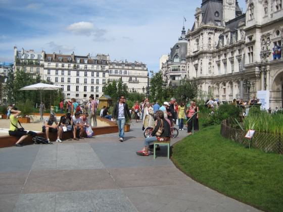
Open Mumbai: Re-envisioning the City and Its Open Spaces

by P.K. Das
Mumbai

Public open spaces as the basis of planning are an effective means to achieve critical social objectives in cities — an approach that engages citizens, leads to better quality life and ensures a more ‘democratic’, more equitable city. By achieving intensive levels of citizens’ participation we wish to engage and influence governments to devise comprehensive plans for public spaces and re-envision the city with open spaces being the basis for planning including the vast natural assets of the city. Read more…

MayahsLotCover
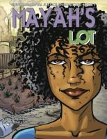
A Comic Book Sparks Kids Toward Environmental Justice

by Rebecca Bratspies
New York City

Our comic book, Mayah’s Lot, challenged students to translate their grade-school civic lessons into a real-world appreciation for how to use law to achieve environmental justice. The environmental justice curriculum built around Mayah’s Lot, helped these students cultivate not only an understanding of how public policy decisions are made, but also a keen appreciation for the points at which citizens can fruitfully intervene in that process. It taught them to use citizen science to generate data, and to make their interventions as persuasive as possible. Students began identifying environmental problems in their neighborhoods. Read more…

IMG_9402Cities as Refugia for Threatened Species

by Mark McDonnell
Melbourne

In our current efforts to create green, healthy and resilient cities and towns we (I include scientists, conservationists, architects, designers, planners, engineers, landscape architects, land managers, decision makers and teachers) have an obligation and the ability to create urban ecosystems that will support a diversity of organisms that can help preserve our natural heritage at local and regional scales. As a result of the research conducted by the staff and students of the Australian Research Centre for Urban Ecology (ARCUE) over the last decade, I believe we can move beyond living with a fairly common and limited pool of urban adapted species in our cities by explicitly creating urban ecosystems that provide habitat and resources for a diversity of organisms, including threatened species. Read more…

SchoolBiotopeTimelinePhotoKeitaroIto
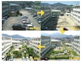
“Growing Place” in Japan—Creating Ecological Spaces at Schools that Educate and Engage Everyone

by Keitaro Ito
Kyushu

Where will children learn about nature? There has been so much building and development in Japan that we have lost open space and natural areas. So, where will children learn about nature? Where do they engage with the nature world? To solve this problem, we wanted to design biotopes within school grounds. These spaces would serve as both play and engagement areas. They also serve real ecological functions as natural areas. Read more…

LL
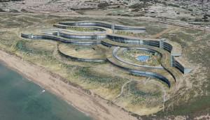
Architecture and Urban Ecosystems: From Segregation to Integration

by Kaveh Samiei
Tehran

Architecture is the profession of designing the built environment. But we architects should include the contributions experts in related fields like landscape architects, urban design and planning, permaculturalist, and policy makers. Each has a significant role in restoring balance between buildings, cities and our biological / ecological inventory. Surely ecological urbanism without ecological architecture is impossible. How can architects utilize ecological science to design cities and buildings which are in harmony with ecosystems? Read more…

SystemsInACityUrbanophilia and the End of Misanthropy: Cities Are Nature

by Mary Rowe
New York City

Fortunately, the life sciences have indeed come to our rescue in urban dialog, over time out-jockeying the mechanistic, linear-ists, persuading us in many aspects of living to look at what is generative, organic, connected to the whole. Jane Jacobs observed city life as inter-connected with the natural and built environments, and her ideas have prompted a contemporary approach to urbanism that integrates uses and users, green architecture and design, local economies (even currencies!), adaptive reuses, and ecological infrastructures. These reflect Jacobs’ recognition that cities — when permitted to — evolve naturally, adding form and function as needed. Jacobs’ method was a simple scientific one: to observe the particular, and extract from it her observations about how cities actually work. Read more…

GiraffeNairobi
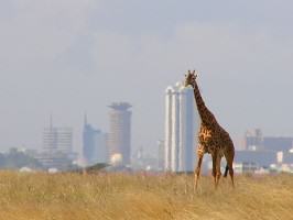
Re-imagining Nairobi National Park: Counter-Intuitive Tradeoffs to Strengthen this Urban Protected Area

by Glen Hyman
Paris

Nairobi is a bustling city of over 3 million people, many of whom are stuck in traffic for hours each day. One effort to mitigate these wasteful jams involves construction of additional motorways. But with little space specifically reserved for these new arteries, their proposed routes involve some delicate tradeoffs. One such road, the proposed Southern Bypass, is planned to run along the eastern boundary of Nairobi National Park. As presently designed, 150 acres of park land would need to be degazetted (i.e., lost) to accommodate the new road. Several nature conservation organizations have joined together to oppose the project, and a pending legal action has provisionally halted all construction. One might understand this story as a tale of local conservation organizations banding together to “hold the line” — protecting a parcel of wilderness from the bulldozers of urban expansion. But in an urban system as complicated as Nairobi, context truly matters. In fact, the project presents a rare opportunity, if leveraged aggressively, to expand and strengthen the integrity of Park while letting the Bypass go forward. Read more…

bronx river before after Photos NYCPArks
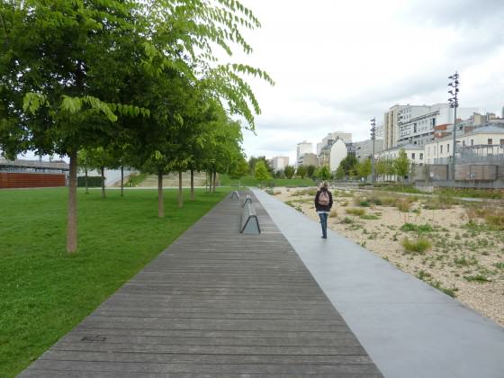
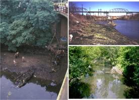
Up the Creek, With a Paddle: Urban Stream Restoration and Daylighting

by Adrian Benepe
New York City

I visited Austin, Texas to participate in the SXSW Eco conference. Staying across the street from Austin’s large and beautiful convention center, I was astonished to discover a green ravine immediately adjacent to the mammoth building, at the bottom of which was a slow moving creek full of small fish and a large turtle sunning on a rock. I soon learned that this was Waller Creek, a relatively short urban stream in a very highly developed area. I also learned that the stream is currently the focus of an ambitious public-private partnership to restore the stream and connect its banks with neighboring parks, creating both a recreational amenity and an ecological improvement. Read more…

SaoPaoloByFernandaDanelonIt Is Time to Really “Green” the Marvelous City

by Cecilia Herzog
Rio de Janeiro

We are living extremely intense and interesting days in Brazil, as in several other countries. People want to be heard and to be part of the game! In this historically peaceful country, suddenly masses gathered in the streets with more than 1 million citizens marching in one single day! And the protests continue. The problems are complex and quite intricate, but in my view, there is an important factor that is not being considered: people want to live in cities that are livable. Livable cities are those in which people matter and in which nature matters. During the last years I have seen how urban dwellers praise their trees and green areas, and how they are trying to protect them against creating cities “business as usual”, based on car-centric transportation and sprawl. I love when I go to urban parks and they are packed with curious and happy families, with people of all ages enjoying trees, birds, monkeys, squirrels, and flowers… and life! Read more…

West Hayden island  (c) Sallinger (3)Lessons from a One-eyed Eagle

by Bob Sallinger
Portland

Somehow it seems fitting that a one-eyed eagle calls West Hayden Island home. By all rights, the island should have been paved over long ago. Despite the odds, it somehow survived, decade after decade as the landscape around it developed. The odds are against it now too. The big money and conventional wisdom say development is inevitable — we need to prepare for the future. But sometimes the conventional wisdom is wrong; sometimes we need to think beyond the experts or perhaps seek out different sources of wisdom. Sometimes the path forward is written not in technical reports, but on the side of a canoe and in the stories of our fellow travelers, the stories that usually don’t make it into technical reports.

A one-eyed eagle is still a long shot. Not every bird survives. Not every story has a happy ending … but if she can fly, let her go. Let her have her freedom. Read more…


Rediscovering Eco-cities—Is this Possible in the Era of Globalization?

Art, Science, Action: Green Cities Re-imagined

Another revolution  the “ecological revolution” is required to go back and live in co-existence with nature.

Recently I have been to Auroville, an experimental universal township in Tamilnadu and Puduchhery of southern India. This was founded in 1968 by Mirra Alfassa known as “The Mother”. Auroville came to be known as a global village, as the prime motive behind this project is to demonstrate that people all over the world can live together in harmony. The project has received the endorsement from the Government of India as well as UNESCO. This village can accommodate a population of around 50,000 in the future. What struck me is the design.

The village area has been divided into three concentric zones. The inner most is the core  is the peace area. The area also has a lake to serve as a ground water recharge area. An adjoining circular area is divided into residential zones comprising 189 hectares, a zone for green industries comprising 109 hectares, an international zone (74 hectares) for a living demonstration of human unity, and a cultural zone (93 hectares) for research and other activities. The outer ring is the green belt, at present comprising 405 hectares, which has been successfully transformed from a wasteland into a green ecosystem. This zone has organic farms, dairies, orchards, etc., is also meant to be a barrier against urban encroachment, and finally meant to offset the human footprint. The village also extensively uses solar energy and has designed the buildings in such a way that they consume less energy.

Source www.auroville.org

Auroville is categorised as eco-city or sustainable city. Several examples of eco-cities exist in the world. Before the word eco-cities became fashionable in the modern era, India had several such historical examples.

Auroville is remarkably similar to what Kautilya has suggested way back in the fourth century BC on how a town or city should be planned. Kautilya is regarded as the father of political science. First and foremost, unlike the emphasis on GDP, the productive capital, Kautilya clearly recognised the role of forests, water bodies, and mountains etc as frontiers and collective wealth. The arthashastra recognised that waste (pollution) must be disposed in a proper way so as not to affect the environment. Arthashashtra suggests that the city be divided into four concentric circles. The main city is located at the centre and should have perennial source of water. Surrounding this central city are the villages located amidst the mixed land use — pastures, agriculture. Forests for recreation and economic benefits formed the outskirts of the settlement. The forest based industries are suggested to be located adjacent to the forests and settlement area. The forests in wilderness formed the outermost concentric circle and these have to be protected. These forests were occupied by tribes with traditional knowledge and enjoyed de facto rights on the forests.

00007
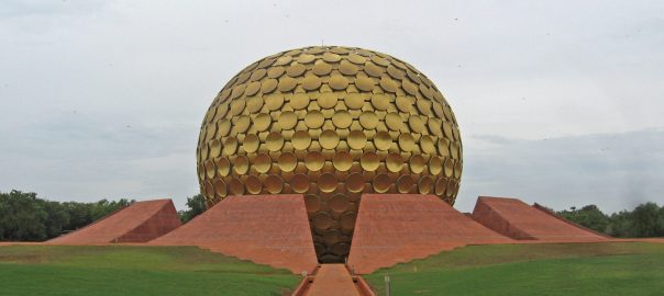
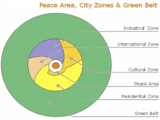
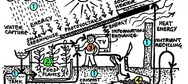
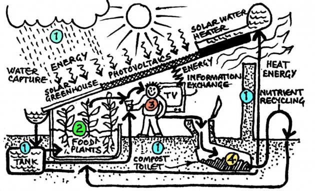
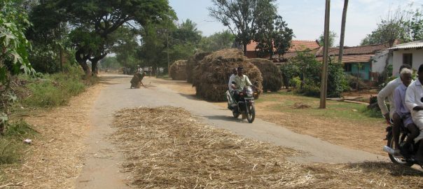
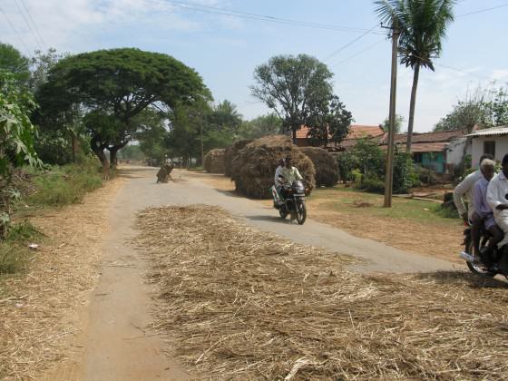
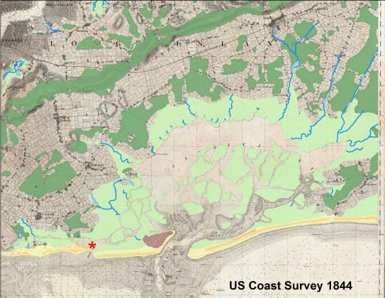
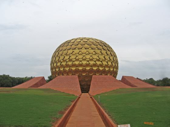
Thus, the importance of cities living in harmony with nature has been emphasised. The ancient Indian science Vastu shastra is entirely devoted to the science of architecture. Vastu shastra is a treatise on architectural planning, construction and design and emphasizes  the right selection of the site given the nature of slope, colour, strength of soil and the direction of the plot. Vastu emphasizes optimal utilization of five elements: earth, water, fire, wind and cosmic space for harmonious living. The key contention is that when we build something we are interacting with the positive and negative forces of nature and it is vital to have a net positive energy flow (called bio flow or Prana).

Depending on the shape of the plot and its size, several plans called Vastu Purusha Mandalas divided into four concentric zones were suggested. The innermost zone is called  Brahmastana, which is the place for total awareness. The next three circles in order represent Daiva (enlightenment), Manushya (consciousness) and Paisacha (grossness) respectively. The Brahmastana is always occupied by a temple or a palace, and the construction is suggested in the second and third zones. The ancient Indian cities of Pataliputra and Takshasila were constructed based on Vaastu principles. The modern Indian cities of Jaipur and Chandigarh and the temple cities of Tirupati and Madurai also follow Vastu principles.

So the history repeats itself. Now we have reinvented the same old philosophy of living in harmony with nature through the name of eco-cities or sustainable cities.

What are the key attributes of eco-cities?  These cities are designed as follows:

1)    Require minimal input from the rest of the world

2)    Transfers minimal externalities to the rest of the world

3)    They produce their own food, water and energy

4)    Rely on using local material and on the natural flow

5)    Have more wilderness and open spaces

6)    Use natural solutions for stabilising micro-climates and use renewable energy sources.

7)    Ideally they are smaller in size requiring less transportation of goods and services

8)    Eliminate all carbon waste

Transforming the existing mega cities into eco-cities may be difficult. However, building new eco-cities is quite possible. If we are successful in building the eco-cities, it is possible to make positive economic, social environmental and ecological impacts.

In this era of high population pressure is it possible to have zero carbon and ecological footprint? There are several cities in the world which are named as “eco-cities”. But do we have some certification process to validate the claims?

The reason why it is important to have this process set up is due to the ambiguity of the term “eco-city”. We live in the era of globalization, which involves goods travelling long distances. The trade happens due to comparative advantage. That is, if a product X costs less in country A than country B due to some natural endowments, it makes sense for countries to trade due to comparative advantage.

Now, if an eco-city limits its production and imports goods from outside the city zone, to whom should we assign the carbon and ecological foot print ? For example, a resident living in eco-city would like to consume apples, Kiwis or Oranges, but which are not grown nearby. He has to import apples, which involves some externalities. To whom should these emissions be attributed to? This may be same for the other materials which are not available locally say rice, wheat, vegetables, etc., or material required for building the eco-city. A resident in an eco-city may have to use textiles or leather goods which are highly polluting. To whom should this pollution be attributed? Are we also assuming that living in eco-city also means changing the consumption patterns?

In fact this is the situation in today’s era of globalization. We cannot think of ourselves as living in a Robinson Crusoe economy — a closed economy with no trade. We need to clarify the ambiguities surrounding the measurement of footprints associated with eco-cities.

Having few eco-cities might not make a very big difference to the world, as they still have to depend on the external world for things other than food, water and energy. However, this is nevertheless a positive change. But if we have several such cities connected with each other, it is probably possible to minimize their carbon foot print and ecological foot print.

Just imaging and designing an eco-city is not sufficient. We also need to change our mindset and attitude. This might require an “ecological revolution” to go back and live in co-existence with nature.

Haripriya Gundimeda
Mumbai

On The Nature of Cities 

Lessons from a One-eyed Eagle

Art, Science, Action: Green Cities Re-imagined

By all rights a one-eyed bald eagle is a doomed bird. Imagine trying to catch a salmon or a brush rabbit with no depth perception. Oh eagles will scavenge and occasionally steal food from one another, but roadkill and kleptoparasitism will only get you so far in life…or so the conventional wisdom goes. The one-eyed eagle that finds its way into captivity should be put out of its misery or relegated to life in a zoo. To release such a bird is to condemn it to a slow death by starvation.

West Hayden Island Bald Eagle. Photo: Bob Sallinger

Late on a Saturday afternoon in early November, shortly before Sunset, Portland Audubon’s wildlife hospital received a call about an injured bald eagle on West Hayden Island. The location was notable. West Hayden Island sits at the confluence of the Willamette and Columbia Rivers. Lewis and Clark camped here almost exactly 208 years to the day earlier on their journey to the Pacific. They called it “Image Canoe Island” after observing a Native American canoe carved with the images of men and animals emerging from behind the island. It was a place teaming with wildlife. Captain William Clark noted in his journal the following:

Rained all the after part of last night, rain continues this morning. I [s]lept but verry little last night for the noise. Kept [up] during the whole of the night by the Swans, Geese, white & Grey Brant, Ducks, etc on a Small Sand Island close under Lard. Side; they were emensely numerous, and their noise horid [sic].

Two centuries later, West Hayden Island represents one of the last intact remnants of this once fertile delta area. Its 800 acres of bottomland forest, wetlands and meadows, sit between the cities of Portland, Oregon and Vancouver, Washington. The surrounding river has been deepened, straightened and its banks hardened to make way for industrial development. Marine terminals line the banks to the north and south. East Hayden Island has been fully developed — nearly 750 acres of shopping malls, auto lots, high end condos and Oregon’s largest manufactured home community.

What little natural area that remains is an oasis for federally listed migrating salmon that require shallow water habitat to rest, forage and temporarily escape larger predators on their journey to the ocean. Its uplands provide habitat for a plethora of wildlife. Almost the entirety of West Hayden Island lies within the 100-year floodplain and during major flood events much of the island can be almost entirely submerged.

West Hayden Island with the Port of Portland Marine Terminals to the Right. Photo: Jim Labbe
West Hayden Island with the Port of Portland Marine Terminals to the right. Photo: Jim Labbe

It is also a battleground. For nearly two decades the Port of Portland and other industrial interests have fought to turn West Hayden Island into marine industrial terminal. Even as other downriver port facilities sit vacant awaiting tenants and teetering on the brink of failure, development interests in Portland argue that this is the last big parcel available for marine terminal facility development in Portland.

There are no tenants lining-up for West Hayden Island either; the Port can’t say what it will build or when it will be needed. A decade ago they thought it would be containers. Today the best bet is auto imports. It doesn’t matter. The important thing is to be ready future whenever it comes and that means annexing the island, rezoning it for development, filling its floodplains and waiting for the “next big thing” in the realm of imports or exports.

West Hayden Island Beaches with Port of Vancouver looming in the background. Photo: Bob Sallinger

On the other side of the issue, a loose coalition of environmental groups, neighborhoods and tribes have a different conception of what it means to be “prepared for the future.” Representatives of the Yakama Nation travel more than 100 miles downriver to testify against this development at hearings. In a letter dated November 6, 2012 they wrote:

What was true in 1905 — and for thousands of years before that — is still the case today and will be for the Yakama children yet unborn; salmon and the health of the Columbia River are of paramount importance to our people.

Yakama Nation and other Tribes testifying against development in 2012. Photo: Bob Sallinger

They are joined in their opposition by a manufactured home community — a trailer park in more common lingo — that has persisted more than 40 years adjacent to the natural area…high end real estate that somehow has managed to remain low income housing for more than 2000 people. In 2012, the City of Portland adopted a long range vision known as the Portland Plan which established equity as the city’s “core principle.” Hearing this, the locals rose up and flooded hearings demanding equity, although one self-described “grandma” admitted to me afterwards that she didn’t actually know what the term meant.

That’s okay, the city and port don’t really know either. It is a work in progress. From the Port’s perspective, equity equals jobs and a larger tax base. Our development community likes to talk about a three legged stool of economics, environment and equity. Funny thing about that stool though. Too often the economic leg is growing while the equity and environment legs are getting shorter. One should think twice before sitting on that stool.

In this case a small army of sign-waving “grandmas and grandpas” demanded something more substantive than metaphors, a Health Impact Assessment, defined by the Centers for Disease Control as “a process that helps evaluate the potential health impacts of a plan, project or policy before it is built or implemented.” The City agreed to do a truncated version called a “Health Analysis” — sort of a Health Impact Assessment “Lite”. The findings were not pretty. The final report revealed that, even with mitigation strategies in place, the proposed development would potentially triple air toxic levels to 55 times the state benchmarks in the local community. It also described the potential for development induced poverty and displacement in the local community.

Manufactured Home Community protesting development. Photo: Bob Sallinger

In fact the project has generated a small mountain of reports. The project website lists more than eighty such documents: Economic Foundation Studies, Cost/ Benefit Analyses, Mitigation Plans, Market Studies, Growth Concepts, a report on the viability of the black cottonwood forest, another on the value of floodplains…this list goes on. The goal is to find “balance.”

If we study it long enough and hard enough perhaps a win-win solution will materialize. It hasn’t. Some places are special. They shouldn’t be turned into parking lots.

Which brings me back to the one-eyed eagle. As the sun was sinking low in the sky, my eleven year old son and I drove through the tangle of sprawling development that now covers East Hayden Island, past the shopping mall and the convenience stores and the impossible to ignore and even harder to explain “Hooters” sign, past the auto auction lot and single story industrial office parks, and finally past the tidy manufactured home community. We met the hiker who had reported the injured eagle and together we headed out into the wilds of West Hayden Island.

We found her perched in a meadow a little over a mile from the gate, a big female, white head stark against the falling darkness. When I approached she leapt into the sky, but only one wing extended and she twisted awkwardly and dropped back to the ground. We quickly bundled her up in an old Mexican blanket I had brought with me and began the mile long trek back to the car. I wondered as we walked whether this eagle could be the eagle that a few years back had established a nest and began raising young in the middle of the proposed development area. We often featured that eagle in our efforts to protect West Hayden Island. Her picture adorns the banner atop our “Save West Hayden Island” Facebook page.

West Hayden Island Eagle on nest in 2013. Photo: Bob Sallinger
West Hayden Island Eagle in Flight 2012. Photo: Bob Sallinger

Our veterinarian met us at Audubon later that night and we gave her a full work up. In addition to the injury to her wing, she had fresh wounds on both of her legs. Most likely she was injured in a territorial dispute with another eagle — the most common cause of injury for eagles treated at our center. X-rays revealed that at some point in her life she had also been shot. A bb was still lodged deep in her breast muscle but by all appearances, it had been there for quite some time.

However the worst thing was the right eye. I couldn’t see it when we were carrying her through the darkness on West Hayden Island, but we all saw it right away as we unwrapped her from the blanket under the surgical lights of our treatment room. The right eye was badly damaged — beyond repair. As we worked to treat her injured wing and legs we knew in the back of our minds that she was most likely never going to return to the wild. It was sad. She was a beautiful bird, nearly 12 pounds, other than her injuries in perfect body and feather condition. We consulted other experts from around the country. They all said the same thing. She wouldn’t survive in the wild with one eye.

Eagle being examined on arrival at Audubon. Photo: Peter Sallinger

However sometimes conventional wisdom is wrong. A veterinary ophthalmologist surprised us a few days later when she confirmed that indeed the damage to the eye was severe, but also that it was old, many months old, perhaps years. This bird had most likely been surviving in the wild for quite some time and doing quite well despite the injured eye.

Audubon Staff Treating Eagle. Photo: Tinsley Hunsdorfer

Verification of her strange and unlikely journey came from an even more unlikely source. David Redthunder lives in the manufactured home community on Hayden Island. He spends much of his time communing with the wildlife that inhabits West Hayden Island. He has an uncanny ability to get close to the critters and he has a particular affinity for the nesting eagles. Sometimes when I visit the island, I find small shrines he has built to protect the birds.

Over the years he has sent me hundreds of amazing photographs he has taken of the island’s wild inhabitants including dozens of the eagles. (To see a gallery of David’s West Hayden Island Photos go here.) What were the odds that David would have captured an image of the injured eye? It seemed like a fool’s errand, but I opened the file of David’s photos on my computer and began scanning. About 30 photos along, I found it….a blurry photo dated August 12, 2012, the injury to the right eye clearly visible. The injury was more than a year old. She had not only survived her eye injury, but also apparently has successfully nested and raised two young.

Photo of West Hayden Island Bald Eagle with Injured eye on November 28, 2012. Photo: David Redthunder
Manufactured Home Community Protesting Development in 2012. David Redthunder in foreground holding picture of eagle. Photo: Bob Sallinger

More of David Redthunder’s West Hayden Island wildlife photos follow. To see more, go here.

Daves pictures 712Daves pictures copyNovember 7, 2012 012

August 15, 2012 038

Daves pictures 02208-04-2012 110 (2)November 3, 2012 017September 18 2012 011sprider web (3)
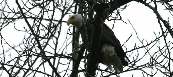
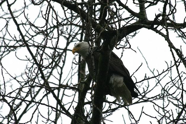
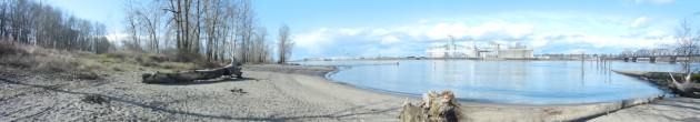
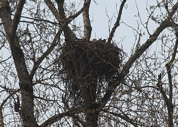
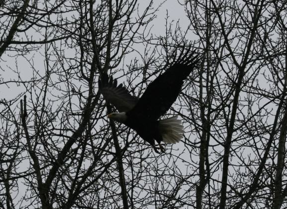
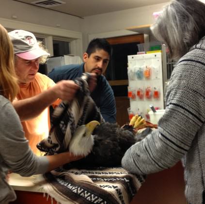
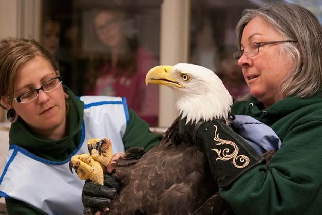
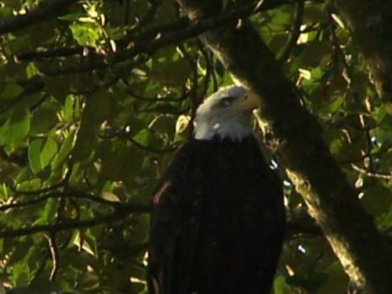
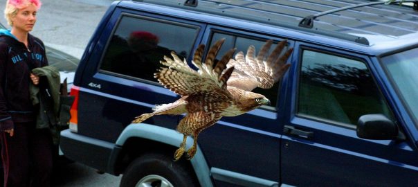
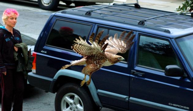
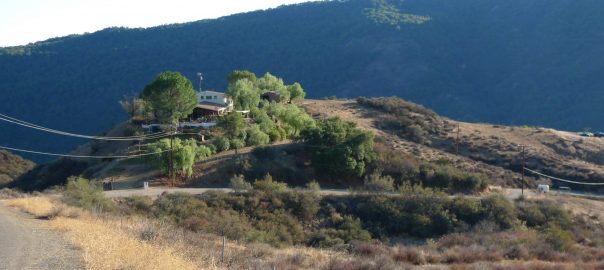
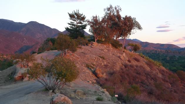
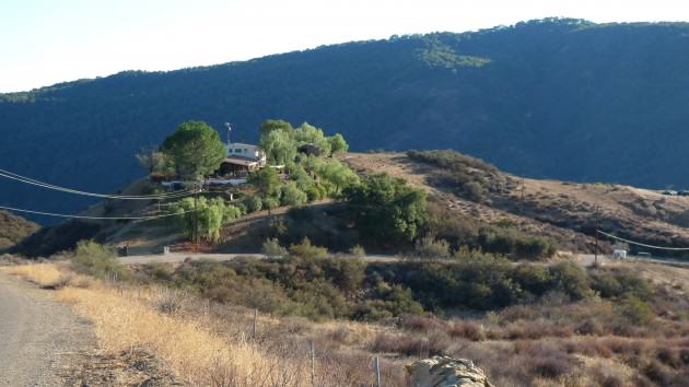
Somehow it seems fitting that a one-eyed eagle calls this place home. By all rights, the island should have been paved over long ago. Despite the odds, it somehow survived, decade after decade as the landscape around it developed. The odds are against it now too. The big money and conventional wisdom say development is inevitable — we need to prepare for the future. But sometimes the conventional wisdom is wrong; sometimes we need to think beyond the experts or perhaps seek out different sources of wisdom. Sometimes the path forward is written not in technical reports, but on the side of a canoe and in the stories of our fellow travelers, the stories that usually don’t make it into technical reports.

A one-eyed eagle is still a long shot. Not every bird survives. Not every story has a happy ending … but if she can fly, let her go. Let her have her freedom.

Bob Sallinger
Portland

On The Nature of Cities

Kids exploring West Hayden Island Grasslands. Photo: Bob Sallinger


.


What Does Urban Nature-Related Graffiti Tell Us? A Photo Essay from the City of Cape Town

Art, Science, Action: Green Cities Re-imagined

Graffiti, revered and loathed by turn, provides insights into societal attitudes and perceptions. In this short photo essay I present nature-related graffiti from the City of Cape Town.

Whether for protest, art, comment, or signaling, as an illegal activity graffiti always challenges hegemony.

Cape Town still bares the hallmarks of apartheid with significant race-based development and wealth discrepancies. It is situated in the middle of a global biodiversity hotspot. And, it will be the world design capital for 2014. This city has rich pickings for exploring and interpreting graffiti. Cape Town has all the standard expressions among its graffiti, including political commentary, personal or ‘existential’ commentary, gang-related territorial demarcation, basic tagging, the more elegant ‘piecing’ where tags or names are elaborate, and larger artworks that combine comment with a particular aesthetic.

Check out http://thenatureofgraffiti.org
Whether for protest, art, comment, or signaling, as an illegal activity graffiti always challenges hegemony. An examination of nature-related graffiti in Cape Town shows a number of emergent themes around the imaginings and recalling of rural nature in cities, political statements around conservation concerns of African mega fauna, nature as beautiful and aesthetically improving and informative of a better way of life, and simply bringing depictions of nature into cities where it might be otherwise absent to soften and beautify. Graffiti in Cape Town presents cities as counter to a rural idyll, the aesthetic form as non-nature, or aesthetically requiring the remediation which natural scenes can provide, as the site of the greatest populace where ‘armies’ can be called on to take up causes, in particular in the South African context, for conservation concerns.

So if we need to listen to people about their perceptions and views on nature in cities, in order that we better promote the idea and value of nature in cities, what does this graffiti tell us? It tells us there are voices of dissent out there, personal views not captured by popular media, or standard urban form, and a desire for more nature both in cities, and beyond cities.

A tour of Cape Town nature-related graffiti 

Much of what appears as nature-related graffiti is evidently to improve an otherwise harsh urban aesthetic. Depictions of trees, plants and animals add colour and soften hard edges and expansive blank walls.

Nature on my mindCreeping nature creeping consciousnessDistrict 6 deerThe following two examples depict boats tossing in stormy seas, a strong narrative of shared, collective history in Cape Town, which was originally known as the Cape of Storms. Even today ships run aground on the shores of the City every winter and this is an aspect of nature we all share and respect.

This notion of sharing and connecting through the visual in an urban space is enhanced here where a telecommunications engineer fixes a phone box adorned with a vase of flowers and the scene of a small boat approaching Table Bay in the high seas. Devil’s Peak, one of the major peaks of Table Mountain, can be seen in the background.

Telkom and cape of stormsCape of storms
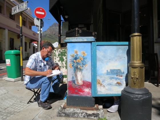
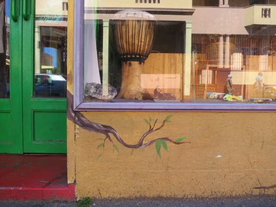
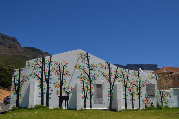
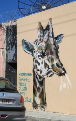
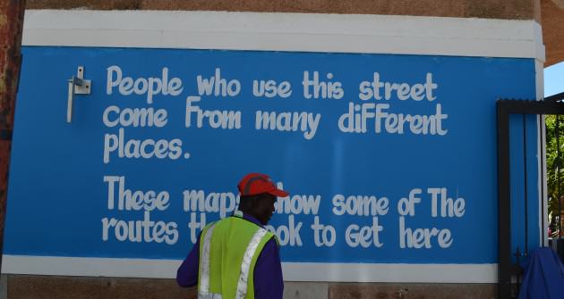
Pictures of African wildlife, not present in Cape Town for hundreds of years, litter the city, calling on the larger urban populations to take up these distant conservation causes.

CheetahGraffiti GiraffeSave the rhino girlTomorrow's Rhino
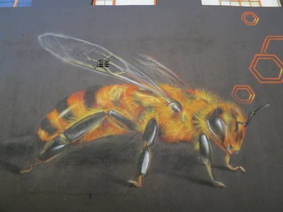
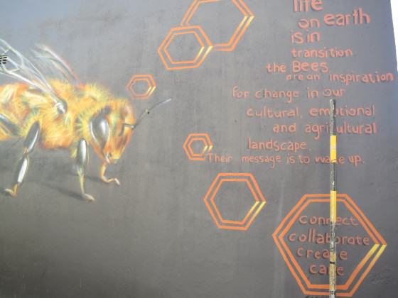
The following graffiti is regularly updated, keeping abreast of the shocking rhino death tolls due to poaching for the illegal horn trade in conservation areas far flung from Cape Town.

Positioned along one of the City’s major highways this graffiti is seen on a daily basis by thousands of commuters. The image of a car speeding past and the pedestrian makes you think about the intended audience, a critical element to graffiti, and how different personal experiences might affect how such messages are received.

Rhinos IIRhinos whose problem is it

Rapid urbanization, combined in the case of Africa with persistent rural-urban linkages, means that many city dwellers have strong ties to rural nature.

These two pieces of graffiti hint at a nostalgia for rural landscapes and livelihoods with noble cattle and abundant lands.

Rural livelihoods_cattle

Rural imaginings

As a cosmopolitan city, Cape Town is home to people from various places. The following two pictures, which sit side-by-side on a street in Cape Town, remind us of the diversity of cultures, experiences, and perceptions that make up our urban space.

No two end points on these maps will have the same nature. We all carry our own experiences of nature and our own expectations of nature into the city with us.

Maps of originsDifferent people know different natures

Some nature-related graffiti draws on nature to improve our urban existence. Here we are called on to learn from the bees and the plants.

Bee I Bees IIIPlants to heal and repair

Thanks to Jaques de Satage for taking these commissioned pictures so beautifully.

Pippin Anderson
Cape Town

On The Nature of Cities

See also: http://thenatureofgraffiti.org

For a paper on urban graffiti, see:
Urban Graffiti on the City Landscape
Alex Alonso
Department of Geography
University of Southern California

The Village within the City—Rurality in the Era of Globalization

Art, Science, Action: Green Cities Re-imagined

Popular descriptions of urbanization these days often describe humanity as having entered a “new urban era“, with more people living in cities today than they do in rural areas. Urban areas have a large footprint of impact on the rural countryside, and the line between the urban and the rural is particularly challenging to make in many parts of the world, where peri-urban areas, and even remote rural villages are dominated by the footprint of urban residents who extract resources from villages, pollute far away rivers and deforest remote landscapes, send remittances back to rural homes, and alter rural lifestyles towards more urban, consumptive behavior (Photograph 1).

Farmers in a rural Indian village spread a millet crop on the road, so that urban motorists can drive their vehicles onto the dried ears, crushing them to make it easy to remove the loosened grains. Thus, rural areas take advantage of their connection with cities to reduce the manual labor involved with manual threshing of crops. Photo: Harini Nagendra
Photograph 1: Farmers in a rural Indian village spread a millet crop on the road, so that urban motorists can drive their vehicles onto the dried ears, crushing them to make it easy to remove the loosened grains. Thus, rural areas take advantage of their connection with cities to reduce the manual labor involved with manual threshing of crops. Photo: Harini Nagendra

Policy makers and planners rely on hard distinctions between the urban and rural to devise strategies for urban planning, but such strategies are complicated by the fluidity between the rural and the urban.

Much attention has been given to differentiating the expanded footprint of the city on rural landscapes, through approaches such as the mapping of urban-rural gradients, that extend from the city center out past peri-urban and suburban landscapes to the rural environment. But equally common, though much less discussed, is the phenomenon of rurality within a city. The expansion of cities in many predominantly rural landscapes in Asia, Africa and Latin America has resulted in the city engulfing whole villages within its boundary, amoeba-like. These villages then exist within the city, often becoming converted to peri-urban slums with rural huts complete with livestock, co-existing next to affluent high rise apartments inhabited by software engineers. These areas tend to become the locus for rural migrants, leading to congestion in these areas coupled with high poverty and difficult living conditions. Such villages in the city are becoming increasingly common across Indian cities. Yetcity planners tend largely to ignore these areas, or at the most, term them urban slums. The dichotomous approach of the urban planner and the limitation of the discrete view of the urban vs the rural truly breaks down in such contexts.

In the Indian city of Bangalore, this is clearly apparent in areas within the city center, as well as at the periphery, where the influence of the rural is obvious. Many of the former villages located within Bangalore’s limits are easy to recognize based on obvious physical features such as the presence of rural style houses with thatched sloping roofs, the presence of Ashwath Kattes (Photograph 2), raised platforms around a sacred tree that create a central place for people to meet and talk, and the presence of livestock including cows and pigs in the heart of the city (Photograph 3).

Photograph 2: Ashwath kattes provide the central focus for a traditional village festival or jatre held annually in a village in Bangalore city limits. Attended by hundreds of participants from local villages, these festivals hold great cultural significance for these communities. Yet at the same time these traditional cultural practices are not immune to the forces of urbanization and globalization, with mass produced plastic toys being sold here alongside hand crafted wooden toys, and global icecream brands sold adjacent to local handmade snack foods. Photo: Harini Nagendra
Photograph 3: Livestock and people co-exist in one of Bangalore’s oldest neighborhoods, Basavanagudi, established as far back as 1897. Photo: Harini Nagendra

Thus, cities do not only undergo a one-way path towards increased globalization and homogeneity of lifestyles and livelihoods. Cities in many parts of the world, as far flung as Beijing, Mexico City, Kampala and Bangalore, exhibit forms of rurality that are uniquely, intensely local. We need new ways to conceptualize, examine, illustrate and manage such scenarios. Urban studies need to move well beyond discrete conceptualizations of the rural vs the urban — even, I would argue, beyond approaches that attempt to characterize urban vs rural gradients in linear term — towards more continuous, multi-variable approaches that can truly capture and illustrate the multi-faceted nature of rurality within the city in a manner that captures some of its true complexity, and provide a way to still retain the unique charm of the local within the rapidly globalizing city.

Harini Nagendra
Bangalore


On The Nature of Cities

Launching the Global Biophilic Cities Network

Art, Science, Action: Green Cities Re-imagined

Nature provides immense emotional, spiritual and health benefits to residents of cities. There is little wonder then as to why many of us in the urban planning and design fields see nature as central and essential to all that we do and to imagining the future of cities.

The concept of biophilia is at the core and argues that we have co-evolved with nature, and that we have a deep need to affiliate with the natural world. The human species has “grown up with nature,” as Harvard biologist E.O. Wilson has said. To Wilson, biophilia is understood as “the innately emotional affiliation of human beings to other living organisms.  Innate means hereditary and hence part of ultimate human nature.” It is thus not surprising that we are happier, more productive, more creative, and even more generous in the presence of nature. Nature in cities offers the promise of lives that are wondrous and connected, lives attentive to the natural magic around us.

Much of our work here at the University of Virginia has focused on connecting the urban and the natural and envisioning cities that contain bountiful and abundant nature and are committed to restoring and celebrating that nature, and to cultivating an urban ethos and populace that is profoundly connected to and cares about the nature around them—essentially what we have been calling Biophilic Cities (see Beatley, 2011).

From October 17-20, 2013, we convened an impressive group of urban leaders from around the country and the world here in Charlottesville at what we called our Biophilic Cities Launch. The conference was a significant step forward for our work developing the concepts of biophilic cities and biophilic urbanism, and extending and applying these concepts around the world. It was a culminating event, celebrating two years of collaborative research and work, but also a Launch event looking into the future of taking on the task of imagining and designing a larger network of cities and interested individuals and groups around the world willing to embrace and move forward the idea of biophilic cities.

The Biophilic Cities Project, underway for several years at the University of Virginia, stems from the essential premise that nature is absolutely essential to urban life. Biophilic cities must provide opportunities for daily contact with nature and deep connections to the natural world for citizens to be happy, healthy, and productive and to lead meaningful lives. Funding for the initial two-year research and for the conference and launch events was provided by the Washington DC-based Summit Foundation, in addition to the George Mitchell Foundation.

It was a most stimulating four days, attended by at least three fellow TNOC blog writers (Mike Houck, Lena Chan, and Cecilia Herzog). Panelists shared a mix of presentations about the innovative work of cities, the immense challenges (political and otherwise) they face in giving nature priority in their planning and design and a host of practical and innovative ideas. There were workshops, earth walks, a biophilic cities exhibition, and many, many productive and stimulating conversations over meals, walks and breaks between sessions.

Much of the work of the Biophilic Cities Project has focused on certain cities around the US and the world. In these “partner cities,” and through collaboration and information sharing, we have been able to assemble similar GIS and data layers across the cities, and to understand the detailed programs, policies and projects advancing biophilic urbanism in these cities. We have conducted site visits to partner cities, and have also been working to document the innovative urban nature projects in these cities, and the variety of tools, techniques and planning strategies utilized in protecting and incorporating nature in these cities, and in fostering connections with the natural world. One key goal of the Launch was to allow and encourage these cities to share their stories and insights and begin to help each other to better integrate nature into their planning and management.

Our partner cities, and cities we have been actively studying, have included a wonderful mix of cities actively fostering connections to the natural world, including: San Francisco, California; Portland, Oregon; Milwaukee, Wisconsin; and Phoenix, Arizona in the US, and Singapore, Vitoria-Gasteiz, Spain; Oslo, Norway; Birmingham, United Kingdom; and Wellington, New Zealand. Representatives from Rio de Janeiro, Brazil; Perth, Western Australia; and Montréal, Canada also joined the launch event and were included in the Launch exhibition, with the hope that we will begin to include them in our work as well.   Attendees came from cities all over the US and beyond, including St. Louis, Missouri; Boston, Massachusetts; Houston, Texas; Stockholm, Sweden; Washington, DC; Seattle, Washington; and elsewhere. The event was extremely well organized and managed by an incredible team of faculty, staff and students at UVA, with Julia Triman, graduate student in Urban and Environmental Planning and Carla Jones, Project Manager and Instructor leading the team.

The first two days of the Launch provided partner cities the chance to present their good work, and a rather amazing and exciting set of urban nature stories emerged. An initial panel addressed ways that universities might help in advancing biophilic cities. Jana Soderlund from Curtin University in Perth, Western Australia, discussed the innovative Green Skins initiative, spearheading the installation of green walls around the port city of Fremantle, and her preliminary research assessing their reception and impact on local residents.  Jana’s work is providing significant insights about what urban residents like about green walls. Her preliminary survey results show, among other things, that respondents tend to emphasize the beauty of these walls. Craig Thomas, from Arizona State University, discussed the ASU-UVA educational collaborative that has allowed several classes of honors students to analyze Phoenix neighborhoods against the metrics and concepts of biophilic cities. Kelly Hare, from Victoria University in Wellington, NZ, one of our partner cities, described the successful “halo” initiative, helping residents of that city living in close proximity to the innovative urban park and restoration project called Zealandia (a piece of wilderness in the city, where through a mammal-proof fence, native bird species such as Kaka parrot are rebounding dramatically).

We had two rousing and stimulating keynote addresses that helped push our collective thinking in important ways. An evening lecture by Jennifer Wolch laid out a Biophilic Cities “Manifesto.” Provocative and thoughtful, Wolch challenged us to think carefully about the many different and often marginalized interests (people and animals) that must be taken into account, and the potential “collisions” she sees in the movement. We must be careful, for instance, that urban greening projects like New York City’s Highline do not result in displacement and exacerbate unequal access to nature, and we must find creative ways to take full account of all species impacted, what she referred to as an “Intersectional Transspecies Urbanism.” Proponents of biophilic cities must think more about governance issues, and about the ethics of urban consumption as is impacts global nature. [You can watch the Jennifier Wolch lecture here.]

Kellert’s talk continued some of these themes,  presenting the evidence and evolutionary logic for biophilia and arguing that that biophilic values “need to be nurtured and developed through learning and experience.” A strong advocate for the power of biophilia, Kellert challenged us to work to shift our values,  culture and consciousness away from domination, disconnect, and transcendence of nature, to a paradigm of design and planning that understands contact with nature as essential and” deeply rooted in human biology”. He spoke of the special importance of aesthetics and beauty as biophilic values, and connections to nature.  Kellert put forth at the end a set of Biophilic Urban Propositions at the end (using his own city of New Haven as an example), that explained location, livability and future thriving based on natural features and conditions. He later signed copies of his newest book, Birthright: People and Nature in the Modern World. [You can watch the Stephen Kellert lecture here.]

Friday panels provided an array of compelling examples of urban commitments to nature and biodiversity. The first morning panel addressed urban compactness and nature. Matt Burlin of Portland, Oregon described the many impressive urban greening efforts there, including the some 1,300 green streets, examples of that city’s innovative approach to stormwater management, and he ended with video of the thousands of residents watching and reacting to the spectacle of tens of thousands of migratory Vaux’s Swifts descending down the chimney of a city school.

Rebeca Dios Lema described the history of efforts in Vitoria-Gasteiz, the capital of the Basque Country of Spain, and a recent Green Capital City of Europe, to restore nature and to establish its green ring, and more recent efforts to extend that ring into the interior of this very compact and walkable city. Finally, Lena Chan, Director of the National Biodiversity Center (and a TNOC blogger!) descried the many impressive efforts of Singapore to implement its vision of itself as a “City in a Garden.” These efforts include promoting Skyrise Greening, an innovative Park Connectors network, and support for the creation of community gardens and green schools, among many others. She also reported on Singapore’s Comprehensive Marine Biodiversity Inventory (which is about halfway completed), and Lena tells me that already they have discovered some 64 new marine species (i.e. species not known to science).

A second late morning panel “Urban Nature on the Edge” provided equally impressive stories of the efforts to conserve and enhance nature in San Francisco, California, Wellington, New Zealand, and Rio de Janeiro, Brazil. Peter Brastow, the City of San Francisco’s Senior Biodiversity Coordinator and Scott Edmondson, from the city’s planning department, together described this city’s major ongoing and emerging efforts, including a vision for connecting parks and natural areas within the city, and restoring native habitats. Several areas of innovation were discussed, including the city’s urban forest management plan, Green Connections initiative (planning and improving some 24 routes by which residents can reach nature in the city), and the city’s new Biodiversity Program. Particularly impressive are the many examples of community-based stewardship in the city. Together these efforts will allow the city to shift its vision from “Park City” to “Wild City.”

Amber Bill, who heads Wellington’s Our Living City Programme, described that city’s impressive efforts, including its town belt and green belt, and new emerging idea of a blue belt, that would encompass the harbor, marine reserve, and other marine and water environments. Finally Cecilia Herzog (another TNOC blog author!) discussed the impressive nature of Rio de Janeiro, the efforts of her NGO Inverde (for instance in the design and planning of the Olympic Green Corridor), but also the sobering difficulties faced in advancing an urban nature or urban ecology agenda in that city (with relevance certainly to other cities).

The afternoon panel saw efforts in three more cities described: Milwaukee, Wisconsin, Montréal, Canada and Birmingham, United Kingdom. Here the focus was more on how nature might be enhanced and reinvigorated in older cities. Matt Howard, Environmental Sustainability Director for the City of Milwaukee, described many initiatives there, including continuing efforts to restore the city’s rivers with new efforts focused on the Menomonee River (and an impressive new Urban Ecology Center and park opened there). Montréal has recently completed its first biodiversity action plan, which Sabine Courcier described, along with other urban greening innovations there, including the city Green Alleys program. Finally, Nick Grayson described Birmingham’s innovative planning efforts connecting a number of public health concerns (air pollution, urban heat, poverty) with a vision of how the city’s natural assets (e.g. its network of small streams) might be harnessed to address them and to reduce overall chronic stress.

A key goal of the conference and launch was to provide opportunities for partner cities to share insights about work and experience, and to begin to develop personal and institutional relationships that will lead to future sharing and collaboration. That seems to be very much what happened, with attendees sharing stories and ideas over the course of the event, and forming friendships and developing plans for future interactions and collaborations.

DSC_0475BiophilicCities1
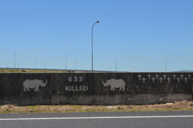
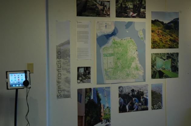
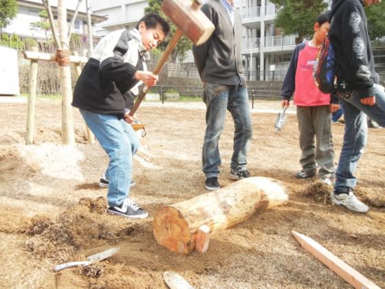
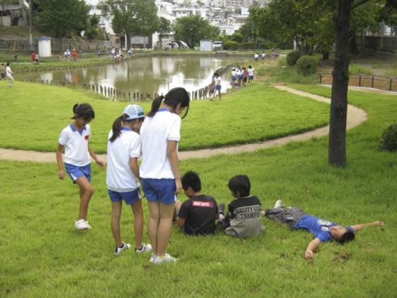
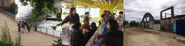
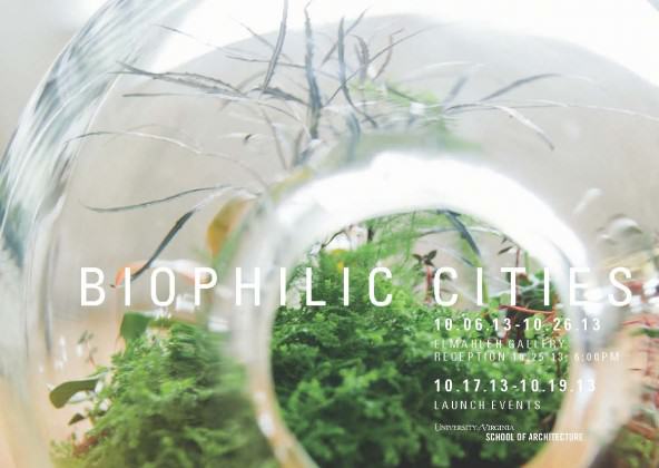
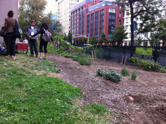
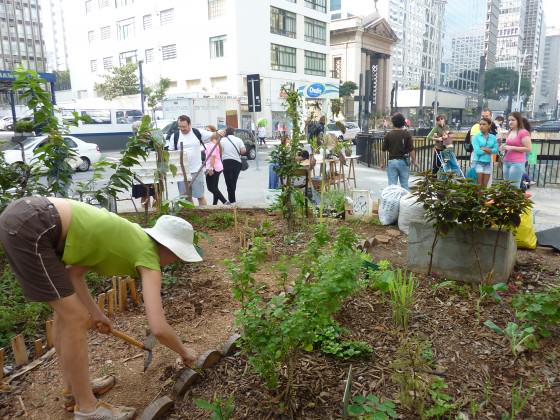
In addition to the main city presentations on Thursday and Friday, there were a number of side events, earth walks, and workshops for participants and the general public. These includes walking tours of the Dell Stream Day-lighting project on the UVA Grounds and the Meadow Creek Stream Restoration Project (in the City of Charlottesville, a collaboration of the city and The Nature Conservancy).

On the first day of the conference a workshop on green walls was jointly organized and run by Jana Soderlund, from Western Australia, and two graduate student members of the UVA Biophilic Cities team: Mariah Gleason and Amanda Beck. The graduate students, as part of the Launch and exhibition, built a clever, rollable green wall, from wood palettes (see below). They explained this design and have prepared how-to instructions for others interested in building a similar structure, which can be found here. Jana discussed in more detailed her efforts in Fremantle, and at the end, Launch participants joined together to plant several additional (commercial) mountable green walls, which once planted became part of the biophilic cities exhibition.

photo_JPGOne of my favorite events had to do with ants. We were joined for most of the launch by an entomology post-doc from North Carolina State University, Amy Savage. On Friday, during the bulk of our presentations from partner cities, Amy was busy setting out ant bait (including such things as Snickers bars, tuna, and pecan Sandies), attempting to see just how many species of ants she might find in and around the UVA School of Architecture. She was quite successful and discovered 13 different species in short order, in close proximity to where we were meeting. Education about this ant diversity, the habitat we were sharing that day, became something we attempted to weave into the more formal meeting and power point presentations. With Amy’s help at several points during the day we interrupted the Launch presentations with a report on what species had been found. We also produced a series of five ant collecting cards, with images of ant genus on one side and information about biophilic cities on the other side.

AntCard_1
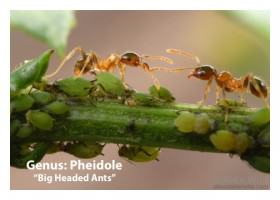
The incorporation of ants provided a visceral demonstration on the ways in which nature, much of it small and difficult to see, is all around us in cities. There is immense wonder and fascination value in ants, of course, yet urbanites are not well educated in looking for, identifying or even visualizing their existence all around us. Amy works with a wonderful initiative called the School of Ants that seeks to engage citizens in the collection and identification of ants throughout the country. They have produced a highly valuable urban ant identification guide, copies of which were distributed during the Launch.

AntCard_2
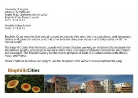
On Saturday afternoon, Amy took the ant station, including her microscope, to the Charlottesville Downtown Mall, engaging children and families walking by about the ants around them—something we called the Urban Ant Safari! In her interactions with people on the downtown mall Amy asked people to write down memories and recollections they had about ants in their past. She later compiled and shared these with us, and some were quite moving. An older woman wrote a note about her days as a child in England during WWII. She wrote, ‘When I was an evacuated little girl of 5 in WWII Britain, I used to watch ants. I dreamed of having a see through container, so that I [could] watch them work.’

On Saturday evening, John Hadidian, Senior Wildlife Scientist with the Humane Society of the United States, presented ideas for human-wildlife coexistence in cities, passionately arguing for tolerance and understanding, and offering a number of examples of approaches and strategies for co-existence and non-lethal resolution of conflicts.

On the final day of the Launch, participants traveled to Washington, DC, to paddle up the Anacostia River on canoes. Hosted by the Anacostia Watershed Society, participants saw an unusual side to that capital and the hidden nature, from abundant cormorants to sunning river water turtles.We learned about green rooftop subsidies, and other efforts to green the City of Washington and areas around the Anacostia River.

One major premise of the Project has been the power of telling stories about nature in cities through still images and film. In pursuit of the latter goal, several short documentary films have been prepared about our study cities, with several premiered at the Launch event. Indeed, Friday evening became our biophilic cities film night (which we kiddingly referred to as the first annual Biophilic Cities Film Festival). The feature film was Stephen Kellert and Jim Finegan’s beautiful hour-long documentary Biophilic Design (featuring several Launch attendees, including Bill Browning of Terrapin Green). The film presents a dizzying array of projects and sites, with a heavy emphasis on buildings of various kinds and the biophilic powers they deliver.

Four biophilic film shorts were premiered, as well, three telling the story of partner cities. These included films about Singapore, Wellington (NZ), and McDowell Desert Preserve (in the urban environs near Phoenix). A fourth short film told the story of the restoration of Meadow Creek in Charlottesville, Virginia. These are now on YouTube, and available to view:

VideoLeft

VideoRightTaking place alongside the conference and launch we also organized a major Biophilic Cities Exhibition in the UVA School of Architecture’s largest exhibition space, the Elmalah Gallery. With mounted images and text about each partner city, largely provided by participant cities, and consistently formatted maps presenting the comprehensive nature in each city, the result was a spectacular picture of the many different ways in which nature can be planned and designed into urban areas. Along with still images, film and video were available on stands with mounted iPads. Two of our graduate students, Sarah Schramm and Harriett Jameson had a major hand in designing and installing the exhibition.

One of the most interesting features in the exhibition was a beautiful glass terrarium, which we commissioned from the design firm Crooked Nest, based in San Francisco. Our UVA team designed and built an equally beautiful biophilic table made from recycled wood and steel. The wood table top was routed to convey the pattern of a water ripple, with the terrarium placed in the center of the ripple, as if it had just fallen from above.

The terrarium quickly became known locally as the “’biophilic bubble!” It is quite arresting and soothing in the small nature it provides. A fitting piece of the exhibition, the bubble graced postcards and publications announcing the exhibition and conference and became a kind of symbol for the importance and potential of small natural elements to deliver some of the power of nature. Stephen Kellert reminded us at several points of the importance of considering the kinds of nature that might be brought into indoor and interior spaces, recognizing that more than 90 percent of our typical day is spent inside (despite efforts to get us out of doors). Planning and design of biophilic cities ought not to forget the impact and value of bringing nature inside as well, where we can.

biophilic cities postcards_Page_1Biophilic bubble_JPG
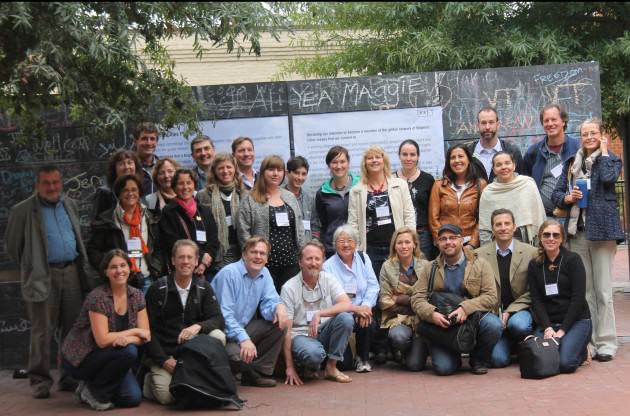
On Saturday morning a smaller group, mostly partner city representatives, came together to participate in a workshop to discuss and invent the new global Biophilic Cities Network. For several hours we discussed and debated key questions about what the Network could or should look like, what functions it will serve, what value it will have, and how and in what ways it might meet needs not served by other networks that exist.

There was considerable enthusiasm for the network and at the end of the meeting as a symbolic gesture and show of support participants went outside and signed a blown-up version of the Biophilic Cities Pledge Card. Meant very much as a draft and work in progress, we have already revised and amended this card, but here is the card as we discussed it that day.

Pledge_1 Pledge_2PledgeGroup
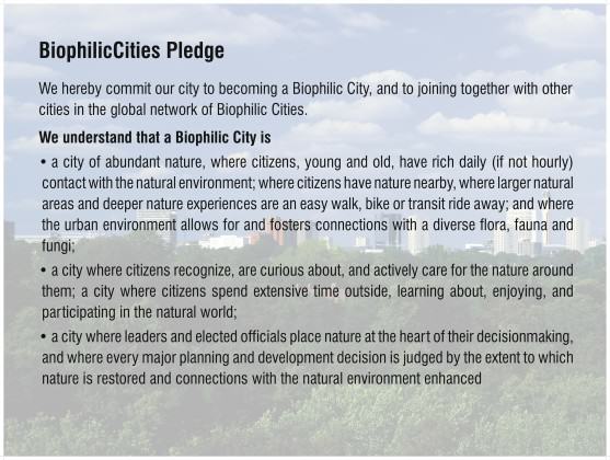
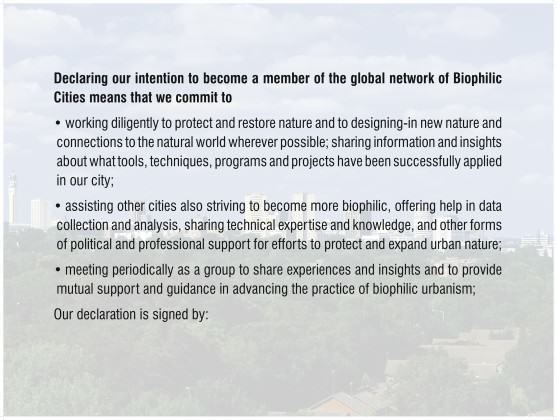
One of the most useful parts of our discussion had to do with what value of such a global network and how it would serve to strengthen the position of those in and outside city government working in support of nature. Some participants emphasized the importance of different local departments breaking out of their silos and that the network might help to do this. Others noted that the pledge card seemed to envision participants and signatories as primarily local council or local governments, but that left out universities, NGOs and many others with a stake in the network but working outside the city government.

One of the most interesting ideas is that the network might serve as a focal or organizing point for nature across a city and across the sectors of that city. This is something that had not occurred to me that in addition to the global network linking cities in different places and regions it might also serve to link disparate interests and actors within a city (and then perhaps linking these local constellations across the globe!).

There is still much to be done, as we near completion of our two-year Summit grant and look to the rolling-out of the global network. Key deliverables for the project will include a case book of best urban practices, including analyses of the accomplishments and urban-nature innovations in each city. We are also developing an urban-nature index as an aggregate measure of connections to nature, and as a way of comparing exposure to nature across cities. Other pieces of this work we hope to complete include a Delphi study through which we hope to be able to offers insights about the minimum daily amount of nature needed in cities. And of course we will continue to maintain and expand our Biophilic Cities webpage, blog, and e-newsletters.

Please stay tuned as we determine the exact language and mechanisms through which cities can declare their intentions to be a biophilic city (some version of the pledge language above) and participate in the Network.

We hope to grow this network into a global force on behalf of nature in cities and we will need your help!  If you or your city would like to join the Biophilic Cities Network, please send us an email: [email protected].

by Tim Beatley
Charlottesville

On The Nature of Cities

Money for urban biodiversity is scarce. What is the single most important idea, program or action any city should undertake to promote biodiversity?

Art, Science, Action: Green Cities Re-imagined
Regularly, we feature a Global Roundtable in which a group of people respond to a specific question in The Nature of Cities.
show/hide list of writers
Hover over a name to see an excerpt of their response…click on the name to see their full response.
Pippin Anderson, Cape Town
Two areas where I would spend my limited budget: on research towards really understanding the workings of biodiversity in cities, and then in exposing more urban citizens, in particular the young, to urban biodiversity.
Peter Werner, Darmstadt
Bring citizens more in touch with urban nature and urban biodiversity using components and methods — including values, incentives, demonstrations, etc. — that match urban lifestyle.
Andre Mader, Montreal
Cities are new competitors for the finite pots of global biodiversity funding.
Bram Gunther, New York
In New York City, the single most important biodiversity program recently has been the creation of the Natural Areas Conservancy (NAC), a non-profit that works in partnership with the New York City Parks Department.
Ana Faggi, Buenos Aires
Recently Buenos Aires has begun a significant transformation in order to revert the lack of green spaces and the reduction of its natural capital.
David Maddox ,New York
The single most important need isn’t in science, but in communication.
John Kostyack, Washington
Sustainability no longer quite captures what is most needed in today’s urban environments.

Pippin Anderson

We know biodiversity in cities is a good thing. For example we have research that shows a diversity of plants provides a similar variety of livelihood options to the urban poor, some sequester carbon with a close-to-source efficiency, and others retain soil. Multiple options allow for more choice for gardens for functional and aesthetic ends. Biodiversity provides a diversity of services. We also know that people in cities govern the globe and are responsible for a sustainable future, one hinged on the preservation of global biodiversity, so it is critical that people in cities value biodiversity. Here is what we don’t know so well. We don’t know the exact workings of many of the functions or services provided by biodiversity in cities. We know some, but in truth we are just scratching the surface. We also don’t know how to really give biodiversity traction with the people who live in cities, especially in the face of significant development pressures. So, these are the two areas where I would spend my limited budget: on research towards really understanding the workings of biodiversity in cities, and then in exposing more urban citizens, in particular the young, to urban biodiversity. If the budget was really limited I would go for the second as my single action. We are sentimental creatures and hold dear what we were exposed to as children. If all we achieve on our limited budget is a growing urban population coveting biodiversity the money for the rest will follow.

Peter Werner

My message is to bring citizens more in touch with urban nature and urban biodiversity using components and methods — including values, incentives, demonstrations, etc. — that match urban lifestyle. And, urban nature provides a lot of opportunities for such components. If you present nature in cities in a way that people only links it with a rural lifestyle, with sanctity, with closed borders, and so on, then you have no chance in urban areas because urban life is the opposite of that. Here is a list of words with which the citizens of a city can be connected with urban nature and urban biodiversity: perception, awareness, appreciation, literacy, curiosity, enjoyment, excitement, surprise, astonishment, emotion, spontaneity, freedom, encouragement, integration, inclusion, involvement, participation…Wording is critical in the dissemination of messages. Notice the words I am not using in this context After the wording, activities have to follow, and here too, activities are needed which represent the sense of urban life. The new media do that best. The challenge is to include urban nature in social networks, video portals, and games (serious games) and to produce urban events and performances about urban nature, not at the edge but in the center of a city, where more people can experience them. If urbanites discover and include urban nature as part of their life, then you save public money, because biodiversity in the urban matrix will be ensured and the governance can concentrate its activities on special nature conservation projects in which rare and endangered species will be protected.

Andre Mader

about the writer
Andre Mader

Andre is a conservation biologist specializing in subnational implementation of the Convention on Biological Diversity, seconded to the Secretariat for a third year by ICLEI. FULL BIO

Andre Mader

Cities are new competitors for the finite pots of global biodiversity funding. Funding is still undoubtedly lacking elsewhere, but biodiversity in cities deserves special attention due to its extraordinary “investment” potential to influence every aspect of biodiversity conservation at every scale by affecting, en masse, people’s (voters’) attitudes. I therefore believe that the biggest bang for biodiversity buck is through the opportunity, in cities, to reach multitudes of people with a subtle but concentrated conservation message. Nothing can do this in a more reliable way than the good old zoo (and/or, in many cases, the aquarium or botanical garden). These institutions can be accessed by unprecedented numbers of people, who have flocked to them for centuries knowing that they can expect an entertainment-intensive experience. There are also “bad old zoos”, and it is critical that entertainment is subtly embellished with messages so that the experience is also an education-intensive one. Of course zoos offer the additional function of ex-situ conservation and possible reintroduction. Not insignificantly, due to their proven popularity, they are also among the few conservation options that can be net money makers and it is therefore not hard to get the private sector involved. Zoos are therefore worth the considerable cost of their establishment and even more worthwhile investing in when all that’s required is to enhance existing ones with improved interpretative facilities and improved accessibility by all sectors of the citizenry. Local governments, which commonly own or manage these institutions, would do well to consider these options, and many already do to great effect.

Bram Gunther

about the writer
Bram Gunther

Bram Gunther, former Chief of Forestry, Horticulture, and Natural Resources for NYC Parks, is Co-founder of the Natural Areas Conservancy and sits on their board. A Fellow at The Nature of Cities, and a business partner at Plan it Wild, he just finished a novel about life in the age of climate change in NYC 2050.

Bram Gunther

In New York City, the single most important biodiversity program recently has been the creation of the Natural Areas Conservancy (NAC), a non-profit that works in partnership with the New York City Parks Department (Parks). Parks’ Natural Resource Group is the oldest urban conservation unit in the nation, started in 1984. The management of natural areas has become critical as the City faces climate change and seeks to increase public health. The City, however, will always have limits on conservation funding. In its organization and business model, the NAC capitalizes on present-day concepts of collaborative governance and the flexibility and effectiveness of public-private partnerships to enhance and expand current conservation work. The fundamental principle of the NAC is to increase the quality of the information flow between land management and design, researchers, and decision-makers. To this effect, the NAC is funding the first ever citywide ecological and social site assessments of Parks’ natural areas, data that will be used to guide and prioritize our conservation endeavors. NAC is expanding programmatic work by funding a hydrological engineer, additional foresters, and the expansion of our Native Plant Center to grow marshland and beach plants which will be used to make our coastlines more resilient. The NAC represents a significant change in urban natural resource management, from a focus on isolated plots to a single unified ecosystem and administrative whole. The NAC is emblematic of how urban ecological management will be done in the future: public/private partnerships.

Ana Faggi

about the writer
Ana Faggi

Ana Faggi graduated in agricultural engineering, and has a Ph.D. in Forest Science, she is currently Dean of the Engineer Faculty (Flores University, Argentina). Her main research interests are in Urban Ecology and Ecological Restoration.

Ana Faggi

Recently Buenos Aires has begun a significant transformation in order to revert the lack of green spaces and the reduction of its natural capital. The City Council worked a territorial model towards 2060 for a healthy and livable urban fabric with strategies to strengthen and recover the relation between Nature and the City. These includes the creation of new parks, squares and green corridors and the improvement of existing green areas including the rehabilitation of a 370 hectares big urban reserve located down town. In scarcity times of remnant areas with potential to become parks, as well as money that can be applied to the creation of new spaces, the local administration should make possible that vacant private lots could be at least temporarily used as new green community spaces. These could be designed, built and managed by NGOs, schools, universities, groups of pensioners, etc., devoted to urban agriculture or environmental education until the owner decides the lot construction. When this happens the builder should mitigate at the place the loss of nature with green terraces or walls. Buenos Aires’ strategy is to connect new and existing public green space through a structure of green corridors is adequate, because it regenerates permeable urban surface and increase biodiversity. Nevertheless, the attention should be placed not only on trees, but on shrubs, herbs and vines to preserve the Pampas ecoregion characterized by herbaceous components. This could apply to covered part of the sidewalks in order to increase groundcover today nonexistent in the city.

David Maddox

about the writer
David Maddox

David loves urban spaces and nature. He loves creativity and collaboration. He loves theatre and music. In his life and work he has practiced in all of these as, in various moments, a scientist, a climate change researcher, a land steward, an ecological practitioner, composer, a playwright, a musician, an actor, and a theatre director.

David Maddox

I was in a meeting a few months ago and someone put up a picture of a bioswale and said: “What’s this? It’s not a park. It doesn’t function like one!” Well, the bioswale is functioning exactly as designed: to collect stormwater. It does other things too, such as be a pretty patch of green and support biodiversity. But my colleague, who is a design professional, wasn’t aware of this. Many of us agree that nature in cities is good for cities and people. Biodiversity and nature provide formal ecosystem services and less tangible biophilic services. The professionals — mostly — know this. We have made the case less well with urban dwellers more broadly, who are rightly concerned about jobs, safety, transportation, livability, walkability and so on, maybe in that order. Many, even most, think of nature as irrelevant to their everyday lives. Others think of nature as “somewhere else”. To me, the single most important need isn’t in science, but in communication. We need to better make the connection between people and urban nature. Such awareness would trickle sideways to other residents, upwards to policy-makers, and akimbo to design professionals. How do we do it? We need to collaborate more with artists, exhibit designers, and media minds to make real use of demonstration projects, art installations, and pop-up messaging. How about a pop-up demonstration ecosystem in a city square? Paris’ City Hall did one recently. Washington, D.C. storm drains have painted signs that tell you that the site is part of the Chesapeake Bay drainage. How about a sculpture of a fish swimming through a building, as in Portland? How about an explanatory sign on the bioswale? Most fundamentally we need not to just “educate”, but engage, to find ways to reach beyond the groups we usually talk to and expand the dialog to include people who might not see things the same way. To do this we’ll have to find new ways to communicate, and find new collaborators outside our disciplines, and maybe outside our comfort zones.

John Kostyack

about the writer
John Kostyack

John Kostyack is VP for Wildlife Conservation at the National Wildlife Federation. His focus is restoring ecosystems to help reduce harmful climate change impacts. FULL BIO

John Kostyack

Resiliency is the Hallmark of Local Leadership, Wildlife conservationists should celebrate leaders, such as those in Curitiba, Brazil, who have achieved conservation results under the banner of sustainability. Champions of sustainability measure their success by the triple bottom line of environmental, economic and social progress- an approach to conservation more likely to produce fair and politically-viable outcomes that one focused solely on biodiversity. That said, sustainability no longer quite captures what is most needed in today’s urban environments. Today, the most important idea for advancing conservation in the city is resilience. Resilience – making people, communities and systems better prepared to withstand catastrophic events- incorporates all of the concepts of sustainability while highlighting the need to confront the looming threat of climate change. In the past decade, we have seen disasters such as Superstorm Sandy and Hurricane Katrina send shock waves through U.S. cities. Yet many refuse to acknowledge that these extreme weather events are part of the “new normal” of rapid climate change. This denial of climate change reality puts both people and wildlife at great risk. Adopting resiliency as the new hallmark of local leadership would help reverse this dynamic. Leaders would be expected to know the most effective strategies for coping with intensified heat, drought, floods and storms. They would need to know how to rebuild oyster reefs, wetlands and other natural features to protect communities from harmful climate change impacts while supporting healthy fish and wildlife populations. Greater attention to resiliency and climate-related risks would also lead urbanites to become stronger advocates for forward-thinking climate policy. On their agenda would be two ideas essential to the future of their cities: a tax or similar market-based limit on the carbon pollution driving climate change and, under the principle of “polluter pays for its damage,” a requirement that at least some of these tax revenues be used to help cities cope with inevitable climate-related disasters.

The Ironic “Nature” of ExUrbia

Art, Science, Action: Green Cities Re-imagined

While we have been focused on the nature of cities in cities and its sublime paradoxes, one could perhaps also enlarge the city nature question to reflect on the gradual urbanization of planet Earth.  Whether it is global appropriation of Earth resources by humans — human activities now appropriate nearly one-third to one-half of global ecosystem production (Foley et al, 2005) — or the concentration of Earth’s resources and energy in cities, cities and thus their dwellers have enormous footprints and thus embedded nature from afar in city-infrastructure (see a previous Pincetl blog here).

This, I would argue, should now also includes how nature outside city limits gets dramatically altered with exurban development.  Exurban development is not suburban development.  It is the house on 5 to 20 acres, surrounded by either public land, or large ownership parcels that are relatively undisturbed.  Land use rules and the availability of cheap (relatively) fossil fuel have enabled people to live in far-flung places and commute long distances into urban centers for employment.  Not all of these exurban dwellers are affluent, but living outside of the city and the suburbs is a clear choice.  And they bring with them a “city nature” spreading it along a city to exurban gradient — manicured lawns, non native ornamentals, and most of all, defensive spaces as I describe below.

Here in Southern California where I live, I see the ravaging impacts of exurbanization on nature all around when I travel outside of the city itself.  Unless the land is protected, like in National Forests, land continues to be developed and urbanized even in far-flung places. There are still many pockets of private land in the National Forests, and inholdings in large parcels.  Alluvial fans, some of the best land for ground water recharge and urban–non urban buffers, continue to be developed due to their beautiful views.  Because of our region’s fire-prone and fire-dependent ecosystems, when humans build dwellings in the exurban countryside it sets of a vicious circle of nature destruction.  To build, there must be vegetation clearance around the home (unless it’s a suburb), and that now must be 300 feet around the dwelling.  This is required by county fire departments, and fire insurance is predicated on complying with clearance requirements.

Vegetation clearance is just that: tabula raza, dirt.  Increasingly rare chaparral and coastal sage scrub vegetation is removed for “fire safety”, creating disturbance conditions that favor Mediterranean grasses.  Mediterranean grasses, in turn, burn more frequently and more easily than chaparral, and increased fire frequency in chaparral — a fire dependent ecosystem — stresses its ability to recuperate and engenders system change.

And the cycle reinforces itself.  More fire (due to human intrusion and fire clearance that enables more fire prone grasses to grow) undermines the ability of indigenous vegetation to come back, which leads to more fire and more clearance.

The ExUrban hills outside Los Angeles. Photo: Stephanie Pincetl
Chaparral and coastal sage scrub vegetation in the exurban hills outside Los Angeles. Photo: Stephanie Pincetl

Expectations of a safe, fire-free environment, brought to the fire-prone countryside by city folk, means the destruction of the very nature one would think they have escaped the city to enjoy.  Many millions of dollars are spent protecting these homes, despite their bulldozed perimeters, because the truth of the matter is that fires in this part of the world are wind driven.  They can easily jump 300 feet, and embers have been known to travel much, much farther.  Often these same homes have trees all around them — there is a 300 foot buffer to the chaparral, but the houses themselves are closely surrounded by vegetation — perhaps to buffer the views from the scarred landscapes all around.  Trees are, of course, akin to Tiki torches once the embers touch them, and the house is next.  There is a great deal of discussion currently about revising building codes to make dwellings less fire prone — no open eaves, no wood shake roofs and so forth.  But forbidding building in fire prone landscapes is not part of this discourse.

So what is driving this madness?  A number of factors, including old subdivisions plotted at the turn of the 21st century and vestigial parcels claimed under the Homestead Act still exist and are seen today as great opportunities to develop for pastoral living.  Weak land use regulations are another reason, and a remaining belief that developing beyond city limits is cost free.  Thus, private property rights trump common sense and county budgets, and the landscape is the sacrifice zone for continued individualistic preferences for country living and long commutes (Pincetl et al. 2008).

The ExUrban hills outside Los Angeles. Photo: Stephanie Pincetl
A house surrounded by trees in the middle of chaparral vegetation outside Los Angeles. Photo: Stephanie Pincetl

And there are other impacts.  Roads are built to provide access to the dwellings, creating further habitat fragmentation and fire hazards.  Roads disseminate more non-native invasive and weedy species, accelerating the flammability of the landscape and thus the transformation of native habitat.  Above ground power lines (much less expensive) also increase fire risk, and there is more pressure on water resources either due to well-drilling or water system expansion.  With irrigation of yards for these exurban houses, there is run-off, often contaminated with fertilizers and pesticides.  If the homes are on septic systems, they can contaminate soils and water.  Exurban living must have the same amenities of any urban living, and more: privacy, space and the investment of many more resources to make it possible to live so far out.  This includes infrastructure — made from petroleum products, plastics, minerals, timber — extracted from nature to begin with.

Not only is indigenous nature impaired and changed, but the resource intensity is high of such development.  These exurban dwellers expect city-like services like fire, medical, sanitation and trash disposal, maintained roads and reliable access to where they need to go though rarely are those costs internalized to the individual home builder or purchaser.  Rather, they are borne by society as a whole, and by, most especially, nature.

The ExUrban hills outside Los Angeles. Photo: Stephanie Pincetl
Roads, houses, and supporting infrastructure in the ExUrban hills outside Los Angeles. Photo: Stephanie Pincetl

Exurban development continues, eroding habitat and landscapes.  It makes for a continuum of “city nature” from the downtown core outward.  In Southern California fire clearance is perhaps the most visible impact of that continuum, but habitat fragmentation, pollution and dramatic landscape transformation can be found across the U.S.  Often exurban development takes place in vernacular and unprotected landscapes, carrying with it the characteristics of suburban living — the lawns, shrubs and trees, full blown energy and water use of more urban dwelling — but having an outsized impact and cost.

The curious thing about this phenomenon is that many of the dwellers of these far-flung places seek quiet and nature.  They do not wish to live in the hustle and bustle of the city, the noisy, dangerous, populated city.  Yet the transformation of nature they bring with them means they have urbanized the countryside.  Such alienation from the city engenders changes far beyond the individuals themselves and raises questions about how to build better cities, more livable, humane and beautiful places such that there is less desire to transform our ever fragile and disappearing landscapes.

Stephanie Pincetl
Los Angeles


Foley J.A., DeFries R., Asner G.P., Barford C ., Bonan G., Carpenter S. R., Chapin F.S., Coe M.T., Daily G. C., Gibbs H.K., Helkowski J.H., Holloway T., Howard E.A., Kucharik J., Monfreda C., Patz J.A., Prentice C., Ramankutty N., Snyder P.K. 2005. Global consequences of land use.  Science Review. 309: 570-574.

Pincetl, S., Rundel P.W., Clark De Blasio J., Keeley J.,  Silver D., Scott T., & R. Halsey. 2008. It’s the land use, not the fuels: Fires and land development in Southern California. Real Estate Review. 37(1), 25-42.

To See Biodiversity Downunder, Visit a National Park…or a City

Art, Science, Action: Green Cities Re-imagined

When the first European colonists arrived on the islands of New Zealand a little over 150 years ago they were met by an essentially forested landscape with very unfamiliar plants and animals. The dramatic and breath-taking scenery ranged from geysers, boiling mud pools and volcanoes in the north to magnificent, soaring mountains, primeval forests and glaciers in the south. Apart from a couple of bat species there were no terrestrial land mammals and a highly endemic avifauna, many of them flightless. In an attempt to make their new country “more like home” the colonists voraciously cleared the “wild and scary” forests and converted the land to pasture. The result was that, along with the introduction of familiar mammals, the landscape was dramatically changed. These changes were with a speed and thoroughness never seen before and on a scale that has never been repeated. Both have had dire social and biological consequences. Similar patterns of settlement and landscape change occurred in other Anglo ‘colonies of settlement’ in the USA, Canada, and Australia (but that is a story for another time).

Fortunately, in New Zealand not all of the forests were cleared. So today, 30,000km2 (12%) of the total land area (268,680 km2) is preserved in 14 National Parks. These parks preserve the natural heritage, forests, wildlife and landscapes, close to — and in some cases, exactly — as it was before man arrived. Of global significance is that New Zealand is a biodiversity “hotspot”, not so much for the total numbers of species but because of the high level of endemism. Over 85% of the plants, lizards, frogs and birds are to be found nowhere else on the globe. Including: the world’s only alpine parrot, frogs that bear live young with no tadpole stage, a duck that breeds in running water, a conifer that is only a few centimetres tall, the largest insect in the world (an insect so large that it thinks it is a mouse), the list goes on….

What I have just described in the first 2 paragraphs is exactly how New Zealanders perceive nature — wild and breath-taking landscapes overflowing with indigenous biodiversity! Over the short time that it has taken New Zealand to become a nation there has developed a dichotomy between cities and towns and “wild” landscapes. Nature is not in the city but “out there” in the mountains. We (humans) live in cities — nature resides in the mountains.

I was mulling on this dichotomy when I was driving back from the West Coast of the South Island of New Zealand last weekend. I had spent 3 days living in ‘wild nature’ at a place called Punakaiki in the Paparoa National Park. It is famous for its treasured ‘pancake rocks’ and ‘blowholes’ that were formed 30 million years ago from compressed fragments of dead marine creatures and plants and gradually seismic action has lifted this limestone above the seabed. Mildly acidic rain, wind and seawater have sculpted the bizarre shapes.

The ‘pancake rocks’ at Punakaiki, Paparoa National Park, NZ. Photo: Glenn Stewart

The sub-tropical forests in the National Park are diverse with podocarp (conifer) and hardwood trees (rata, beech) towering above thickets of vines, treeferns, and nikau palms. At dawn and dusk the forests come to life with the birdsong of native tui, bellbird, robin, kākā and kererū. It is truly a wonderful experience that is not easily forgotten. If you want to experience it for yourself then come to NZ! Or failing that have a listen to the “dawn chorus” here.

The subtropical forests at Punakaiki, Paparoa National Park, NZ. Photo: Glenn Stewart

By the time that I arrived back home in Christchurch I was wondering how different the ‘wild’ forests were from the city. Is the indigenous biodiversity in the National Parks that much different that that in the city? My assumption was yes, much higher diversity would be expected in natural forests. So I thought I might do some quick calculations and research to see how biodiverse nature was in the National Parks and compare that to biodiversity in the city! Would that show that indigenous nature was in the mountains and not in the city or would it tell me something different?

Here is what I found for plants. (See reference at the bottom and here.) The table below includes the minimum estimates for vascular plant diversity in selected New Zealand cities and National Parks.

CITY/REGION

Auckland

Rotorua

Manawatu

Christchurch

Dunedin

# indigenous vascular spp

559

540

500

350

470

# exotic vascular spp

615

545

525

c.500

211

Indigenous spp/1000 ha

2.1

2.8

8.9

8.8

12.5

Indigenous % of NZ flora

22.4

21.6

20.0

14.0

18.8

NATIONAL PARK

Egmont

Arthurs Pass

Westland

Mount Cook

Rakiura

# indigenous vascular spp

c.650

660

620

437

580

# exotic vascular spp

NA

154

114

137

185

Indigenous spp/1000 ha

19.4

7.0

4.1

6.2

3.4

Indigenous % of NZ flora

c.26

26.4

24.8

17.5

23.2

Wow!

The differences were not as big as I thought, in fact cities are almost as biodiverse as National Parks. Indigenous species per 1000 ha ranged from 2 to 12 in cities and from 3 to 19 in National Parks. And the percentage of the total New Zealand flora represented at each site (city or National Park) varied from 14-22 in cities and 17-26 in National Parks. Not large differences at all. In some of the cities indigenous biodiversity is high because of substantial lowland rain forest remnants. In others, such as Christchurch (which has only one lowland forest remnant), about one-third of the flora is dryland species not found in any of the other major cities.

There are numerous examples of other indigenous biota that frequent New Zealand cities. For example, 374 lichen species occur in the greater Auckland area and that is approximately 30% of the total New Zealand lichen flora. In addition, 130 bird species occur in greater Auckland, which represents 40% of the total avifauna for NZ. There are about 100 moss species in Christchurch and 200 on nearby Banks Peninsula. That represents 20-50% of the NZ moss flora. Two hundred and sixty moth species have been recorded in one 6 hectare forest remnant in Christchurch, or 16% of the national moth fauna. The Christchurch estuary supports 113 bird species with 13 bush birds on the surrounding hills — that is 38% of the NZ avifauna. The intertidal zone of the Christchurch coast is reputed to be one of the world’s richest for indigenous species diversity.

So you can see that New Zealand cities can be rich in indigenous biodiversity!

The world's largest insect – the giant weta (courtesy samdailytimes.blogspot.com)
The world’s largest insect – the giant weta (courtesy samdailytimes.blogspot.com)

It is worth noting that most urban areas in New Zealand (and the world for that matter) are at ecosystem junctions — where marine, maritime, estuarine, hills, lowland freshwater swamps, dry arable areas and building sites meet. These junctions are extraordinarily diverse and many animal species depend on the presence of these elements. As a generality it does appear that many of the larger cities are actually some of the richest in habitats and biodiversity, and are those that have the greatest natural productivity and diversity of environments.

Based on these numbers above urban areas are as intrinsically interesting and diverse and worthy of conservation as the mountainous National Parks. So in a biodiversity sense New Zealand cities could be regarded as National Parks as well!!!!

Now we just need to let the city dwellers know so that they can appreciate Nature in the City, not just in the wild mountains!!!

Glenn Stewart
Christchurch

On The Nature of Cities


Reference for the biodiversity data:

Given, D.R. and Meurk, C.D. 2000. Biodiversity of the urban environment: the importance of indigenous species and the role urban environments can play in their preservation. IN: Stewart, G.H. and Ignatieva, M.E. (eds.). Urban Biodiversity and Ecology as a Basis for Holistic Planning. Proceedings of a workshop held at Lincoln University 28-29 October 2000. Centre for Nature Conservation No. 1 Christchurch, Wickliffe Press. Pp. 22-23


The Catch-22 of Resilience

Art, Science, Action: Green Cities Re-imagined

Ecologists who study how ecosystems change over time know there is a balance between resilience and adaptation.  Resilience is a measure of how long it takes for an ecosystem to return to a previous state.  For example, how many decades will it take for a forest to regrow after a fire?  Adaptation is the transformation to an alternative stable state, better suited to the prevailing conditions.  If the forest burns again, and then again, a meadow may replace the forest.

Ecologically speaking we need both forests and meadows.  As a scientific matter we don’t prefer one over the other.  With cool precision we measure which species gain and which species lose when a fire burns the forest down.

It is difficult to bring the same level of equanimity to the damage wrought by natural disasters on built ecosystems, that is, the communities where people live and work.  Although of a different kind, cities also have dynamics of disturbance, resilience, and adaption.  Part of what makes cities like New York so fascinating is the on-going changes within and among the city’s neighborhoods, unrolling across decades, even centuries.  At the same time when sudden, catastrophic changes come, no one likes to see the human toll of suffering and loss associated with events like Hurricane Sandy, just over year ago.

Storm damage along the Rockaway Peninsula in Queens, New York, as a result of Hurricane Sandy.  Photo by Terah L. Mollise/U.S. Navy from Wikimedia Commons
Storm damage along the Rockaway Peninsula in Queens, New York, as a result of Hurricane Sandy. Photo by Terah L. Mollise/U.S. Navy from Wikimedia Commons

Thus we have the Catch-22 of Resilience.  As a larger community, we know that the city must adapt over time to changes in the environment, whether that environment is defined ecologically, economically, or socially.  But when it comes specifying those potential alternative stable states, the loudest voices are the people who lost the most, and what they want is exactly what they had before.  Who came blame them?

The catch is after natural disasters there is a rush to “rebuild the familiar,” as some scholars described the process in New Orleans after Hurricane Katrina.  We can see it in many places up and down the coasts of New Jersey and Long Island today, and in parts of New York City, where largely the decisions about what to do have been left to individual property owners, some of whom had support from private insurance (if covered) and government intervention (if not).  Most people, quite naturally, don’t want to move.  Most wish that Sandy had never happened and that future storms won’t ever come back.  Few anywhere want to tell them different, even though the scientific writing is on the wall.

The Rockaway Inlet between Queens and Brooklyn, on the south side of New York City, as shown on an 1844 U.S. Coast Survey chart.  The shoreline is highlighted with a dotted blue line.  Chart courtesy of the David Rumsey Map Collection.
The Rockaway Inlet between Queens and Brooklyn, on the south side of New York City, as shown on an 1844 U.S. Coast Survey chart. The shoreline is highlighted with a dotted blue line. The Rockaway Peninsula and Pelican Beach, shown here, are both barrier islands and once hosted dunes. Behind them, salt marshes develop in the protected the water. The combination of beach-dunes-marsh is nature’s solution to coastal protection on the mid-Atlantic coast. Chart courtesy of the David Rumsey Map Collection.
The Rockaway Inlet between Queens and Brooklyn in 1861, based on a U.S. Coast Survey chart.  The blue line is the shoreline from seventeen years before.  Chart courtesy of the NOAA Historical Map & Chart Collection.
One principal quality of barrier islands is that they move, often in response to storm events, but also because of the daily action of long-shore currents. This chart shows the Rockaway Inlet between Queens and Brooklyn in 1861, based on a U.S. Coast Survey chart. The blue line is the shoreline from seventeen years before. Chart courtesy of the NOAA Historical Map & Chart Collection.
The Rockaway Inlet between Queens and Brooklyn in 1861, based on a U.S. Coast Survey chart.  The blue line is the shoreline from seventeen years before.  Chart courtesy of the NOAA Historical Map & Chart Collection.
The Rockaway Inlet between Queens and Brooklyn in 1882, based on a U.S. Coast Survey chart. The blue line is the shoreline from 41 years before. Chart courtesy of the NOAA Historical Map & Chart Collection.
The Rockaway Inlet between Queens and Brooklyn in 1924, based on a photograph from the Fairfield Aerial Company.  The blue line is the shoreline from 80 years before.  Photograph courtesy of Fred Mushacke at New York State DEC / georeferencing by Eymund Diegel.
The Rockaway Inlet between Queens and Brooklyn in 1924, based on a photograph from the Fairfield Aerial Company. The blue line is the shoreline from 80 years before. Photograph courtesy of Fred Mushacke at New York State Department of Environmental Conservation / georeferencing by Eymund Diegel.
The Rockaway Inlet between Queens and Brooklyn in 2012, based on a satellite imagery.  The blue line is the shoreline from 166 years before.  Imagery courtesy of Digital Globe, served by ESRI
The Rockaway Inlet between Queens and Brooklyn in 2012, based on a satellite imagery. Note the significant amount of development and coastal reinforcements placed during the twentieth century to hold the Rockaways in place. Engineering and civilization is trying to keep the barrier island from moving. How long can we keep it up? For reference purposes, the blue line is the shoreline from 166 years before. Note that Pelican Beach, as such, no longer exists. Imagery courtesy of Digital Globe, served by ESRI.

Unfortunately the realities of climate change mean living on a barrier island or atop filled coastal wetlands is becoming less tenable than it once was.  Sandy was not the first, nor the last severe storm, to threaten New York.  At least four hurricanes have made on direct hits on New York City over the last 400 years, while marsh sediments record numerous large overwash events extending back to at least the 1200s.  Severe nor’easters are more common than hurricanes and can have storm surges of 6 – 8 feetClimate change predictions for New York City suggest the future will see warmer temperatures, increased precipitation, and rising sea levels, not to mention, fiercer weather.  There is every reason to believe that conditions will continue to change.

To break out of the Catch-22 of resilience, we need new ways to reconcile the democratic process with the reality of climate change, not only in areas vulnerable to hurricanes, but also in areas where fires, floods, and tornadoes occur.

There have been some interesting starts after Sandy.  The public sector responded robustly, with major reports delivered at Federal, state, and city levels all within a year of the event, full of language promoting resilience.  The very first recommendation of the Hurricane Sandy Rebuilding Task Force (2013) is: “Promoting resilient rebuilding through innovative ideas and a thorough understanding of current and future risk.”  To develop those ideas, the US Department of Housing and Urban Development and the Rockefeller Foundation launched “Rebuild by Design”, commissioning ten “world-class, interdisciplinary teams” to develop “transformative planning and design approaches” after Sandy.  Teams presented their first set of ideas around the anniversary of Hurricane Sandy in late October 2013.  The US Army Corps of Engineers launched its own studies to promote resiliency of the North Atlantic coast, taking advantage of the large amounts of sand they dredge and move every year around New York Harbor.  The National Oceanic and Atmospheric Administration created “Digital Coast” a website designed help people “turn data into information they can use,” including county-level reports, a sea level rise and coastal flood impacts viewer, videos and a blog.

While important, these efforts focus on traditional models of public engagement, where experts create knowledge (like flood maps) or ideas (like novel architectural designs) that are subsequently communicated to the public.  The public is conceived of as recipient, not a participant, in the process of understanding what resilience and adaptation means.  That’s a problem.  Researchers who study how the public understands science question whether the “Big Expert Speaks to Passive Public for Their Own Good” mode of knowledge creation really works, especially when changes in public behavior are necessary.  More effective, they find, are shared, interactive modes of knowledge production,  especially when dealing with complex, interdependent environmental problems, on the interface between science, society, and policy, like – you guessed it – “Big Storm Strikes the Shining City by the Shore (Again)”.

What does this mean for those of who care about nature in the city?  It means that we need to take nature seriously in all its aspects.  Yes, seeing redtail hawks in love, nesting on the ledges of apartment buildings along Fifth Avenue, is wonderful.  But nature has its darker sides too.  No matter how much we treasure our deeds of property, the fact remains that the wind and the waves do not care one iota for scratches on paper.  Nature’s first and last lesson is no part of the universe is meant to last forever.  We can see transience as a tragedy, or we can embrace it as part of the Earth’s dynamism, but in either case the place where adaption really needs to occur is in our hearts and our minds.  Our social response after natural disasters like Sandy measures not only our toughness and resilience, but also our capacity for wisdom and growth.

In New York and elsewhere, restoring nature’s defenses (beaches, sand dunes, salt marshes, riparian corridors, bioswales, green roofs, etc.) will help us be more resilient to the next storm.  Sandy has opened huge opportunities for nature restoration along the Atlantic shoreline.  Nature can protect us through systems of its own making and ones we help nature make.  The natural world overflows with advice about the strategies we can take to avoid and survive the next disaster.  Even how not to have disasters.

The Jamaica Bay landscape on the south shore of Long Island in the southeastern corner of New York City, as shown on this 1844 U.S. Coast Survey chart, highlights nature’s plan for coastal storms.  Broad beaches with dunes on barrier islands protect lagoons fringed with tidal salt marshes.  Marsh islands, and possibly eelgrass meadows (not shown) grow in the interior.  Chart courtesy of the David Rumsey Map Collection / digitizing by the Welikia Project.
The Jamaica Bay landscape on the south shore of Long Island in the southeastern corner of New York City, as shown on this 1844 U.S. Coast Survey chart, highlights nature’s plan for coastal storms. Broad beaches with dunes on barrier islands protect lagoons fringed with tidal salt marshes. Marsh islands, and possibly eelgrass meadows (not shown) grow in the interior. Chart courtesy of the David Rumsey Map Collection / digitizing by the Welikia Project.

But being resilient is not the only, or even the main, reason why nature in the city is important.  Nature in the city is important because it enables us to see alternative ways of being, in our place, in our environment, in our cities, in our lives.

Eric W. Sanderson
New York City

On The Nature of Cities 

People Take Over Nature in Cities with their Own Hands

Art, Science, Action: Green Cities Re-imagined

Em Português.

Urban food production is gaining momentum with launching of books, seminars and congresses, websites and social media. Some cities have programs to promote people-nature direct contact through vegetable gardens — common or in allotment gardens. Urban dwellers are becoming more and more engaged in cultivating and collaborating in common public spaces, transforming many underused lawns into productive landscapes.

I have been inspired by these issues and have been investigating and visiting many places in search of interesting examples.

Paris

Paris has been an exciting case not only because it is a large and complex metropolis, but because it also has an important role in people’s imaginations, being one of the most visited cities in the world. Paris attracts visitors from everywhere looking for art, culture, fashion, architecture, and parks and gardens! Yes, Paris has numerous parks and gardens of all sizes, shapes, functionality and vegetative cover. They may be historic, recreational, ecological and are important part of the urban forest, like Bois de Boulogne and Bois de Vincennes.

I have gone to Paris very often for decades. In the last years I have seen a great transformation in how Parisians are dealing with urban nature and opening space for people, biodiversity and food production. It is happening not only in parks and gardens, but in streets, small lots, roofs, in public and private areas. Along the river Seine, in the summer streets are transformed as urban beaches. The city has promoted educational events in all spaces and scales, and my perception is that they are making a silent revolution in the way people value nature and have enhanced the day-to-day interrelation with the river, parks and the urban vegetable gardens.

“Paris Plage” – Paris Beach: in the summer the border of the Seine river is transformed in a beach. Now some parts are closed to vehicles at all times (July 2009). Photo: Cecilia Herzog

In recent years Gilles Clément, a landscape designer and writer, has done a terrific job in changing minds, both of decision-makers and regular people. He has designed and written about landscape and gardens, as the Tier Paysage (Third Landscape — the unmanaged derelict areas that abound in cities and house an expressive biodiversity); and the Jardins en Mouvement (Changing Gardens) — gardens where the designers and the caretakers work with nature so the vegetation can thrive with diversity in surprising ways; among other publications.

My friends Miguel, Pablo Georgieff and Nicolas Bonnenfant are architects and landscape architects working with communities to build gardens together (see the COLOCO website). They explore the urban biodiversity in many ways, sometimes in urban performances with public participation.

The square in front of the Hotel de Ville (City Hall) hosts different events all year long. In the summer I saw an installation of samples of regional ecosystems to educate people about the nature around them. Many new parks have been designed to recreate those ecosystems. For instance, Jardin d’Éole has beautiful small wetlands and sandy gardens where once there was a train track maneuver area.

"Hôtel de Ville" - City Hall: the paved area in front converted into a regional ecosystem demonstration and educational project (july 2009). Photo: Cecilia Herzog
“Hôtel de Ville” – City Hall: the paved area in front converted into a regional ecosystem demonstration and educational project (July 2009). Photo: Cecilia Herzog
“Jardin d´Éole” New park in the Northern side of the city: sandy ecosystem in the right side with a small built wetlands in the extreme right. Photo: Cecilia Herzog

But what strikes me the most is the food planting that is being incorporated in parks and other public and private spaces. It is not a new concept, but today they are part of all the neighborhoods. The public program Jardins Familiaux et Collectifs (Family and Collective Gardens) is more than 100 years old and gives urbanites a chance to keep contact with soil, planting, digging and picking their own food or flowers. There is a long waiting list for a plot of land to explore your own garden, for food production or flowers.

"Jardin Familliaux et Colectifs" Family and Collective Gardens: this is close to the Chemin de l´Île Park along the Seine, in Nanterre - a city neighboring central Paris. Below the electrical transmission lines there are allotment gardens where city dwellers have direct contact with nature. Photo: Cecilia Herzog
“Jardin Familliaux et Colectifs” Family and Collective Gardens: this is close to the Chemin de l´Île Park along the Seine, in Nanterre – a city neighboring central Paris. Below the electrical transmission lines there are allotment gardens where city dwellers have direct contact with nature. Photo: Cecilia Herzog

The city is developing a former industrial area in the northwestern 17eme Arondissement (17th district), Clichy-Batignolles. The strategy was to start with the new park Martin Luther-King. The park has achieved social and ecological goals, with spaces for a variety of activities, a built wetland and a productive garden, as part of the Jardin Partagé – Main Verte city program (Shared Garden – Green Hand ). This is an amazing way to give school kids the opportunity to cultivate food in public areas nearby. Each class has its own plot. The common vegetable garden has signs that show who is planting what.

Martin Luther-King Park: Offers an array of ambiances combining biodiversity, water natural drainage and filtration, recreation and vegetable garden for school students. Photos: Cecilia Herzog
Martin Luther-King Park offers an array of ambiances combining biodiversity, water natural drainage and filtration, recreation and vegetable garden for school students. Photos: Cecilia Herzog

The Main Verte is not only happening in new parks, it is also in Bercy Park, which is now some decades old (see the map with all locations here). Every year in September, the city promotes a weekend dedicated to the gardens, with an emphasis in food production: it is the “Fête des Jardins” (Gardens Party).

Bercy Park: Vegetable garden during the Fête des Jardins (Gardens’ Party week-end): education, recreation and direct contact with nature. Photos: Cecilia Herzog

Berlin

There is a strong bottom-up movement looking “backwards” to reconnect people with nature in dense urban areas. I was in Berlin last July (2013), and visited two urban gardens that really impressed me: the Prinzessinnengarten at the Moritz Platz, and Tempelhof Park. Both are examples of active social engagement with ecological issues related to food and biodiversity. They are unique places, and have been developed by residents intending to conserve open areas from real estate development. The first is located in the heart of the city, in a former derelict space. An association named Nomadic Green was created and they rented the space from the city and have a restaurant, a café, and a small library. The planting is in portable containers — that’s the origin of their name. In just few years the transformation of the place and people has been absolutely astonishing .

Portable vegetable garden in the Prinzessinnengarten in the heart of Berlin. Photo: Cecilia Herzog

Tempelhof Park is a former airport that was converted in a public park in the South of Berlin. It is impressive in its size. People use and love it. Most remarkable to me is the area where the residents created vegetable gardens and “living rooms” in open air made of recycled material. It is a truly hospitable outdoor place. Even with a strong rain at the end of the day, it was pleasant being in a communal tent, with the sound of the water and wind, and nice conversation with interesting people.

Late afternoon last summer at the Tempelhof Park vegetable garden: beer and nice conversation close to nature. Photo: Cecilia Herzog

New York

Talking about large cities and food production, New York City is really impressive. There are numerous community gardens in all boroughs, such as the one in the West Side Community Garden. In the area of the New York University there are two examples of engagement with nature. At LaGuardia Corner Gardens, located next to the New York University, there are people that care for a community garden, working to keep it beautiful and with rich biodiversity. It is under threat, because the “NYU 2031” plan proposes building a new high rise on the site. The university itself has the NYU Urban Farm, and when I was there young students were concluding their work in the garden.

La Guardia Corner Gardens partial view, with the banners against the future development that Will eliminate the garden. Photo: Cecilia Herzog
NYU Urban Farm. Photo: Cecilia Herzog

On a commercial scale, the striking innovation is the transformation of gray roofs to urban farms by the Brooklyn Grange. They have two facilities: the first is located in Brooklyn and the second in Queens. They are opened to guided visits on the market days (check the website to see openings that vary according to different seasons. I visited the Queens facility on a beautiful Saturday morning last October (2013). There were a lot of visitors, people buying fresh produce, learning about food planting, appreciating nature on the rooftop of an old building with an astonishing view of Manhattan.

View from the Brooklyn Grange roof top farm at the Queens facility, in NYC: last October in a Saturday morning. The Market is on the left and the view of Manhattan in the back. Photo: Cecilia Herzog

São Paulo

In the city where I was born, São Paulo, Brazil, there is a group called Hortelões Urbanos (Urban Vegetable Producers — in a loose translation) that is transforming places, minds and hearts. It a pro-life movement — in a broad sense — started after two journalists completed a permaculture course and decided to grow their own food. The initial place was at Praça das Corujas (Owl’s Place), located in a nice neighborhood. They took over a lawn in this small park to plant food and flowers, and decorated with recycled artwork. In a short period of time, they were joined by more and more residents and replicated the intervention in other public and private spaces. They started a group on the Internet, and in a year and a half they have more than 6,000 members! It is like a good virus inoculated in urbanites in search of a better quality of life.

Claudia Visoni one of the co-founders of “Hortelões Urbanos” working in the vegetable garden in the financial district of São Paulo, over a tunnel in a central area between an extremely busy street, Avenida Paulista. Photo: Cecilia Herzog
"Praça das Corujas" (Owl's Place): lawn in a small park transformed in a community productive garden in São Paulo, Brazil. Photo: Cecilia Herzog
“Praça das Corujas” (Owl’s Place): lawn in a small park transformed in a community productive garden in São Paulo, Brazil. Photo: Cecilia Herzog

Farmer’s Markets go along with those movements. Producers get together to sell their local production to neighbors. Local small urban farmers are gathering to keep productive properties in urban areas in Rio de Janeiro. They have support of local “eco-chefs” that run fancy restaurants. Local is beautiful because it conserve people’s jobs and relationships, incentivizes attachment to the land and nature, and maintains traditions and culture, and most of all promotes people’s values and emotions.

The benefits are evident: healthy food, people-nature reconnection, better local climate and water quality, more biodiversity and, most important, happier and healthier people. There are many scientific studies that prove the ecosystem services provided by biodiversity and organic food production are essential to maintain life on planet Earth. The recently released book Urbanization, Biodiversity and Ecosystem Services led by Thomas Elmqvist is a must read for people interested in learning more about the benefits of nature in the cities. Productive and biodiverse landscapes should replace lawns and cosmetic gardens with few species, which need costly and constant maintenance. Those areas may be of great importance to build more livable, sustainable and resilient cities.

After years of research, Marco Schmidt (Water Paradigm) eloquently states that extensive land-use change from green to gray, and other uses that cause biodiversity eradication and soil depletion, are important drivers of climate change because there is an alteration in the evaporation cycle that is responsible for the hydrologic cycle which influences local and global climate. This is often ignored. Soils and plants capture carbon and release oxygen, which is fundamental to life; drain and filter water; prevent floods and landslides; cool temperatures and regulate local climate. Urbanization is increasing and so is land-cover change. If we reverse the process, greening and including water in plans and design in many ways in private and public urban areas, we can contribute to build more sustainable and resilient cities. Many of the most pressing crisis may be mitigated and even adapt urban areas for the unexpected challenges that climate change is already bringing to us all, wherever in this planet we may be.

And if public and private lawns were transformed in productive landscapes, planted with food and associated flora for a healthy biodynamic interaction among biodiversity? And if impervious surfaces, such as gray rooftops, sidewalks, parking lots and school yards became green with functional, visible, educational and recreational with water features accessible to all: kids and adults and seniors? And if people, local arts and culture, biodiversity, water bodies and mobility were planned and designed to harmonize communities with plenty of amenities for all ages? What a marvelous cities we would have: livable cities.

These are not dreams. These places exist and people love them, as we have seen above. People have the power to transform the world little-by-little, garden-by-garden, block-by-block, community-by-community.

So, let’s get started!

Cecilia Herzog
Rio de Janeiro

On The Nature of Cities 


*** 

As Pessoas Tomam Conta da Natureza em suas Cidades com suas Próprias Mãos

A produção de alimentos nas cidades está ganhando momentum com o lançamento de livros, seminários e congressos, websites e mídia social. Algumas cidades têm promovido programas para que haja um contato direto pessoas e a natureza através de hortas – comuns ou em allotment gardens (lotes públicos que são disponibilizados por uma quantia simbólica anual).

Fiquei instigada por essas questões. Por isso, tenho pesquisado e visitado muitos lugares em busca de casos interessantes. Paris tem sido um modelo empolgante, não apenas por se tratar de uma cidade grande e uma metrópole complexa, mas porque também tem um papel importante no imaginário das pessoas sendo uma das cidades mais visitadas do mundo. Paris atrai visitantes de todos os lugares em busca de arte, cultura, moda, arquitetura, e parques e jardins! Sim, Paris tem inúmeros parques e jardins de todos os tamanhos, formas, funcionalidades e cobertura vegetais. Eles podem ser históricos, recreativos, ecológicos e são parte importante da floresta urbana, como Bois de Boulogne e Bois de Vincennes.

Paris

Tenho ido a Paris com frequência por décadas. Nos últimos anos tenho visto uma grande transformação em como os parisienses estão lidando com a natureza urbana e abrindo espaços para pessoas, biodiversidade e produção de alimentos. Isso está acontecendo não apenas em parques e jardins, mas nas ruas, pequenos lotes, tetos, em áreas públicas e privadas. Ao longo do rio Sena, as ruas no verão são transformadas em praias urbanas. A cidade tem promovido eventos educacionais em todos os espaços e escalas, e minha percepção é que estão fazendo uma revolução silenciosa no modo como as pessoas valoram a natureza e têm melhorado no dia-a-dia as suas inter-relações com o rio, parques e hortas urbanas.

“Paris Plage” – Paris Praia: no verão as bordas do Sena são transformadas em praias. Atualmente, partes dessas vias já estão fechadas ao tráfego de veículos permanentemente. (julho de 2009). Photo: Cecilia Herzog

Nos últimos anos Gilles Clément, um paisagista e escritor, tem feito um tremendo trabalho mudando a cabeça das pessoas, tanto de tomadores de decisões como das pessoas comuns. Ele tem projetado e escrito sobre paisagens e jardins, como Tier Paysage (Terceira Paisagem — áreas urbanas não manejadas que se espalham pelas cidades e abrigam expressiva biodiversidade); e Jardins en Mouvement (Jardins em Movimento) — jardins onde o projetista e o jardineiro trabalham com a natureza de forma que a vegetação possa resplandecer com diversidade de maneiras surpreendentes; entre outras publicações.

Meus amigos Miguel, Pablo Gorgieff e Nicolas Bonnenfant são arquitetos e paisagistas que trabalham com comunidades na construção conjunta de jardins (veja o website COLOCO). Eles exploram a biodiversidade urbana de várias maneiras, algumas vezes em performances com a participação do público.

A praça em frente ao Hotel de Ville (Prefeitura) é lugar de diferentes eventos ao longo do ano. No verão, estive numa instalação de amostras de ecossistemas que visavam educar as pessoas sobre a natureza que as rodeia.  Muitos parques novos estão sendo projetados para recriar esses ecossistemas. Por exemplo, o Jardin d’Éole tem um belo wetland (ecossistema de área alagada, no Brasil também conhecido como banhado) e um jardim arenoso, no local onde anteriormente abrigou uma área de manobras de trens.

"Hôtel de Ville" - Prefeitura: áreas pavimentadas em sua frente são convertidas em demonstração de ecossistemas regionais com fins educativos july 2009). Photo: Cecilia Herzog
“Hôtel de Ville” – Prefeitura: áreas pavimentadas em sua frente são convertidas em demonstração de ecossistemas regionais com fins educativos july 2009). Photo: Cecilia Herzog
“Jardin d´Éole” – Novo parque na zona norte da Cidade: ecossistema arenoso no lado direitor, com pequeno alagado construído na extrema direita. Photo: Cecilia Herzog

Mas, o que mais me impressiona são as plantações de alimentos que estão sendo incorporadas aos parques e outros espaços públicos e privados. Não é um conceito novo, mas hoje fazem parte de todos os bairros. O programa Jardins Familiaux et Collectifs (Jardins Familiares e Coletivos) tem mais de 100 anos e dá aos “urbanoides” a oportunidade de manter o contato com a terra, com o plantio e colheita de sua própria comida e flores. Há uma longa lista de espera para um lote de terra que possiblita explorar seu próprio jardim, para produção de alimentos ou flores.

"Jardin Familliaux et Colectifs" (Jardim Familiar e Coletivo): esse é perto do Parque Chemin de l´Île Park que fica ao longo do Sena, em Nanterre - uma cidade vizinha de Paris. As hortas ficam sob as linhas de transmissão de energia, com os allotment gardens onde os moradores podem ter contato direto com a natureza . Photo: Cecilia Herzog
“Jardin Familliaux et Colectifs” (Jardim Familiar e Coletivo): esse é perto do Parque Chemin de l´Île Park que fica ao longo do Sena, em Nanterre – uma cidade vizinha de Paris. As hortas ficam sob as linhas de transmissão de energia, com os allotment gardens onde os moradores podem ter contato direto com a natureza . Photo: Cecilia Herzog

A cidade está desenvolvendo uma antiga área industrial na zona noroeste, no 17eme Arondissement (17o. distrito), Clichy-Batignolles. A estratégia foi a de começar com o novo parque Martin Luther-King. O parque atingiu objetivos sociais e ecológicos, com espaços para umq variedade de atividades, um alagado construído (wetland) e jardins produtivos, que fazem parte do programa Jardin Partagé – Main Verte (Jardim Compartilhado – Mão Verde). Esse é um modo inovador de dar oportunidade a alunos – crianças – de cultivar alimentos em áreas públicas em sua vizinhança. Cada classe (ou sala como se diz no Rio de Janeiro) tem seu próprio lote. O jardim comunitário tem sinalização que mostra quem está plantando o que.

Parque Martin Luther-King Park: Oferece uma variedade de ambientes que conciliam biodiversidade, drenagem natural e filtragem das águas das chuvas, recreação e hortas para estudantes. Photos: Cecilia Herzog

O Main Verte não acontece apenas em parque novos, tem também em Bercy que já existe há algumas décadas (veja o mapa para localização de todas as hortas na cidade em http://www.paris.fr/pratique/jardinage-vegetation/jardins-partages/liste-des-jardins-partages/rub_9111_stand_24892_port_22123). Todo ano no mês de setembro, a cidade promove um fim de semana dedicado aos jardins, com ênfase na produção de alimentos: “Fête des Jardins” (Festa dos Jardins).

Bercy Park: Hortas durante a Festa dos Jardins: educação, recreação e contato direto com a natureza. Photos: Cecilia Herzog

Berlim

Há um forte movimento de baixo para cima (vindo dos moradores) olhando “para trás”, que visa reconectar as pessoas com a natureza em densos centros urbanos. Estive em Berlim em julho passado, e visitei duas hortas urbanas que realmente me impressionaram: o Prinzessinnengarten na  Moritz Platz (Praça Moritz), e no parque Tempelhof. Ambos são exemplos de engajamento social ativo em assuntos ecológicos relacionados com comida e biodiversidade. São lugares únicos, e têm sido desenvolvidos pelos moradores com a intenção de conservar espaços abertos da especulação imobiliária. O primeiro é localizado no coração da cidade, em um antigo espaço subutilizado. A associação chamada Nomadic Green (Verde Nômade) foi criada e alugou o espaço público da cidade, onde implantou além da horta, um restaurante, um café e uma pequena biblioteca. O plantio é feito em recipientes portáteis – daí a origem do seu nome. Em apenas poucos anos a transformação do lugar e das pessoas tem sido absolutamente surpreendente.

Portable vegetable garden in the Prinzessinnengarten in the heart of Berlin. Photo: Cecilia Herzog

O parque Tempelhof se situa em um aeroporto desativado que foi convertido em espaço público no sul de Berlim. O seu tamanho é impactante. As pessoas usam intensamente e amam o lugar. A área do parque mais marcante para mim foi a parte em que os moradores se apropriaram e criaram hortas e “salas de estar” ao ar livre. É um lugar acolhedor. Mesmo em final de dia com forte chuva, foi agradável ficar em uma tenda comum com o som das águas e do vento, conversando com gente interessante e amigável.

Final do dia no ultimo verão na imensa horta comunitária no Parque Tempelhof: cerveja e boa conversa perto da natureza urbana. Photo: Cecilia Herzog

Nova York

Falando de cidade grande e produção de alimentos, Nova York é realmente surpreendente. Existem inúmeros jardins comunitários em todos os bairros, como o West Side Community Garden (Jardim Comunitário do Lado Oeste), na rua 89. Na região da universidade de Nova York (NYU) existem dois exemplos de engajamento com a natureza. No LaGuardia Corner Gardens (Jardins da Esquina LaGuardia), moradores cuidam do jardim comunitário, trabalhando para mantê-lo bonito e com rica biodiversidade. Está ameaçado pelo plano NYU 2031 que prevê a expansão da área para a construção de mais um edifício no local. Alunos da universidade mantêm a Fazenda Urbana NYU. Quando estive lá os alunos estavam terminando o trabalho do dia.

Vista parcial do LaGuardia Corner Gardens, com os cartazes contra o futuro desenvolvimento que irá eliminar o jardim. Photo: Cecilia Herzog
Fazenda Urbana NYU: estudantes encerrando o dia de trabalho. Photo: Cecilia Herzog

Em uma escala comercial, a inovação espetacular é a transformação de tetos do cinza para o verde nas fazendas do Brooklyn Grange. Ela possui duas sedes: a primeira é a do bairro do Brooklyn e a segunda foi instalada no bairro do Queens. Ambas são abertas à visitação nos dias em que a feira funciona (a programação está disponível no site, pois varia segundo as estações do ano). Visitei a fazenda no Queens em uma bela manhã de outono em outubro passado. Havia muitos visitantes, gente comprando alimentos frescos e orgânicos, aprendendo sobre como plantar, apreciando a natureza do alto do teto de um prédio antigo com uma vista de Manhattan.

Figure 15 – Vista da fazenda Brooklyn Grange em um teto no bairro do Queens, em Nova York: outubro passado emum sábado de manhã. A feira está no lado esquerdo e a vista de Manhattan ao fundo. Photo: Cecilia Herzog

São Paulo

Na cidade em que nasci, São Paulo, há um grupo chamado Hortelões Urbanos que está transformando lugares, mentes e corações. É um movimento a favor da vida – num sentido amplo – começou com duas jornalistas que completaram um curso de permacultura e decidiram cultivar seu próprio alimento. O local inicial foi a Praça das Corujas, na Vila Madalena, um bairro cheio de vida que reúne artistas e muitos jovens. Tomaram conta do que era um gramado (“um deserto verde”) plantando comida e flores, decoraram com arte feita de material reciclado. Em curto espaço de tempo, houve uma adesão significativa de mais moradores. Começaram um grupo na Internet, e em um ano e meio possuem mais de 6,000 membros! É como um vírus do bem que está sendo inoculado nos “urbanoides” que buscam uma qualidade de vida melhor.

Claudia Visoni uma das cofundadoras do “Hortelões Urbanos” trabalhando na horta no distrito financeiro da Avenida Paulista, sobre um túnel central entre vias extremamente movimentadas por carros. Photo: Cecilia Herzog
"Praça das Corujas": gramado transformado em jardim comunitário produtivo na Vila Madalena em São Paulo, Brasil. Photo: Cecilia Herzog
“Praça das Corujas”: gramado transformado em jardim comunitário produtivo na Vila Madalena em São Paulo, Brasil. Photo: Cecilia Herzog

Feiras orgânicas acompanham esses movimentos. Pequenos produtores se reúnem para vender a produção local nos bairros das cidades. Um exemplo de resistência às investidas de urbanização desenfreada é o movimento dos produtores rurais da cidade do Rio de Janeiro, que estão se organizado para manter as propriedades agrícolas nas áreas urbanas. Seus sítios ficaram inviáveis por conta do Plano Diretor que designa toda a área da cidade como urbana, tendo que pagar o imposto por metro quadrado. Eles têm o apoio dos “ecochefs” que trabalham em restaurantes e mantêm uma barraca na Feira Orgânica do Jardim Botânico, aos sábados. Produção local é bonita, pois conserva o trabalho e as relações, incentiva laços com a terra e a natureza, e mantém tradições e cultura locais, e mais do que tudo melhora os valores e emoções das pessoas.

Os benefícios são evidentes: comida saudável, reconexão das pessoas com a natureza, melhoria do clima e da qualidade das águas do local, aumenta a biodiversidade e, mais importante, proporciona pessoas mais felizes e saudáveis. Existem inúmeros estudos científicos que comprovam que os benefícios que a natureza e alimentos orgânicos oferecem são essenciais para manter a vida no planeta Terra. O livro lançado recentemente Urbanization, Biodiversity and Ecosystem Services (Urbanização, Biodiversidade e Serviços Ecossistêmicos) liderado por Thomas Elmqvist é uma leitura essencial para pessoas interessadas em aprender mais sobre os serviços que a natureza oferece nas cidades. Paisagens produtivas e biodiversas deveriam substituir gramados e jardins cosméticos com poucas espécies ornamentais, que necessitam de manutenção cara e permanente, melhorar a funcionalidade da cidade. Essas áreas podem ser de grande importância para a construção de cidades com melhor qualidade de vida, mais sustentáveis e resilientes.

Depois de anos de pesquisa, Marco Schmidt (Water Paradigm) afirma eloquentemente que a mudança do uso do solo de verde para cinza, e em outros usos que causam erradicação da biodiversidade e perda de solo fértil, é um fator que provoca mudanças climáticas porque altera o ciclo de evaporação que é responsável pela manutenção do ciclo hidrológico, o qual influencia o clima local e global. Isso é frequentemente ignorado. Solos e plantas capturam carbono e produzem oxigênio que é fundamental para manter a vida; drenam e filtram águas da chuva; previnem enchentes e deslizamentos de terra; amenizam as temperaturas e regulam o clima local. A urbanização está aumentando, assim como a mudança na cobertura do solo. Se revertermos esse processo, incluindo vegetação nativa e as águas em planos e projetos de diversas maneiras em áreas urbanas públicas e privadas, podemos contribuir para a construção de cidades mais sustentáveis e resilientes. Muitas das crises mais urgentes podem ser mitigadas e até mesmo adaptar áreas urbanas para desafios inesperados que as mudanças climáticas nos trazem, onde quer que estejamos no planeta.

E se gramados públicos e privados fossem transformados em paisagens produtivas, com alimentos e vegetação associados para manter a interação biodinâmica entre a biodiversidade? E se as superfícies impermeáveis, como tetos, calçadas, estacionamentos e pátios escolares se tornassem verdes com águas visíveis, recuperando as funções da paisagem, proporcionando recreação e educação acessíveis a todos: crianças, adultos e idosos? E se as pessoas, arte e cultura locais, biodiversidade e mobilidade fossem planejadas e projetadas para harmonizar comunidades com muitas amenidades para todas as idades? Que cidades maravilhosas poderíamos ter: “cidades vivíveis”.

Esses não são sonhos. Esses lugares existem e as pessoas adoram, como vimos acima. As pessoas têm o poder de transformar o mundo pouco-a-pouco, jardim por jardim, quarteirão por quarteirão, comunidade por comunidade.

Então, mãos à obra!

Cecilia Herzog
Rio de Janeiro