Critical Questions to Integrate Ecologies and Economies Across Urban-Rural Gradients

Art, Science, Action: Green Cities Re-imagined

“A sustainable city is one which contributes to sustainable development, and to do this it must have a high level of urbanization. (…) Without urbanization, it’s nearly impossible to have important development and growth in the economy.To have a city that generates wealth, prosperity and jobs for young people, you need to have planned organization. (….) This is the price one needs to pay so that a city, on top of being a city, is a wealth-generating engine.” —A statement of one of the main speakers in the Urban Summit, a side event at the Rio+20 Conference.

When I heard this at the Summit, I thought I had misheard or misunderstood. It was hard to swallow such a statement considering the context—a the global environmental event—and the organization the speaker represented. Unfortunately I had heard correctly, and the speaker repeated the statement, complementing it with further arguments related to economic growth, development, efficiency. The speech closed with final recommendations for the mayors present, before giving the floor to the leader of a technology firm, a sponsor of the summit.

Well, they where being consistent with Mr Ban Ki-moon’s message to the delegates attending the 23rd ESSsion of the Governing Council of the United Nations Human Settlements Programme (UN-HABITAT) in Nairobi, Kenya (April 11, 2011), where he:

“…called for the use of science and technology to build better cities, saying that most global population growth in the coming years is expected to occur in urban areas of developing countries, with rising demand for land, housing, basic services and infrastructure.” 

The only problem is that they forgot science. They also forgot wellbeing, equity, nature and…biodiversity.

Here, we want to suggest elements that could help widen the perspective on cities and sustainability. Based on facts and figures from Colombia, we focus on the close and unavoidable connection between ecosystems and economies, and on how cities determine and structure this relation, but not always in the best manner.

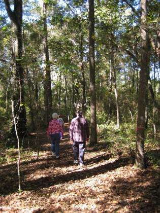
This leads to the second main focus of this essay: the importance of the urban-rural gradient, both for the economy and the ecology, including in both cases, the well-being of the living beings inside and outside the cities.

And finally, we suggest some questions we think are critical and urgent in order to address cities in this wider perspective.

Cities/economy/ecology: an unavoidable, yet uncertain relation

Not disregarding the huge importance of cities in human history and development, and of technology in urban growth, it is hard to understand how sustainability is the result of “high level of urbanization, “wealth-generation engines”, and technology (at least for me, we don’t know about you).

Without technology, no sustainability? If this is the question to answer, I have some more:

What kind of sustainability?

For whom?

What about the small cities that are not “wealth- generation engines”, and cannot afford peak technology? “Are they doomed?

What about the people and their wellbeing, what about the environment?

Fortunately, there are other approaches; approaches that read the figures and facts about cities and, more recently about the whole planet, in this so called “urban age”.

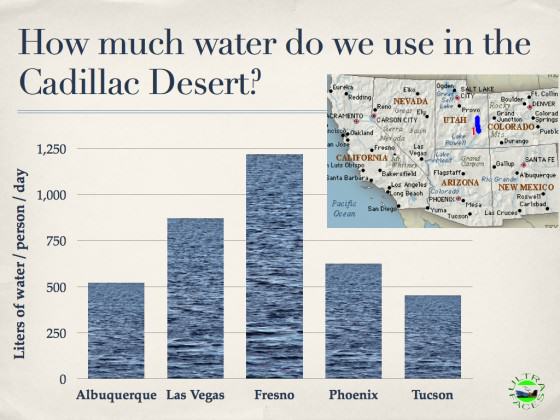
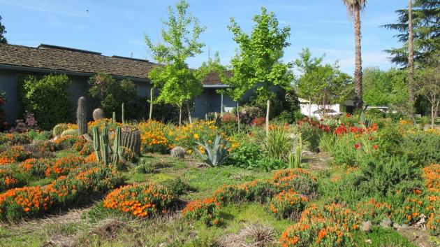
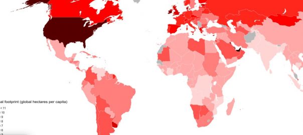
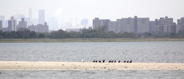
The meeting of mayors on “Cities and biodiversity” (BDC, Curitiba, Brazil, 2007) recognized that, particularly in developing countries, communities depend directly on goods and services from biodiversity (BD). Likewise, it established that the world’s cities occupy 2% of the surface of the planet, but their residents consume 75% of the total resources available. (Would they consume the same if not in the city? I guess not, cities are the “engines of consumption”) This unprecedented pressure on the BD has serious consequences for the supply of ecosystem services, climate dynamics and the well-being of the populations. Plenty of figures and facts.

Table 1
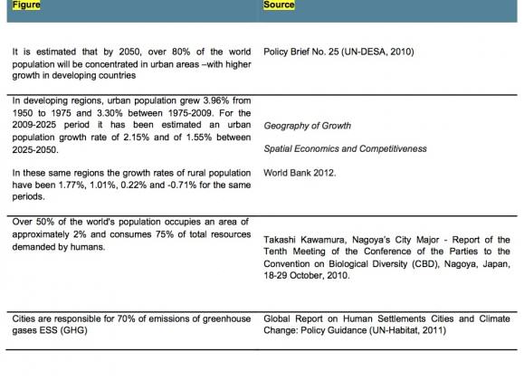
Colombia, an “underdeveloped emerging” country, shares this statistic. It is estimated that by 2020, 80% of Colombia’s population, to be around 48 million at that moment, will live in urban centers, which in our case occupy about 2.5% of the national territory.

According to the statistics, Colombia could be considered an “urban country”, as many have already assured in their political speeches, mainly former city mayors running for president. (What about the other 98% of our country?)

But, are we really an “urban country? What does it really mean that we share statistics with the rest of the world? Probably, that statistics are tricky and can be misleading, if not understood in specific, yet wider, contexts. 

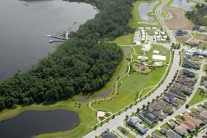
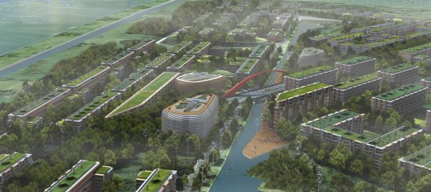
Cities, between green and gray

The current development model encourages the location of higher productivity activities in urban areas all over the world.

In Colombia, the city network contributes 80% of national GDP (DNP 2011). Thus, the political, economic and social attributes of urban areas in terms of access to markets and social mobility expectations have steadily captured the interest of governments, creating a “attractiveness effect” on the inhabitants of the marginalized rural areas. attractiveness with perverse effects on both cities and fields, frequently regarded just as cities hinterland, without identity.

In this context, “environment” and “sustainability” are approached, addressed and managed in different and generally not complementary ways in rural territories (natural area protection and sustainability of agriculture and forestry) and in cities (mitigation of direct impacts on water, air and soil to ensure the quality of viad of “urbanites”). Strong conceptual and political boundaries between “urban areas” and the rest of the territory have disconnected the existing relationships, specially the ecological functionality.

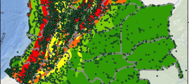
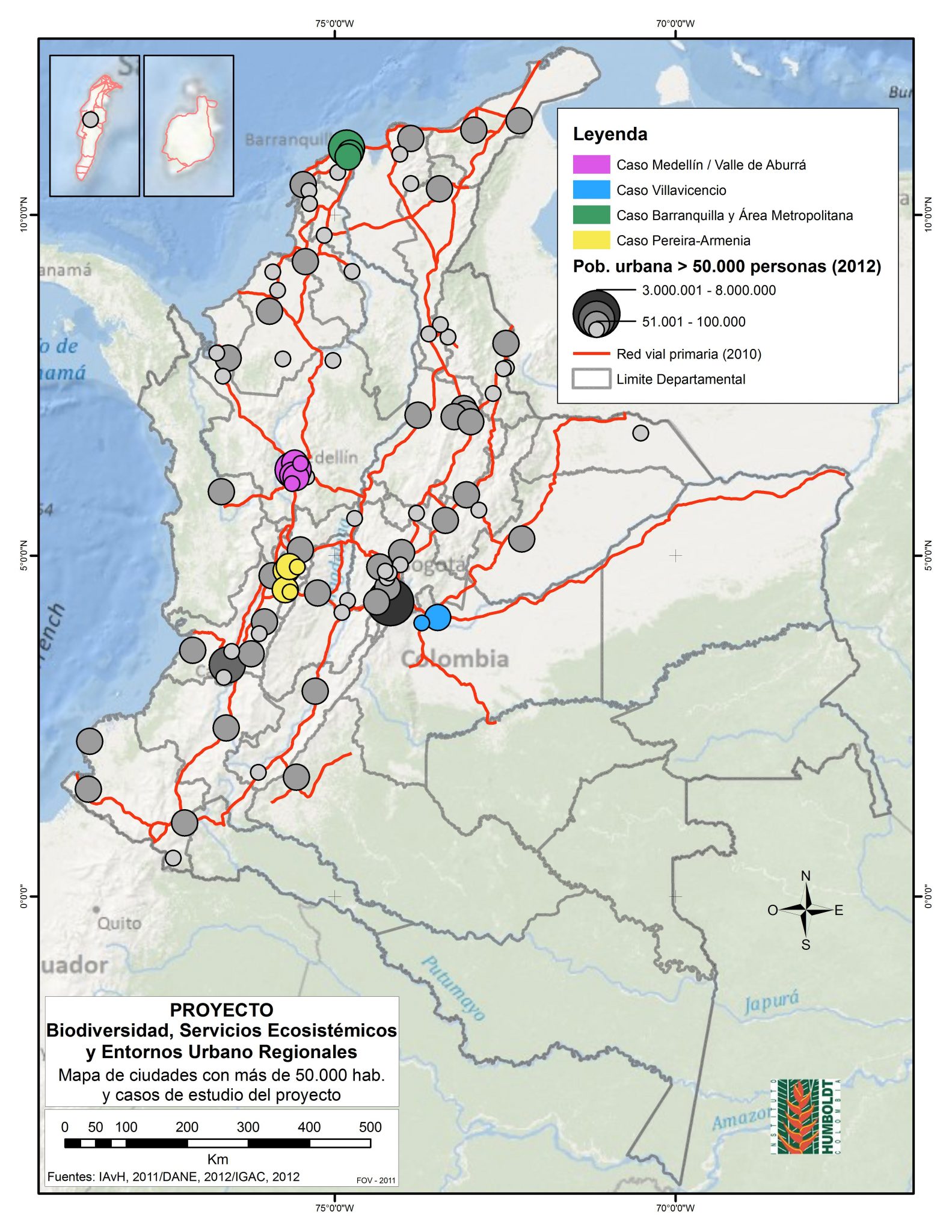
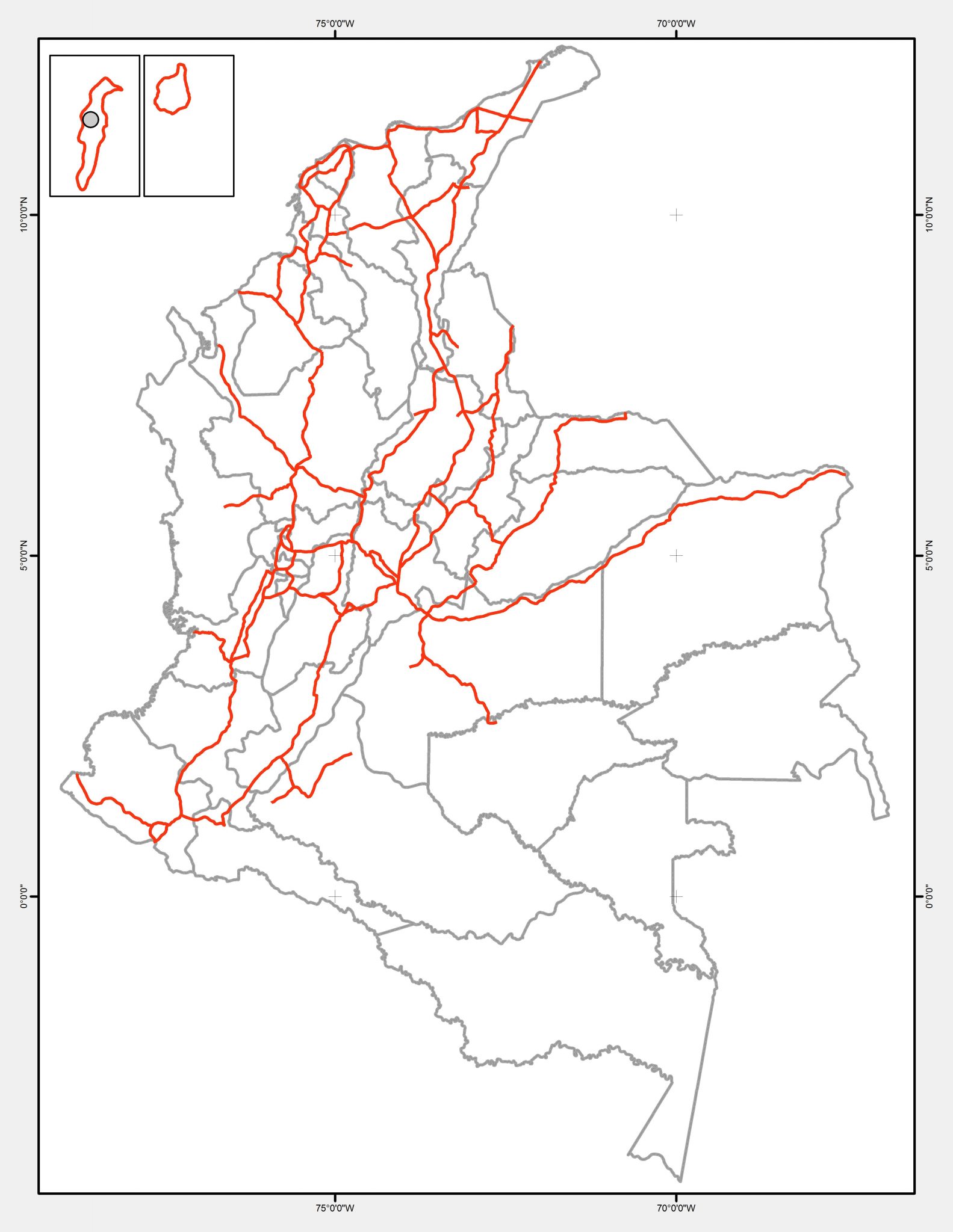
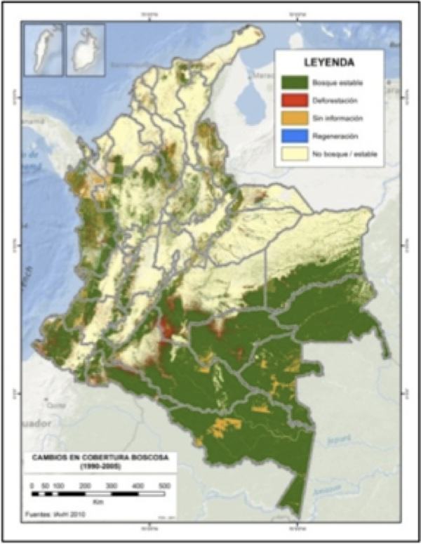
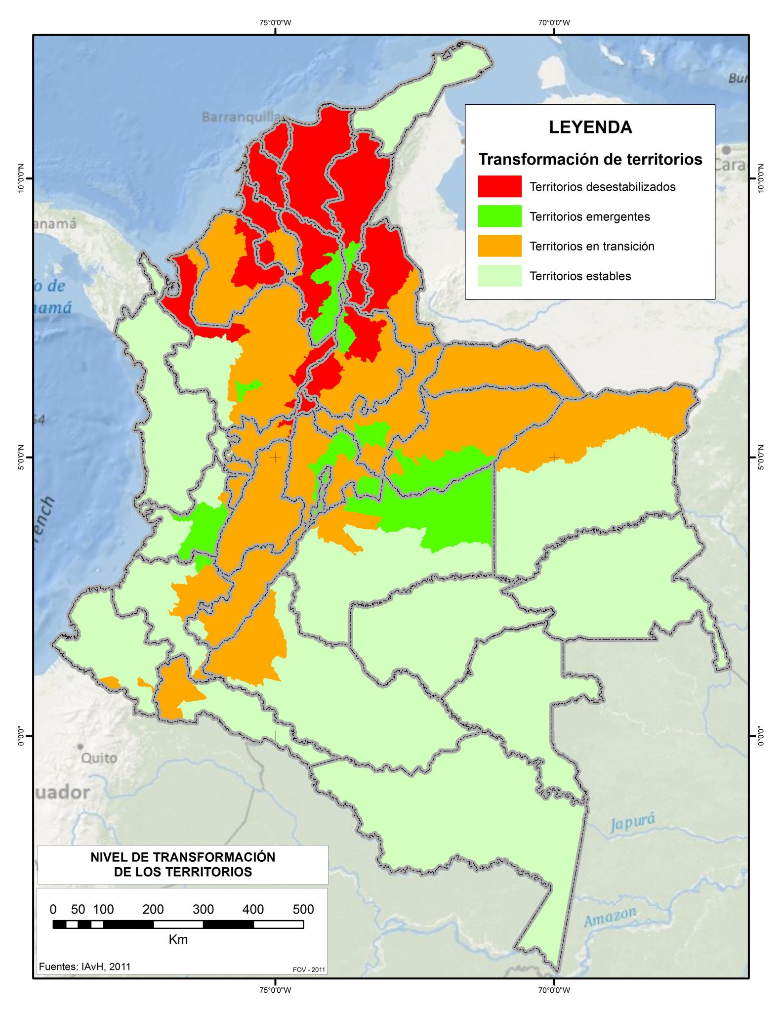
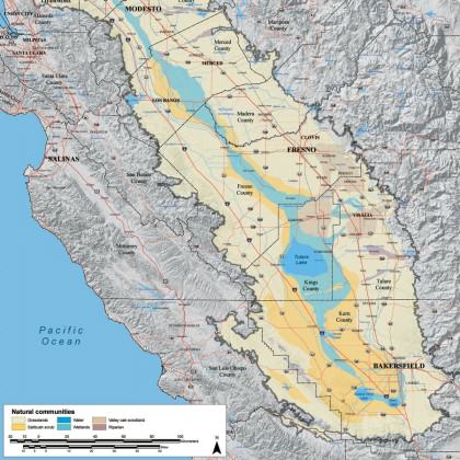
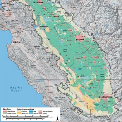
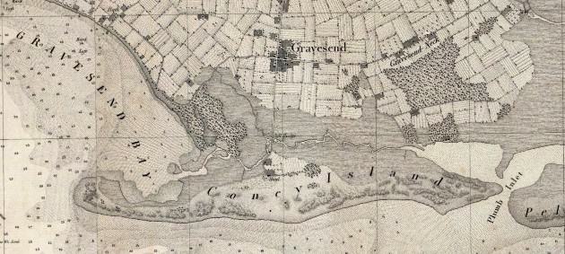
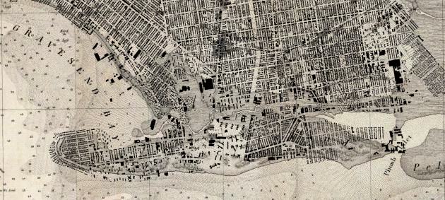
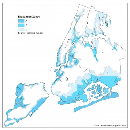
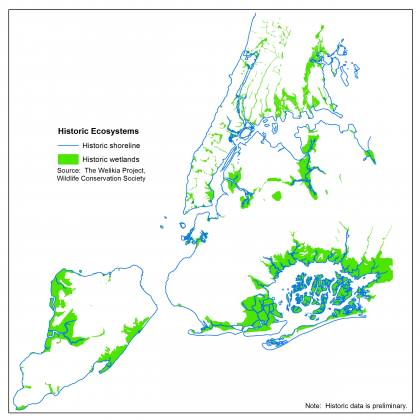
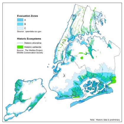
As can be seen in the maps bellow, Colombian system of cities is basically located on the Andean and Caribbean regions. The National Policy diagnosis found that biodiversity loss rates in our country were dramatically evident. National studies have estimated that Caribbean ecosystems have been transformed by 72.4% and Andean ecosystems by 62.1% on average (NPCMBES 67). From 2005 to 2010, the Andean Region presented the highest national deforestation rate at 37% (87.090 Ha/year) followed by the Amazon at 33% (79.797 Ha/year). Thereby ecosystem fragmentation and expansion of the agricultural frontier, two of the main biodiversity loss cau ESS, are mostly due to urbanization expansion phenomena.

Population distribution and main cities. Source: Instituto Humboldt, 2011
Population distribution and main cities.
Source: Instituto Humboldt, 2011

Population concentration and crucial economic development processes (ESS) have taken place mostly in the Caribbean and Andean regions. Since 1950, national urbanization rates have growth exponentially. In 1951, 814 municipalities revealed a 38.9% rate of urbanization; in 2005, 1119 municipalities had a 74.4% rate of urbanization (National Statistics Department—DANE, per its acronym in Spanish).

The territorial changes that most affect the BD and ESS are directly related to urban expansion and its ecological footprint. Increased suburbanization around the cities, continued development of energy infrastructure, and the extension of infrastructure networks for interconnectivity are the main culprits.

Energy network Source: ISA 2009
Primary and Secondary Roads. Source: Instituto Humboldt, 2011
Deforestation rates map (1990-2005). Source: Instituto Humboldt 2011
Mass removal risk and settlements. Source: Instituto Humboldt 2011
Land use conflict (1990-2005). Source: Instituto Humboldt 2011
Ecosystem Transformation. Source: Instituto Humboldt 2011

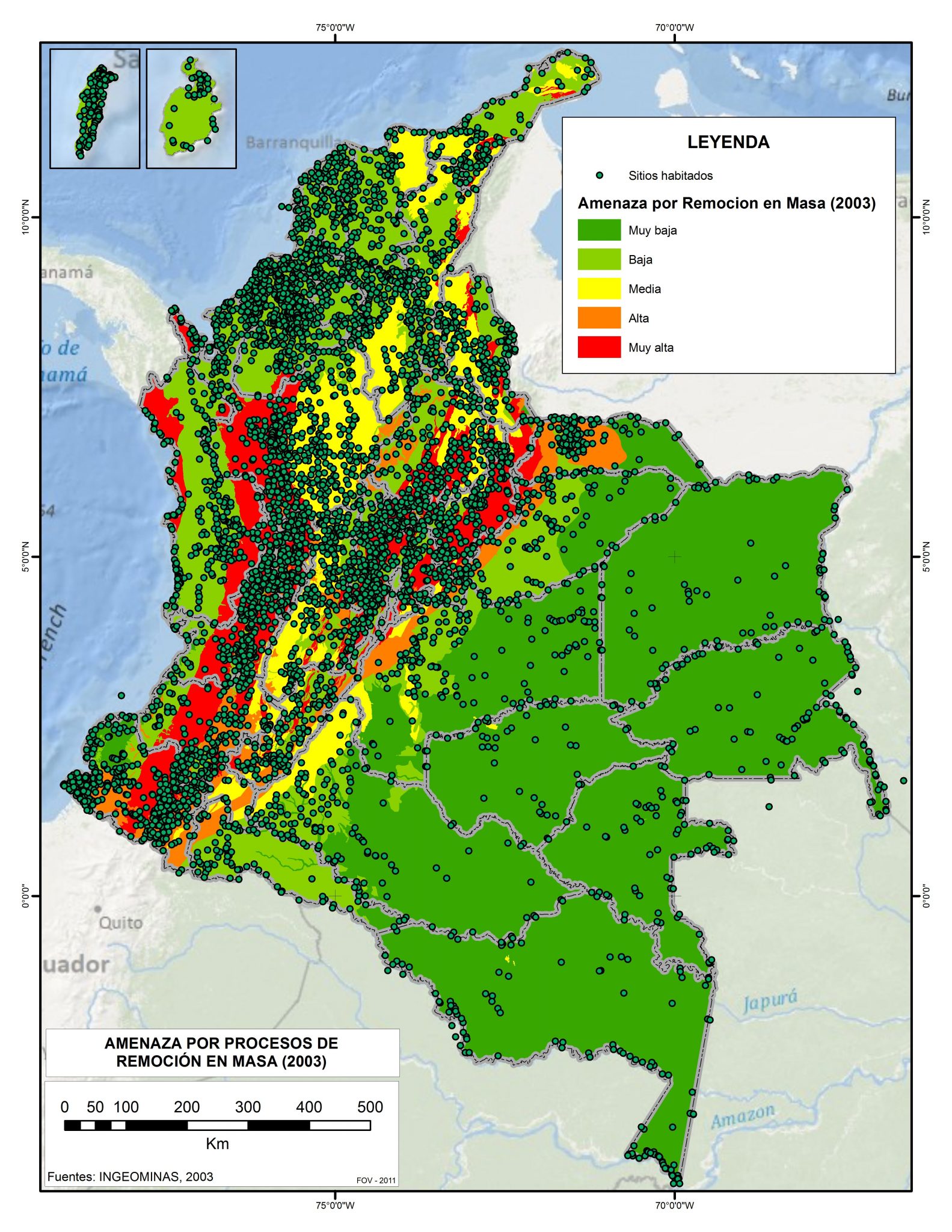
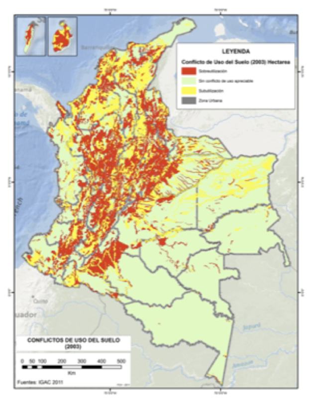
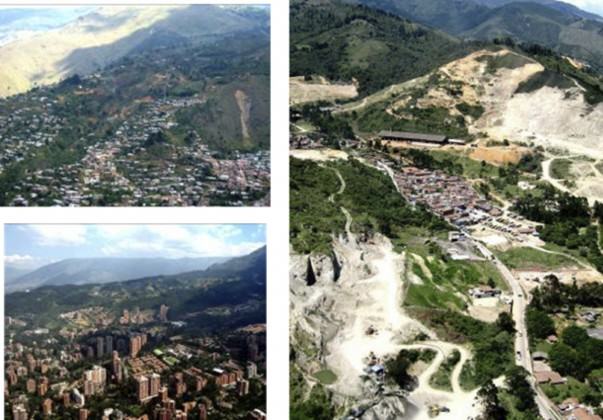
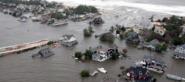
Due to the poor management of the basins and the deforestation of the Andean region, these areas are now more vulnerable. The situation is reflected in the direct relationship between the threat of floods and the threat of landslides. Here, the overlap between the city system maps and the risk maps demonstrate that land use conflict and deforestation make evident that the probability of disaster is higher in Colombian cities and their capacity for resilience is lower.

This fractional approach to social and environmental flows and trades is inequitable, unsustainable and politically obsolete. On the one hand, people who live in areas that support the demands and impacts of urban centers have significantly lower welfare conditions than urban dwellers. On the other, cities struggle to ensure good environmental conditions to a growing population. But, good environmental conditions “inside” the city don´t necessarily mean sustainability of the city. The unresolved stress between cities and not-urban territories has huge impacts in terms of loss and deterioration of BD and ESS, specially in countries like Colombia, where cities are located in rich but fragile ecosystems,

Beyond political and administrative boundaries, the impact of the city is not fully contained in the area that it occupies, but by the area that it needs to satisfy its demands.

The country has made conceptual and institutional efforts to achieve greater environmental quality in cities. However, the level of environmental degradation in the cities, the poorly structured relationship between urban and rural landscapes, and the widespread loss of biodiversity and ecosystem services clearly show that these efforts have not been sufficient and highlight the need to oxygenate the discussion and formulate new and innovative proposals, ones that recognize what is really at stake when talking about “cities and sustainability”.

Rural urban environments? Emerging ecosystems?

The Convention on Biodiversity, the multilateral treaty that tends actions for the conservation and sustainable use of biodiversity and the fair and equitable sharing of benefits arising from their use, defines biodiversity as “the variability among living organisms from all sources including, terrestrial, marine and other aquatic ecosystems and the ecological complexes of which they are part; includes diversity within species, between species and of ecosystems”. As active member of the Convention, Colombia adopted a national policy for integrated management of biodiversity and ecosystem services. It is based on the recognition that “[B]iodiversity constitutes an important attribute of integrated ecological and social systems, in which the relationship between man and nature is manifested not only as the alteration of a natural system (conventional vision of conservation biology), but as a new system with emergent properties of self-organization, in which the constituent variables are no longer just “biophysical” or “social” but the result of interactions between these”.

Both in natural and emerging ecosystems, ecosystem services are the explicit link between biodiversity and human welfare, thus leading to a new and specific definition of sustainability: the ability to generate a steady and adequate supply of biodiversity and ecosystem services required for human welfare.

It is clear, therefore, that biodiversity and ecosystem services must be managed within the interactions between man and nature, this is, in socio-ecosystems.

This is where the debate on the interactions between man and nature is urgent. What new conceptual and methodological approaches are required to manage BD and the ESS in landscapes deeply transformed by land use change, waste management, emissions of greenhouse gases, infrastructure, among others? Cities and their areas of influence become the unit of analysis, “mandatory” for policy formulation that fosters sustainable development. New figures and facts become relevant, as below.

Table 2We must generate and consolidate in the society a new approach to the management of biodiversity and ESS in rural urban environments. This requires not only changing the paradigms of “environmental management” but also of planning, design and urban culture. It requires that we:

(1) rethink the questions from sustainability, uncertainty and dynamism of the (socio) urban-regional ecosystems;

(2) incorporate questions about terms of resilience and adaptability; and

(3) be open in the public policy field and civic culture to new patterns of knowledge and information.

The challenge is not based solely on the current and future demographic pressures. UN-HABITAT has estimated that the population of 46 countries—among which are Germany, Japan and Italy—will decrease by 2050 (Oliveira 2011). The reason for reviewing planning models is that the current models of BD and ESS treat biological, ecological and social systems differently, mainly due to new types of landscapes that don´t conform to the traditional definitions of “urban” and “rural”. Suburban, peri-urban, boundaries, and neo-rural are examples of new names that try to define new (emerging) ecosystems, not yet fully understood and, therefore poorly managed. Trying to consider them as subcategories from urban or rural lanscapes has narrowed the perspective and postponed a needed discussion.

Urban and suburban landscapes in Medellin, Colombia.Source: Medellin Planning Department /2006
Urban and suburban landscapes in Medellin, Colombia. Source: Medellin Planning Department /2006

While the impact of nature on the people of cities is of high significance (ecosystem services or natural disasters, for example), these interactions and flows have been weakly understood and inadequately included in regional urban planning (Forman 2011). On the other hand, the effects of the inhabitants on the nature lack a spatial understanding (or scale) and proper time, and therefore, its management is territorially limited because ecosystems are not recognized as places “open”, in terms of the ecosystem approach implemented by the CBD in 2004.

The urban-rural dialogue must be rebuilt in this new context. This relationship seeks to promote solutions through land planning and environmental governance strategies; local, regional and national agents must be informed about the potential implications of land transformation on biodiversity loss and thus, on human welfare (Andrade, GI; Sandino, JC; Aldana, J. 2011). In this regard, interdisciplinary research (among scientific centers) and science-policy research initiatives are essential to identify policy recommendations of sustainability “in” cities and “of” cities (Grimm et al. 2000; Wu 2008a in Breuste et al. 2011).

Finally, biodiversity and ecosystem services management implies the need to rethink which kind of information and knowledge is “relevant” to guarantee this urban-rural approach and coherence. Is it local, regional, or national?).

The comprehensive management on biodiversity and ecosystem services states considers the roll of scientific and academic information beyond its production and dissemination. Information and knowledge must be aligned to specific decision-making processes under systems of cooperation among stakeholders and across levels: inter-sectorial, interagency and social (CBD 2004). 

Towards the right questions

Without disregarding the important conceptual, empirical and political efforts to address the relationship between biodiversity, ecosystem services and urban dynamics, instrumental developments and theoretical approaches to respond to changes in the socio-ecological urban systems do not yet appear to be evident in relation to decision-making processes and social appropriation interests.

For this purpose, it is necessary to advance in three complementary fields or components:

(1) the integral management of information and knowledge;

(2) policy management, administrative and institutional; and

(3) the management of information and communication.

“Ecosystems” and “cities” are not separate, independent entities, as has been traditionally considered. While the first are object of “conservation strategies” (mainly related to protected and untouchable areas), the second one focuses on “environmental quality” strategies (water, air and sewage treatment, public green areas).

In order to manage cities as ecosystems, first we must recognize that understanding the relationship between BD, ESS and urban-regional environments is essential to generating sustainable conditions. Second, we must recognize that this relationship has diverse manifestations depending on the scale of approach: (i) the network of cities and their impact on BD and the ESS of the country; (ii) the emerging urban-rural regions and their relationships of dependence (ecological footprint); and (iii) the urban area itself and its quality of life.

Taking into consideration the implications of management biodiversity and ecosystem services across urban-regional environments, we would identify the following preliminary questions:

  • To ensure their own persistence and welfare of human populations in specific territories, in a context of drastic change, what decisions should be taken by urban institutions in terms of BD and ESS management?
  • What socio-ecological criteria and priorities for action should guide public policy and its relation to sectorial and land actors in urban-rural landscapes?
  • How do we incorporate uncertainty, adaptability and resilience into planning and ecosystem management strategies among very different and changing territories?
  • What is the capacity for innovation and adaptation of institutions, stakeholders and communities?
  • How much information and knowledge do we already have to answer the above questions and to predict ESS tendencies?
  • How much do we really need to talk, cooperate and act?

These questions are motivating us to apply a multi-scalar approach to urban research initiatives, acknowledging the evident (but mostly forgotten) relationship between sustainability “within” cities and sustainability “of” cities, which we will discuss in future posts.

Juana Mariño Drews
with the collaboration of María Angélica Mejía
Bogotá, Colombia

Temporary Nature’s Potential for Resilience and Liveability

Art, Science, Action: Green Cities Re-imagined

In my last blog I introduced to you the earthquakes that devastated Christchurch city beginning back in September 2010. I had been wondering about what I might share with you in my next blog and when I was driving thru the city the other day and spotted a field of wildflowers on a demolition site it occurred to me! Over 2 years on and more than 50% of the commercial buildings have been demolished in the Central Business District, the re-build is beginning and will accelerate from now onwards for the next 10 to 15 years.  The demolitions have created thousands of tons of rubble and have left vacant spaces everywhere! Lots of room for carparks now……..

Map of central Christchurch,  December 2012. You can see from this photo of the central city below the many open spaces where buildings have been demolished. Note also the Avon River (in green) which snakes thru the middle, a zone of severe liquefaction during the earthquakes. http://www.scoop.co.nz/stories/AK1212/S00080/uc-captures-cbd-aerial-images-for-cera-in-the-rebuild.htm
Map of central Christchurch, December 2012.  You can see from the photo below the central city with the many open spaces where buildings have been demolished. Note also the Avon River (in green) which snakes through the middle, a zone of severe liquefaction during the earthquakes.

It will be clear from the above photo that the centre of Christchurch city now resembles something akin to what we see in many “shrinking” cities in the USA and Europe. With a difference, of course — it is only temporary. But also similar in that there are many, many open spaces (vacant lots). So what I want to tell you about is a real “nature in the city” project that exemplifies both resilience and liveability and what is so great about people, places and nature. Mary Rowe in her latest blog on the Nature of cities site states it very well in my view:

“Increasingly in the imaginative, innovative pockets of city-building there is a recognition that small, seemingly modest local initiatives aggregate up into a whole that makes a city not only more liveable, but are also critical contributors to a city’s resilience.”

GreeningtheRubble
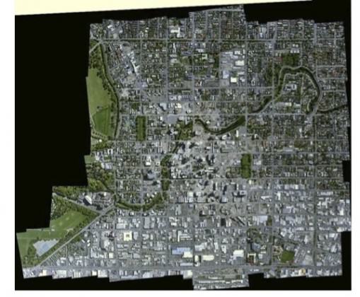
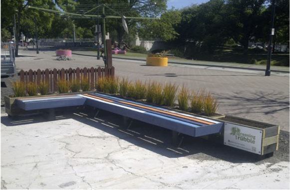
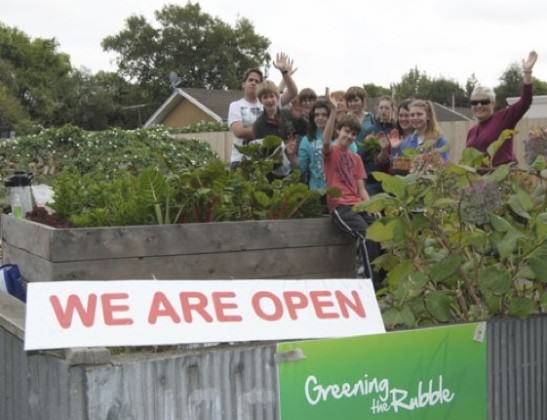
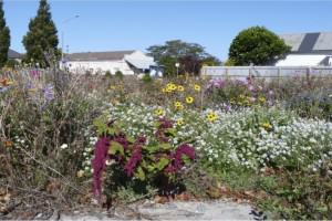
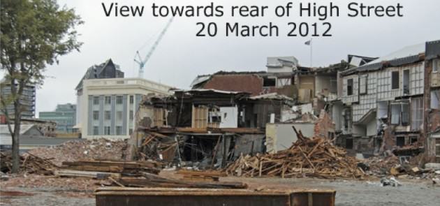
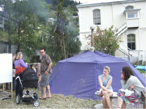
Kiwi’s (people from New Zealand — named after the iconic flightless bird) are renowned for their “will do” attitude of rolling up their shirt sleeves and getting stuck in. This project is no exception. Way back, and in amongst all the destruction and rubble and not long after the first earthquakes happened, a group of volunteers decided to bring nature back, albeit temporarily. “Greening the Rubble” was born and is now an established trust. It is a community project which unites a team of volunteers responding creatively to the extensive damage caused by the earthquakes. The reason Greening the rubble was activated so quickly after the earthquakes was because a number of people were already convinced the city was due for some remedial greening.

Greening the Rubble seeks to bring more biodiversity into the city and it is this urban ecology philosophy that has characterised Greening the Rubble work since its beginning To that extent, it is an experiment in urban ecology that uses private land as an outdoor laboratory. Greening the Rubble volunteers are creating temporary “pocket” parks and gardens on demolition sites, usually in commercial rather than residential streets. License agreements are made with site owners, modest financial support from these owners and extensive sponsorship of the construction materials and design process, make it possible for volunteer teams to build and maintain these parks. These sites are in public use only temporarily, until owners are ready to redevelop — which might be from six months to a few years later. A partner organisation called Gap Filler uses these and similar sites as venues for arts events, performances and installations of usually shorter duration, days or weeks.

The following has been extracted and edited from the Greening the Rubble website. Key contributors to Greening the Rubble include the site owners and:

Examples of Greening the Rubble’s projects

Greening the Rubble’s latest temporary mini-park was in the heart of the suburb Riccarton, at Rotherham Street, surrounded by shops. It included a stage for buskers, seats (which were well used at lunchtime), plants and trees. The mural by Tess, ‘The Hope Bear’, accompanied this garden. The park is due to be dismantled and moved in a few months time. There was a celebration event there on 23 November 2012 with music from Uncle Boyle’s Jazz Triplets, led by pianist Matt Everingham. If you are interested in more, go here.

Tess' mural, the stage and seats in use - the park is finished! http://greeningtherubble.org.nz
Tess’ mural, the stage and seats in use – the park is finished! Greening the Rubble

Relocatable garden (with Dance-O-Mat)

A modular design for planters and seating, built from reclaimed demolition timber, proved versatile in this relocatable garden. Below is a new set which we’ve installed on Oxford Terrace next to Gap Filler’s Dance-O-Mat. A planting of native Libertia pregrinans provides bold orange-green colour.

Modular seats from pallets and planters http://greeningtherubble.org.nz
Modular seats from pallets and planters. Greening the Rubble 

Food garden

At 191 Fitzgerald Ave, Christchurch, a food garden with raised beds has been constructedon the site of two demolished houses. The site owner has longer-term plans for an Arts Centre on this site, but meanwhile seeks productive use of the space, and has put water back on and is happy to allow public access under a license agreement with Greening the Rubble.

Volunteers from Pegasus Health helping at Fitzgerald Ave community garden, Dec 2012 http://greeningtherubble.org.nz
Volunteers from Pegasus Health helping at Fitzgerald Ave community garden, Dec 2012. Greening the Rubble 
Garden now open all hours, with volunteers there each Tuesday morning. Food in exchange for voluntary labour! http://greeningtherubble.org.nz
Garden now open all hours, with volunteers there each Tuesday morning. Food in exchange for voluntary labour! Greening the Rubble
Wildflowers at Worcester Street, Stanmore corner, 2012 Photo: Colin Meurk

Wildflower garden

The wildflowers at the corner of Stanmore and Worcester streets, were initially seeded by a team of volunteers from a nearby town, some 80km south of Christchurch (Ashburton).

St. Asaph ‘lunch area’ beside city offices and car park

In May and June 2011 new surfaces were built using recycled on-site bricks, with added lime-chip and plants rescued from the inner city cordon by CityCare. Three steel planters containing kowhai (Sophora microphylla) trees and flaxes (Phormium tenax, on loan from the City Council) were also placed on site It was completed in July with further re-cycled materials to complete the structures and welded triangular frames for seats. In August recycled timber planks as seat tops were also added. It’s now complete.

What you saw in the Red Zone from the lunch area St.Asaph seats http://greeningtherubble.org.nz
What you saw in the Red Zone from the lunch area St.Asaph seats. Greening the Rubble
The garden at a year old. There's now a builder's shipping container at its rear, which provides some wind shelter. http://greeningtherubble.org.nz
The garden at a year old. There’s now a builder’s shipping container at its rear, which provides some wind shelter. Greening the Rubble

My blog would not be complete without a couple of examples from the Gap Filler team.

July 17, 2011- ?? : Think Differently Book Exchange – Cnr Kilmore & Barabdoes St http://www.gapfiller.org.nz
July 17, 2011- ?? : Think Differently Book Exchange – Cnr Kilmore & Barabdoes St. Gap Filler

Here is an excerpt from the Gap Filler website about this “alternative” idea:

“Imagine you’ve never heard of Gap Filler. You’re walking down Barbadoes Street towards Beat Street Cafe or the Herb Centre. You’re waiting at the Kilmore intersection for the lights to change. You turn around. There’s a big fridge on the vacant site behind you. The lights haven’t changed yet. You look again. It’s not rubbish, the fridge. It’s been placed there quite deliberately. There are even paving stones leading up to it from the footpath. It’s beckoning you. So, you feel a bit silly, but you walk down the path. When you get to the fridge, you see it’s full of books. And not just any books, but great & amazing books that changed people’s lives! This is the Think Differently Book Exchange. A little note inside the fridge invites you to take a book, or come back later and leave one. Open 24 hours a day, 7 days a week, for months…!”

Dino-Sauna comes to town!

A temporary sauna was installed on the old Moda Fotografica site on 28th September 2012 for the weekend (corner Oxford and London Streets). It was tested by a small group of locals on Friday night then it was open for public use on Saturday and Sunday evenings, overseen by the locals an interested onlookers!. Sauna sessions were held for a set duration in the interests of safety.

A temporary sauna. http://www.gapfiller.org.nz
A temporary, ‘pop-up’ sauna. Gap Filler
Built by Fabricio Fernandes, (an architect from Brazil who has, for now, made Christchurch his home) this unique structure had been tried and tested and was ready to be shared with the public. This event was supported by Gap Filler – who else would be crazy enough to try something like this?! http://www.gapfiller.org.nz
Built by Fabricio Fernandes (an architect from Brazil who has, for now, made Christchurch his home), this unique sauna had been tried and tested and was ready to be shared with the public. This event was supported by Gap Filler – who else would be crazy enough to try something like this?!

So there you have it! Creating “temporary” nature that can be shifted around the city from place to place! A prime example of resilience and liveability in an earthquake damaged city!

Glenn Stewart
Christchurch, New Zealand

Urbanophilia and the End of Misanthropy: Cities Are Nature

Art, Science, Action: Green Cities Re-imagined

Jane Jacobs titled her sixth book The Nature of Economies (Random House, 2000). In the Foreword she makes explicit her intent:

“The theme running through this exposition  indeed, the basic premise on which the book is constructed  is that human beings exist wholly within nature as a legitimate part of natural order in every respect. To accept this unity seems to be difficult for ecologists, who assume –– as many do, in understandable anger and despair  that the human species is an interloper in the natural order of things. Neither is this unity easily accepted by economists, industrialists, politicians, and others who assume  as many do, taking understandable pride in human achievements — that reason, knowledge, and determination make it possible for human beings to circumvent and outdo the natural order”. Foreword, The Nature of Economies, Jane Jacobs

Jacobs then proceeds to describe how economic development follows a set of patterns that mimic the patterns of a natural ecology: differentiations emerging from generalities, which in turn produce more differentiations, and the process of co-development. The Nature of Economies followed on the heels of Jacobs’ previous books — beginning with the ever-classic The Death and Life of Great American Cities (1961), through two other economics volumes: The Economy of Cities (1969) and Cities and the Wealth of Nations (1985).

Although her first book (Death and Life…) seems to be the better known in the US, these subsequent ones lay out in provocative detail a way of seeing cities and their economies — and the people who inhabit and participate in them — as a totally integrated part of nature. Her book plays with this double meaning — describing for us the character (nature) of economies while at the same time binding human settlements to nature. I have understood the intent of The Nature of Cities blog to be the same: to provide narratives of how nature resides in the city, but also as a lens into our understanding the composition of the city as natural.

However, the demonization of cities, juxtaposed as it has been against an idealized rural or pastoral landscape, is such a hard meme to break, so often reinforced through popular culture. Television, movies, and literature generally depict the city as the embodiment of crime, trouble, evil, while promoting a sentimental and nostalgic view of small town or rural life. This, then, gets concretized in policy discussions at every level. Density is feared: leading to crime! Over crowding! Higher incidences of HIV transmission! Homelessness! I participated in a meeting last week in Geneva, hosted by several UN agencies and attended by civil society organizations drawn from the global north and south. As part of a larger preparation to review progress towards achieving the UN Millennium Development Goals (which expire in 2015), I found myself in lonely company advocating for the benefits of cities and the promise of urbanization to improve societal outcomes.

How entrenched our belief systems are: that cities need to by fixed, altered, rescued. (Even UN Habitat’s current campaign to link practitioners around the world doing innovative city building, of which MAS, my employer, is an international partner, chose “I am City Changer” reinforcing the notion that cities need changing …).

Once you start watching for it you spot a latent misanthropy in almost every domain. The community development work in North America and Europe over the last six decades has only reinforced this, rallying efforts to “re- store/mediate/vitalize cities”.

To what? Their more ‘natural’ state?

Recreate
Image by Mary Rowe

Fortunately, the life sciences have indeed come to our rescue, over time out-jockeying the mechanistic, linear-ists, persuading us in many aspects of living to look at what is generative, organic, connected to the whole. Jane Jacobs observed city life as inter-connected with the natural and built environments, and her ideas have prompted a contemporary approach to urbanism that integrates uses and users, green architecture and design, local economies (even currencies!), adaptive reuses, and ecological infrastructures. These reflect Jacobs’ recognition that cities — when permitted to — evolve naturally, adding form and function as needed. Jacobs’ method was a simple scientific one: to observe the particular, and extract from it her observations about how cities actually work. She was allergic to ideology, knowing that the complexity of relationships and occurrences in cities most often would produce surprising results that no abstract theory (or its adherents) could predict (or control).

Cities are full of exception, occurrences of serendipity and delight, of innovation and thrift, where someone has tinkered or improvised or been resourceful or imaginative. Good public policy and programs enable the city to make this possible for people. But well intentioned (and some not so) policies inhibit this natural process of city development. Jacobs was notorious in her calling out of large-scale efforts to ‘improve’ the city, seeing them as arbitrary mechanisms to ‘control’ — when in fact what she saw was needed was support for the natural processes that were always occurring in cities, but too often stifled by a number of public and private forces.

Self-organization: the livability of the city

Jacobs observed in the city people’s desire, and capacity if enabled, to self-organize: a concept with which ecologists and technologists are most familiar.

[For an elegantly clear synopsis of Jacob’s ideas on self-organization and how they connect to other natural and manufactured manifestations of it, please read Stephen Johnson’s Emergence: The Connected Lives of Ants, Brains, Cities, and Software (New York: Scribner, 2001).]

Web
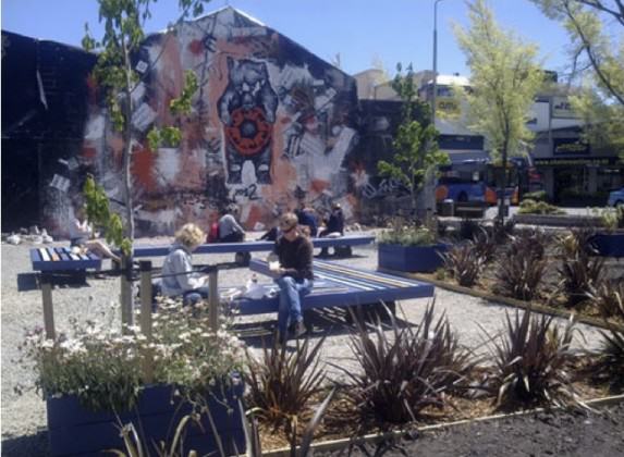
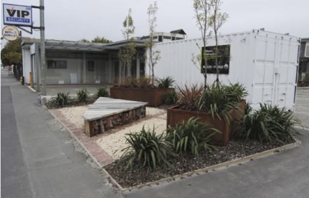
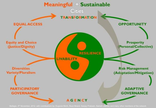
As suggested above, the capacity for self-organization is a critical attribute of city life. If it’s compromised, so is the healthy functioning of the city. Self-organization occurs at every level of city life: within households, city blocks, neighborhoods, districts, the city and region. Walking groups, street vendors, business improvement groups, neighborhood watch initiatives, buying clubs, co-locations for the self-employed, street fairs, affinity groups of all kinds: the desire for city dwellers to make connections with others is what ensures a city is productive and vital: livable. Cities are not an artificial construct (at least the most successful ones aren’t). They are creatures of the living: created by people seeking to organize their lives in ways that sustain and nurture. The dynamism that self-organization delivers, is what we call livability.

Cities in fact are a living unit themselves, ebbing and flowing with the increasingly global tides of commerce and politics, ingenuity and will. Bees make their own hives and ants their own hills, created as part of the larger ecosystems in which they thrive. Surely cities are Homo sapiens’ greatest creation, similarly embedded in a larger web of connection to the assets and resources that surround them.

Systems of connection: an urban ecology

The webs of connection in a city are ‘hard’ and ‘soft’. They enable flows, of people, material, energy, waste. Some formalize, some remain ad-hoc. Every city has these, some are more challenged than others in making these channels of connection work effectively, These systems of capital are what fuel the city. In turn they interweave, or ‘nest’, forming an urban ecology.

[For a full and lively description of the vitality of cities, please see Roberta Brandes Gratz’s The Living City: How America’s Cities Are Being Revitalized by Thinking Small in a Big Way, (New York: John Wiley & Sons, 1994). Gratz is also the co-founder with Stephen Goldsmith of the Center for the Living City, an organization founded on the principles of Jane Jacobs.]

SystemsInACity
Image by Mary Rowe

Increasingly in the imaginative, innovative pockets of city-building there is a recognition that small, seemingly modest local initiatives aggregate up into a whole that makes a city not only more livable, but are also critical contributors to a city’s resilience. These are the two sides of the self-organization coin: a city’s capacity to meet the needs and aspirations of its dwellers (livability) and to productively adapt to diverse challenges and opportunities over time (resilient).

A resilient city has the capacity to swiftly adapt to change and capitalize on opportunity. Although more recently associated principally with climate change adaptation, resilience is a term with resonance across multiple domains (e.g. psychology, biology, engineering sciences, business continuity, community development). Inherent to urban resilience is an integrated, holistic understanding of the connectivity and interdependence of the physical, social, environmental and cultural assets and systems of a city.

The Stockholm-based Resilience Alliance has created this graphic (an instrumental version of my ‘systems of capital’ above) to illustrate these interconnections.

CityDynamics
Image by The Resilience Center.

Any city needs resilience-building strategies that protect it — its neighborhoods, housing, institutions, commercial life, open spaces, cultural assets, and its systems that provide food, transport, health, and protection — from the widest range of risks and challenges.

System-wide investments are crucial, but they need to be underpinned by granular strategies that enable self-organization: where neighborhoods, sectors, institutions are empowered by city dwellers who foster resilience in their homes, workplaces, and places of worship, learning and leisure. Resilience is not a household word (yet), remaining for most an abstract concept confined to engineering schools, scientists, and psychologists.

On the other hand, the concept of urban livability — what a city provides its dwellers to make their lives safe, healthy and meaningful — is a term that resonates with most. Marrying the concepts may be a ‘no-brainer’ to some of us, but certainly decisions that dramatically affect our city life are still most often taken in isolation: public housing is sited where land is cheap but services are costly to deliver (and therefore inadequately delivered); zoning changes incentivize profitable development but crowds out the legion of smaller enterprises that make a neighborhood vital and diverse; public investments in open space, parks, and libraries are cut back, denying the multiple social, economic/environmental benefits these community amenities can potentially deliver to their neighborhoods and the city as a whole.

It may be now that a ‘resilience imperative’, ushered in by more recent severe weather events, will make more urgent the need for public and private investments that boost local resilience, and simultaneously, one would hope, livability.

A livable and resilient city

My city, New York, is arguably one of the world’s most livable ‘global cities’ — absorbing continuous population growth and providing opportunities for immigrants, an international center of knowledge and wealth creation and innovation, a cultural mecca of diversity provided formally through a wide array of institutions and informally on every corner, and with a mix of amenities and attributes that makes for many New Yorkers a daily routine that is productive and enjoyable.

But there are persistent challenges that inhibit this city: areas of concentrated poverty, limited housing choices, land use development pressures that threaten the existing vibrancy of their neighborhoods, and the chronic need for more investment in infrastructures of all kinds, made all the more prescient by the storm events from which we continue to recover. These challenges are common to cities of the size and intensity of New York. The plethora of livability indexes popularized through niche media (Monocle) or global accountancy firms (Mercer) and routinely rank ‘global’ cities like New York, London, Hong Kong and Mumbai very low down the list, providing little guidance or useful measures for improvement for cities as vast and complex as the world’s largest and most productive.

In fact, on-the-ground practitioners connect every day with the physical city: entrepreneurs, activists, designers and planners, artists- and know that city-building is not a zero-sum game. And civil society movements — originating in cities — make clear these win-win opportunities: ‘creative place-making’, ‘localism’, ‘shared streets’, ‘universal design’ are each about mobilizing local assets to generate livability and resilience benefits.

Our largest and most intense cities, whether in the northern or southern hemisphere, are facing increasing challenges placed on them by growing populations, resource demands, aging infrastructures, resource scarcity, and economic downturns or uncertainty. They are also home to remarkable social innovators, designers, entrepreneurs and artists, energized by city life and constantly improvising ways to make life in the city meaningful, just, and productive. These new approaches are most often hyper-local, starting modestly but generating results that could easily be scaled up to have greater impact.

We have much to learn about effective approaches to building city resilience and livability. Whereas New Yorkers may envy the spectacular adaptive reuse examples of London, Hong Kong looks to us for lessons in integrating historic preservation into its land use and economic development strategies. Similarly, what do the informal economies and public markets of Mumbai have to teach other city building practitioners about how cities can foster an entrepreneurial ecosystem? And what about the network of social innovation entrepreneurs tackling urban design challenges in Bandung and Rio?

Beginning in 2011 the organization for which I work, the Municipal Art Society of New York (MAS) — a century-old advocacy organization concerned with the relationship between the city’s built form assets and its people — began reaching out to urban innovators: artists, designers, planners, teachers, and entrepreneurs living in other global cities to share approaches, and discuss disruptive innovations that are making their cities more livable and resilient. This initiative is based on a theory of change that urban innovation is fostered locally and then scaled up, and continuously adapted to changing conditions, with the support of enabling public policy and investment.

Our most effective instruments of livability and resilience scale in both directions: for instance, community gardens and naturalized spaces could hold storm water, grow and distribute food, show art, mitigate urban heat island effect, host Tai Chi and/or a FEMA trailer, dispense flu shots, provide local respite places, show movies, offer wi-fi hot spots or charging stations, display locally created maps or evacuation instructions from the City, provide a pop up space for the branch library These approaches contribute to the livability and resilience of the city.

Connecting cities with cities: growing the urban ecology 

The world’s global cities make possible the peer-to-peer trading that fuels the global economy, which is fundamentally urban, facilitating connection between entrepreneurs, researchers, investors and consumers. Nowhere is social media more robust than in the global cities of the world, and speaks to the appetite of urbanists to learn from each other. Aggregating those examples necessitates creating platforms to connect and nurture the global urban resilience ecosystem of practitioners.

Similarly, a network creates a platform for the exchange of practices to improve the livability and resilience outcomes of their cities, and in the aggregate, over half of the world’s population who live in the global city. It provides a unique learning and advocacy platform for the best in city-building practice, across sectors and disciplines, to spread the social innovations that potentially affect hundreds of millions of lives, and the natural ecosystems that support them. The value proposition of this initiative is that it is grounded in the practical: with an explicit commitment to link, across sectors and disciplines, with practitioners actively contributing to outcomes at the most local level.

An initial meeting of this Global Network was convened by the Municipal Art Society of New York and supported by the Rockefeller Foundation, with founding participants who are engaged in resilience and livability initiatives from two dozen cities around the world. The common finding from this group was the need to develop a ‘new paradigm’ that embraced the physical and aspirational nature of cities — see the draft paradigm below — and was relevant to cities in both the northern and southern hemispheres. What has emerged is a pattern of understanding the city as a living system, providing its citizens with opportunities and access, prosperity and dignity, protection and choice, and systems of engagement and governance that maximize livability and resilience. With a common framework, this initiative is now cross-pollinating innovations between city builders, strengthening the connective tissue within cities and between them.

Our next step is to create a digital learning platform, where we can, as Jacobsean urbanists, observe in our own cities and others, how livability and resilience are being ‘home grown’ and connected up, to strengthen the ecosystem in which the nature of cities, of the world, resides.

Mary Rowe
New York City

The Livability+Resilience paradigm, created at the MAS-sponsored Bellagio conference.
The Livability+Resilience paradigm, created at the MAS-initiated and Rockefeller Foundation-supported Bellagio conference

Musings on Winter’s Darkness and the Ways that Birds Brighten Urban Lives

Art, Science, Action: Green Cities Re-imagined

My enchantment began on a Saturday morning, shortly before solstice and not long after I’d moved from Anchorage’s lowlands to the city’s Hillside area. Lolling in bed, I glanced outside. And there, before me, were several black-capped chickadees flitting about a backyard spruce. Wonderful, I thought. Here’s a chance to meet some of my new neighbors. Inspired by their presence, I put a bird-feeder on the middle deck, where it could be easily observed from the living and dining rooms. My first-ever feeder wasn’t much to look at: an old, slightly bent baking pan. Still, it held plenty of seeds and sat nicely on the railing. Nothing happened that first day. But Sunday the birds returned. Seated at the dining room table, I watched a tiny, fluffy, winged creature land on the pan.

Clack-capped chickadee. Photo: Wayne Hall
Black-capped chickadee. Photo: Wayne Hall

The chickadee grabbed a seed and zoomed off to a nearby tree. Then in flashed another. And a third. For each the routine was similar: dart in, look around, peck at the tray, grab a seed, look around some more, and dart back out. Nervous little creatures, full of bright energy, they somehow penetrated the toughened shell of this former sports reporter and touched my heart. I laughed at their antics and felt an all-too-rare childlike fascination.

Common redpoll on a feeder. Photo: Wayne Hall
Red breasted nuthatch. Photo: Wayne Hall

Within days, the chickadees were joined by several other species, most of which I’d never seen (or noticed) before: red-breasted nuthatch, common redpoll, pine siskin, pine grosbeak, downy woodpecker. And what started as mere curiosity bloomed into a consuming passion. I found myself roaming bookstores in search of birding guidebooks, spontaneously exchanging bird descriptions with a stranger, and purchasing fifty-pound bags of seeds.

All of this seemed very strange to a forty-four-year-old who had never been intrigued by birds (except for charismatic raptors) and previously judged bird watchers to be rather odd sorts. I didn’t know what it meant, except that a door had opened.

And I passed through…

I recount this encounter from the early 1990s because it became a turning point in my life. In the years since, birds have enriched my life in unexpected ways, including—and perhaps especially—they add cheer to my days during Alaska’s longest and harshest season.

Waxwings on mountain ash. Photo: Wayne Hall
Waxwing on a snowy mountain ash. Photo: Wayne Hall

Winters in America’s far north can be hard on a person, even one living in the city, along the relatively mild coast of Southcentral Alaska. Here in Anchorage, it’s not the cold that’s a problem (in January, our coldest month, the average high and low are 22° and 8° Fahrenheit, respectively), nor the snowfall (mid-winter rains are more depressing than a foot or two of snow). The biggest problem, it seems, is darkness. And one of the best solutions, as I’ll describe below, seems to be getting outdoors and paying attention to the brightening presence of birds and their voices.

Long hours of darkness wear on many Alaskans, even in Anchorage, which on the winter solstice receives slightly less than 5½ hours of daylight. And from late November to late January, nine weeks in all, we get less than seven daylight hours. (By the time this is posted in late February, we’ll be relishing nearly ten hours of daylight, with hints of the longer and brighter days at the end of winter’s long, dark tunnel, the spring equinox now less than a month away.)

Making matters worse are the abundance of heavily overcast days, which in my journals I frequently describe as “dreary.”

Waxwing on an ash. Photo: Wayne Hall
Waxwing eating a mountain ash berry. Photo: Wayne Hall
Mountain ash berries, a favorite waxwing food. Photo: Wayne Hall
Boreal chickadee at a feeder. Photo: Wayne Hall

I simply cannot imagine living in the arctic, with daily light measured in minutes or not at all, for weeks or even months at a time. I’m amazed that people can survive, let alone thrive, along Alaska’s northern coast, where, for instance, the community of Barrow goes more than two months without seeing the sun (Nov. 20 through Jan. 23).

Based on my own experience and conversations with many friends and acquaintances, I feel safe in saying that winter’s darkness tends to take a cumulative toll, at least for those of us who grew up in more southerly locales and moved to Alaska as adults. After 15, 20, or 25 years of northern life, extended darkness weighs heavier on people, especially those who can’t easily get outdoors during the season’s short days. Or maybe it’s simply part of the aging process; one study conducted in Fairbanks concluded that seasonal affective disorder, or SAD, was more prevalent among people older than 40.

Looking back, it seems I somehow intuitively recognized my personal need for substantial daily winter doses of sunshine soon after moving from Southern California to Anchorage in February 1982, even if thick layers of clouds dimmed that natural light. Though I kept the long and sometimes crazy hours of a sports writer my first years in Alaska, I made it a point, whenever possible, to get outside during the day’s brighter hours, preferably for an hour or more.

Scheduling outdoor time became easier in the early 1990s, after I’d chosen the life of a freelance nature writer. It became part of my self-imposed job description to spend time “out in nature,” whatever the season or weather.

Not coincidentally, perhaps, it was also about this time that I discovered songbirds—in the darkest depths of winter, no less. That personal discovery, and my newfound passion for birds, was (as I note above) in turn tied to a move to Anchorage’s Hillside area (I’ve described that relocation in Living with Wildness: An Alaskan Odyssey and also my first TNOC posting, “Rediscovering Wildness—and Finding the ‘Wild Man’—in Alaska’s Urban Center”.

Following my life-changing introduction to the neighborhood chickadees, birds became another reason for me to more closely explore Anchorage’s landscape, throughout the year. And because not many birds stick around during winter—at least in large numbers—I quickly learned the more common resident species.

Anchorage’s Christmas Bird Count (CBC) participants have recorded as many as 52 species, but less than a dozen are likely to be regularly observed at feeders or along the city’s trails. And while a handful of raptors and a few water birds inhabit the city in winter, my favorites remain songbirds, especially the ones drawn into feeders, which I’ve been able to study and admire up close.

Mountain ash in autumn colors. Photo: Wayne Hall

Both at home, as a feeder watcher, and on my walks (and occasional skis), it soon became part of my routine to look for, and listen to, my avian neighbors. And this became another way, an important way, that I could endure—or, better yet, embrace and occasionally delight in—Anchorage’s six- to seven-month-long winter season.

Besides the common feeder birds, a few other passerine species have brought me special delight: brown creepers, which often hang out with chickadees and nuthatches but rarely, in my experience, visit feeders; American dippers, impressive in their frigid, depth-of-winter swims; ravens, which in their raucous way enliven the city, many of them visiting during the daylight hours to hunt food and play, then head for the hills to roost for the night; and bohemian waxwings, which don’t stay the entire winter but help to brighten the city during winter’s darkest days.

The presence of waxwings seems especially worth mentioning here, not only because they bring such pleasure and amazement to many of us human residents of Anchorage, but because their temporary occupation of the city in enormous numbers is a relatively recent phenomenon that’s directly tied to an increase of other, introduced species. This local connection is another example of the issues that Matt Palmer explored in his TNOC posting, “Our Changing Urban Nature: Time to Embrace Exotic Species? (Or at Least Some of Them)”.

Bohemian waxwings are rarely, if ever, seen in Anchorage’s highly developed downtown and midtown areas from spring through fall. But in early winter—usually sometime in mid- to late October—they begin to appear, initially in small and easy to overlook numbers. But by year’s end, thousands of them inhabit the city.

It’s remarkable, really, that birds which normally avoid Alaska’s urban center suddenly invade it in such huge numbers. What draws them here (as you might expect) is food. In recent decades, locals have planted hundreds, perhaps thousands, of fruit-bearing trees in yards and along Anchorage’s streets. Over time, waxwings learned that when food becomes scarce in their normal habitats—the forested lands beyond Anchorage—there is still plenty to eat in the city. Singly, in pairs, and small groups, these wide-ranging “gypsy birds” head into town for an amazing feast.

Roaming the city, they swoop and dive in synchronized flight while they move from neighborhood to neighborhood and street to street, descending on yards and greenbelts to strip ornamental trees of their fruit: mountain ash berries, chokecherries, crab apples.

As the days and weeks pass, small groups coalesce into ever-larger flocks, until by December multitudes of the birds swirl through the sky. A few years ago, participants in Anchorage’s CBC tallied more than 22,000 waxwings. One serious birder told me he’s seen as many as 3,000 in a single flock and knew of others who’ve watched 5,000 or more in flight.

Once the food is gone, the birds depart. Most years, Anchorage is again largely waxwing free by late January or early February.

Chokeberry blossoms. Photo: Wayne Hall

At least one group of the fruiting trees that pull in waxwings, all commonly called chokecherries, has proved itself a troublesome invasive. The European bird cherry or Mayday tree has especially become a problem. Local foresting experts say this chokecherry is displacing native vegetation, pushing out understory plants like Canadian dogwood, willow, and alder. In 2011, municipal forester Scott Stringer told local TV station KTUU that the Mayday tree “has taken over the entire creek corridor along Chester Creek,” one of the main streams that pass through Anchorage.

Besides displacing indigenous plants, chokecherry trees have killed moose. As reported in the Anchorage Daily News in February 2011, a state wildlife veterinarian determined that three moose calves had died from cyanide poisoning after eating the frozen buds, branches, and berries of Mayday trees. It’s likely that some portion of other winter-kill moose have similarly been poisoned over the years, but the attention given to those particular calves’ deaths, plus the increased and substantial evidence that chokecherries are supplanting native species, has led to an effort to control them. Besides agency efforts, the public has been recruited. During the summer of 2011, for example, more than 100 volunteers participated in a  “weed smackdown” to remove chokecherries from Anchorage’s Valley of the Moon Park (the event reported by KTUU).

Given the chokecherries’ popularity with both waxwings and humans (in early summer the trees have beautiful, fragrant white flowers and they ornament many yards around the city), it’s likely the chokecherry is here to stay. But forestry experts hope that continued removal programs—including occasional smackdowns—and efforts to get nurseries and homeowners to stop planting new trees will limit the invasives’ spread.

However much chokecherries are cut back, there are enough other fruiting trees spread around town to keep waxwings returning to our city.

There’s one way, in particular, that Anchorage’s winter birds brighten my days: with their voices.

Even when I can’t see my avian neighbors, as sometimes when walking through the woods, I can usually hear them. In fact their voices are often what alert me to their presence. Every day when I step outside my house, whether it’s to retrieve the newspaper or mail, to shovel snow, or go walking, I listen for birds. Whether it’s the chatter of black-capped and boreal chickadees, the nasally yank, yank, yank of nuthatches, the chirping of redpolls, the warbled songs of grosbeaks, the cawing of ravens, or the soft trills of waxwings, their voices add some measure of brightness to my day and this is no small thing.

There are times when I’ll hear the faint voice of a chickadee or redpoll or waxwing, and stop to see if I can find the bird. And in my stopping I’ll begin to see several of them, occasionally (with redpolls and waxwings) even dozens, that I hadn’t noticed only moments before, perhaps because I was lost in my own thoughts or worries or plans. And I’m reminded how even in the city we’re surrounded by wild creatures and other forms of life, which we so often ignore or take for granted.

Bird song is more likely to get our attention in spring and summer, when dozens of species mark the nesting season with their loud and often lovely voices. But though less abundant and less diverse in winter, the songs and chatter remain important to me and, I’m sure, to others who pay attention. I was reminded of this while reading Tim Beatley’s TNOC posting, “Celebrating the Natural Soundscapes in Winter,” which inspired me to write a commentary for a local online news journal, the Alaska Dispatch, “The noise and the fury: Snowmachines in Kincaid Park?”.

Our cities have plenty of obnoxious noise. But they also have their share of pleasing, relaxing, and delightful sounds too, most of them, in my experience, provided by nature.

Here I’ll return one more time to the waxwings and their brightening influence.

Bohemian waxwing. Photo: Wayne Hall

The presence of breathtakingly huge flocks, and their sudden descent upon neighborhoods, is only one of several great delights that bohemian waxwings bring to Anchorage residents. They are among the handsomest birds to inhabit the far north, their bodies mostly covered by a gray suit of silky feathers, tinted russet about the head. Their feathered finery is further decorated by a tail brightly edged in yellow, a black eye mask, and white-striped wings that bear the small red “wax” bars that give the birds their name.

Beyond that, waxwings sing and talk among themselves in soft, reedy trills that are pleasing to the human ear. When a flock visits the neighborhood, I often stand silently a while, simply to enjoy the music in their voices.

It is an amazing and unforgettable thing, to stand among hundreds, perhaps thousands, of birds as they swirl through one’s own neighborhood, trilling softly yet brightly. To be surrounded by such abundant, spirited life is an absolute treat, a flash of brilliance and hopefulness during the north’s longest, harshest season. No wonder, then, that the waxwings’ short but intense presence here—and my increased awareness of them—has become one of my great pleasures, and comforts, during Alaska’s long winters.

Bill Sherwonit
Anchorage, Alaska, USA

In Terms of Conserving Biodiversity—How Functional is a Conservation Development?

Art, Science, Action: Green Cities Re-imagined

I recently blogged about how we could construct urban communities that conserve biodiversity. On private lands marked for development, one strategy to conserve biodiversity is to build a conservation development (CD). CD is an approach to the design, construction, and stewardship of a development that achieves functional protection of natural resources, while also providing social and economic benefits to human communities. Projects range from low-density limited development projects in rural areas to higher density subdivision developments in suburban and urban areas. Conservation developments commonly aim to maximize the conservation of natural areas and biodiversity in conjunction with clustering housing on a portion of the site. It is a popular approach to conserve natural resources on private lands.

But how functional are they?

Conserved forested areas next to a lake in a conservation development – Harmony, FL.  Courtesy of Harmony Development Company.
Conserved forested areas next to a lake in a conservation development – Harmony, Florida (USA). Courtesy of Harmony Development Company.

Whether you are buying a new home, designing a conservation development, or evaluating a proposed conservation development as a city/county regulator, what issues should you be aware of that impact the long-term functionality of a neighborhood? Is the design and management of the development going to conserve natural resources over the long term? What to look for? What key questions to ask?

To help evaluate the potential “functionality” of a conservation development in both the short- and long-term, I post below four key questions to consider. Use them to start a conversation about the conservation design and management of a proposed conservation development. The questions below address home, yard, and neighborhood issues.

Question #1: What kinds of tree protection and natural area conservation strategies have been employed?

When driving through a conservation development—either before or after the homes are built—you may see lots of vegetation: designated natural areas (meadows, wetlands, and forested areas) and large trees left on individual lots. However, the way trees and whole natural areas were designated and managed during the construction process is critical for their long-term health.

For trees, it is vitally important that their root systems be protected from damage during the construction process. Tree roots absorb oxygen, water, and nutrients for survival. Find out if fencing was used to prevent heavy vehicles, from damaging trunks and running over the root zone causing soil compaction. Compaction smothers roots and prevents them from absorbing essential nutrients. Ask or see for yourself how much of the area around the tree was protected. It’s not enough just to place a fence or flagging around the trunk of the tree. The roots underneath the drip line (the outer edge of the leafy canopy) should be protected by a sturdy fence. You may wind up dealing with the expensive problem of cutting down a dying tree near your house, a tree that was actually killed during construction. It just took several years to see the full effect bad practices had on it.

Pileated woodpeckers foraging on a tree. Woodpeckers use trees for both foraging and nesting.  Courtesy of UF/IFAS, Thomas Wright.
Pileated woodpeckers foraging on a tree. Woodpeckers use trees for both foraging and nesting. Courtesy of UF/IFAS, Thomas Wright.

The single best factor that will help ensure the survival of a protected tree is irrigation. Stressed trees need plenty of water during the construction process and this means watering each tree to a soil depth of 30 cm about 2–3 times per week, depending on local site conditions.

With regards to designated natural areas, what kinds of management strategies have been implemented, both during the construction phase and post-construction? At a minimum—as required by law in most U.S. states — there should be well-maintained silt fences around any wetlands or water bodies to prevent silt from entering these areas during construction. Run-off can carry vast amounts of silt and other pollutants into a wetland and essentially choke this system to death. Well-maintained is the operative word here. Check around the construction site. Are silt fences properly placed? Have any fallen down?

Wetlands and small ponds without buffers, where lawn is right up to their margins, can cause a decline in water quality. Usually lawns are managed with fertilizers, pesticides, and herbicides, and without a buffer between the lawn and the water body, these chemicals can drain right into the water.

Take a close look at the “natural” areas. Do they look natural? The protected areas may be heavily infested with invasive exotics, such as Chinese Tallow trees, and may even be dominated by exotic/ornamental vegetation such as old fruit trees. A conscientious developer could implement some kind of restoration plan to remove exotic vegetation, with a long-term strategy to prevent re-invasion.

In more natural remnants, trails meant to be used by residents should be placed in areas to minimize disturbance of wildlife; for example, along the edges of natural areas and not crisscrossing through the middle.

Residents enjoying a stroll through a wooded remnant in a development. Staying on trails is an important action by residents to minimize impacts on local plant and animal communities.  Photo by Mark Hostetler.
Residents enjoying a stroll through a wooded remnant in a development. Staying on trails is an important action by residents to minimize impacts on local plant and animal communities. Photo by Mark Hostetler.

A subdivision with protected natural areas must have a management/educational program for the entire community that addresses the boundaries between natural and human-dominated areas. The health of these natural areas is intricately tied to the behaviors of nearby residents. For instance, residents should not take all-terrain vehicles (ATVs) into natural areas as this would disturb local plants and animals. In a conservation development, developers need to install some sort of visible educational program that addresses how local neighborhood actions affect natural areas (see question 2, below). In particular, is there a funding mechanism in place to implement and maintain the management/educational program?

For example, the control of invasive exotic plants, prescribed burns (where required), and other management practices take money to implement. Even the upkeep of an educational program (signs, web site, etc.) takes money to keep it going. Funds can come from a portion of lot sales, homeowner association dues, and from a portion of density bonuses a developer may have received by doing a conservation development.

To promote native plant regeneration, a prescribed fire burns near the Prairie Crossing conservation development, Illinois. Photo by Mike Sands

Question #2: Is there a long-term environmental education program for residents in the conservation development?

Homeowner understanding and buy-in are essential if the community is to function as originally intended. Although it is the developer who originally built the conservation development, it is up to the community residents to manage and maintain the conservation design in the built and conserved areas.

A tour group stops to read an educational sign about conservation practices implemented in the Town of Harmony, Florida. Photo by Mark Hostetler.

As an example, consider the effect if a homeowner added new plants to her/his garden and her/his choice included some invasive exotics. That choice would have an impact on nearby natural areas. The invasive plants could spread into those natural areas and have a negative impact on wildlife and native plants. Property owners need to know which plants are considered invasive exotics and avoid planting them in their yards. They also need to know how to remove any invasives that might currently occur in their yards.

Initial design is fine, but management is key! Neighborhoods turn over: houses are sold all the time, experienced owners leave, and new owners arrive, unfamiliar with the goals of a conservation development. All residents must be on board in terms of understanding the goals of conservation development and actions that help conserve natural resources.

One way to get the word out is for the developer to set up an educational package that consists of a website and kiosks. The elements help inform residents in the following way:

  • Interpretive Kiosks: Highly visible interpretive kiosks/signs are placed in public areas where people traffic is high (such as sidewalks) or on a trail system in conserved areas. Each of the signs contains informative displays that discuss a particular topic, such as water, energy, or wildlife. Kiosks should be dynamic, with different informative panels being inserted throughout the year.
  • Web site: Because the kiosks/signs can give only limited information, an associated Web site is constructed that gives detailed environmental information and management strategies pertinent to a community.
A sign along a sidewalk in the Town of Harmony, FL that describes the benefits of prescribed fire to residents; this sign was necessary in order to inform residents and promote acceptance of prescribed burns near the community. Photo by Mark Hostetler
A sign along a sidewalk in the Town of Harmony, Florida (USA) that describes the benefits of prescribed fire to residents; this sign was necessary in order to inform residents and promote acceptance of prescribed burns near the community. Photo by Mark Hostetler

For an example of a community that has both an environmental education package and website, visit here.

Question #3: Do the Covenants, Codes, and Restrictions (CC&Rs) address any environmental issues?

Most master planned communities in the USA have Covenants, Codes, and Restrictions (CC&Rs) which act as guidelines to how the community is managed. These help set the flavor and tone of the neighborhood and the CCRs are sometimes attached to the deed of the house. If the community has a homeowner association (HOA), it usually has the power to enforce the CC&Rs. Thus it behooves a homebuyer to understand what the CC&Rs regulate—especially if they don’t encourage sustainable practices.

There are several things to look out for: first and foremost, is there language within the document that could prohibit sustainable practices? For example, the CC&R document could stipulate that the front yard has to consist of 80% lawn. If you (as the homeowner) decide to convert the lawn to more native landscaping, you would not be able to do so without penalty.

On the other hand, if the CC&R document contains information about conservation design and management practices, it can promote good environmental stewardship and conservation of wildlife habitat. Some examples of this include:

    • prohibitions against planting invasive exotic plants (and definitions of what “invasive exotic” means)
    • recommendations about pet care and wildlife (e.g., rules against free-roaming pets)
    • no rules against keeping dead trees (i.e., snags) in place; these are beneficial to woodpeckers and other wildlife species
    • requirements to landscape with native plants and a list of native plants

Take a close look at the wording and intent of the document; it should state somewhere that one goal of the conservation development is to conserve natural resources. See University of Florida’s EDIS document for an example of a CCR that addresses some environmental issues for a town in Florida. Also see this example of greening your CC&Rs from the Idaho chapter of the U.S. Green Building Council.

Question #4: What types of plants are used for landscaping within the conservation development?

The plant palette is the selection of plants that a landscape architect (hired by the developer) installs around homes and in shared spaces such as medians and parks. If the developer provides you with a list of plants, the first question to ask is “Which of these plants are native to the area?” Using native plants—naturally adapted to local climate and soil conditions—saves water and energy. Typically, native plants (once established) do not require the water, fertilizers, pesticides, and herbicides that some non-native species need. When these chemicals are applied to yards, they can run off into nearby conserved areas due to rain events and irrigation. Such pollutants entering conserved areas can have a multitude of negative impacts (e.g., algal blooms and fish kills in nearby waterbodies).

Native plants used for landscaping in a front yard; no turfgrass was used (Madera subdivision – Gainesville, FL). Photo by Glenn Acomb

The next questions to ask are “How much of the yard is planted with turf grass? What type of turfgrass is used?” If 50% or more of each yard is lawn, the community collectively will consume a good deal of water, pesticides, fertilizers, and herbicides when taking care of those lawns. Each yard does not have to be entirely devoid of grass—we do need a place to gather and perhaps grill outdoors—but it should be much reduced. It’s also important to know what type of turf was used. Some species or hybrids of grass require much less water and fertilizer in their upkeep. Some examples of grasses suitable for the South are: Bahia grass, Centipede grass, and Zoysia grass. All have excellent drought tolerance and go dormant during dry periods.

The landscaper should have a good knowledge of which plants work the best in your locality. Ask her/him about why she/he chose certain plants and how they were planted. Do not be hesitant in finding answers not only about what was planted but also how it was planted. Many mistakes can be made in planting shrubs and trees. This is important because years (or even only months) down the road, you may be dealing with dead and dying trees, shrubs, and other plants that were not installed properly in the first place!

Summary

In order to have a functional conservation development, both the built areas and the conserved areas should be designed and managed together and be compatible with each other. Often in conservation developments, not much thought goes into designing the built areas so that there are minimal impacts on the conserved natural areas. Holistic management of the entire site is critical and engaging residents about conservation goals for the community is essential in order to maintain the biological integrity of the site over the long term. To learn more, I recently published a book titled, The Green Leap: A Primer for Conserving Biodiversity in Subdivision Development (University of California Press).  This book contains a host of strategies and case studies to create model conservation developments.

For built environment professional that want to learn more about conserving biodiversity in subdivision development – and obtain CEU credits (Green Building Certification Institute [GBCI] 4 CE hours; American Institute of Architects AIA LU|HSW|SD 4 CE Hours) – a 4-hour online course is now available through the Green Building Institute. Four 60-minute PowerPoint modules have been recorded:

  • Module 1: Key Players and Principles
  • Module 2: Design
  • Module 3: Construction
  • Module 4: Post-construction

Participants in the course will have access and can download a 126-page course manual that includes specific details and resources that are presented in each of the PowerPoint presentations. For more information, contact Mark Hostetler.

Mark Hostetler
Gainesville, Florida USA

Editor’s note: this blog was also published as a Huffington Blog post.

Port Cities and Nature: The Experience of Brest Métropole Océane and the Maritime Innovative Territories International Network

Art, Science, Action: Green Cities Re-imagined

Une version en français suit immédiatement dans cet espace.

Just as human activities change the face of our planet, the habits of maritime and port city residents have a disproportionate influence on the fate of coastal and marine biodiversity.

We already know that what happens to life on Earth will depend on how people live in cities, but for ports, two factors further leverage their impact. First, they are the most significant global trade and transportation hubs, meaning they can influence and regulate key processes with huge implications on biodiversity. Second, given ongoing urbanization in coastal regions, their urban areas host an increasing population. Thus, their dense populations and high resource consumption patterns can cause offshore and onshore pollution in sensitive ecosystems, but their sustainable governance offers immense opportunities for reducing footprints and set best practices.

Brest. Photo: © Thierry Joyeux

It is also clear that local authorities in port cities, as managers, mediators, regulators and stewards of their natural capital at the closest level to citizens, can make an enormous difference for the sustainable management of biodiversity and ecosystem services. The successful transfer and adaptation of their different experiences through decentralized cooperation is challenging but critical for the conservation and sustainable use of marine and coastal resources. In this context, the urban community of Brest, France, set up an international network of around 20 coastal territories, local authorities and their scientific partners, in North and Latin America, Europe and Asia, called the Maritime Innovative Territories International Network (MITIN), dedicated to promote and develop “blue growth”, the sustainable economic use of coastal and marine resources, through effective collaboration and exchanges.

What can port authorities do?

The mandates and best practices of city governments with regards to biodiversity have been extensively detailed in this blog and in the groundbreaking “Cities and Biodiversity Outlook”, launched at the recent Conference of the Parties of the Convention in Hyderabad, India in October 2012

Decision makers in port city governments, however, can further promote awareness on biodiversity-related issues, and can ensure cost-effective freshwater supply and security through the wise use of wetlands and, increasingly, desalination of sea water (with potential impacts on groundwater salinity and energy consumption). Port city governments can enhance food security by supporting sustainable urban and peri-urban agriculture and aquaculture (which will also reduce coastal and marine pollution), and control urban expansion on sensitive coastal habitats via land-use zoning. They can also protect their cities from the impacts of sea level rise and storm surges by preserving the ecosystems which provide resilience to those coasts (such as estuaries, mangroves and coral reefs), can stimulate development in areas less subjected to these risks, and can participate in early warning systems that minimize actual damage by giving residents and officials time to prepare at critical times.

By applying the right combination of economic incentives and attracting green investments, port cities can ultimately promote the wise use of their natural marine and coastal resources, while also addressing poverty eradication and the economic development of their citizens. Working with retailers and advertisers, as well as with civil society, and implementing sustainable public procurement guidelines, coastal local authorities can promote sustainable consumption. Fish stocks and fisheries are managed and regulated mostly through subnational and local authorities – even when guidelines and quotas are defined by national governments, the enforcement of no-fishing zones and the monitoring of activities and volumes rely heavily of local agencies and authorities.

Port cities also play a crucial role in the prevention, control and eradication of invasive alien species. Shipping can disturb coastal ecosystems by introducing these species through exchange of ballast water and fouling. By establishing treatment protocols for ballast water and ship containers, as well as by introducing biosafety measures, port cities limit the contamination of coastal environment by invasive alien species. Their choices of technologies for urban infrastructure define the ultimate ecological footprint of their cities, their use of regulatory policy tools and voluntary economic incentives can bring greener businesses, and the quality of the urban environment they offer will attract, or not, discriminating citizens to settle, get engaged and pay taxes.

Finally, local authorities in ports will contribute in decisive ways to expand global networks of coastal and marine parks — the 193 Parties to the Convention on Biological Diversity agreed to protect 10 per cent of all coastal and marine areas by 2020 through integrated systems of protected areas and other conservation measures as part of Aichi target 11 — we’re at around 6 per cent now and we’ve barely got another 8 years to reach the deadline!

Brest Métropole Océane and the development of the MITIN network

Brest sous le soleil couchant. Photo: Frédérick Le Mouillour

The urban community of Brest is ranked in the world‘s top-10 for science and maritime techonologies, with more than 1,800 researchers currently developing cutting edge work. As France’s main harbour for the Navy’s fleet maintenance and civilian ship repair, the community owns 5 ports, with different functions (military, scientific research, fishing, trade, leisure), and hosts many centres of excellence in scientific and technological research and education, such as IFREMER and Oceanopolis. As such, the local authority of Brest is involved in different European networks, such as the Conference of Peripheral Port Cities and the Conference of Atlantic Arc Cities, promoting maritime issues including marine and coastal biodiversity.

At the international level, Brest métropole océane supported the creation of a new network, the Maritime Innovative Territories International Network (MITIN). Officially launched on July 13th 2012, MITIN is an initiative of Brest Science Park (Technopôle Brest Iroise), supported by Brest métropole océane and several international partners of the local authority. Today, MITIN gathers 20 maritime territories represented by their technology poles, development and scientific agencies, and local authorities, including the US (San Diego), Mexico (Veracruz), China (Qingdao, Shangaï), Argentina (province du Chubut), Vietnam (Haiphong), Italy (Tarente), UK (Southampton), Portugal (Porto), Spain (Vigo), and Quebec (Rimouski). The network aims at promoting sustainable “blue“ growth and addresses the sustainable use of marine bio-resources, transportation, maritime safety and security, renewable marine sources of energy, marine instrumentation and information technologies.

A web portal has been created to provide virtual spaces for working groups, practical actions and technology transfer. As president of the local authority of Brest, Mayor François Cuillandre also represents port cities in the Sustainable Ocean Initiative, a platform in the Convention dedicated to information sharing on best practices for the achievement of Aichi Targets 6, 10 and 11 related to marine and coastal biodiversity.

What works and what doesn’t

While MITIN is work in progress, we can draw some lessons from its past experience, also to guide future activities. The International Meeting on marine and coastal biodiversity, organised by Brest métropole océane in November 2012, represented an excellent opportunity for Brest partner networks, including MITIN, to reflect on some characteristics of effective decentralized cooperation:

Problems are the same for port cities across the world, but cultural and institutional circumstances are different and the transfer of experiences requires equal efforts from the two sides

The needs of each participating city are different, as are the level of expertise, available materials and suppliers of goods and services. One of the most effective ways to address this is the actual exchange of partners, allowing hosts and suppliers to benefit from a different perspective and further building the capacity of all experts involved, who are then able to work in the context of both cities and institutions. Thus, MITIN identifies priorities, including sustainable uses of marine resources, gathers partners and experts on common issues, offers an information-sharing platform and engages practitioners in the exchange of “know-how”. The network can rely on the Summer University, with training sessions suggested by local scientific stakeholders in Brest and supported by Brest métropole océane.

Proposals need to be systematically action-oriented and relevant to each partner

MITIN focuses its cooperation on the concept of Blue Economy, adjusting its context to the needs of each stakeholder group and economic actor to facilitate engagements and commitments. For instance, the implementation of marine protected areas taking into account local economic activities has proved to be an efficient mean to protect and restore marine stocks and habitats. In this context, Integrated Coastal Zone Management and Marine Spatial Planning are well-tested policy tools for public authorities to manage the growth of maritime activities, taking into account fragile or rich marine ecosystems.

More flexible international or multilateral funding mechanisms need to be put in place to support decentralized cooperation

Very few funding mechanisms exist in this domain, limiting the scope and effect of those productive partnerships to the capacity of participating local authorities. In Europe, the Committee of the Regions promotes the role of local actors to develop regions and all around the world some local initiatives are implemented. The involvement of Brest’s international partners through MITIN reveals the interest and capacity of action of local actors in issues that have been considered mostly from a national point of view for a long time.

But, to be fully efficient, decentralized cooperation would benefit from the development of international or multilateral funding. We therefore plead in favor of the establishment of more mechanisms, either financed by States or international organizations, for instance based on the model of the European Committee of Regions, not only to promote implementation but also to coordinate the funding and technical efforts of various subnational and local authorities.

Scale up lessons learned at a global level

Regarding new partnerships, it is essential to scale up lessons learned at global level, and to keep doors open for the further engagement of different networks and possible partners. In the case of MITIN, further collaboration between Brest métropole océane, its partner networks and ICLEI – Local Governments for Sustainability, an experienced international network gathering local authorities on sustainable development in urban areas issues, is being examined.

Plans and expectations

To expand its objectives, Brest métropole océane has initiated a partnership with the Secretariat of the Convention on Biological Diversity for technical cooperation and dissemination of experiences to CBD Parties and their subnational and local authorities. This partnership implies both the involvement of local stakeholders (main organizations working on biodiversity) and the invitation to its international and European networks to commit.

As such, this initiative is a model for thematic and regional networks of local authorities supported by the Secretariat and ICLEI within the Global Partnership on Subnational and Local Action on Biodiversity, which also includes the Mediterranean network MediverCities supported by Montpellier. Similarly, this partnership will benefit from the technical support of ICLEI and its pioneering Local Action on Biodiversity programme as a global source of expertise in local governance of biodiversity.

Two events, initiated by MITIN members, and supported by Brest métropole océane, will take place this year: a specific workshop organized by the State of Veracruz dedicated to environmental issues in the Gulf of Mexico in September 2013 and, at the end of October, the city of Qingdao (China) will host a Conference on “Blue Economy”, an innovative approach to the management of human production and consumption patterns and the efficient use of natural resources and energy through the use of nature-inspired technologies and solutions that are environmentally beneficial and have wider financial and social benefits. In 2013, Brest métropole océane will also offer to its partners the possibility to attend a summer school university on site.

Finally, Brest and the Secretariat of the Convention on Biological Diversity plan to cooperate on the production of a more detailed study on the role of port cities on marine and coastal biodiversity, building on the recently published Cities and Biodiversity Outlook.

Armelle Labadie-Ouedraogo, Isabelle Lavail-Ravetllat and Oliver Hillel
Brest, Marseille & Montreal


Armelle Labadie-Ouedraogo
Mission Strategy and Perspectives
Urban Community of Brest
[email protected]

Isabelle Lavail-Ravetllat
Independent consultant, Marseille
[email protected]

Oliver Hillel
Programme Officer
Secretariat of the Convention on Biological Diversity
Montreal
[email protected]


Les Villes Portuaires et la Nature: L’expérience de Brest Métropole Océane et le Réseau International des Territoires Maritimes Innovants

Tout comme les activités humaines modifient le profil de la planète, le comportement des habitants des villes portuaires et côtières a une influence disproportionnée sur le sort de la biodiversité marine et côtière.

Nous savons déjà que ce qui arrive à la vie sur terre dépendra de la manière dont les populations vivent en ville, mais pour les villes portuaires, deux facteurs augmentent leur impact : d’abord, elles sont des plaques tournantes incontournables du transport maritime et du commerce international (ce qui signifie qu’elles peuvent influencer et réguler les principaux processus qui ont d’immenses implications sur la biodiversité) ; ensuite, du fait d’une urbanisation croissante dans les régions côtières, leurs zones urbaines doivent faire face à une population grandissante. Ainsi leurs populations denses et leur modèle de consommation élevée de ressources est une cause de pollution marine et terrestre pour les écosystèmes sensibles des zones littorales, mais leur gestion durable offre d’immenses opportunités pour réduire leur empreinte et mettre en place de bonnes pratiques.

Brest. Photo: © Thierry Joyeux

Il est certain que les autorités locales des villes portuaires, en tant que gestionnaires, médiateurs, régulateurs de leur capital naturel, au plus proche des citoyens, peuvent faire une énorme différence pour une gestion durable de la biodiversité et pour les services écosystémiques. La réussite du transfert et de l’adaptation de leurs différentes expériences à travers la coopération décentralisée est un défi ambitieux pour la conservation et l’utilisation durable des ressources marines et côtières. Dans ce contexte, la Communauté Urbaine de Brest, en France, a mis en place un réseau international regroupant une vingtaine de territoires côtiers, d’autorités locales ainsi que leurs partenaires scientifiques, d’Amérique du Nord et du Sud, d’Europe, d’Asie, appelé Réseau International des Territoires Maritime Innovants (RITMI). Ce réseau est dédié à la promotion et au développement de « l’économie bleue », l’utilisation et exploitation durable des ressources marines et côtières, au travers d’une collaboration et d’échanges de bonnes pratiques.

Que peuvent faire des autorites portuarires? 

Les compétences et les bonnes pratiques des autorités locales en ce qui concerne la biodiversité ont été largement détaillées sur ce blog et dans le programme innovant « Les villes et les perspectives de la biodiversité (VPB) », lancé lors de la dernière Conférence des Etats Parties de la Convention qui s’est tenu à Hyderabad, en Inde en octobre 2012.

Cependant, les élus de villes portuaires peuvent promouvoir davantage la sensibilisation sur les enjeux de biodiversité et peuvent assurer l’approvisionnement en eau douce et sa sécurisation via une utilisation raisonnée et rationalisée (coût-efficacité) des zones humides et le recours de plus en plus fréquent au dessalement de l’eau de mer (avec des impacts potentiels sur la salinité des eaux souterraines et la consommation d’énergie). Les villes portuaires peuvent garantir la sécurité alimentaire en soutenant une agriculture et une aquaculture urbaines et périurbaines (ce qui réduira également la pollution marine et côtière) et contrôler l’étalement urbain dans les zones sensibles d’habitats côtiers via des plans d’occupation des sols (Plan Local d’Urbanisme en France). Elles peuvent également protéger leurs territoires des impacts de l’élévation du niveau de la mer et de l’augmentation des tempêtes en préservant les écosystèmes qui apportent la résilience nécessaire à ces côtes (telles que les estuaires, les mangroves et les récifs coralliens). Elles peuvent favoriser le développement de zones moins sensibles à ces risques et peuvent participer à la mise en place de systèmes d’alerte préventifs qui permettent de minimiser les dégâts en donnant aux habitants et aux élus le temps de se préparer.

En développant un bon équilibre entre incitations économiques et en attirant les investissements durables, les villes portuaires peuvent promouvoir l’utilisation raisonnée des ressources marines et côtières, tout en apportant des solutions pour réduire la pauvreté et favoriser le développement économique local. En travaillant avec les commerçants,les publicitaires et la société civile, et en mettant en œuvre des mesures de développement durable dans le cadre des marchés publics, les autorités côtières peuvent promouvoir un mode de consommation durable. Les stocks de poissons sont principalement gérés et régulés par les autorités infranationales et locales – même lorsque les orientations et quotas sont définis par les gouvernements nationaux, l’application plus stricte des zones interdites à la pêche et la gestion des activités et des volumes dépendent fortement des autorités locales.

Les villes portuaires ont également joué un rôle essentiel dans la prévention, le contrôle et l’éradication des espèces invasives. Le transport maritime peut perturber les écosystèmes côtiers en introduisant ces espèces lors du déversement des eaux de ballast et des salissures. En établissant des procédures de traitement des eaux de ballast et des containers des navires, en introduisant également des mesures de sécurité biologique, les villes portuaires limitent la pollution de l’environnement côtier par les espèces invasives. Leurs choix de technologies pour les infrastructures urbaines définissent l’empreinte écologique finale de leur territoire, le recours à des outils d’aide à la décision et des mesures d’incitations économiques, peuvent favoriser des économies plus durables, et la qualité de l’environnement urbain qu’elles offriront sera susceptible d’attirer une partie de la population prête à s’engager et à contribuer à l’effort commun.

Au final, les autorités locales portuaires contribueront de manière décisive à étendre les réseaux internationaux de parcs marins et réserves littorales – les 193 Etats Parties de la Convention sur la Diversité Biologique se sont entendus pour protéger 10 % de l’ensemble des zones côtières et marines d’ici 2020 par l’instauration de zones protégées et autres mesures de protection précisées par l’objectif 11 d’Aïchi – la barre des 6 % est à peine franchie et il ne reste que 8 années pour atteindre cet objectif !

Brest Métropole Oceéane et le developpement du reseau RITMO

Brest sous le soleil couchant. Photo: Frédérick Le Mouillour

La Communauté urbaine de Brest figure parmi les 10 premières places mondiales en sciences et technologies de la mer, comptant plus de 1 800 chercheurs menant des travaux d’excellence. En tant que principal port français de réparation navale civile et militaire, le territoire est doté de 5 ports aux fonctions différentes (militaires, recherche scientifique, pêche, commerce, plaisance), et héberge de nombreux centres d’excellence dans le domaine de l’éducation et de la recherche scientifique et technologique, tels qu’Océanopolis ou IFREMER. L’autorité locale de Brest est partenaire de différents réseaux Européens, comme la Conférence des Villes Portuaires Périphérique (CVPP), la Conférence des Villes de l’Arc Atlantique (CVAA), pour promouvoir les enjeux maritimes y compris la biodiversité marine et côtière.

Au niveau international, Brest métropole océane a soutenu la création d’un nouveau réseau, le Réseau International des Territoires Maritime Innovants (RITMI). Officiellement lancé le 13 juillet 2012, RITMI est une initiative du Technopôle Brest Iroise, avec l’appui de Brest métropole océane et de plusieurs territoires internationaux partenaires. Aujourd’hui, RITMI rassemble 20 territoires maritimes représentés par leur technopôle, agence de développement, organismes scientifiques et autorités locales. Il comprend : les Etats-Unis (San Diego), le Mexique (Veracruz), la Chine (Qingdao, Shangaï), l‘Argentine (province du Chubut), le Vietnam (Haiphong), l‘Italie (Tarente), la Grande-bretagne (Southampton), le Portugal (Porto), l‘Espagne (Vigo), et le Quebec (Rimouski). Le Réseau a pour objectif de promouvoir une « croissance bleue » durable et aborde l’utilisation raisonnée des bio-ressources marines, du transport maritime, de la sécurité et sûreté maritimes, des énergies marines renouvelables, de l’instrumentation marine et des technologies de l’information.

Un portail Internet a été créé pour mettre à disposition différents espaces virtuels pour les groupes de travail du Réseau, et pour faciliter le développement d‘actions concrètes et le transfert de technologies. En tant que Président de Brest métropole océane, le Maire de Brest François Cuillandre représente également les villes portuaires au sein de l’Initiative pour un Océan Durable, plateforme de la Convention sur la Diversité Biologique dédiée au partage de l’information sur les bonnes pratiques permettant d’atteindre les objectifs d’Aïchi 6, 10 et 11 en lien avec la biodiversité marine et côtière.

Ce qui fonctionne et ce qui ne fonctionne pas

Alors que RITMI vient d’être créé, on peut d’ores-et déjà tirer quelques leçons de son expérience passée, permettant de mieux orienter les activités futures. Les Rencontres Internationales sur la biodiversité marine et côtière, organisées par Brest métropole océane en novembre 2012, a représenté une excellente opportunité pour les réseaux partenaires de Brest, y compris RITMI, présentant les principales caractéristiques d’une coopération décentralisée efficace.

A travers le monde, les villes portuaires doivent faire face à des problématiques similaires, cependant, le contexte culturel et institutionnel varie, c’est pourquoi l’échange d’expérience nécessite une implication égale des deux parties. Les besoins de chaque territoire impliqué sont différents, tout comme le sont le niveau d’expertise, l’équipement disponible et les fournisseurs de biens et services. Une des façons les plus efficaces d’aborder cela est un échange effectif entre les partenaires, permettant aux fournisseurs et aux bénéficiaires de tirer profit d’une perspective nouvelle et d’augmenter ainsi la capacité de tous les experts impliqués, qui sont alors capables de travailler dans le champ des deux villes et institutions. Ainsi, RITMI identifie des priorités, incluant une exploitation durable des ressources marines, rassemble des partenaires et des experts sur des problématiques communes, offre une plateforme d’échange d’information et permet l’engagement des professionnels à échanger les savoir-faire. Le réseau peut s’appuyer sur une Université d’été, avec des sessions de formation suggérées par les acteurs locaux scientifiques de Brest et soutenues par Brest métropole océane.

Des propositions qui doivent systématiquement être orientées vers l’action et doivent être pertinentes pour chaque partenaire. RITMI concentre ses coopérations sur le concept de l’« économie bleue », adaptant son contexte aux besoins de chaque groupe d’acteurs locaux afin de faciliter son engagement. Par exemple, la mise en œuvre de zones marines protégées prenant en compte les activités économiques locales a prouvé son efficacité pour protéger et restaurer les habitats et les réserves marines. Dans ce contexte, la gestion intégrée des zones côtières et l’aménagement de l’espace marin sont des outils testés au service des autorités locales pour gérer le développement des activités maritimes, en prenant en compte les écosystèmes marins riches ou fragiles.

La mise en place de mécanismes de financement international/multilatéral et plus flexible au service de la coopération décentralisée. Très peu de mécanismes de financement existent dans ce domaine, limitant l’étendue et les effets de ces partenariats productifs à la capacité des organisations impliquées. En Europe, le Comité des Régions vise à promouvoir le rôle des acteurs locaux pour développer les régions et des initiatives locales sont mises en œuvre à travers le monde. L’implication des partenaires internationaux de Brest via RITMI révèle l’intérêt et la capacité de l’action des acteurs locaux sur des problématiques qui ont presque uniquement été envisagée d’un point de vue national pendant de nombreuses années. Mais, afin d’être toujours plus efficace, la coopération décentralisée, devrait bénéficier du développement des financements internationaux ou multilatéraux. C’est pourquoi, nous plaidons pour la création de plus de mécanismes, financés soit par les Etats, soit par les organisations internationales, basés, par exemple, sur le modèle du Comité des Régions, non seulement pour promouvoir la mise en œuvre mais également pour coordonner les efforts techniques et financiers d’autorités infranationales et locales.

En ce qui concerne la perspective de nouveaux partenariats, il est essentiel de faire remonter au niveau international les expériences locales et de garder la porte ouverte à l’engagement de différents réseaux et partenaires. En ce qui concerne RITMI, la possibilité d’une plus grande collaboration entre Brest métropole océane, ses réseaux partenaires et ICLEI – Les Gouvernements Locaux pour le Développement Durable, un réseau international expérimenté rassemblant des autorités locales sur la problématique du développement durable des zones urbaines – est actuellement étudiée.

Poursuites et attentes

Afin d’étendre ses objectifs, Brest métropole océane a initié un partenariat avec le Secrétariat de la Convention sur la Diversité Biologique pour une coopération technique et une diffusion des expériences aux Etats Parties de la CDB et de leurs autorités infranationales et locales. Ce partenariat prévoit, à la fois, l’implication des acteurs locaux (principales organisations abordant la biodiversité) et une invitation à ses réseaux européens et internationaux à s’engager.

Ainsi, cette initiative constitue un modèle de réseau thématique et régional d’autorités locales, soutenu par le Secrétariat et ICLEI, dans le cadre du Partenariat mondial sur l’action infranationale et locale sur la biodiversité, qui inclut également le réseau méditerranéen MediverCities, soutenu par Montpellier. De même, ce partenariat bénéficiera du soutien technique d’ICLEI – Les Gouvernements Locaux pour le Développement Durable  et de son programme innovant « Action Locale pour la Biodiversité », comme source mondiale d’expertise dans la gestion locale de la biodiversité.

Deux événements, initiés par les membres de RITMI, et soutenus par Brest métropole océane, se dérouleront cette année : un atelier organisé par l’Etat de Veracruz et portant sur les problématiques environnementales du Golfe du Mexique en septembre 2013 et, à la fin du mois d’octobre, la ville de Qingdao (Chine) accueillera une conférence sur « l’économie bleue », une approche innovante pour la gestion de la production humaine,des habitudes de consommation, une utilisation efficace des ressources naturelles et de l’énergie par le développement de technologies inspirées de la nature et des solutions aux nombreux bénéfices sur le plan environnemental, économique et social. En 2013, Brest métropole océane offrira également à ses partenaires la possibilité de participer à une université d’été.

Enfin, Brest et le Secrétariat de la Convention sur la Diversité Biologique projettent de coopérer pour produire une étude détaillée sur le rôle des villes portuaires sur la biodiversité marine et côtière, basée sur la récente publication « Les villes et les perspectives de la biodiversité».

Armelle Labadie-Ouedraogo, Isabelle Lavail-Ravetllat and Oliver Hillel
Brest, Marseille & Montreal

What We Want and What We Don’t: Forging an Urban Nature that Works for Everyone

Art, Science, Action: Green Cities Re-imagined

Its 11 o’clock on a Saturday night and my husband and I have just returned home from a dinner party. Driving home we encountered Chital deer (Axis axis) grazing outside the Table Mountain National Park boundary and right on the verge of a busy highway. These deer don’t belong here, and by here I mean Cape Town South Africa, but also, and more significantly in the immediate moment, on the side of this busy highway. Their history is a common colonial story of strategic animal introductions. The fact that they are grazing next to the highway where they could cause a nasty accident is what gets the good citizen in me worked up. (I have some purist conservation issues on this score too, but I set these aside for now.*)

I call the after-hours number for the National Park to report animal related issues. I feel some urgency and when I get through, am astounded by the operator’s nonchalance. He suggests they are out a little earlier than usual, and that perhaps (with a laugh) this is because it is Saturday night. I feel the wind out of my sails and he goes on to assure me that they will stick to the verge, as they do on many nights of the week and that I can go to bed now and have a peaceful night’s sleep. His cheerful and tolerant tone prompts me to ask if he gets a lot of calls like mine reporting seemingly bizarre nature encounters around the mountain late at night. He says his best ever was the tow-truck driver who called in, terrified, to report a ‘giant goat’ walking through down-town Cape Town at 3 am. Evidently a Himalayan tahr (Hemitragus jemlahicus), from a pair of zoo escapees in the 1930s that formed a population on Table Mountain. A tahr downtown at 3am is a stirring thought. I go to bed smiling at the uncomfortable bed fellows of nature and city.

Living with so much nature right in the heart of your city can be a challenging business. Its funny really because it is often nature that informs where we put our cities in the first place (that thought-provoking cartoon by Matthew Diffee comes to mind). How we manage the process of taming, ‘making benign’, and what we choose to harness, and what we choose to discard in the ongoing process of city building is something that changes through time and across space. I am intrigued by this; the experience of nature in our cities and how what we see and brush up against is different for all of us, different to people at different times, and different to people at the same time, and it begs the question ‘how do we forge a nature that works for everyone?’

While the formation of the City of Cape Town is not a singular story, contemporary Cape Town is in many respects unique. Cape Town is small city of about 3.7 million people. The City is sprawling (an area of 496.7 square kilometres or 191.8 sq mi) and retains the separatist spatial form of an apartheid city with the more affluent and still whiter suburbs close to Table Mountain and the city bowl, and dense lower income housing and extensive informal settlements out to the north of the city bowl on the sandy flat lands known as the Cape Flats. The gini coefficient (57.8% in 2011 for South Africa) is stark, and pressure to supply services and housing and broadly to address development discrepancies is intense. Situated on a peninsula, Cape Town has an extensive coastline, hosts the 221 square kilometer (85 square mile) Table Mountain National Park at its heart, and has a staggering 3350 plant species within its metropolitan boundary. Of these, 190 are endemic to the City itself. The City hosts 19 of 440 National Vegetation Types and of 21 nationally recognized critically endangered vegetation types, an astounding 11 are in the City of Cape Town. Both the conservation and development agendas are high. How nature is experienced — and note here I do not say how it is valued, but how it is experienced — is hugely varied across the City.

If we cast our gaze way back we see the first inklings of these varied views and uses of nature. As much as 2000 odd years ago the Khoi, cattle keeping people, started to include the Cape in larger transhumance patterns. The Cape was by no means unoccupied and they found the San hunter gatherers already well ensconced. Here two different scales of engagement led to natural resource conflict. Evidence suggests that the San manipulated the natural environment with small scale patch burning to stimulate bulb species, and attract mammals to localized patches with the new flush of grazing where they could be easily stalked and hunted. The Khoi however took a much larger view of landscape management necessitated by their large herds of sheep and cattle that needed to be fed and watered. They too actively burnt tracts of the indigenous fire-prone and fire-adapted vegetation to stimulate grazing for their herds, but on a scale that was undoubtedly disruptive to the environmental engagement of the local San. In turn, as the San hunters looked around in vain for the mammals to hunt, now chased off by large scale fire, they naturally turned their bow and arrows to the next most edible thing on the landscape, the Khoi cattle. Substantial conflict ensued.

Contemporary fire management and use: a prescribed burn on the lower slopes of Devil’s Peak, Table Mountain as part of an ecological restoration project. Photo: Penelope Waller

Just as the perennial water had attracted the Khoi, and was no doubt a significant asset to the San, it was the strategic factor that put the Cape in such high demand from European trade vessels. The long journey around Africa to secure spices from the East following the shut-down of the overland route with the establishment of the Ottoman Empire, was arduous in the extreme. What was needed was a place to stop, grow a few veggies, trade for some fresh meat from the locals, and restock the water casks and wood supplies.

The ‘Cape of Good Hope’, as it was known then, checked all these boxes. From on board the ship, after a few months at sea and a few less teeth to show for the trip, the majestic mountain, its vegetated slopes and sparkling springs were most alluring, and no doubt bound up in the thrill of the ‘spice rush’. Of the various traders plying the route around Africa, it was the Dutch East India Company who managed to secure the Cape as a key point in their global economic endeavors.

What they found all too quickly was that while the Cape had the natural environment to meet many of their needs, once on shore the environment was extremely harsh. Early diaries have dreadful descriptions of blood curling encounters with the abundant wild animals. The station commander (supposedly sent to this particular post to be out of the public gaze for a few years following a social embarrassment) wrote of a lion entering a dwelling and taking a domestic dog from inside. Another writes of a young lady being taken off the back of an open wagon, again by a lion.

Can you begin to imagine the horror? Quickly a bounty was placed on the head of large carnivores and so the process of ‘taming’ began. The first century of environmental engagement was severe. Wood reserves were rapidly depleted, uninformed attempts to emulate the locals in the use of fire saw extensive, ill-timed and uncontrolled fires, animal populations were decimated, and fresh water reserves were frequently fouled. The pier that had been built into Table Bay had to be extended as it became inundated with eroded top soil from the rapidly denuded mountain slopes.

Despite these harsh conditions, to many Cape Town meant freedom from testing circumstances in Europe and numerous of the early writings of the City are also of its great beauty, and many chose to stay.

Table Mountain from Cape Town’s Waterfront. Photo: Merritt Polk

And slowly the City of Cape Town came into being. Later eras saw rapid growth with the event of gold and diamonds in the interior. The switch to British rule opened the city up to a myriad of new, and largely problematic, plant species. And so a new series of environmental manipulations (the consequences of which we continue to manage today) was added to the ongoing process of sifting, sorting, harnessing and discarding nature in the process of city building.

For example the introduction of Australian Acacias to stabilize dune fields — a welcomed intervention at the time when massive dune fields, historically impassable, were stopped in their tracks, but hugely problematic once these plants who shared many of the key characteristics of our own indigenous flora took off at a great pace in the absence of their natural enemies. Loathed by conservationists, these extensive stands of alien trees are an important source of fuel wood to poor households in Cape Town today. Forests of alien Pine trees are similarly viewed by conservationists; black-booked for their excessive consumption of water in a water-scarce city, contributing significant fuel loads and shifting fire regimes, and altering soil properties and shading out indigenous species. In turn these forest patches are revered by middle-class suburban dog-walkers who have fought vehemently for their retention in the urban landscape, taking out double page advertisements at considerable expense in local newspapers declaring their affinity for these trees in the a ‘shout for shade’ campaign.

Fishing on Cape Town’s Sunrise beach, False Bay, is a livelihood activity for some and recreation for others. Photo: Pippin Anderson

And there are just as many views on remnant patches of indigenous flora. The few remaining patches of indigenous flora are of considerable conservation value and come under ongoing development pressure in particular for housing. These are often seen as harbors of criminals and their dirty dealings. The protection of these ever-shrinking patches is championed by city and national conservation agencies as well as numerous civic groups from all areas of the City. They are also used by Abakwete, Xhosa male initiates, who are required to spend time a period of time in the wilderness as part of the process of reaching manhood. In cities they are limited to these remnant patches.

Cape Town’s rivers canalized historically to address flooding issues in the developing City are now significantly ecologically degraded, victims of dumping, and socially shunned as sites of criminal activity. Photo: Pippin Anderson
Cape Town’s rivers canalized historically to address flooding issues in the developing city are now significantly ecologically degraded, victims of dumping, and socially shunned as sites of criminal activity. Photo: Pippin Anderson

So there you have it: different views through time, and different views at the same time. A solution in one century, and a curse in the next. A threat to one contemporary agenda, and a livelihood solution to another.

Some things we have not managed to tame, and parts of our city most certainly remain wild. In these instances it is my belief that we turn to managing our urban population around these factors. Cape Town has a fierce wind, historically called ‘the Cape doctor’ especially by those returning to Europe from India, for whom the cool wind was a welcomed change.

It is strong wind though (wind speeds of 160 km/h or 100 mph have been measured in Table Bay) and early settlers were astounded by its ferocity. One wrote a vivid description of seeing fully grown cabbages pulled out of the ground by the wind (next time you pick up a cabbage in the grocery store and feel its solid weight in your hands give this some thought). We also have a water table that bubbles up in the winter months on the Cape Flats. The Cape Flats remain largely dune fields. It is to these outer realms, these wilder sides of our city, that the poor are relegated. It makes me think that just as that early Dutch commander was sent to the wilds of the Cape in 1652 to be out of the public gaze for a while, so too do we relegate our urban poor to the wilds of the contemporary city. How nature is experienced from the different vantage points around the mountain is assuredly different.

This poorly planned coastal road that circumnavigates the Cape Flats is the setting of an ongoing battle between nature and the built city. Photo: Pippin Anderson

It brings us back to the difficult question ‘how do we forge an urban nature that works for everyone?’

While we may all agree that we do not want lions roaming our streets, where do we draw the more subtle boundaries in the process of taming, and how do we avoid winding up with something that is sterile and vulnerable This is a significant social challenge.

Its messy, but I like a mess and one might well ask who would get into urban ecology if they had an aversion to some degree of muddle? I take heart in the writings of the likes of Evans (take a look at this great paper) who presents the city as a place of experimentation and suggests that it is from among the very muddle of cities, with their social and structural diversity, that we are likely find our solutions to the complexities of living harmoniously in cities, and living with and securing nature in our cities.

Pippin Anderson
Cape Town, South Africa

*Both the Tahr and Chittal deer populations have since targeted for removal from the Mountain. The eradication of these problematic species is a necessary and welcomed conservation move.

Water and the City: A Dispatch From an American Frontier Town

Art, Science, Action: Green Cities Re-imagined

Out in the no longer so Wild West of America, a war is brewing. At the fringes of the great southwestern deserts, in the shadows of the high Sierra Nevada mountains, lies the great Central Valley of California, a primary battleground for this war — a war over water. The war has been brewing here for over a hundred years now, ever since we set out to conquer nature and remake California for our benefit.

Once a seemingly endless mosaic of semiarid grasslands, chaparral, and riparian and oak woodlands, with snowfed rivers (the largest being the Sacramento in the north and the San Joaquin in the south) winding their way through immense swamps and wetlands, this vast valley now sports a laser-leveled flat farmscape crisscrossed by dusty farm roads and busy highways punctuated with nuclei of urban sprawl. The swamps and wetlands have been drained away almost entirely — including what used to be largest body of fresh water west of the Mississippi, the phantom Tulare Lake — and most of the river systems diverted away from the heavily contested Sacramento-San Joaquin Delta into valley farms and suburbs all the way down into southern California.

A map from the Endangered Species Recovery Program (itself now extinct) showing the "natural" vegetation communities covering the Central Valley.
A map from the Endangered Species Recovery Program (itself now extinct) showing the “natural” vegetation communities covering the Central Valley.
Land use and land cover in the Central Valley in 2000. Map produced by the ESRP.

The transformation of the classic California hinterland into the state’s first engine of growth (i.e., well before Hollywood and Silicon Valley came to define California in the public imagination) and the nation’s fruit and vegetable basket is (or ought to be) a well known tale. Throughout the late 19th and the 20th centuries, the Central Valley drew people from all over the US and elsewhere — drawn by gold in the nearby mountains, oil beneath the swampy grasslands, and the rich soils for those fleeing from the dust bowl and the Great Depression — to play their part in what may be one of the largest transformations of the natural landscape our species has ever wrought on this planet. You may recognize the contours of this saga if you’ve read such works as John Steinbeck’s The Grapes of Wrath, Mark Reissner’s Cadillac Desert, or Mark Arax and Rick Wartzman’s The King of California, or seen it on screen in film/TV adaptations of some of these books or classics such as Chinatown and There Will Be Blood.

The gold in them thar hills ran out a while ago, and the oil and gas proved tough to extract from underneath the swamplands until recent technologies such as fracking now have 21st century prospectors eyeing the valley yet again, greedily. The rich soils that drew dust bowl refugees — Okies like Steinbeck’s immortal Joad family — have been depleted and repleted over and over again to the point of exhaustion, only to be resuscitated yet again through the injection of chemicals like some emergency room patient we refuse to let rest or die. One thread that has remained dominant (indeed has become even stronger) in this ongoing tale of human conquest of nature is what we have done to the valley’s water. California’s water wars — especially the ones waged between politically powerful constituencies such as the big industrial farms in the valley and the sprawling megacities to its south, with the Greens caught in between — fill the American news streams regularly, in a periodic rhythm following the region’s droughts and election cycles. It is here that the old frontier mentality of California’s Wild West past battles fiercely with growing movements for environmental responsibility and stewardship to define the state’s future.

FresnoWaterTower.Photo—Katti&Gupta
Fresno’s iconic Water Tower, now a historic landmark, stands tall like in so many cities of the old west, signifying our (temporary) triumph over the desert.

The American West as a whole faces a water crisis — but one that is masked by massive irrigation projects that have kept the cities and farmlands going, spinning beyond the region’s inherent capacity to support such thirsty enterprises as farming (growing everything from rice to raisins in places that may only get a few inches of rain a year) and ever-sprawling megalopolises. A perfect storm of drought, urban growth, climate change, and the continued demands of agriculture have culminated in heightened competition among water users throughout this ‘Cadillac desert‘.

In response to some of the growing water stresses, many cities have taken steps to reduce and better manage urban water use. The Arizona city of Tucson has, for the past two decades, metered and priced water in a strong, tiered price structure that has seen water consumption drop significantly with attendant changes in landscape and biodiversity. Las Vegas, in neighboring arid Nevada, has been navigating the paradox of successfully reducing water use through metering and strongly tiered pricing, while risking loss of revenue to the water district.

UrbanWaterUse-CadillacDesertIn contrast, major Central Valley cities like Fresno and the state capitol Sacramento have fought a long, withering battle against water meters, with half the valley’s population paying no more than a small flat monthly fee for all the water they choose to use at home. For decades, Fresno was the biggest of these peculiar holdouts, stubbornly refusing to even measure its water use, let alone to make residents pay accordingly. Oddly, Clovis, its immediate neighbor and now part of a contiguous Fresno-Clovis Metro Area, has had meters installed for a century — but they don’t price the water aggressively enough to make a huge difference in water use. Fresno’s frontier mentality had people who lived in a semi-desert ecosystem (defined as one receiving between 10-16 inches / 250-500mm of rainfall annually) consuming more water than most American cities: over 300 gallons/1200 liters per person per day!

The conflict over water can be (has been) cast in terms of the classic frontier tropes, of rugged individualists whose rights to use god-given natural resources to shape their own homes are being usurped by big government. The urban water fights In the valley intensified two decades ago when the federal government decided that all users of federally controlled water sources (such as the valley’s many dam and canal projects) had to be metered. Fresno, which claims a good share of water from Millerton Lake on the San Joaquin river, began to comply in 1991 by starting to install meters. According to state law, all new homes built since 1992 must have meters installed.

The residents of Fresno rebelled, however, and voted into the city charter an amendment forbidding the city to read the meters! It took another decade and a half before metering came back into the picture with the state enacting a law specifically requiring Fresno to install meters in all homes and charge according to use. Even as Fresno marches steadily into the era of metered water, Sacramento lags behind (or leads from the rear as usual, wags may say), having pushed their own deadline back to 2025. Just a few weeks ago Fresno won the race, announcing that they have finally completed installation of water meters, ahead of schedule and under budget, bringing the city closer to the 21st century!

As meters were being installed and switched on in phases over the past several years, many Fresnans were already seeing changes in their water bills that now showed the actual amount of water consumed in the household, and the charge per gallon. How empowering, you may think, to know exactly how much of a scarce resource one is using — yet the new bills have many residents howling in protest, especially those with acres of deep lawn carpeting their sprawling suburban estates. You might protest loudly too, if slapped with a bill that asks you to pay as much in a single month as you are used to paying for a whole year of water use!

This profligate use of water (let me remind you: >300 gallons (1200 liters) per person per day!) allowed Fresnans to grow lush landscapes of lawns (and swimming pools), shaded by large trees to evoke ancestral homelands in wetter places. Never mind the depletion of the valley’s ground water even as the city continued to sprawl. As a recent study (of which I am the lead investigator) found, most residents of Fresno and Clovis are aware at some level that they live in a dry part of the world. Indeed the lack of heavy rainfall or snowfall may be part of the region’s suburban living draw! Yet, most residents, rich and poor, also want big lawns where children can play, and a variety of thirsty trees to shade the yards and homes during the valley’s hot summers.

Sprinklers.Photo—Katti&Gupta
When water is basically free, why not pour it out in fountain-sprinklers to grow lush lawns?

Our studies also found that irrigation — sprinklers in the lawns — is a key driver of urban plant and bird species diversity, with wetter yards tending to support more species. Before you start to call for more irrigation to increase urban biodiversity though, let me point out that the increase in species diversity comes from a number of non-native or exotic species that have been introduced, directly or indirectly, by humans! Reducing urban water use and planting more native-plant gardens may actually reduce the populations of some of these nonnative species and allow more room for native species to come back into the city.

The spatial distribution of plant and bird diversity illustrates a pattern found in many other cities: wealthier neighborhoods, with their well-maintained garden landscapes, tend to support more species than poorer neighborhoods. The striking social and income inequalities of Fresno — it is one of the poorest cities in the US, with one of the highest unemployment rates — are thus also reflected in people’s access to nature and biodiversity within their immediate urban environments. Upward mobility in this context, especially for immigrants from near and far who form the patchwork quilt of Fresno’s culture, often means aspiring for a big house with a well-watered landscape of lawns, trees and flowerbeds, and maybe a giraffe too!

GiraffeGarden.Photo—Katti&Gupta
A lush urban garden even has room for a giraffe!

While giraffes are relatively uncommon in Fresno’s yards, surveys and interviews with homeowners suggest a strong cultural inertia in how people conceive of and relate to their immediate landscapes. Most people, from across different income levels, show some awareness that they live in an arid region where water is a scarce resource, although few of them could tell you how much rainfall the region gets in a year, or even how many gallons of water they pour into their own yards every day. Even those who profess to a greater environmental consciousness continue to water relatively lush yards because there was no cost to profligate use. The onset of metering, and the first few bills, are certainly ringing some alarm bells however, and many residents are beginning to wonder about alternative ways that allow them to use their yards as aesthetically and culturally meaningful places while reducing the cost of water, and in the process conserving water resources.

So how do we square this circle then, between our desire for personal landscapes of remembered lushness, and the reality of depleting water resources in the desert we inhabit? We can begin by recognizing the inherent incompatibility, brought into sharp relief in the new water bills. Fresno, under duress from state and federal agencies, has taken the first big step towards better stewardship of its water supply. Residents can respond in two ways: complain about the suddenly high price of their expansive lawns; or rethink their home landscape and its place in local ecology, and transition to water-wise gardens that can provide most of the same aesthetic and recreational benefits as before, but less thirstily.

Fresno residents have an opportunity to find creative ways to ensure the long-term sustainability of their water supply while making their suburban habitats friendlier to nature. A low-water-use or water-wise garden need not be a gravel or sand bed with a few cacti poking through — it is possible to have beautiful gardens filled with native or desert-adapted flowers and trees that have evolved to thrive on little water, and even lawns made up of hardier drought-tolerant grasses. I lead a research group (part of a new national network of urban research sites) that explores just these kinds of possibilities. A garden filled with plants that are not so thirsty is not only lighter on your wallet, it can also support greater biodiversity, provide health and other benefits from a better functioning ecosystem, and quench your soul with beauty.

NativeGarden-Fresno.Photo—Katti&Gupta
A water-wise home garden planted by a eco-conscious resident well before the current brouhaha over water metering.

Fresno’s water conundrum is a microcosm of humanity’s frayed relationship with nature. The Earth is overcrowded compared to a century ago, but the bigger problem is that each one of us now consumes far more resources (or wants to) than a generation ago. Our very economic model is based on perpetual growth, which is at odds with a finite planet. Time for us to turn off our sprinklers and pause the growth bandwagon to repair our relationship with nature, to stop being mere consumers and become stewards of planet Earth.

Madhusudan Katti
Fresno, California USA

Note: All photos by Madhusudan Katti and Kaberi Kar Gupta

Biodiversity and the City—Challenges for India

Art, Science, Action: Green Cities Re-imagined
Urbanizing India. Photo: Harini Nagendra

A predominantly rural country, India is rapidly urbanizing. Although only 30% of India’s population lives in cities now, this proportion is expected to increase to 50% in the next two decades. It is becoming increasingly important, therefore, to have a good understanding of the processes that shape ecology and conservation in Indian cities. Unfortunately, we have very little information to draw on. The attention of Indian ecologists and conservation biologists has largely focused on understanding “natural” ecosystems such as forests in protected areas, and cities have largely remained in the background of ecological conversation.

Conversion of urban green spaces to built spaces in Bangalore. Photo: Harini Nagendra

The south Indian city of Bangalore constitutes a characteristic example of a growing Indian city, famous internationally (even spawning new words such as “Bangalored”) as well as within India for its software industry. Readers may not be aware that Bangalore has a much longer history of settlement, from at least the 4th century. Bangalore has also been an important Indian urban commercial center since the 16th century. Well known for its green spaces and lakes, the city was called “India’s Garden City”. In recent years it has witnessed accelerated and highly unequal growth, transforming urban forests, orchards, pastures and fertile agricultural fields into a sea of concrete apartments and commercial complexes.

Five years ago, we began a comprehensive investigation of urban biodiversity and ecosystems in Bengaluru (also known as Banglaore), later expanding this to investigations of the factors that shape ecological change in other Indian cities. The findings of this research were presented in a summary designed for policy makers, planners and the public at the Convention on Biological Diversity‘s Conference of Parties meetings in Hyderabad in October 2012.

Religious institutions are conservators of green spaces: A heritage church campus in Bangalore. Photo: Harini Nagendra

As with many Indian cities such as Pune and Delhi, Bangalore is fortunate in having a number of academic and religious institutions, government and military areas, in addition to areas formally established by city municipalities for urban greening, such as parks. We do not know much about how these different types of land use support biodiversity. Human choice, behaviour and policies directly impact plant diversity in paticular. For instance, the landscape of Bangalore was quite dry and scrubby prior to the mid-19th century, when the impact of urbanization on increased temperature begins to be discussed in literature. Extensive tree plantations were then conducted across the city to provide shade, greenery and visual relief. The species selected were a careful mix of local and exotic, with a focus of ensuring that at any point in time, some species of trees would be flowering, providing a spectacular visual pageant across the city.

Lal Bagh botanical garden in Bangalore. Photo: Harini Nagendra

Apart from streets, great attention was paid to improving the condition of Bangalore’s two historical botanical gardens: Lal Bagh, created in the 18th century by the former rulers of this region, Hyder Ali and Tippu Sultan; and Cubbon Park,  established in the 19th century by British administrators. An 1891 British book by John Cameron, “Catalogue of Plants in the Botanical Garden, Bangalore (Second Edition)” describes 3,222 species planted in Lal Bagh alone. In addition to these and a few other mid-sized parks established several decades ago, the city also hosts a number of small neighbourhood parks that are landscaped with manicured hedges and greater lawn area, with fewer trees. These parks are more input-intensive, but also important in supporting biodiversity, especially for mobile taxa such as birds and butterflies.

Cubborn Park, Bangalore. Photo: Harini Nagendra
Heritage trees in Lal Bagh botanical garden, Bangalore. Photo: Harini Nagendra
A heritage bungalow with rare trees, Bangalore. Photo: Harini Nagendra

Home gardens form another variety of pocket green space that is critical for biodiversity support in Bangalore. A study of 328 domestic gardens and apartments in Bangalore documented over 1668 trees belonging to 91 species, in addition to 192 species of shrubs and herbs. Of these, only the ubiquitous Bangalore coconut (see the photo below) is widespread, encountered in more than 30% of locations.

Bangalore’s domestic garden owners seem to value the unusual, with 90% of the tree species and 80% found in less than 5% of the gardens. Compared to many other studies in domestic gardens in western countries which report a focus on ornamental plants, we found that many species planted for their food, medicinal or religious properties, including trees such as jackfruit, mango and drumstick, and plants such as papaya, banana, coriander and sacred basil. Domestic gardeners are creative, finding ways to host plants even in congested homes.

Coconut trees are a familiar part of the Bangalore landscape. Photo: Harini Nagendra
For those with determination, any place can be converted into a green corner. Photo: Madhumitha Jaganmohan
Bees feeding on a flowering tree in Cubbon Park, Bangalore. Photo: Harini Nagendra

Bangalore is known to host to an impressive list of other plant and animal species. A checklist of fauna compiled by S. Karthikeyan in 1999 lists as many as 340 species of birds, 160 species of butterflies, 40 species of mammals, 38 species of reptiles, 16 species of amphibians, and 41 species of fish in the city, with reports of a new ant species identified in Bengaluru as recently as in 2006 — highlighting the unexplored nature of these city environments.

In addition to land use, people’s management practices impact faunal and insect biodiversity. Many of the older home owners we interviewed said they made special efforts to support biodiversity, by placing rice out to feed birds, providing water baths, and leaving sugar out for ants. Pesticide and herbicide use was also rare, with most residents indicating they avoided extensive spraying because of health concerns.

Shrinking islands in a sea of urbanization. Photo: Harini Nagendra

Unfortunately, in many locations biodiversity rich locations such as gardens are being converted to “new” city habitats including corporate campuses and upscale gated residential communities, dominated by manicured landscapes, with exotic turf grasses, non-flowering variegated shrubs and herbs, and hybridized small sized flowering trees and exotic palms that do not provide fruits, flowers, insect habitat and nesting areas for butterflies, birds, and insects. The extensive use of pesticides in these landscapes also impacts bird feeding, nesting and breeding.

The congested inner city of Hyderabad. Photo: Harini Nagendra

The pressures of urbanization on Indian cities are not unique to Bangalore, nor are they new. The congested inner city areas of Hyderabad for instance have very little space for greenery, perhaps for centuries. Yet the impacts are certainly spreading to other parts of India such as Goa, whose once pristine beaches and wetlands are now dominated by the presence of that unique urban species, the tourist.

Coastal wetlands and orchards impacted by tourism in Goa. Photo: Harini Nagendra

The role and influence of ideas of the sacred are however unique to Indian cities, and may provide a path forward for some conservation. For instance, historic cemeteries serve as sites for heritage tree protection in many Indian cities, as well as sacred traditions of conservation of aspects of nature such as anthills. Mosques constitute sacred locations associated with feeding of species such as pigeons and goats.

An historic cemetery in Bangalore, with a protect sacred anthill. Photo: Harini Nagendra
Feeding areas for pigeons in a mosque in Hyderabad. Photo: Harini Nagendra

Many cities and towns also contain centuries old temples with embedded with characteristic architectural features such as ponds, and protection of tree species such as the Ficus.

The rich diversity of cultural and spiritual traditions of worship in India thus holds promise for the future of biodiversity in Indian cities. Yet new paths of conservation need to be forged that can integrate these traditional approaches with modernization, ensuring their continued importance in urban management practices.

Harini Nagendra
Bangalore, India

Temple pond surrounded by vegetation in the city of Pondi. Photo: Harini Nagendra

Urban Ecological Footprint and Bequeathing a Livable Future

Art, Science, Action: Green Cities Re-imagined

Speed is irrelevant if you are going in the wrong direction
— M K Gandhi

Will we have enough resources to consume and survive if 60% of the world’s population becomes urbanized by 2030? Are our cities self-sufficient entities? How are we going to satisfy the huge appetite of the growing cities and still be able the leave a livable world for our future? Two per cent (2%) of the world’s land surface, which the cities currently occupy, consumes 75% of the world’s natural resources and discharges an equal amount of waste, causing huge ecological footprints.

Global map of national ecological footprint per person in 1961 (Global Footprint Network, 2011). Source: Living Planet Report (2012)
Global map of national ecological footprint per person in 2008 (Global Footprint Network, 2011). Source: Living Planet Report (2012)

“We are using 50 per cent more resources than the Earth can provide. By 2030, even two planets will not be enough” (Living Planet Report 2012, WWF).

Ecological footprint”, a term coined by Rees and Wackernagel in 1992, uses land as currency to measure what we have and what our demands are and how our activities impact nature. It measures the land resources required to support the current consumption levels with current levels of technology for supporting our food consumption, housing, transport and waste production. It is measured in so-called global hectares (GHA), defined as the average productivity of all biologically productive areas (measured in hectares) on earth in a given year. The figures above show how much ecological footprints have increased between the years 1961 and 2008. Against an estimated biocapacity of our planet of 1.87 hectares (per person) — as estimated by Wackernagel et al. (1999) — the average ecological footprint is now 2.2 Gha.

The point of debate in this note is not which country has larger ecological footprints, but rather to point out the fact that cities have large footprints and if we do not curb our footprint it would pose a huge challenge for the policy makers and public. The Future We Want, an outcome document at Rio+20, acknowledged that we must recognize the interlinkages among the three dimensions of sustainability and develop various tools and approaches to measure sustainability in a way that can support growth as well as health of the ecosystems.

The key question is: what are the possible ways to ensure that we bequeath a sustainable planet to our future generations? Some of the solutions proposed in various international debates and fora are:

(1) Reduce the ecological footprints by promoting conservation and sustainable use.

(2) Promote green economies, which would reduce negative environmental impacts, increase resource efficiency and reduce waste.

(3) Engage all the stakeholders of the society — the people, governments, civil society and private sector — in the job of achieving urban sustainability.

The prime thing is to reduce our ecological footprints. The ecologists, conservationists, architects and designers all have proposed several alternatives, such as adopting a landscape management approach to improve connectivity between ecosystem fragments, leaving ecosystems undisturbed, planting native species, controlling invasive species and ensuring ecological succession. These are necessary but not sufficient to bequeath a sustainable earth. Policy makers have a huge role to play to tackle environmental and social issues towards facilitating public acceptance towards naturalistic habitats in urban areas.

I am not advocating that we use a particular measure to see how damaging our activities are. Each approach offers its unique advantages and suffers from limitations. One could use various measurable indicators and environmental planning tools to know where we are heading and how to manage our resources, such as carbon footprints, Biodiversity indices for Cities, ecoBudgets, etc. These indicators are like lists, as pointed out by David Maddox in his earlier essay. Everybody likes to be on the top of the good lists (like clean, green, wealthy) and bottom of ‘bad’ lists (carbon, ecological, water footprints etc.). These lists are useful for managing our environment using different environment management tools like Integrated Management systems, Local Agenda 21, ISO 14001, European Environment Management systems etc, to know where we are heading and how to manage our resources. As mentioned, the applicability of these tools and indicators varies as the situation warrants.

We need to learn from each other’s experiences as even a tiny footstep can go a long way in reducing our ecological footprint. Earlier writers in this series comprising a mix of scientists, designers and practitioners shared their views and showcased successful examples on how we can make “livable ecological spaces”. The UN report on “The economics of ecosystems and biodiversity”, launched at the Convention of Biodiversity-Conference of Parties 10 held at Nagoya, reviewed some successful initiatives at international, national, sub-national, local levels, business and citizens.

Some initiatives which policy makers can take up: create green networks with green belts; arrest urban sprawl through city zoning; promote low energy housing and efficient public transports; develop private green spaces; green rooftops, community gardens, green walls and put more solar plants; and citizens can try and reduce and recycle the waste generation and water use, build green rooftops etc. — all very important initiatives for a green tomorrow.

We also need strong incentives and disincentives to induce change in our behavior. Some ways of modifying citizen’s behaviour include: imposing penalties for consuming more land; promoting bonus and off-setting schemes to compensate for the negative impacts on biodiversity and ecosystems; giving financial incentive to reduce waste through “pay-as-you throw”. Local governments must also assume a regulatory role through imposing building codes for impacts on land/landscape due to construction, regulate waste through promoting polluter-pays principle, impose no vehicle zones to encourage pedestrians and cyclists to suggest some.

Yes, we have promising solutions and possibilities for efficient utilization of resources due to the concentrated nature of demand and supply of cities. I have two examples from Maharashtra to support that recognizing the nature’s values can put nature back in our cities.

The first example shows how the land crunched city of Mumbai tried to increase the retention capacity of the land, which has exceeded its biocapacity — a step forward in reducing the impact that we have created on environment due to our activities. The second example, though not from a city setting, shows how a visionary village which lived above its biocapacity recognized the important role of natural resources management and adopted an integrated model of development, to turn people from abrupt poverty to millionaires.

As urban citizens we need to understand that a ‘magic wand’ does not exist to meet our consumption needs, but comes from nature, and our actions impact nature, which can boomerang. We have lessons to learn from not only these examples but from all over the world.

Example 1: Maharashtra National Park

Mahim Nature Park. Source: Google Images

The first example is the Maharashtra Nature Park, also known as Mahim Nature Park in Mumbai covers an area of 37 acres. The park is situated next to Asia’s largest slum, Dharavi. No one would believe that this lush green forest was created on a five-meter deep garbage dump 20 years ago. This Mahim Natural Park, as a result of the efforts of Mumbai Metropolitan Region Development Authority (MMRDA) and World Wildlife Fund (WWF India), who wanted to tackle pollution in garbage dump and create a much-needed green lung for the city of Mumbai.

Now the park attracts 38 species of butterflies, 80 species of birds, have around 13.500 varieties of species, many insects, reptiles and amphibians. The initiative shows how we can put back nature on a system, which exceeded its biocapacity. Instead of shifting all the filth to some other city or place and damaging the ecosystem further, the effort has resulted in bring back ‘green spaces’, an effort to reduce the ecological footprint of the city of Mumbai.

Example 2: Hiware Bazar in Maharashtra

Hiware Bazar in Maharashtra. Credit: Supriya Singh

Hiware Bazar in Maharashtra is a semi-arid village that from 1970s to 1990s ran out of most of its natural assets. The village faced an acute water crisis as a result of which during 1989-90, only 12% of the land was cultivated resulting in rampant poverty in the region. A number of youth migrated out of the village. In 1990s a visionary leader Popatrao Pawar adopted integrated model of development with water conservation at its core by adopting the following five principles: (1) a ban on liquor, (2) an ban on cutting trees, (3) elimination of free grazing, (4) family planning, and (5) contributing village labour for development work.

During 1995-2000 the village specially targeted ecological regeneration and also took advantage of the Employment Guarantee scheme to regenerate degraded village forests and catchments and to restore watershed ecosystem. The villagers resorted to various watershed conservation techniques like contour trenching and bunding, tree plantation, rainwater harvesting, recharge of ground waters. The irrigation was mainly carried out through drip irrigation, open irrigation and with minimum use of ground water.

Today the per capita income of the village is twice the average of the top 10 per cent in rural areas nationwide. Since 2002, Hiware Bazar is doing an annual budgeting of water, wherein the total amount of water available in the village is measured, uses estimated and then agricultural cropping taken up as prescribed. The Village council’s decisions are binding. Water for drinking purposes (of humans and animals) and for other daily uses gets top priority. Of the remaining water, 70% is reserved for irrigation and 30% is stored for future use by allowing it to percolate and recharge groundwater. Taking this broad framework for water use, a yearly audit is carried out to assess the water available and adjust its usage.

To Conclude

We need to urgently look for doable solutions that can change our lifestyles before it becomes impossible. We cannot wait for a huge revolution to happen. Our footprint is going to get larger but before nature puts a ‘natural end’ to this (Hurricane Sandy, Hurricane Katrina, Cyclone Aila, Massive earthquakes and Tsunamis in Japan, New Zealand, Haiti, Yangtze river floods) we need to act. Recognizing, demonstrating and capturing the value of various ecosystem services and the benefits that they provide to human well-being is a first step to protect our natural resources. We need to get out of our materialistic thinking with “production and consumption” at the centre.

There is a very crucial role that all the policy makers and citizens can play in achieving this goal of reducing the ecological footprints a move towards sustainability. Small footsteps taken by all of us towards achieving the common goal can become a “giant footprint” enough to bequeath as livable planet for our future generations.

Haripriya Gunimeda
Mumbai, India

References:

  • Wackernagel, M., Onisto, L., Bello, P., Linares, A. C., Falfan, I. S. L., Garcia, J. M., Guerrero, A. I. S. and Guerrero, C. S.:1999. “National natural capital accounting with the ecological footprint concept.” Ecological Economics 29(3): 375−390.

Fire Escape Red-tails

Art, Science, Action: Green Cities Re-imagined

I blogged previously about the importance of integrating urban wildlife into our urban stories, poems, myths and culture in a piece entitled Souvlaki Coyote. Just as we integrate our built and natural environments, we must also repopulate our imaginations with images of wildlife that adhere to an urbanized context. This month I would like to dig down a little deeper on one of the strategies we have used in Portland to try to accomplish this objective.

In 2007, Portland Audubon teamed-up with a local television station to install a web camera above a red-tailed hawk nest that had been built on the 11th floor fire escape landing of a downtown Portland office building. This was before the era of bird nest cams had really exploded. There were at that time a smattering of bird cams on the internet, but nothing like the endless opportunities that exist on the internet today.

Portland has a number of red-tailed hawks nesting in its downtown core. They nest in the trees in our park blocks, on building ledges, and on industrial grain elevators. If you take some time to look up as you stroll the streets of downtown Portland, there is a decent chance you will be able to find a red-tail perched or soaring somewhere overhead. However like much of urban wildlife, they mostly go unnoticed and unappreciated.

Red-tailed hawk over downtown Portland. Photo: Bob Sallinger

For me this project has been a truly eye-opening experience. I intuitively recoil from all things virtual. My bias is to get people out in the field. Why watch it on television if you can see it in person? In fact, why watch it on television even if you can’t see it in person? The only reason that this project happened at all was a serendipitous pairing of events.

One afternoon in early April of 2007  I received a call at Audubon from a reporter named Vince Patton who I had worked with for many years at KGW/ Channel 8. He told me that he and his colleagues had come up with what might be a “silly idea” but he wondered if we knew of any downtown raptor nests where it might be possible to install a web cam. The call might have led nowhere but for the fact that my colleague, Karen had received a call only a few minutes earlier from a gentleman named Dieter Waiblinger, informing us that a pair of red-tailed hawks had taken-up residence on the fire escape outside his 11th story offices. I told Vince to give me an hour and I would get back to him.

One of the earliest shots of red-tails scoping out a downtown Portland fire escape in winter of 2007. Photo: Dieter Waiblinger

We found the hawks nesting on the fire escape just below the window sill literally a few feet from Dieter’s desk, separated by only a window and a low frame. If you opened the window, you would have been able to reach out an pat the brooding birds on their heads. The hawks already had two nestlings in the nest so installation of a camera outside on the fire escape itself that first season was not feasible. However, we were able to install a cheap web cam on a tripod on the inside of the window.

At first we questioned whether it was even worth the effort. On short notice, the best we could do would be to get grainy footage, shot through a dirty window, with a large metal bar bisecting the image. I also had my own personal doubts as well. I questioned whether we were perpetuating a culture of virtual reality when in fact our job was to get people out from in front of televisions and into the great outdoors. I also worried that focusing attention on these birds would somehow place them at increased risk.

After some consultation with Fish and Wildlife agencies we determined that we could move forward without jeopardizing the birds and I decided to suspend my doubts about the digital versus the real world. We quickly developed webpage and KGW ran snippets of footage of the nesting hawks on the evening news and in the dead space between programming.  I agreed to provide on-line natural history, color commentary and answered viewer questions. We informed our viewers that this would be real “reality television.” We promised them an intimate and unfiltered look at the life of red-tails nesting amid our concrete canyons  We explicitly did not guarantee happy endings.

Young hatching in 2007. Note the plastic bag beneath the eggs. Photo: Dieter Waiblinger

Our doubts were misguided. Within days the “KGW-Audubon Raptor Cam” became a local phenomenon. Despite starting well into the nesting season and capturing only the final two months of the cycle, the web site received more than 50,000 hits in a little over eight weeks and received a great deal of local and national coverage as other news outlets and NBC affiliates nationwide began to pick up the story of the fire escape red-tails. Office workers would periodically bump the camera putting it out of focus and triggering a deluge of calls to Audubon and KGW from upset viewers. Following that first season, a generous anonymous donor bought us a new hi tech camera with the ability to pan and zoom remotely from the KGW studio which we installed above the nest during the off-season. We were told that the donor’s family loved Raptor Cam but thought our camera was junk.

What a strange and interesting window in their world Raptor Cam turned out to be. The nesting cycle is of course intrinsically fascinating in and of itself, but this one came with a uniquely urban flair. Along with the expected selections of rock doves and city rats, our Raptor Cam red-tails also had a penchant for collecting and delivering city garbage to the nest. They brought in ropes, strips of rubber, small electronic devices, a mop head and myriad other found objects to incorporate in among the branches that they piled high on the fire escape.

Incubating red-tail with mop and rat in background. Photo: Bob Sallinger

They had a particular proclivity for plastic bags. At first we assumed that a bag that suddenly appeared drifting about the nest had blown in with the wind. However in the ensuring months and years, it became clear the adult red-tails actually were intentionally seeking out and delivering bags to the nest and actively incorporating them into their nesting and rearing activities. Sometimes the bags were under the eggs, sometimes on top of them, sometimes surrounding them like a little plastic moat. The newly hatched chicks were similarly ensconced. As the chicks grew older, they would use the bags first for entertainment playing tug of war and then to practice their hunting skills, pouncing upon the bags and shredding them with their talons and beaks. Eventually the fire escape red-tails became poster-children in a effort to ban single use plastic bags with their pictures presented in hearings at City Hall and the State Capital as evidence of how plastic bags interact with wildlife.

Most intriguing to me was the on-line community that formed around these birds. During the second season of Raptor Cam, the number of hits on the site jumped to 400,000 and by the third season, hits approached 1 million. Dozens of people wrote in daily with their thoughts, opinions, questions and hopes for these birds.  As a conservation advocate and educator, what I found particularly gratifying was the number of people we were able to reach who otherwise might never have noticed a bird in the city, people who otherwise might be out of reach to a conservation organization like Audubon, the holy grail of conservation education–the non-converted.  It was clear from the questions and comments that for many of the most avid viewers, birds in the city, and perhaps

birds in general, were more or less new concepts. The number of postings over the years that followed the pattern “I never cared about birds…until now” has been remarkable.

Red-tailed hawks with plastic bags-note eggs and chicks above and below bags. Screen shots taken Krista Bradford

We chose not to filter any of the content. Some eggs did not hatch and some nestlings did not survive. In the second year of Raptor Cam viewers watched as one chick succumbed to a severe protozoan infection called Trichomonas. A debate raged on-line for days about whether or not the nestling should be “rescued.” In reality, the question was moot in that intervening would have been neither legal (the active nest is protected from interference under federal law) nor feasible (there was no way to get to the nest without potentially spooking the sick bird’s siblings into prematurely fledging off the fire escape and 11 stories down to the road below.) However, it was a fascinating and remarkably thoughtful online discussion regarding the ethics of how best to interact with the wildlife in our midst. When should we intervene and when should we let nature take its course?

Newly hatched red-tail gets its first taste of the finest of urban delicacies: Rattus norvegicus. Photo: Deter Waiblinger

When the youngster finally did succumb, his death was met with an immediate online barrage of anger and grief…anger that we did not intervene, but also that we had engaged the community in a drama that failed to deliver a storybook ending. The initial response was raw enough that it gave me pause—perhaps we had delivered something too visceral for the audience we were reaching? Were we at risk of alienating rather than engaging people with urban wildlife?

The next day however, something remarkable happened. Others in the online community began to respond to the original blogs, gently explaining about the reality of life in the nest, letting nature take its course, giving thanks for the opportunity to get an intimate peak into these birds lives and for the birds themselves. The day after that, many of the people who were initially so bereft wrote in to apologize for their harsh words although more than a few questioned whether hawks nesting on the 11th floor fire escape of an office building, surviving on invasive pigeons and rats,  and living their lives on network television could be considered “natural.”

Red-tail nestlings approaching first flight. Photo: Bob Sallinger

Another spirited online discussion revolved around naming the birds. For a short while some folks took to referring to the pair online as Rhett and Scarlett. However, those monikers were ultimately rejected by the online community, which felt that it would be bad luck to saddle the hawks with the names of star-crossed lovers. After some additional online discussion a consensus, or at least as much of a consensus as can be achieved on a blog, seemed to be reached that wild birds did not need human names.

Over time these birds seeped deep into the collective psyche of the community.  A viewer in Michigan wrote them a theme song “With Wilder Wings” and posted a video on line. I recall walking through the Mayor’s office and having several people tell me that they set their browsers to raptor cam. A wildlife refuge manager in Eastern Oregon told me that he had become addicted to watching the hawks. Once on an airplane departing from Portland, a fellow passenger noticed my Audubon cap and assuming I was into birds asked if I had seen the Raptor Cam. When I told him that I wrote the raptor cam blog, I was immediately surrounded by half a dozen passengers who wanted to hear firsthand about the birds, until the stewardess came over the intercom and sternly admonished passengers from congregating and ordered people back to their seats. It was the closest a bird nerd will ever come to knowing what it is like to be a celebrity.

Raptor Cam fledgling exploring the concrete canyons of Portland. Photo: Bob Sallinger

I believe that a big part of what made the story of these birds so appealing and accessible was the way in which their story intersects with our own. There was the time that a fledgling spent an hour practicing his flying skills by repeatedly jumping from the ground to the top of a bike rack in the middle of a busy plaza while his sister watched his antics from a nearby tree. Another time, I found a newly fledged bird perched in a tree, entranced by belly dancers that were performing below. One youngster had to be rescued when he inadvertently wandered into the revolving door of a four star hotel.

Birds and Belly Dances: A fire escape fledgling passes the time watching belly dancers in downtown Portland. Photos: Bob Sallinger

In the intervening years, bird cams have proliferated, some far more sophisticated and spectacular than our own Raptor Cam. However, until our birds relocated to another building in 2012, our audience remained loyal and continued to grow. I continue to be amazed how often the fire escape red-tails come up as I make the rounds. I still wonder the degree to which eyes on the screen translates to action on the ground, but I have a strong suspicion that a good number of people are stopping to look skyward who might not have stopped before.

Bob Sallinger
Portland, Oregon USA

Adult red-tail hunting over downtown Portland. Photo: Bob Sallinger


Historic Gardens – Where Nature Meets Culture – Can be Urban Biodiversity Hotspots

Art, Science, Action: Green Cities Re-imagined

I was lucky to be born in St. Petersburg, Russia, the city of museums and parks.  My first scientific passion was exactly historical imperial gardens.  Traditionally gardens have been seen as very special places, as paradises where people can enjoy sounds of water and birds, can rest their eyes on green grass and bright flowers and delight in the fragrance of roses.  At the same time gardens are places of botanic practices and symbolic narratives of philosophy, art and history.  Gardens are places where the Nature meets Art.  Today, historic gardens play a very unique role in urban environment and need to be managed thoughtfully, with principles in mind.

Peterhof Gardens in St. Petersburg, Russia. Photo: Maria Ignatieva

Urbanisation and globalisation resulted in homogenisation of urban landscapes and the loss of the sense of place – “genius loci”.  Historical parks and gardens always play a very special role in urban landscapes because of their cultural and landscape values.   Especially when it concerns the most recognised monuments of park and garden art, which hold a status at the UNESCO World Heritage Sites.  At the moment the World Heritage List includes 962 properties forming part of the cultural and natural heritage.  There are at least 20 sites which are historic parks and gardens.

Summer Palace, an Imperial Garden in Beijing, one of the UNESCO Heritage Sites. Photo: Maria Ignatieva
Versailles Park, France. Photo: Maria Ignatieva
Ilm Park is part of the ensemble of ” Classical Weimar ” (UNESCO World Heritage List). Photo: Maria Ignatieva

Over the two decades heritage parks in Europe have been re-evaluated and have begun to be seen as highly valuable urban biodiversity hotspots.  Historical parks are not only witnesses of different historical art periods but also are refuges for rare flora and fauna.  Very often they contain important fragments of natural landscapes.  One of the classical examples of such a garden is Pavlovsky Park in St. Petersburg.  The foundation of the park was a local mixed conifer-deciduous forest.  This particular park was created by thinning and cutting these natural plant communities.

Pavlovsky Park (600 hectares) in St. Petersburg. Photo: Maria Ignatieva

Parks are also unique living examples of horticultural practices and skills from previous centuries.  In the era of unification and using material from “global” nurseries with genetically modified plants, historical parks contain unique genetic material that could help to preserve national and cultural identity.  One of the best examples of such practices can be found in the Swedish historic park of Grönsöö.  Here the parental material for linden alleys is the old Tilia tree (Queen Christina’slindentree), which was planted here in 1623 during the visit to Grönsöö of King Gustavus Adolphus’s mother.

Queen Christina’s linden-tree in Grönsöö. Photo: Maria Ignatieva
Linden alley in Grönsöö. Photo: Maria Ignatieva

In the Garden of Villa Castello in Florence, the research and practical enthusiasm of the chief gardener allowed to reconstruct the unique Medici collection of Citrus species.  He also discovered that inside the formal, very geometrical parterres many of local plants from surrounded forests, pastures and meadows were allowed to grow.  In the 16-17th centuries there were no grass lawns here.  Gardeners were very practical and sustainable.

Villa Castello in Florence. Photo: Maria Ignatieva
Parterre of Villa Castello with native herbaceous species. Photo: Maria Ignatieva

Most of the shrine and public gardens in Japanese cities are truly last remnants not only for some indigenous vegetation but also for sacred old trees.  Wildlife here has a refuge in densely built urban environments.

One of urban gardens in Nagoya, Japan. Photo: Maria Ignatieva

I dedicated seven years of my research to studying historical and ecological aspects of 18  historic parks and gardens of St. Petersburg (most of them are part of the UNESCO World Heritage system — Historic Centre of Saint Petersburg and related Group of Monuments: Summer Garden, Mikhailovsky Garden, Peterhof gardens, Pavlovsky Park, Oranienbaum parks, Tsarskoye Selo etc.).  This research emphasized biological diversity, the connection of certain design styles to different practices of management and maintenance and the value of these heritage parks for biological conservation.  Studies were based on field observation, mapping of rare plants and different types of plant communities, archive and literature research and interviews of garden keepers and landscape architects involved in the process of garden restoration.

Case studies – St. Petersburg suburban historic parks and gardens. Credit: Maria Ignatieva

We created distribution maps for rare herbaceous species and spring ephemerals in St. Petersburg historical parks.  These maps were used during the garden restoration and management process as an important tool for biodiversity protection in historic parks.

Hepatica nobilis is a protected plant in all St. Petersburg historic parks. Photo: Photo Ignatieva

Summer Garden in St. Petersburg is one of the biggest and the most expansive restoration projects (finished in May 2012).  It is also one of the most controversial projects.  The creators of the project decided to restore some of the garden elements, which were destroyed by the disastrous 1777 flood in St. Petersburg.  For example, the main fountains were reconstructed.  The formal hedges along alleys changed the “usual” appearance of the garden.

Many citizens were not happy with the garden’s new look.  However the designers gave a lot of emphasis to the biodiversity issues.  Now all spring (vernal) plants such as Garea lutea, G. minima, G. granulosa, Anemone ranunculoides and Ficaria verna are well protected and all garden bosquets (groves) are fenced in by tall hedges.

New look of Summer Garden. Photo: Maria Ignatieva

Reconstruction of bosquets was accompanied by planting numerous species of native and exotic shrubs (Viburnum, Berberis, Lonicera) which attract wildlife (including many birds).

Nesting boxes were attached on tree trunks.  Historical plant material — indigenous Vaccinium vitis-idaea which is resistant to cold St. Petersburg winters — has been planted in broderie parterres.  Our case studies of St. Petersburg parks provide an example of how floristic and vegetation analyses can help identify historical and post restoration pathways of succession in plant communities.

Summer Garden before restoration. Photo: Maria Ignatieva

Research of past park management and maintenance can give navigation for sustainable design practices in modern green areas.  One of the aims of this study in St. Petersburg was to propose guidelines for garden restoration that could be used in maintaining, protecting and reinforcing particularly valuable biodiversity components of park’s ecosystems (plants, insects and birds).  While modern urban design implements a simplified version of the British Picturesque-Gardenesque landscape architecture principles in all cultures around the world (which generally ignore climatic and cultural differences), our study shows that historical parks can be good demonstration sites for keeping regional identity and biodiversity in highly urbanised environments.

Summer Garden after restoration, which in part serves to protect the trees. Photo: Maria Ignatieva
New planting in one of the bosquests (groves) in Summer Garden. Photo: Maria Ignatieva
Vaccinium vitis-idaea with the author in the Summer Garden, planting of 2011. Photo: Maria Ignatieva

I particularly remember a wonderful morning in Boboli Gardens in Florence where we watched heron in the Isolotto Pond.  Later we discovered that Boboli Gardens has a special wildlife protection policy.  We bought several popular brochures on “The Birds of the Boboli Gardens” and even “The mollusks of the Boboli Gardens”.  This Garden, designed in the mid-sixteen century, is one of largest parks in Florence and has incredible diversity of wild fauna.

Boboli Gardens, Florence. Photo: Maria Ignatieva
Heron in Boboli Gardens. Photo: Maria Ignatieva

These positive examples show the pathway of how historic gardens — oases of culture and nature — can be true hotspots for urban biodiversity.

Based on our experience of working in St. Petersburg historic parks and gardens we can recommend the following guideline for preserving biodiversity in historic gardens:

    • Inventory and analyze existing plant communities and wildlife.
    • Map rare (for garden and parks) and endangered species.
    • Educate the park’s administration and mangers about biodiversity peculiarities and the benefits of maintaining biodiversity for park’s ecological and cultural identity.
    • Protect biodiversity during any park reconstruction or restoration to be sure that rare species and plant communities are preserved and not destroyed or damaged.
    • Be sure that distribution maps of important plants and plantings are available for the authors of design projects and contractors who are responsible for restoration works.
    • Write education brochures for the public on different aspects of biodiversity in parks.
    • Organize special routes through the park that highlight the park’s biodiversity.
    • Biodiversity should be part of the display in parks similar to museum and sculpture collections.


Maria Ignatieva
Uppsala, Sweden

Planning Under Uncertainty: Regime Shifts, Resilience, and Innovation in Urban Ecosystems

Art, Science, Action: Green Cities Re-imagined

Cities face unprecedented challenges.  Global environmental change is placing increasing pressure on ecosystem functions and their ability to support human activities.  The exponential growth of human activities is a key driver of such change, so much so that Planet Earth has certainly entered a new Epoch—the Anthropocene, in which humans have as much influence as nature itself (Steffen et All 2007).

The Anthropocene (Steffen et al 2007). The term Anthropocene suggests that the earth has now entered a new epoch. Over the last 50 years, human activities have accelerated a range of key trajectories, as is clearly visible in the 12 indicators charted between 1750 and 2000. Some activities were not present before 1950; for others, the rate of change increased sharply after 1950.

Urban regions pose enormous challenges to ecological and human well-being from local-scale atmospheric and water pollution to global-scale phenomena such as climate change threatening ecosystem’s capacity to deliver important ecological services (Alberti 2010).  At current rates of urban growth, expected global land cover change will result in significant loss of habitats in key biodiversity hotspots (Seto et al. 2012).  Urban regions are also the place where the majority of the human population will face the potential consequences of expected irreversible changes in climatic, hydrological, and ecological regimes such as flooding, droughts, sea level rises (Figure 1).

Extreme Events Source: Mosaic by Michal Russo. Photos: fire: Maxim Gusakov, fotopedia.com; flood: Marco Dormino, fotopedia.com; wind: http://freeaussiestock.com; droughts: suburbanbloke, fotopedia.com.
Beach community after Hurricane Sandy. Photo: Mark Olsen (USGS).

Rapid modifications of biophysical systems have the potential to trigger regime shifts (see below)—abrupt and irreversible changes—that will have significant consequences for human health, access to resources, human safety, security, and overall human wellbeing (Rockström et al. 2009).  Researchers have found that the likelihood of regime shifts is higher in ecosystems where humans have reduced their resilience by modifying biogeochemical cycles, altering hydrological regimes, reducing biodiversity, and changing the magnitude, frequency, and duration of disturbance regimes (Folke et al. 2004). Potential regime shifts—from climate change and flooding to water pollution—pose enormous challenges to the stability of urbanizing regions and make them vulnerable (Miller et al. 2010).  The recent Hurricane Sandy and the less recent but tragic Katrina, along with the Japanese tsunami, clearly illustrate the unexpected shocks cities face in the next decades.

How can cities navigate through such uncertainty and make robust decisions to ensure human wellbeing over the long term?

Regime shifts are large, abrupt, persistent changes in the structure and function of a system. An external shock can trigger a completely different system behavior, here represented by the ball moving into a new regime. But regime shifts also depend on slow changes in external drivers and internal feedbacks that change the domains of attraction of the regime: from a resilient state represented in the figure by the dotted line to a less resilient state represented by the continuous line. The resilience of a state corresponds to the width of a stability pit. The loss of system resilience changes the thresholds that push the system into a new regime. Definition: Biggs, R., T. Blenckner, C. Folke, L.J. Gordon, A. Norström, M. Nyström, and G.D. Peterson. 2012. Regime shifts. In: Sourcebook in Theoretical Ecology. A. Hastings and L. Gross, editors. University of California Press, Berkeley Photos: earth: woodleywonderworks; fire: Maxim Gusakov,fotopedia.com; flood: Marco Dormino, fotopedia.com; wind: http://freeaussiestock.com; droughts: suburbanbloke, fotopedia.com.

The Challenge

At the core of the challenge we face is the inevitable uncertainty of dynamic coupled human-natural systems (Liu et al. 2007).  Both ecosystems and societies experience continuous fluctuations in their structure and function.  Occasionally, change is punctuated by sharp shifts: abrupt transitions to an alternative state with significant implications for system function and dynamics (Scheffer et al. 2001, Scheffer et al. 2012).  Scientists have documented examples of regime shifts for quite some time.  More recently they have described several examples in urbanizing regions (i.e. urban lakes, invasive species, floods), but we still do not fully understand the significance of such dynamics.

Urban ecosystems are highly complex.  Change and evolution in such systems emerge as interacting agents engage in simple behaviors.  Uncertainty and the likelihood of surprise are driven by the complex interactions among ecological and social drivers and their unpredictable dynamics (Alberti 2008).  In urban ecosystems feedback mechanisms that operate between ecological and human processes can amplify or dampen changes, and thus regulate the system’s response to external pressures.  For example, land cover change and rapid loss of tidal marshes coupled with the hydrological and ecological changes associated with the development of hard flood control structures (e.g., dikes, dams, levees, groins, seawalls, and storm water) increase system vulnerability to extreme climate events and prompts more demand for flood-control infrastructure.

Extreme Climate Events

All around the world, extreme climate events are becoming normal when compared to historical records.  Climate scientists predict more frequent hot days, heavy precipitation, high-speed winds, and a likely increase in hurricanes (in the United States and the Caribbean) and flash floods (e.g. in East Africa), with significant consequences for human and ecological wellbeing (figures below, IPCC 2012).  Economic losses from climate-related disasters have increased, with large variations across places and years (below, IPCC 2012).  Global losses due to the weather- and climate-related disasters reported over the last few decades mainly reflect the monetized direct damages to assets, and are not distributed equally.  Since 1980, estimates of annual losses have ranged from a few billion US dollars to over $200 billion (in 2010 dollars), with the highest value for 2005, the year of Hurricane Katrina (IPCC 2012).

Projected changes in precipitations. 20-year return values of the annual maximum 24-hour precipitation rates (IPCC 2012).

For a recent IPCC special report, ‘Managing the Risks of Extreme Events and Disasters to Advance Climate Change Adaptation’ (SREX), 220 scientists collaborated for 30 months, looking at historical trends and projected trajectories to assess current frameworks and strategies.  Their report points out that existing measures for managing risk and adapting to change need to be improved dramatically to face projected extremes.

Projected changes in temperatures (in °C) in 20-year return values of the annual maximum of the daily maximum temperature (IPCC 2012).

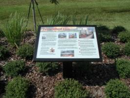
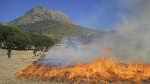
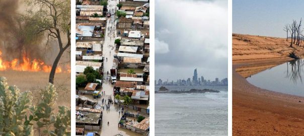
When multiple phenomena with uncertain trajectories—for example, storm surges and power outages—affect the function of cities simultaneously, the element of surprise can be enormous.  Suddenly, resources and activities that everyone takes for granted, such as mobility or an energy supply, are unavailable, causing ripple effects on people’s safety and wellbeing.

Regional Distribution of Climate Disasters. Weather- and climate-related disaster occurrence and regional average impacts from 2000 to 2008 (IPCC 2012).
Losses from Disasters (1980-2010). Overall losses and insured losses from weather- and climate-related disasters worldwide (in 2010 US$) (IPCC 2012).

Climate scientists did predict that given the expected increase in extreme events such as hurricanes, the subway tunnels in New York could flood as they did during Hurricane Sandy, but far less predictable were the many interactions with rail and road closures and the potential consequences of the shifting mobility patterns of thousands of city dwellers, especially since power outages and other system failures were simultaneously limiting the access to food supplies and drinking water.

Submerged Costal Metro Areas (Boston). This map, first published in the New York Times illustrates the potential impacts of climate change on costal metro areas. For example, 86% of Cambridge and 37% of Boston land area will be flooded in the next centuries (100-300 years) based on the estimate Sources: Remik Ziemlinski, Climate Central; U.S. Geological Survey; National Oceanic and Atmospheric Administration; U.S. Fish and Wildlife Service.

By 2030, many coastal cities are likely to face raising waters at least 4 feet above the high-tide line due to storm surges and sea level rise (Climate Central 2012).  A recent report by Strauss et al. (2012) estimates that urban areas and their communities are highly vulnerable to sea levels rising anywhere from 0 to 6 m above mean high tide.  They found important threat levels: 22.9 million Americans live on land within 6 m of the local mean high tide.

The future of Planning

Strategic decisions about urban infrastructure and growth management are based on our assessment of the past and our expectations for the future.  How we think about the future has significant implications for the choices we make and the decision-making process we apply.  Traditional approaches to planning and management typically rely on predictions of probable futures extrapolated from past trends.

However, long-term trends are increasingly unpredictable given the complexity anduncertainty of coupled human-natural systems.  Predictive models that are designed to provide accurate assessments of future conditions can only account for some of the interactions between highly uncertain drivers of change and the surprising, but plausible, futures over the long term.  Important progress has been made in complex modeling, and improved simulation and computer power have allowed us to process quite astonishing amounts of data; still, our models are constrained by our limited knowledge, unverified assumptions, and short-sighted mindsets. 

Myths in Planning 

To address the inherent uncertainty of coupled human-natural systems, we need to expose some common myths in urban planning.  I expand the discussion of the myths in a chapter in my forthcoming book Cities as Hybrid Ecosystems (2014).

Stability: Thresholds remain constant over time, and thus are predictable.

Planners have long assumed that systems are stable: that they return to equilibrium when confronted with external disturbances.  Steady state is a condition in which nature exists at or near a persistent equilibrium.  The steady-state paradigm holds that disturbance can be controlled and that by using an optimization strategy, systems can achieve sustainable carrying capacities.  Within this perspective, thresholds that would produce change to a new state (i.e., a different equilibrium) remain constant over time, and are predictable and avoidable.

But this isn’t the case.  Coupled human natural systems may exhibit nonlinear responses to perturbations.  There can be more than one stable regime.  Both the position of a threshold along a driving variable and the depth of the basin of attraction can change.  Resilience is a dynamic property.  In coupled human natural systems such as cities, reciprocal influences between system shifts in both the ecological and social systems may occur (Walker and Meyers 2004)

Optimality: There is an optimal resilient urban pattern and type of infrastructure.

The idea of optimality—that one can find the optimum among a set of possible alternatives given a set of conditions—is a direct consequence of the steady-state paradigm.  Planners come to assume that an optimal solution exists.  Decisions based on seeking the optimum assume that we can quantify risks.  However, in the presence of irreducible uncertainties, we encounter multiple plausible futures whose relative probabilities are unknown.  The farther we look into the future, the more the uncertainty increases—and it may increase even more with new understanding from advancement in scientific research.  For systems to function in an uncertain environment, robustness rather than optimality is a more appropriate target for planning and decision-making.

Transferability: What is resilient in one region and at one scale is resilient in other regions and at other scales.

Many planning strategies are based on the assumption that what is resilient for a specific system function, at one scale, and in one region, is resilient for other functions, at other scales and in other regions. In complex social-ecological systems, multiple regime shifts may occur in multiple biophysical (climate, hydrology, biogeochemistry) and human (social, economic, and political) domains at multiple scales.  Furthermore in evolving systems, changes in scale influence resilience (Walker and Meyers 2004).  Increasing the scale of urban systems may expand resilience by adding a diversity of ecosystem types, they depend upon, but urban expansion may increase the relative costs and impacts of maintaining urban activities on a larger scale.  If planners focus on the resilience of a specific subsystem, at a specific scale, that may cause the system to lose resilience in other ways. Instead, to maintain resilience we must focus on maintaining adaptive capacity and coping with uncertainty.

Adaptability: We can maintain resilience by adapting our current institutional frameworks.

Human and natural systems have evolved through change, adaptation, and extinction.  But researchers in separate domains have studied of how human systems and natural systems adapt.  As a result, we do not fully understand how coupled human-natural systems evolve and adapt and what the limits are to their adaptability.  Adaptation planners are assuming that we can maintain resilience by adapting our current institutional frameworks.  In fact a co-evolving paradigm may require reconfiguring current planning frameworks and fundamentally transforming current institutions for managing our cities.

The Myth of a Resilient Urban Pattern

Evidence that urban planning subscribes to such myths is provided by the dominant idea and search in planning for an optimal resilient pattern of urbanization.  The idea of an “optimal pattern” is based on the assumptions that thresholds remain constant over time, that they can be detected and predicted, and that what is resilient in one region and at one scale is resilient in other regions and at other scales.  Furthermore, adaptation planning is grounded in the idea that we can maintain resilience by adapting our current institutional frameworks. 

Building on the emerging evidence in urban ecology, I challenge the hypothesis that a shift in the pattern of urbanization toward a single “optimal” pattern is a desirable objective that will ensure resilience (Alberti, forthcoming).  I argue that no single pattern is consistently more resilient than another.  Resilience depends on variable biophysical and socio-economic conditions across regions and scales.  Optimizing one function at one scale may increase the vulnerability of the whole system.

In my new book Cities as Hybrid Ecosystems, I advance the hypothesis that to enable resilience, it may be necessary to create a diversity of urban patterns within and across urbanizing regions.

Resilience in Urban Ecosystems

The resilience paradigm recognizes the existence of multiple stable states and focuses on adaptation as a strategy to maintain system function.  Resilience is the capacity of a system to absorb disturbance and reorganize while undergoing change so it can retain essentially the same functions, structures, identity, and feedbacks (Holling 1973).  In coupled human-natural systems, resilience emerges from the interactions of human and ecosystem drivers, patterns, processes, and functions (below).

My colleague John Marzluff and I together with my team at the Urban Ecology Research Lab (UERL) are currently working toward a new transdisciplinary network to advance scientific understanding of regime shifts, resilience and adaptation in urban ecosystems.  This network aims to inspire, generate, and facilitate new modes of interaction and collaboration among diverse members of the scientific communities and practice to produce a new level of synthesis of existing knowledge, identify research priorities, and establish new empirical evidence on the relationships between ecological resilience and human wellbeing in urbanizing regions.

Resilience in Urban Ecosystems (Alberti, forthcoming). Credit: Marina Alberti

Evidence emerging from the study of complex systems can provide insights for planning and management. In a recent paper in Science, Sheffer et al. (2012) suggest that system shifts may result either from unpredictable external shocks or from critical transitions.  Drawing on two separate lines of investigation—on complex networks and on the proximity of critical thresholds—they suggest that both the heterogeneity of the components and their connectivity affect the stability of systems on the long run.  By building on such observations in ecological systems, we can develop hypotheses about the fragility and robustness of coupled human-natural systems and test them in urban ecological systems.

Patterns of Resilience

I suggest that the diversity of urban patterns (e.g., centralization, building density, road connectivity) may control the resilience of urbanizing regions, because it is the diversity of processes alternative patterns can support that expands the region’s capacity to adapt to a variety of conditions that can emerge in the future (Alberti, forthcoming).  In the most recent examples of extreme climate events that have tested the resilience of large urban regions across the world, the greatest surprises are in what worked: the countless ways in which unintended functions and flexibilities created by an imperfect and redundant urban infrastructure (i.e., transportation systems) provided alternatives and ways out.  When the subway floods unexpectedly and shuts down for a week, many interconnected activities will jolt, and mobility patterns will shift suddenly.  It is under these circumstances that we come to see how heterogeneous and modular the city networks and systems actually are.   Examples are provided by the power of real-time communication technology such as cell phone networks, by on-line retailers’ delivery systems, and by the redundancy and flexibility of multiple transportation and infrastructure systems.

Critical transitions pose great challenges and opportunities.  Innovation and creativity are important ingredients of resilience; at the same time they are often triggered by the same forces that drive critical transitions (Allan et al. 2010).  Critical transitions offer unique opportunities for positive transformation and generate he seeds for cities to become more resilient and innovative.  When new frames of reference and new constraints emerge, they require people and planners to see opportunities and risks they have never experienced before.  Such new frameworks highlight problems and unequal distributions, and expose tradeoffs and synergies; thus they expand the boundary conditions of what is possible and desirable.

From Resilience to Transformation

Resilience is about avoiding system shifts.  But persistence is not always desirable.  Many undesirable states, such as degraded ecosystems or social inequalities, may be quite resilient.  So while resilience planning focuses on predicting and adverting potential thresholds and system shifts, moving towards a desirable state requires transformation (Walker et al. 2004).

Resilience in coupled human-natural systems requires transformation towards what is desirable (Folke et al. 2010, Ernston et al. 2010).  This implies addressing the diversity of human values and the existence of conflicts.  A co-evolving paradigm may be more appropriate.  This view focuses not only on unpredictable dynamics in ecosystems, but also on institutional and political flexibility for learning, reconfiguring problem solving frameworks, and devising innovative policies.  Instead of seeking to reduce uncertainty, planners and decision makers will need to identify and adopt robust strategies that will be appropriate under a broad range of alternative futures.

Future policies and management practices will succeed or fail based on their ability to take into account the complexities and uncertainties of these systems.  When policies aim to stabilize the ecological system or eliminate its variability, the inevitable outcome is collapse (Carpenter and Gunderson 2001).  This is where scenario building can be valuable, as both a systemic method and a framework to expand our ability to think creatively about the future by focusing on complexity and uncertainty (Peterson et al. 2003).  Rather than focusing on accurately predicting a single outcome, scenarios let us examine the interactions between various key uncertain factors that will together create alternative futures.  Using a series of hypothetical future scenarios, we can assess the robustness of alternative strategies.

Local governments need to make important decisions about land use management and investments in infrastructure that can influence the direction of urban development in the near future.

I suggest five principles for planning under uncertainty towards enabling resilience and innovation in urban ecosystems (Alberti, forthcoming):

  • Create and maintain diverse development patterns that support diverse human and ecosystem functions
  • Focus on maintaining self-organization and increasing adaptation capacity instead of aiming to control change and to reduce uncertainty.
  • Expand the consideration of uncertainty and surprise by designing strategies that will be robust under the most divergent but plausible futures.
  • Create options for learning through experiments, and opportunities to adapt thorough flexible policies and strategies that mimic the diversity of environmental and human communities.
  • Expand the capacity for change through transformative learning by challenging assumptions and actively reconfiguring problem definition and policy action.

Marina Alberti
Seattle, Washington USA


Wicked Problems, Social-ecological Systems, and the Utility of Systems Thinking

Art, Science, Action: Green Cities Re-imagined

We had a “wicked problem” on our hands when Hurricane Sandy struck the US eastern seaboard on October 29th, 2012.  Sandy was dramatic, destroying 72,000 homes, causing tens of billions of dollars in infrastructural damage, displacing thousands of residents (many of whom are still displaced), and completely disrupting one of the largest regional economies in the world.  However, the wicked problem Sandy posed for New York City (NYC) was not the magnitude of the storm damage or any particular local disaster.  The wickedness of the problem lay in exposing the sensitivity and vulnerability of the complex social-ecological system of NYC, where a single storm event simultaneously decimated multiple components (and connections between components) of the city system.

A New Jersey beach, post Hurricane Sandy. Photo: Cheryl Hapke (USGS).

How best to get clean water, food and shelter to the thousands of affected residents of New York and New Jersey when roads were flooded or washed away, when food and fuel distribution centers were out of power and regional transportation was effectively cut-off, when people couldn’t even make a cell phone call to report they were in need?  The fact is there was no perfect solution to the problem of what to do after Sandy struck, because that is the nature of wicked problems, you only really understand the nature of the problem after you’ve started working on the solution, which is to say, after you have gotten your hands dirty trying to fix it.  This is not the way we typically think of problem solving, and it’s why Sandy was difficult to respond to.

Widespread shortage of gasoline was a example of cascading problems, far beyond the direct damage of the storm.

Responses to Sandy didn’t just call for, but required systems thinking.  Ecologists have been thinking in systems since Arthur Tansley first used the term “ecosystem” in print in 1935.  The Odum brothers (Eugene and Howard) pioneered systems approaches in ecology in the 1950s and 60s.  More recently the emerging field of urban ecology, which explicitly includes humans as fundamental components of systems, has taken a social-ecological systems approach to the study of cities.  Cities like New York are the classic example of a complex social-ecological system and systems thinking remains one of most useful tools to understand cities.  In this post I illustrate a couple case studies of how systems thinking can provide useful tools for both understanding the structure of complex systems like cities, and dealing with wicked problems.

Wicked Problems

It turns out that the nature of cities is one of fundamental system complexity, and this complexity can be wicked to understand, wicked to manage.  Sandy was a wicked problem.  Wicked problems are those that have multiple interacting systems — social, ecological, and economic — a number of social and institutional uncertainties, and imperfect knowledge, all of which apply to the state of the New York megacity immediately following Sandy.  Wicked problems are not easy to solve because it is impossible to define and describe their full nature.  Additionally, wicked problems are continually evolving.  For example, when Sandy struck New York electrical power was knocked out regionally for millions of residents by high winds and flooding, yet those with generators for their homes or businesses were not initially too worried, that is, not until the gas lines became increasingly long and fuel availability to power generators eventually went to zero.  At this point, only a couple days later, the problem initially posed by high winds and flooding had already evolved into a myriad of new problems, including how to provide liquid fuel to residents who needed it for heat as the weather began to turn cold.  What required solutions on day 1 after Sandy was very different in many places from the problems arising on day 4 and 5.  As a consequence, no single or definitive optimal policy solution to the wicked problem of Sandy could satisfy all the affected parties.  There was no perfect governance decision for a mayor or governor to make.

The man who coined the term ‘wicked problem’, urban planner and designer Horst Rittel, perceived the limitations of the linear ‘systems approach’ of design and planning over 30 years ago.  Rittel and his colleagues’ provided a foundation for what Rittel termed a ‘second generation’ of systems analysis because he found traditional planning methods inadequate for the ill-structured problems he encountered in city planning.  One of the fundamental problems with solving wicked problems is lack of information, or lack of transparency and availability of information since social and infrastructural complexity creates barriers to information sharing.

During the aftermath of Sandy, one of the critical issues at the heart of helping survivors in the hardest hit areas was information about their actual needs.  Scientists like to address these problems by creating new sources of information, but if the information is not able to flow easily to where it is needed for decision-making, what use is it?  Social complexity can cause fragmentation in the system that makes problem solving difficult or worse, impossible.  Fragmentation in information availability is a serious source of the wickedness in urban problems.

One thing we are learning from Sandy in New York, but likely true in cities in general, is that because of social complexity, solving a wicked problem may fundamentally be a social process.  Having a few brilliant people or the latest project management technology is no longer sufficient.  As Russell Ackoff, operations theorist, puts it:

“Managers are not confronted with problems that are independent of each other, but with dynamic situations that consist of complex systems of changing problems that interact with each other… Managers do not solve problems, they manage messes.”

Systems thinking and the social-ecological systems of cities

Systems thinking is a way of understanding the world, a worldview, a process of organizing information in order to understand its complexity.  But it is not the only way of organizing information and is contrasted with linear and non-linear thinking, much more common modes of understanding.  Ecologists and social scientists have taken advantage of systems thinking for decades to better understand complex systems from ecosystems to organizational systems to cities.  This includes understanding how systems respond to external perturbations, whether it’s a hurricane or economic recession, and what fundamental structures and functions are critical for resilience and sustainability.

Interconnectedness is a fundamental trait of systems and cities as examples cannot then be understood or effectively managed by focusing only on a subset of system components.  All social-ecological systems are marked by interconnectedness.  Importantly, connectivity is within and between the ecological and social components.  Indeed, the hallmark of system thinking is that it focuses on the connections and relationships, more than the components themselves.

Systems thinking is crucial to problem solving including for urban planning and policy, because no problem exists in isolation, all are part of a larger system of interacting networks; social networks, biogeophysical networks, political networks, and economic networks.  Interestingly, it turns out that you can’t understand the behavior of system by studying its parts; you need to study the whole thing.  Which poses perhaps a series of wicked problems for urban planners.

Jay W. Forrester was an early architect of systems thinking.  As he puts it:

“Systems of information-feedback control are fundamental to all life and human endeavor, from the slow pace of biological evolution to the launching of the latest space satellite… Everything we do as individuals, as an industry, or as a society is done in the context of an information-feedback system.”

Systems thinking must play an integral role in how we think about the nature of cities.  The concept of ecosystems is a cornerstone of twenty-first century science and urban ecology theory can be traced back to systems thinkers who provided much of the intellectual foundation for organizational theory.  Despite the applicability of system thinking to natural resource management, we are constrained in our ability to think in systems.  For example, virtually all natural resource managers have some formal university education, which nearly always includes traditional philosophy based on ideas of reductionism developed by Descartes.  We all “know” that the way to solve difficult problems is to break them into their component parts and solve each part in isolation.  This approach is ingrained in education and scientific knowledge.  However, the implications are largely unrecognized.

Systems thinking starts by questioning the Cartesian assumption that a component part is the same when separated out as it is when part of the whole.  In social-ecological systems, it is fair to say that we now know this assumption is wrong.  The behavior of a component depends fundamentally on its relationship with other components in the system (and on their relationships with still other components).  This is true of genes in genetic networks, it’s true of human behavior in social networks, and true of businesses in economic networks.  Urban ecologists have applied this approach for over a decade, but the application of interdependence of system components has still not been well enough understood to change the way we problem solve in complex systems such as cities.

Is the problem of hurricane-driven storm surge fundamentally a flooding problem?  Is there anything a priori particularly wrong with flooding?  Or rather, is flooding instead a problem because it is connected to issues of energy supply, economic productivity, food security, drinking water availability, transportation, and energy supply.  To solve flooding problems in highly interconnected social-ecological systems requires not only thinking about hydrology, but also about the relation of flood prone areas of the city to transportation networks (subway tunnels in NYC are prone to flooding in many areas), population density (in flood risk zones), building height (elderly living on high floors were more at risk in power outages caused by Sandy), electric cable routes (are cables underground?), backup energy supply for cell phone towers (when power goes out, so does other infrastructural functioning), and food distribution (how does flooding affect equity of food provisioning?). Luckily for New Yorkers, planners, engineers, and scientists are continually expanding our understanding of connectivity and feedbacks between components of our urban system.

Components or variables in systems undergo change, but the rate of change varies. Some variables may change quickly, others slowly.  Understanding slow and fast variables is critical to understanding how changes in one part of the system may affect other areas.  Slow changing variables can be problems when trying to alter the system, such as making it more resilient or more sustainable.  For example, policy is slow to change, because it is part of a system that tends to reinforce itself. A systems thinker will not be surprised that changes to policy are slow, whether at the neighborhood, city, or state scale.

Once you start thinking in systems, you realize the fundamental interconnectedness of all aspects, from residents’ political opinions and therefore what leaders they choose, to the number of acres of wetlands remaining in the NY-NJ harbor and their ability to absorb storm surges.  Sandy’s impact underscored the importance of a systems oriented approach to planning our way toward climate change resilience in NYC.  Just as Sandy was not an isolated incident, but part of a larger regional and global climate system that produces weather, including very rare hurricane events, the effects of Sandy on the city were also not isolated, but driven by the interwoven social, ecological, and economic infrastructure of the city.  The variation in each system component across the city allowed some areas to be more resilient to the storm than others.  Most of the hardest hit areas were low lying and directly affected by storm surges which produced major flooding, but the larger scale effects were not only driven by flooding, but a combination of infrastructure, timing, social networks or lack thereof, energy supply, and, as is the nature of complex city systems, many, many other components.

Resilience

Can systems thinking enable us to design, build, and renovate cities to be more resilient?  Since we live in an era of rapid change, including urbanization, population growth, and climate change, we have the challenge of rapid and flexible response at all levels.  Resilience theory is one of the major conceptual tools we have to deal with change at multiple levels of organization, from local to global. In social–ecological systems theory, resilience is the capacity of the system to continually change and adapt and yet remain within critical thresholds.

Diagram of community resilience. Credit: Berkes and Ross 2013.

Resilience is a systems concept, and the social–ecological system, as an integrated and interdependent unit, may itself be considered a complex adaptive system (Norberg and Cumming 2008).  As such, the analysis of community or urban resilience will likely be sensitive to the various principles of complexity ins systems, such as feedbacks, nonlinearity, unpredictability, and scale.

Resilience theory inherently deals with system dynamics and envisions ecosystems as continuously changing, sometimes abruptly and unpredictably.  In its broader context, resilience is about ecosystems and people together as integrated social–ecological systems in which social systems and ecosystems are recognized as coupled, interdependent, and coevolving.  As Fikret Berkes and Helen Ross suggest in their recent paper, applying systems thinking can help us move towards a better basis for sustainable development, one where adaptive governance is driven by a social-ecological systems approach towards resilience.

Below I describe two urban case studies to illustrate the utility of system thinking for dealing with wicked problems and understanding the complex nature of cities.

Two Urban Case Studies

Environmental Studies students at The New School have been practicing systems thinking in my Urban Ecosystems course since 2009.  They spend a full semester conducting extensive research on a city of their choice from a social-ecological systems perspective, focusing on a particular issue (e.g. stormwater, pollution, food security, drinking water, biodiversity).  Students immerse themselves in systems theory and the latest urban ecology research, and then practice thinking in systems by creating a systems diagram that describes the relationships among major variables connected to the particular issue under study in their city.  Below are two case studies from the fall 2012 course illustrating how systems thinking can provide insight into complicated social-ecological issues and point towards new opportunities for improving resilience and sustainability in the city.

Environmental Health in Greenpoint, Brooklyn

Let’s start with the issue of pollution in NYC.  The waterways around the city have historically been very polluted, in the past receiving the lowest possible EPA water quality rating in much of the harbor and surrounding areas.  Pollution levels have been overall largely reversed in recent years due to significant focus by the city to cleanup contaminated aquatic habitats, with fecal coliform bacteria now below levels determined safe for swimming in many areas, including in the Hudson river.

Still, three water bodies in NYC have been declared federal Superfund sites, including 200 river miles of the Hudson River.  There are seven more Superfund sites within the five boroughs alone, including the Gowanus Canal, Newtown Creek, three land sites in Queens, and two land sites on Staten Island.  Newtown Creek in particular is one of the most polluted waterways in the US and is home to contaminants such as PCBs, VOCs, pesticides, and heavy metals, due to countless spills and leaks from industrial production along the creek, including from over 50 oil refineries, coal yards, petrochemical plants, and glue factories, some of which are still in operation today.

Greenpoint, Brooklyn, a neighborhood with intense levels of pollution, was the focus of a study by New School student Alex Dolan.  Greenpoint has the largest proportion of industrial land in NYC, is home to multiple sources of current and historic pollution including the Newtown Creek wastewater treatment plant, a radioactive storage facility, 30 extremely hazardous waste storage facilities, 17 petroleum storage facilities, and 96 above ground oil storage tanks.  Added to this is the infamous Greenpoint oil spill consisting of 30 million gallons of oil spilled over 100 acres, equal to three times the volume of the Exxon Valdez spill, which leaked oil into soils and groundwater in the surrounding area.

When considering the spill from a systems perspective, Dolan realized the combined effect is not simply polluted water, but the pollution of a complex, interdependent social-ecological system.

Systems diagram of pollution in the Greenpoint social-ecological system, which identifies sources, pathways, interactions, feedbacks, and impacts of pollution. Credit: Alex Dolan

There are several different flows of pollutants that degrade aquatic environments in NYC, reducing aquatic biodiversity and adversely affecting human health.  In Dolan’s diagram pollutants flow from the economic system, where industry and businesses provide services and products to other industries and businesses, as well as the residential sector, which both directly creates waste and leads to other waste generation by the second tier of users.  From the economy, pollutants spread into many parts of the biosphere, here specifically to New York Harbor.  Pollutants are added to the harbor as they flow downstream from upstream sources, including via landfill leachate and through storm water runoff from city streets, which combines in sewer overflows when it rains.  Pollutants also reach the water through atmospheric deposition, which deposits particulates including laden with metals, and through the continuous burial and resuspension of sediment, which can carry PCB’s and heavy metals.

Once pollutants reach New York area waters, some degrade the aquatic environment so that only the most tolerant species remain.  Ultimately, persistent pollutants taken up by aquatic organisms bioaccumulate in the food web.  PCB’s work in this way and though their production was outlawed decades ago, they remain persistent in New York and many other waterways.  Certain species are more likely to contain PCB’s and other bioaccumulating substances and are therefore more dangerous to consume than others due to their specific habitat location and diet.  Even the safest category of fish (except Bluefish) caught in New York Harbor and surrounding waters are only deemed safe enough to eat 4 times per month, and then only by males over 15 and females over 50.

Contaminated fished are caught and eaten as an important source of food in Greenpoint homes, and pollutants move from the ecological system to the social system of Greenpoint residents.  Here, 35.7% of residents live below the poverty line with median household income only $16,409 ($10,000 below the Brooklyn mean), contributing to a high proportion of families relying on local fishing as a source of food security. In a recent study by the EPA, anglers were either Latino or African American and almost all were male between the ages of 16 and 60.  All the anglers interviewed said they were providing food for at least one family member under the age of 19.  Anglers in these neighborhoods were catching between 40 and 75 fish per week, and each family member (including children) was eating an average of 9.5 fish per week, sometimes two fish meals per day.  Those interviewed expressed the need to feed their families in an environment that was hard to find work in, and that fishing also provided an important link to traditional life. The four species most frequently caught by Greenpoint residents were blue crab, American eel, bluefish, and striped bass, all of which are listed on New York State fish advisories.

To better understand why Greenpoint residents consume contaminated fish even though advisories and posted signs around the city warn against consumption, Alex created a second systems diagram to map the relationships within the angler system.  In interviews Greenpoint anglers mention that they often have trouble finding work and that fishing is the only way they can reliably provide food for their family.  In the preliminary systems analysis, it became clear that social complexity in this system is highly connected to Greenpoint residents’ status as an at-risk population.  In the systems diagram, Alex has identified a reciprocal relationship of influence on the environmental health of the community with strong influence by cultural norms and income, and with flows of pollutants, information, capital, and social connectedness all influencing patterns of fish consumption and their effects on community health.

Systems diagram of the relationships among major components of the angler system in Greenpoint, Brooklyn, which identifies fishing habitat, fish health, community and cultural norms promoting fishing, interactions among regulations, advisory councils, and impacts on consumption. Credit: Alex Dolan

One can initially ask why government has not been particular effective in terms of influencing local residents to eat less contaminated fish, and the systems analysis helps shed light on this problem. In this case, systems thinking does not automatically point to solutions.  Rather, it is a tool for better understanding the problem, perhaps even providing a more clear statement of what the problem is, or how it is evolving.

It turns out that signage in fishing areas often warns of the dangers of fishing in English, whereas most of the anglers are non-English speaking.  Possible points of intervention in this social-ecological system may need to better recognize cultural norms and the power income has over food availability, while still recognizing the ecosystem service fishing provides to food security.  Clearly, social, cultural, political, economic, and ecological systems are all at play in influencing the health of New York Harbor and the New Yorkers who rely on it for their livelihood.

New York City Watershed and Sandy

Stephanie Valencia, another student in my fall 2012 Urban Ecosystems course, took up the issue of flooding in New York, with a focus on understanding how hurricanes like Sandy affect the hydrology of the system and result in damaging flooding effects on area residents and infrastructure.  First she realized she needed to understand the water infrastructure, including the organization of the drinking water supply for NYC.

Diagram of the drinking water supply system for NYC, including the relative locations and connections among the Delaware, Catskill, and Croton watersheds that supply drinking water through multiple reservoirs (colored) to the city.
Credit: Stephanie Valencia

To understand how hurricanes influence flooding in NYC, Valencia needed to also understand how water moves in a tropical storm system and comes ashore to cause storm surge.  In the second diagram she maps the primary drivers influencing tropical storm development as warm ocean water, winds, and warm moist air create positive feedbacks with the humidity and evaporation until the cycle on the top of diagram is created leading to a tropical storm or hurricane.  When the hurricane encounters the coast, the system changes to interact with land creating storm surges, also affected by tide and wind patterns.

Diagram outlining the process of tropical storm formation, which results in a positive feedback (in black) causing the drivers of warm moist air, winds, and warm ocean at point 1 to drive a positive feedback system that creates tropical storms. When the storm interacts with land at point 2, storms surge is created interacting with air pressure, tide, and wind patterns. Credit: Stephanie Valencia

Valencia’s effort at applying a systems approach to understanding Hurricane Sandy led her to diagram how storm surge generated at point 2 above leads into the social-ecological system of the city in point 3 (diagram below).  Here, storm surge causes infrastructural damage that in turn causes nearly all city-wide organizations in the social system to mobilize to respond to the problem of Sandy, here defined narrowly as the problem of flooding.  The infrastructural damage leads to damage of residential homes including home flooding, sewage backup, plumbing, and roof leaks causing residents to be homeless. This is damage is viewed as an input to the residential home subsystem where pollution, organic nutrients, viruses, debris, and toxicity are effects.  The effects on the residential home system drives organizations to allocate resources, funds and volunteers to create alternative methods to combat the complex interactions within the system driving gas shortages and impacts on public transportation.  Alternatives like bus shuttles, biking, car sharing, and free generator power were created in order to bring relief to highly impacted areas.  These alternatives served to improve social cohesion and collaboration toward mass recovery.

Diagram of how storm surge at point 3 is connected to infrastructural damage and how organizations mobilize to address effects driven by storm surge.
Credit: Stephanie Valencia

A fourth diagram (below) illustrates how CSOs in NYC during wet weather flow (WWF) contribute to the flooding problem with affects on aquatic ecosystem and drinking water, which in turn has effects on the social system through drinking water contamination, fishing and recreation restrictions, and biodiversity loss.

Diagram of Wet Weather Flow and interactions among storm surge, CSOS, and effects the social system. Credit: Stephanie Valencia

Clearly, there are many aspects of the system that are not included in Stephanie’s system diagrams, and that is the point. To really describe the state of a complex system like a city, we need to think from a systems perspective intuitively and recognize the vast complexity involving hundreds and thousands of interconnected, interacting variables.  The second point is to illustrate as Stephanie has done, that we can temporarily break the system into subsystems to begin the description process that may ultimately lead to improved understanding of where the points of leverage are for intervening in the social-ecological system to increase resilience to the next disturbance.

In Stephanie’s final diagram she focused on how one particular community organization, the Rockaway Waterfront Alliance (RWA), responded to Sandy as a small subset of the larger social system.  The idea here is to understand how one can slowly begin building up an understanding of the larger social-ecological system of the city by understanding particular components, such as the social organization RWA, and how it shifted their service model in the wake of Sandy to organize, support, mediate, fund, and gather and organize resources, and volunteers.

Credit: Stephanie Valencia

Systems Thinking and Wicked Problems

Noted ecologist Kevin Gaston, in his edited book, Urban Ecology, notes that urban environmental management poses a classic wicked problem, one where there is no obvious solution and the complexity of the system makes it extremely difficult to find out in advance if a proposed solution will improve resilience and sustainability or ultimately make matters worse.  For example, installing tidal barriers around New York City could alleviate the problem of storm surge, but they may also simultaneously affect the harbor economy and lead to environment impacts in the harbor in difficult to predict ways. System thinking helps us understand what is difficult to predict, which is important when urban planners and policymakers are analyzing the costs, benefits, and short and long-term effects of design interventions for improving resilience to Sandy-like events.

Sandy is now long over, and many of the effects are no longer visible in the less impacted areas of the city.  But rebuilding, designing, and planning a future NYC to be more resilient to future Sandy-like disturbances remains a challenge. Dealing with future urban disturbances means rebuilding the most affected areas to be resilient to hurricanes and also other significant disturbances, but which components of the system are most important to address to achieve resilience?

For example, NYC is very focused on buildings and water.  Clearly we need to find better ways to deal with storm surge, given the fact that NYC is low lying.  If sea levels rise four feet by the 2080s as predicted then 34 percent of the city’s streets could lie in the flood-risk zone, compared with just 11 percent now.  On the other hand, if infrastructural solutions are not well understood in the context of the complex social-ecological system, then resilience could just as easily decrease.

Can wicked problems be solved?  

Donna Meadows, one of the early pioneers of systems thinking, notes that there are, of course, complex problems that may have no solution.  Systems thinking is not in itself a solution to wicked problems, but a method for highlighting areas of intervention that can lead to potential solutions or ways to improve the resilience and sustainability of a complex system. However, in the era of Big Data the ability to understand the nature of cities as complex systems has gotten a boost with now massive amounts of data about fundamental components, which means we should, in theory, be better able to understand the relationship among components.  Take for instance New York City as a system.  We now have high-resolution spatially explicit data of all kinds.  Real-time social networking data from New Yorkers can also be downloaded and analyzed from Twitter, Facebook, Instagram, and Foursquare. Local census data provides social demographic data while land use, land cover, soil data, and other biophysical data are increasingly available at high resolution.  The list goes on.  In my last post I illustrated how combining big data with a social-ecological systems approach can open new opportunities for urban transformations.  I examined vacant lots as a particularly fruitful area where, from neighborhood to city scale, ecosystem services can be improved.

Whether it’s understanding how vacant lots can be improved to increase resilience in local neighborhoods, or how to decrease consumption of polluted food in Greenpoint, systems thinking is at the core of more clearly understanding urban environmental problems.  Until we understand that we live in a highly connected, interactive, and evolving social-ecological system, we will continue to apply our creativity and ingenuity to improving components rather than the structure and functioning of the system itself.

Finally, it is important we not make the mistake of overlooking the magnitude of social change we need. Social change is difficult, but precisely because our individual and community behavior is also tied to the behavior of other parts of the city system.  This is not to say that we don’t need infrastructural development, but thinking in systems allows us to recognize the importance of the social system as well as the infrastructural system and thus how changing physical infrastructure alone will never create system-wide resilience.  Resilience involves the ability to adapt to changing environments and an adaptive approach acknowledges that a long-term systems view is needed to deal with our very real, sometimes very wicked, problems.  In New York City, we have the opportunity, perhaps the imperative, to capitalize on what Sandy has taught us to develop more complex models and systems approaches for understanding the short- and long-term feedbacks and relationships between components of our urban system so that when the next disturbance strikes, we are even more resilient.

Timon McPhearson
New York City

Our Changing Urban Nature: Time to Embrace Exotic Species? (Or at Least Some of Them)

Art, Science, Action: Green Cities Re-imagined

Cities are melting pots.  I expect we understand this metaphor best as it relates to human beings. Cities around the world grow because people keep moving into them.  People move from nearby rural areas, from other regions in the same country, or from around the world.  When they arrive, they bring their skills, their beliefs, their music, their food, their culture…and we end up with the beautiful mosaic of urban life.  The increased movement of people and goods around the world, especially with increasingly rapid modes of transportation, is the primary way that plants, animals, and microbes get around too – either as treasured reminders of home or as hitchhikers.  So cities are melting pots of all kinds of life.

Violet in a sidewalk crack. Photo: (c) Parushin www.fotosearch.com

Some of the new arrivals (the people and all the other organisms) are welcomed with open arms.  But many are greeted warily or with open hostility.  Family narratives and history books are full of stories about about the hard times that waves of human immigrants found in their new homes.  Non-human immigrants – often referred to as exotic, introduced, or non-native species – have received a similarly cold welcome in most places.  But the movement of plants and animals across the planet is both ancient and inevitable.  It is also increasingly difficult to control.  We face choices about which movements to resist and which to allow or perhaps even encourage.  We also have the opportunity to plan as well as we can to get the most from our changing ecosystems.

Historical context for biological migration

In the pre-human past, evidence of how organisms moved around the earth is inferred from information stored in fossils (and in genes, though I won’t get into that here).  The big charismatic fossils – the dinosaur skeletons, preserved leaves – are well known, but the treasure trove of information about changing distributions comes from the microfossils.  Microfossils include preserved pollen grains, bacteria, foraminifera, diatoms, and other small things.  They tell us not only which organisms lived where in the distant past, but they are useful in reconstructions of ancient climate, dating geological events, and other kinds of historical inference.  For example, microfossils preserved in wetland and lake sediments can tell us how terrestrial ecosystems shift as glaciers advance and retreat.

Clematis pollen. Photo: (c) STEVE GSCHMEISSNER / www.fotosearch.com

For the movement of organisms throughout human pre-history we rely on the field of environmental archaeology.  We can trace how crops followed people from their centers of origin around the world, we can trace which plant and animal species were important to which groups of people, and we can observe the origin of new kinds of life resulting from domestication – the hard work of generation upon generation of farmers.

As we get into the historical era, and the origin of cities, we have written records of the migration of people and their associates around the world.  For example, ancient Greek and Chinese texts discuss the relationships between people and both domestic and wild animals and their movements across the landscape.  Another interesting source of historical information about the distributions of organisms are the biological collections in natural history museums and botanical gardens around the world.  The oldest of these institutions have collections spanning several hundred years and – when studied collectively – give a remarkably vivid picture of our changing biological landscape.

The reason I give this brief history lesson is to provide some context to what has happened since the middle of the last century.  With urbanization well underway by the late nineteenth and early twentieth century and with long-distance transit links becoming more frequent and much faster, people and other organisms began to move like never before in the history of the planet.  We know from all the sources of evidence that I just outlined that plants and animals have always been moving around – but fast ships, trains, and airplanes and booming international commerce represented a quantum leap in biological migration.  Farmers noticed a greater frequency of new weeds and pathogens, foresters and other natural resource professionals noticed an accelerated spread of new plants and animals, and scientists and conservationists wondered what this meant for the organisms in the lands and waters receiving these newcomers.  A watershed moment in the study of this movement was a book by the British ecologist Charles Elton, the Ecology of Invasions by Animals and Plants, published in 1958.

Modern perspectives on exotic species

Elton’s book not only started a new field of science called invasion ecology, it also shifted the language about this phenomenon in a militaristic direction.  These new arrivals were “invaders” that would do harm to the receiving communities.  The modern discourse in invasion biology frequently invokes military terminology: enemies battle each other, managers mount eradication efforts, ecosystems become overrun.

This may motivate action against non-native species to potentially good effect such as recruiting volunteers to manage parkland, but it also runs the risk of alienating some portion of the public.  Some will find the talk of war distasteful, but others may question why scientists and managers are using violent terminology (and actual violence) against wild animals and plants.  For people who take a “live and let live” attitude towards wildlife, efforts against exotic species can be construed as xenophobic efforts against nature.

Another serious issue with this language is that it suggests a war, but in many cases that war will not be won.  Successful efforts to manage invasive species are almost always chronic rather than episodic.  The best outcome for the manager is usually to keep the invader at bay; it is never really defeated.  Cessation of the management effort will generally lead to reinvasion, unless all individuals of the invading species, including dormant propagules, are removed or there is a change in the environment that disfavors the invader.  In cases where outright victory is unlikely (which is most of them), language about fighting to put things back the way they were is probably less useful than language about adapting to a changed environment.

Another challenge with the militaristic language on invasions is that it has led to negative feelings about introduced species generally among much of the public.  Even my environmentally-aware students and neighbors often seem disappointed when I tell them that the beautiful plant they were admiring is from some other part of the world. These negative feelings are often misplaced – the vast majority of new introductions don’t lead to any serious environmental damage.  Scientists and practitioners know this and are focused on the exotics that cause the most damage – but a less well-informed public concerned about nature my tend to associate all exotics with damage.

A grass flowering next to an abandoned building  Credit: CasaDeQueso from flickr.com

Positive contributions of exotic species 

Many of these introduced species thrive in habitats with frequent human disturbance – like so many areas in cities.  They may live side-by-side with indigenous species that also tolerate the disturbance, but their presence isn’t meaningfully detracting from their neighbors.  And these new arrivals may be adding something – a bit of shade, an extra splash of green or color in a concrete landscape, a morsel for the next link in the food chain.  To anthropomorphize a bit, they are newcomers that are willing to settle down in rough neighborhood and do their part to improve the community.  There’s something beautiful about life grabbing hold and bearing fruit in the crack of a sidewalk.

A zebra mussel-encrusted current meter near Michigan City, IN. Lake Michigan, June 1999.
Photo: NOAA

The motivation behind both the military language and the negative public perceptions comes from examples of some truly damaging invasions.  Zebra mussels in North American lakes have added hundreds of millions of dollars to the cost of managing freshwater infrastructure, introduced rats on islands have driven many kinds of birds extinct, introduced woody plants like Myrica in Hawaii and pines in the South African fynbos have fundamentally changed those ecosystems, and introduced pathogens have devastated populations of plants, wildlife, and people throughout history.  These invaders have compromised critical functions of the invaded ecosystems, eliminated other species, and borne tremendous costs to human communities.

I don’t think anyone can win an argument that says all exotic species are ok.  However, the relatively small number of clearly damaging examples has led to a bias against non-native species generally and to some misguided efforts at controlling dubiously harmful species.

A group of scientists, many of whom had studied invasive species for much of their careers, published a short paper in Nature in 2011 urging conservationists to shift their emphasis from where a species originated (native vs. exotic) to the specific functions of those species in their new habitats.  The authors make the point that the world’s ecosystems are changing rapidly in response to climate change, altered nutrient inputs, and urbanization, so the idea that non-native species should be managed to protect status quo communities of native species is increasingly obsolete.  Many invasive species management programs are very expensive and – in the long run – unlikely to succeed.  Not only is it nearly impossible to “put the genie back in the bottle”, but species composition will shift with environmental changes, just as it always has.

This paper generated significant opposition from the conservation community and from natural resource professionals who had personal experience managing damaging invasions.  Many of the counter-points from this community are also quite valid – these professionals do focus on the damaging species rather than lumping all non-natives together, we have an obligation to attempt to stop extinction from damages wrought by humans, and many invasive-species management projects have been successful, at least at local scales and over short time periods.

Exotics in the city

The broader point I take from this debate for cities is that we should engage in a critical discussion about our goals in managing urban vegetation and wildlife.  Cities already represent a significant change from the indigenous landscape – altered land cover, climate, hydrology, chemistry, soils, disturbance regimes, and a suite of other factors.  And as much as the physical environment of cities has already changed, in most parts of the world it will change even more – and possibly more rapidly – as climate change affects the timing and intensity of storms, sea levels rise, and growing urban populations increase demands for food, water, and energy.  Add to all this physical change the immigration of new plants and animals connected by global trade and human migration and you realize we are facing a future where it would be foolish to believe that our urban environments should look or function exactly like they have in the past.

This is not to say that I think we should give up on preserving native species or managing for native-dominated systems in urban landscapes.  There are many good reasons to favor natives where feasible: native species may provide goods or services that we value more than exotics, species that have coexisted for long periods form complex networks that be more stable or higher functioning, we have an ethical responsibility to care for the land and its inhabitants, and there is real value the connection between people and familiar environments.  Even in cases where it is hard work to protect native species, the benefits may outweigh the costs.

However, this calculus isn’t always easy.

Two examples from New York City

In New York City, one of the major invasive control programs involves removing exotic vines, largely porcelain berry (Ampelopsis brevipedunculata) and Oriental bittersweet (Celastrus orbiculatus), from forested parkland.  These vines, both from temperate Asia, grow vigorously in canopy gaps and prevent the recruitment and growth of trees that would, in the absence of the vines, grow up and close the gap.  Forest ecologists from the NYC Department of Parks and Recreation Natural Resources Group have mapped vine-dominated canopy gaps through time and found that forest succession is arrested by the presence of abundant exotic vines: vine-dominated patches tends to stay vine-dominated patches.

A canopy gap dominated by exotic vines in New York City. Photo: Tim Wenskus

As part of a citywide effort to add forest canopy, Parks has invested significant time and money to remove these vines and plant young trees.  They manage these reforestation sites for years after the tree planting, primarily by removing vines that have regrown.  Their expectation (and hope) is that some of the young trees will grow and close the canopy gap, reduce light to the understory, and inhibit the regrowth of the vines.  Over time, urban forest canopy will increase, light and soil resources will be captured by trees and thus be unavailable to the vines, and Parks can scale back their maintenance.  This intervention could shift the system from vine-dominated patches to tree-dominated patches and improve some services: more carbon storage, better stormwater management, and improved visitor access in the closed-canopy forest, but with some loss of the fruit resource the vines provided to wildlife.  On the whole, this would improve the parks and could be a case of effective long-term management of exotic species.

A stand of Japanese knotweed along the Bronx River, New York City. Photo by Matt Palmer

As a second example, Japanese knotweed (Fallopia japonica, synonyms Reynoutria japonica and Polygonum cuspidatum) is an herbaceous perennial originally from Asia and now common to riparian wetlands, roadsides, and waste places throughout New York City.  Knotweed can grow in very dense stands that displace other kinds of vegetation – a stand of knotweed is often just knotweed.  The banks of the Bronx River support very large populations of knotweed and other exotic species which the NYC Parks department is beginning to manage.  The primary goal of this management is to improve conditions for native plants and wildlife in and along the river. They accomplish this through the physical removal of knotweed (excavating rhizomes from soil – backbreaking work) or by spraying with herbicide.  Removal is followed by replanting native shrubs and herbaceous plants.  The expected return for this effort is the recovery of high diversity native vegetation, which will support both terrestrial and aquatic wildlife.

Underneath a stand of Japanese knotweed – more knotweed and knotweed litter. Photo: Jacoba Charles.

Managing the knotweed long term will be challenging.  It spreads quickly by rhizomes and fragments and – unlike the vine example above – it is not clear that the establishment of native vegetation will prevent the reinvasion of knotweed.  To maintain diverse native communities in this park may require a long-term commitment to removing knotweed.  The protection of native plants and wildlife in high-value sites like Bronx River may be worth the effort, but I have lately begun to wonder about the broader set of functions that knotweed may provide.  It can grow rapidly in a range of habitats and thrives in poor soils.  Stands of knotweed are productive and the roots and rhizomes secure soil on slopes, likely preventing erosion and perhaps trapping sediment from floodwaters.  Honeybees collect pollen from its abundant flowers and the young shoots are edible.  Research on the ecosystem effects of knotweed invasion in Europe is mixed, showing some positive, some neutral, and some negative changes relative to non-invaded stands.

When knotweed is displacing high-value riparian vegetation, perhaps we should manage it intensively to protect native biodiversity.  But when it is growing on marginal lands and the costs of invasion are lower, perhaps these benefits outweigh the costs.  There is so much knotweed in New York City there’s no way we could effectively manage it all, but perhaps we should look at though a utilitarian lens rather than focusing on it’s geographic origin.

Reconciling with exotic species

The realization that cities are experiencing rapid environmental and biotic change should be forefront in our minds as we choose targets for the living infrastructure of our cities.  Which biological invasions should we manage and which should we just allow to proceed?  For those invasions that we choose to manage, how will know we have succeeded?  Or when will we decide to stop trying?  When planning a greening program, what is our target in terms of ecosystem structure and function?  What suite of species, both native and non-native, will get us to that goal?  When choosing species for green infrastructure, are we choosing species that will do well in the in city in 2030?  What about the city in 2100?

At some level, I am disappointed by the realization of all this change. I like the indigenous biological communities of the region where I live. But I also realize that the ecosystems that will replace the preceding system will have their own appeal – both aesthetically and functionally.  I take some hope in the imagery from a post by Stephanie Pincetl last summer about the riot of trees from around the world growing in Los Angeles, which sounds pretty great.  The recent post by Eric Sanderson about learning from (native) species about resilience to storms reminds me that the new systems will still be based on the same template as the historic system.  Exotic species only rarely result in massive changes; the more common result is an iterative revision to a functioning system – forests still grow and rivers still run.  And perhaps the next version of the system will even benefit from the new arrival in the melting pot.

Matt Palmer
New York City

Celebrating the Natural Soundscapes of Cities

Art, Science, Action: Green Cities Re-imagined

In recent presentations about green cities and green urbanism I often play for audiences several common natural sounds, to see whether they recognize what they are hearing.  Here is one of the sounds I often play—something commonly heard in communities in the eastern US.

Click here for a mystery nature sound.  Do you recognize this?  A little later in the post I will tell you what it is, and you may be surprised.

The fact that so many fail to recognize these sorts of common nature sounds suggests something about our disconnect from the aural realm, perhaps the fact that we have lost the skill or desire to carefully listen to the world around us.

The subject of sound needs to be more squarely on the agenda of urbanists.  We have tended in the urban planning and design fields, in which I teach, to privilege the visual, to celebrate the ocular.  Unfortunately, this often results in lesser attention given to the other sensory experiences that make up our lives.  I have become especially concerned with sound, and its persistent under-recognition as a key factor in quality of life and in overall human health and happiness.

Much of what makes me happy and content involves the things I hear, and much of that has to do with the rich and complex sounds of the natural world.  Biophilia, and biophilic urbanism, are in essential ways multi-sensory, and sound is a key dimension.  A natural soundscape is an essential aspect of livability and quality of life, I believe.  Hearing these beautiful sounds makes us happier, as does seeing and experiencing the animals and nature that produce the sounds.  However, we have left the management and stewardship of urban soundscapes to chance.  It is time for cities to assume some badly-needed sonic leadership, and as the discussion below suggests there are in fact many things that cities can do.

The biophilic soundscape of cities

A tree frog—a “peeper”—from the eastern US. Photo by Tim Beatley

There are many natural sounds that I look forward to everyday and some I count on to mark the seasons of my life.  I look forward to hearing the spring sounds of peepers, for instance, and to the glorious and cacaphonous sounds of birds.  The summers along the eastern US present perhaps my favorite aural season, with evenings full of lulling katydids, crickets and tree frogs, among others, inextricably linked in my own DNA with humid and hot lazy summer evenings.

Click here for a sample of nighttime sounds in Virginia in late summer.

There is no end to the diversity and complexity of the natural sounds around us, it seems.  Bird songs are a mainstay, of course, and winter finds literally hundreds of robins cackling and chirping at daybreak outside my central Virginia door.  And there is the tap of the pileated woodpecker, more like a wood sculptor skillfully swinging a mallet than digging for grubs.  But there are natural sounds of many kinds, from voles to bending trees and wind-rustled leaves, even to the sounds of eastern woodland snails eating, if we listen closely and carefully (as Elisabeth Tova Bailey so eloquently tells us in her beautiful book on this topic, The Sound of a Wild Snail Eating; and no wonder, as they have some 2640 teeth!  You can hear a small snippit of the snail eating at Bailey’s website here.

Pileated woodpecker. Photo: (c) Kellyplz / www.fotosearch.com Stock Photography

Few scholars of sound are more accomplished than Bernie Krause, who has been collecting and analyzing natural soundscapes around the world, and what their changes tell us about ecology and biodiversity (most especially in his recent book The Great Animal Orchestra).  Krause distinguishes between geophonies (running water, moving trees, the rumble of moving glaciers) and biophonies (sounds emanating from living organisms), painting a picture of soundscapes of incredible diversity and complexity.  From blue whales to ants to corn growing, Krause argues all life is sound-generating, and moreover we have co-evolved with these sounds and connect with them and enjoy them in important ways.  “It is likely that buried deep within the human limbic brain is ancient wiring that springs to life every time we reconnect with these delicate webs of acoustic finery…” (Krause, 2012, p.105).

Listening to these deeply nourishing sounds—what Rachel Carson has called “nature’s music”—serves to calm me, steadies me, reassures me that I am in the right place, and causes me to remember family and childhood in a deep and visceral way that few other sensory experiences can.  Indeed I would argue that biophilia is very much a multisensory experience, by definition, delivering much of the therapeutic power and punch that nature provides us.  Natural sounds are an important entre into the mystery of life around us, a kind of aural portal or window into the complexity and diversity around us.  In an age where so many things seem to be known or knowable, there are many sounds that essentially convey a mystery and wildness that we lack in other dimensions of life.

I think we need to do a better job celebrating the soundscape, cherishing those special sounds in our lives, and protecting the natural soundscapes that exist, as well as referencing these valuable benefits when we work to protect and restore natural spaces in urban settings.

How do we know that natural sounds are beneficial?  We have considerable anecdotal evidence, of course.  There is the interesting example of the Southern California city of Lancaster, where, through the leadership of the city’s mayor, R. Rex Parris, a network of 70 speakers plays bird sounds along a major boulevard.  The mayor claims that minor crimes have gone down as a result.  “Everybody is now is a better mood, a better place,” Parris told the Wall Street Journal.  The positive calming effects are believable to this author, though one wonders about the merits of artificial broadcasting when the goal should be to protect and foster a healthy natural soundscape (and sufficient urban habitats to ensure real bird sounds).

Studying the natural sounds of cities is an increasingly important dimension of urban ecology, as recent studies have shown.  It is interesting that the non-human inhabitants of cities seem to find ways to adapt to urban noise, perhaps more cleverly than we have.   Recent studies have shown how background noise can disrupt grasshopper mating calls in cities, for instance, but also how these species adjust the frequency of their calls in response (BBC Nature, 2012) [To listen to calls of the male bow-winged grasshopper visit here.  Similarly, birds such as sparrows have also been shown to modify their songs in response to noisy urban traffic (e.g. Science Daily, 2012).

What can cities do?  Manage noise to foster nature-connections

Not all urban sounds are pleasant of course; many are not.  Modern society is full of ubiquitous mechanical and engine sounds—cars and airplanes in particular—that seem ever-present and serve to destroy and drown out the sounds of nature.  We rightly worry about the health implications and negative impacts of high-decibel sounds on hearing, but often tend to overlook the lost positive values and life-enhancing value of hearing nature and natural sounds.  Controlling these mostly negative elements of our collective soundscape is a major challenge for us.

Many of these sounds—the noise—are indicative of patterns of unsustainable living and consumption.  The fall season along the eastern U.S. brings many sounds that represent energy consumption and air pollution—one thinks notably of the ubiquitous presence of leaf blowers: two stroke engines that bellow so loud that conversation even indoors becomes difficult, and supplant human labor and care with air polluting, fossil-fuel-burning force.  There is an irony that in a time when many Americans would benefit from greater physical activity (i.e. raking leaves) the leaf-blower emerges as an affordable technology, and one that further disconnects us (think of the ear-protection users wear) from outdoor nature, and from other humans as well.

More aggressively controlling the noises from cars is another important step.  The European Union has adopted and will be phasing in overtime new auto tire standards that will significantly reduce tire noise, and this is a good step.  The shift of slowing traffic in many urban neighborhoods (or eliminating car access altogether) is further supported by the benefits of being better able to hear the natural sounds there.  Car-free urban districts, more common in European cities, are one way to protect and celebrate the natural sounds present in cities.

Most of the policy and community planning agenda related to sound has (perhaps understandably) mostly to do with noise—the  loud and negative sounds that make life unpleasant, sometimes undermine our very health and wellbeing, and the spaces in and around cities (for instance, under airport approach zones) that are almost uninhabitable.  Planning and design often seeks to control and moderate these noises—for instance through land use planning aimed at keeping residential development out of noisy areas, design of structures (windows, building materials, interior room layout) to minimize noise, and other efforts to reduce the decibel levels of the noises around us.

In some cities around the world—for instance, Scandinavian cities—emphasis in city planning has been placed on finding and protecting “quiet areas,” where peaceful contemplation and reflection, and quiet recreation, prized commodities in a large city, can occur.  More cities should seek to designate and protect such areas, and enlist the benefits of spaces where a call of a lark or a squirrel, or the creak of a tree moving in the wind can be heard and enjoyed.

We often tend to emphasize those sounds that are negative or dangerous or unpleasant, but we rarely work to understand what the important positive and therapeutic sounds are in our communities.  Indeed, as planners we have generally failed to acknowledge or incorporate sound (and other senses besides sight) as a planning element.  Sounds, the soundscapes of a city or town, are a highly underappreciated aspect of community.

Designing homes and neighborhoods with sound in mind

We need to better study and take account of sounds in the planning and design work that we do.  One step is to begin to systematically record, inventory and document the sounds, natural and human made, that exist in our communities.  We are increasingly likely to advocate and expect a host of new urban greening measures—from rain gardens, to tree planting, to use of native landscaping in public parks and greenspaces—and while we may be intimately aware of their hydrologic benefits, for instance, we are not likely to take into account the impressive ways in which these green features enhance and expand our natural soundscape.  No-mow zones around buildings can do much to enhance the natural sounds we experience every day, though these sounds are typically never part of our rationale or calculus.

Many communities now commonly undertake visual preference surveys as a way to extract important design principles and insights (showing a series of images of buildings, streetscapes, urban environments and asking respondents to indicate how much they like what they see).  To my knowledge, however, no community has sought to catalog, record and poll its citizenry about the kinds of sounds it enjoys or cares about (or worries about conversely).  Cities should consider using this kind of aural preference survey.

Listening to a water feature. Photo: Tim Beatley

We know the sound of water in cities is soothing and therapeutic as well, and a major additional reason to support efforts at river restoration, and stream day-lighting in urban neighborhoods.  On a recent visit to Oslo, I recorded the fast moving water of several streams, including the Akerselva, a beautifully restored waterway that runs through much of that city.  With hiking and biking paths, and numerous small bridges that allow crossing the river at key points, it is both a mobility asset and a green urban spine, and one that provides numerous points for sitting, picnicking, and rolling in the grass, all within earshot of the sounds of moving water.

Oslo, June 2010. Photo by Tim Beatley

Click here for sounds of the Akerselva River in Oslo.

One of the modern challenges of healthy sustainable living in the USA is overcoming the predominately indoor-oriented lives that most Americans experience.  Green neighborhood designs can help to correct this.  For instance, tree planting and creative green elements can, through shading and evapo-transpiration, effectively replace ubiquitous air conditioning and help to reacquaint Americans with open windows and doors, and the ability to overcome the physical barriers to hearing place sounds.  Village Homes, in Davis, California, is an inspired and early green neighborhood with this goal.  Extensive green landscaping, and passive solar designed homes, have created the conditions for closer contact with the outside world.  As Judy and Michael Corbett discuss in their terrific book about the neighborhood:

“Elimination of the need for air conditioners by means of our natural cooling system creates a quiet neighborhood and allows us to be more in touch with the natural breezes and smells of summer” (Corbett and Corbett, 1999).

Some new home designs, furthermore, are creatively incorporating listening elements that collect and project outdoor sounds into indoor living spaces.  Architects Joel Sanders and Karen Van Lengen have recently designed a prototype of a suburban house of the future, the MIX house, that creatively collects sounds and images from the sky and surroundings and projects them into the spaces of the house.  They envision use of a series of “audiovisual” or “sonic” windows that when closed (imagine winter weather?) collect both sound and images, as well as a large tilted ceiling that collects the images and sounds from the sky into the master bedroom.  These ideas are unique for home design and architecture which, as the designers note, has tended to reflect an “ocular-centric design culture.”

And perhaps larger buildings can be designed to facilitate aural experiences that connect us to nature and place.  There is the example that comes to mind of the apartment complex that fellow The Nature of Cities collective writer Mike Houck took me to in Portland, Oregon, where the rainwater is collected and steered to a series of courtyard water features.  Here, at 10th@Hoyt, residents reportedly come out on stormy days to listen to the rain, as it falls and makes its way down and through an elaborate system of “runnels and chutes” (Echols and Pennypacker, 2006).

Natural soundscapes as an important dimension of city planning

For those of us involved in city planning, we must find ways to integrate sound into our work—community comprehensive plans should have a sound element or chapter, and our vision statements for the future should reflect the important goals we have for our community sound environments.  Perhaps we begin to formulate and express our parks and greenspaces targets to reflect a sound dimension—e.g. the goal that every neighborhood in a city reach conditions in which on any given day residents can easily hear (let’s say) 10 bird species.  Many cities, such as New York, have established a goal of minimum access to parks—say every resident able to reach a park or greenspace within 5-10 minute walk.  Perhaps such targets could be expanded to include not just a park, but a quiet space (within the park perhaps?) where it is possible to hear crickets?

I can also imagine instituting some form of natural soundscape performance standard for new buildings and development: requirements, for instance, that new developments prepare aural impact statements that make an honest attempt to judge likely soundscape impacts, and to mitigate them in some clear ways (e.g. new trees and vegetative elements that might help to compensate for a development’s reduction in natural sounds and increase in mechanical and human sounds).

We need to better study and take account of sounds in the planning and design work that we do.  Every city might start then by preparing a sound map, a kind of inventory or aural assets.  Each community, each place has its own soundscape, its own unique sound signature.  Understanding this signature soundscape, and monitoring how it changes over time, should become a common planning practice.

In my own community we have begun to develop, over several years, and with the help of my students, a community sound map, as an initial effort to take stock of the many sounds that we take for granted.  Every community needs a sound map, perhaps even a sound plan.  With the help of my students we have been recording snippets of sound throughout the city.  Understanding the unique and special sounds one would hear on different (sound) walks, we are beginning to understand the physical spaces around us are filled not with noise but with beauty and meaning and connection (though there is some noise to be sure; see here).   In the process we are collectively learning to listen again—to hear things that we may have not been aware of, to savor the aural flavors and nuances and to celebrate the connections to other life that really, truly listening can afford.

Of course not all sounds are pleasant to the ear.  Many are mildly annoying (dogs barking at night), seriously stressful (airport approach and departure sounds), and some are alarming (e.g. police and fire vehicles).  Like other aspects of our lives, perhaps we should not aspire to a world of only pleasant sounds, but recognize that a life fully lived in a community is one of many and diverse experiences, some pleasant, some not so, and some sounds that are recuperative, others that are disturbing, but all make up the soundscapes of our lives.

Just as landscapes change in a community and region over time, so also does our experience of sound and in fact recording and acknowledging what we hear is a kind of proxy for those changes.  We are understandably concerned when we lose certain lands and habitats in and around communities, but for me part of what that is unfortunate is that we often also lose the special sounds that those spaces provide.  Sounds and soundscapes then offer another window or measure or marker for understanding the change in our communities.  Not all of these changes to the community soundscape are negative, of course, but many are.  And it is rarely the case that there is much explicit discussion (or any) of the diminished soundscape that community changes typically wreak.

Hearing the nature around us

Despite the many competing sounds and noises in cities there is much to hear if we try.  Too often we don’t try, and like the failure to recognize plants and animals visually (that common species of tree or bird) we don’t recognize the sounds that we do hear.

Let’s return to the natural sound presented in the beginning of this essay.  Did you know what it was?  At once exotic and unusual sounding, most audience guesses are wrong. Many suggest a tree frog, but most are baffled. I then show a photo and usually the audience is quite surprised to see that it is the call of the eastern screech owl.  It is seemingly an exotic sound, a twittering and a horse-like downward whinny.

Screech owl. Credit: (c) Namwar69 / www.fotosearch.com Stock Photography

It is a common co-inhabitant of urban and suburban environments.  I must admit that what initially led me to this unique sound was hearing it my backyard one evening.  It is a sound that once heard is not easily forgotten, and indeed a very common sound in suburban neighborhoods throughout the eastern U.S.  Yet it goes unrecognized and we miss the opportunity to acknowledge and enjoy the life around us, in this case the special night sounds that make leaving the windows open in the evening so enjoyable.  Knowing that sound (it turns out that screech owls don’t actually screech!) moreover, deepens both my understanding of but commitment to that place in which I live, and I have found myself on many nights longing to hear the screech owl again, as a kind of returning friend, an important and valued member of community and neighborhood.

The sound signature of each community will be unique and different, of course, and is at least a part of what makes a place special and distinctive.  Many of these sounds are human-made (and not all them noise), and it is the unique blend of sounds that makes a unique signature.  On a visit several years ago to Iowa City, Iowa, home to the University of Iowa, I discovered some interesting ways in which that city’s and region’s soundscape is distinctive or different.  The university’s power plant, for instance, has historically blown a whistle to mark time, four times a day: 8am, 12noon, 1pm and 5pm.  It’s a distinctive whistle to be sure; it got my attention when first I heard it.  And several years ago they stopped the practice briefly, with the understanding that the time-marking function of the whistle was no longer needed.  But there was a community backlash from the decision and the whistle was restored.  In this city the whistle has become a reassuring and familiar sound, a part of the city’s identity, indeed its self-identity.  There are countless other sounds—from the low clattering of plates, dishes and silverware of outdoor restaurants, to the distant rumble of a train, that can blend together pleasantly.

Part of the challenge moving forward may be that we need to learn (or is it re-learn?) how to truly listen in the places we live.  We will need to cultivate a curiosity about what we hear, and ask ourselves, and each other, what or who is making a particular sound. But we will also need to find the resolve to be still and quiet occasionally, to resist the buzz and bell of our cell phones, long enough to hear the wonderful voices of the life around.

Tim Beatley
Charlottesville, VA USA

What are some of your favorite urban natural sounds?  Take a moment to record one of them and send it to [email protected].  We will try to post it here.  MP4 or WAV format please, and no more than 60 seconds long.  Include as the title an identifcation of the sound and where and the date it was recorded.  Please, only sounds you have recorded yourself.

House Sparrows. Near Union Square, Manhattan, New York City. 12 January 2013. Recorded by David Maddox

From Banlieue to Biophilia: Thinking About Nature as a Basis for Urban Design

Art, Science, Action: Green Cities Re-imagined

My second contribution to the Nature of Cities blog was scheduled to fall around that awkward moment at the start of the New Year when productivity is at its lowest ebb. Instead of sitting down to the task at my own snow-bound desk in upstate New York, I find myself seated on a plastic chair in a poured concrete garage smack-dab in the middle of rural Portugal.  The sun is shining through an open door, the flies are buzzing around a stack of old wine bottles in the corner, and a rooster just announced his presence in the yard out back.  I’m on vacation, you see, visiting family and spending time in a part of Portugal that has, in many ways, opted out of the networked society that so completely defines my life back in the U.S.  There are four channels on my aunt’s television set.  No stray WiFi signals show up on my computer.  News still travels efficiently by word of mouth, and neighbors pass the time gossiping at the front gate with anyone who passes by.

On the street in rural Portugal with the author’s family. Photo: Philip Silva.

Being that I’m on vacation, this blog post is less of a watertight exposition on a single topic than a meander through some loosely connected ideas about cities and nature.  There’s little around me right now to inspire any reflection on cities, yet there are seemingly endless opportunities to contemplate nature.  For miles around, this ancient coastal plain is checkered with allotment farms, pine forests, and opportunistic stands of eucalyptus trees.  Much of the rural, self-sufficient lifestyle rhapsodized about in cities back home in the U.S. is unassumingly lived out here, with little conscious thought given to things like environmental sustainability, locally-sourced food, or cultivating a “sense of place.”  People grow their own cabbages and onions, potatoes and garlic, and it’s hardly cause for adulation.

Capucho, Portugal, near Lisbon. Photo: David Maddox

Yet this is Western Europe, after all.  Rural though the setting may be, the fact remains that these lands have been trampled upon, cultivated, exhausted, fertilized, subdivided, colonized, and conquered millennia.  Aside from the wildlife sequestered in a few national parks, little of what the eye beholds here is likely to be “native” in the strictest sense of the word.  It’s all been shaped, to one degree or another, by human hands with the purpose of serving human needs and fulfilling human dreams.  It may look like nature, but the landscape was irrefutably drawn by social and cultural forces.

This problem of defining and delimiting nature – especially when it comes to nature and cities – has bubbled up in more than one contribution to this blog since its inauguration.   My first post last July dealt with the idea of cities as cyborgs, collections of artificial and natural materials and processes inextricably fused together to form urban settings.  In August, Brian McGrath introduced the idea of a “nature-culture continuum,” urging us to go beyond simply finding examples of nature in cities (trees, green spaces, animals, etc.) when we speak about the nature of cities.  More recently, Stephanie Pincetl helped us see the city’s built infrastructure, crafted from stone and steel, as an important part of any conversation about green infrastructure and sustainable urban living.  Put another way, Pincetl encourages us to recognize and value the inanimate dimensions of urban nature, though we tend to focus on biological systems in these discussions.  For the remainder of this week’s post, I want to consider this emphasis on biological systems in our discourse on the nature of cities.

In his introduction to Uncommon Ground, a pioneering collection of essays published in the mid-1990’s, environmental historian William Cronon made an exhaustively strong case for critically deconstructing the seemingly fixed concept of nature.  Cronon and his colleagues argued that the idea of nature couldn’t be taken for granted, its definition assumed to be universal or everlasting.  Nature, it turned out, is a slippery concept.  Though Cronon’s task was deconstruction, his aim was, in the end, the creation of a more stable conceptual footing for the modern environmental movement.  I’ll let him speak for himself:

“… our essays may be perceived by some as hostile to environmentalism, part of a general backlash against the movement.  And yet nothing could be further from the truth.  Indeed, it is precisely because we sympathize so strongly with the environmental agenda – with the task of rethinking and reconstructing human relationships with the natural world to make them more just and accountable – that we believe these questions must be confronted.  To ignore them is to proceed on intellectual foundations that may ultimately prove unsustainable.”

Most of the essays that comprise Uncommon Ground ask us to think twice whenever we turn to nature for solutions to human problems.  It’s not that nature doesn’t offer valuable lessons.  Yet our ideas of nature are inevitably cultivated from our cultural assumptions and prejudices.  When we look at nature, we can’t help but see it through a distorting cultural lens.  For humans, nature is something like a story to be told (and re-told) rather than objective reality that can be exhaustively understood on its own terms.  When we look to nature for inspiration in tackling urban problems, we need to carefully consider how much of that inspiration actually comes from a tacit set of human values and beliefs.  Nature, it would seem, is what we make of it.  What, then, do we make of cities designed in nature’s image?

The idea that nature offers untapped solutions for urban problems is not entirely new.  At least a century ago, the Garden City movement called for cities that more closely resembled the countryside, with lower population densities and more acreage given over to green space.  The same planning  ideas would live on, albeit distortedly,  in the form of Modernist “towers in the park” – an urban design strategy familiar to anyone who’s spent time in a North American housing project or a French banlieue.

Lisbon, Portugal. Photo: Philip Silva

In recent years, the concept of biophilia has inspired some efforts to make cities more livable and sustainable. I n his blog post earlier this year, Tim Beatley described biophilia as the notion “that we are hard-wired from evolution to need and want contact with nature.”  There are two concepts at play in Beatly’s description.  First, there’s the core notion of biophilia, an experience of love or attraction to living biological systems.  Then there’s the biophilia hypothesis, first put forward by the celebrated biologist E.O. Wilson in 1984.  The hypothesis posits that human beings, having spent much of their evolutionary development as a species in nature, are inherently drawn to natural settings.  Designing a city with biophilia in mind means making space for nature, however one defines it.

On the face of it, this would seem to be a common-sense approach to solving some of the environmental ailments found in contemporary cities.  Yet creeping in the background is all that stuff from William Cronon (and others) about the slipperiness of the concept of nature – especially when it comes to determining what is and isn’t “natural” in cities.  Is nature just “the green things” that we find in cities?  The parks and trees and rivers and shrubs and everything else that wouldn’t be out of place in a rural setting like the one I find myself in right now?  Or are even the most developed cities already natural places, regardless of how artificial they seem?  Eric Sanderson made a fine case for moving past this dichotomy in his post earlier in the year, helping us “conceive of cities in their entirety as ecological places.”  Yet if cities are already quite natural on their own, where does that leave the biophilia hypothesis as a prescription for environmentally sustainable and livable cities?

I want to offer three short – and, admittedly, incomplete – observations that I hope will spark further conversation around these themes.  I’ll keep my points brief, mainly because I’m not resolutely devoted to them and I’m curious to hear what others have to say in response to each general idea.

Biomimicry beyond biophilia?

Biomimicry is the idea that natural processes may hold within them the blueprints for engineering sustainable human technologies.  Examples abound, from sewage purified in  ersatz “living machine” wetlands to synthetic fibers spun in factories with as little impact as a spider weaving its web.  Biomimicry promises a future where the materials of an industrial civilization leave no more of a lasting trace on the earth than the objects in a neolithic hunter-gatherer’s toolkit.  Janine Benyus’ Biomimicry and William McDonough’s Cradle to Cradle are both must-read primers for anyone interested in learning more.

All cities rely on technology.  Their infrastructures are a complex tangle of human life-support systems, and like any cluster of technologies, they may be made more sustainable  through biomimcry.  We might think of “green infrastructure” as low-hanging fruit; a kind of first pass, low-tech approach to biomimcry for urban technology.  Instead of re-engineering a sewage treatment plant to function like a wetland, just create a wetland.  In the process, you’ve created a place for humans to experience a biological system within the city.  Green infrastructures are where the concepts of biomimicry and biophilia overlap.

A house in Lisbon. Photo: Philip Silva

However, there remain countless technologies and industrial materials that don’t readily lend themselves to a green infrastructure alternative, all of them integral to the daily function of contemporary cities.  Moreover, in dense mega-cities, green infrastructure may not be able to carry the burden of tens of millions of people, and you’d be hard pressed to plunk down a wetland in the middle of Manhattan.  In these instances, it seems to me, biomimicry trumps biophilia.  Build a sewage treatment plant, and design it to function as much like a wetland as possible, drawing on whatever science tells us about how wetlands work.  The two ideas aren’t mutually exclusive, but there’s a continuum of feasibility that needs to be appreciated.

Sociobiology – biophilia’s conceptual underpinning – is a contested idea

The biophilia hypothesis grew out of sociobiology, a field of research predicated on the idea that human behavior and culture are products of the biological evolution of the species.  Like biophilia, the field owes its development to E.O. Wilson, who set down the parameters of sociobiology in the mid-1970’s.  Sociobiology held out the promise of synthesizing the natural and social sciences for a comprehensive approach to understanding humankind.  However, the field was not without its detractors.  No less an authority than evolutionary biologist Stephen Jay Gould would, along with others, criticize sociobiology as a narrowly “deterministic view of human society and human action.”

There isn’t enough space on this blog to rehash the many debates that followed Wilson’s publication and Gould’s critique.  My point here is simply to emphasize that sociobiology, which gives the biophilia hypothesis its underlying logic, is not a universally accepted approach to understanding humankind.  In fact, the debate continues to this day, with significant arguments against sociobiology coming from scholars across the social sciences.  Yet in many of our efforts to draw on the biophilia hypothesis to create greener cities, we treat the concept as an established fact.  I won’t take a stand one way or another right now, but I do think we need to let the debate into our discourse on the nature of cities in order to make our work more resilient, rigorous, and, ultimately, more relevant.

Is biophilia bigger than “Nature”?

If we hold the biophilia hypothesis to be true, then what are the qualities of biological systems and “natural” settings that make them so attractive to humans?  How do we evaluate an urban setting to determine whether or not it adequately answers to the biophilia hypothesis?  How does the human eye – and the human heart – tell nature from its own creations?  Does a hardscrabble community garden make the cut?  A lonely street tree?  What if it’s an Ailanthus, that much-reviled invasive plant that thrives so comfortably in cities?  We’re back to that issue of defining nature, in all its slipperiness, in order to better understand biophilia in cities.

Graffiti on a wall is Lisbon. Photo: Philip Silva

As a result, I struggle with how nature is defined when the biophilia hypothesis is applied to urban planning and design.  I have a hard time lumping a single tree, a community garden, a wetland, a window box, a green roof, a flock of birds, an urban park, or any number of other phenomena all into the same category.  And, despite contradicting myself, I also wonder we’ve taken too narrow a view of the things that trigger a biophilic response in cities.  If a garden can elicit a feeling a biophilia, why can’t any other object of beauty crafted by human hands?  If we celebrate the presence of nature in cities because it provides unique opportunities for surprise, wonder, and reflection, what other aspects of urban living fulfill those needs?  I personally feel the same magnetic pull from a technicolor graffiti mural as I do from a well-designed park or a lovingly maintained garden.  All three grab the eye with the visual equivalent of a complex polyrhythm.  All three are vibrant expressions of life, human and non-human alike.

What might we discover if we keep pushing the boundaries of biophilia, including more and more things that don’t normally show up on a list of “natural” phenomena?  How would our notion of the biophilia hypothesis change?  What would urban design and landscape architecture have to add to the conversation, given their focus on creating vibrant and interesting public spaces within cities?

This blog post started with me reflecting on my rural surroundings in central Portugal.  By the time I got to putting down this last sentence, I had relocated south to Lisbon to spend the rest of my vacation with friends in the capital city.  As my train pulled into the riverside terminal last night, I couldn’t help feeling relieved to find myself back in an urban setting.  I was bored in the countryside, uneasy and out of place.  Beautiful though it may be, uninterrupted nature is not for everyone.  Maybe neon lights and street art and sidewalk benches packed with people from all walks of life have a place in our understanding of biophilia, too.

Philip Silva
Ithaca, NY USA


Key Factors in Sustaining the Local Ecological Agenda

Art, Science, Action: Green Cities Re-imagined

One hundred ninety two national governments and the EU have signed the Convention on Biological Diversity (CBD), pledging to work towards its three objectives (see here).  In reality, much of the onus falls on local governments although, often, neither level is aware of this nor how it should take place.  In fact, local governments’ task is disproportionately important because their efforts can reach so many people in such relatively small spaces.  An urban park, for example, can expect orders of magnitude more visitors per unit area than even the most popular national park.  And it’s not just about the collective acreage of land.  Access to nature where people live can affect their attitude towards nature in general – and this is manifested through their votes and other forms of support.

Much good work is being done by many dedicated individuals in this field.  However, in most of the world’s cities management of biodiversity is given little consideration or priority.  It is therefore up to the international community to set this right through initiatives to support those willing to take steps towards improvement.  Unfortunately projects and programmes to address this often lack any true sense of continuity.  Workshops present a common example: they are relatively easy to organize, convene and fund, and they allow a box to be ticked no matter what happens after everyone goes home.  Even with longer-term projects it’s relatively easy to start something and then say “ok, now you take over”.  What’s much more challenging is to ensure the sustainability of an initiative, especially if the beneficiaries weren’t consulted or involved in the conception of the idea.  For local government officials, among others, this can be demoralizing in the long term.  They may look to aid agencies, international organizations etc. with hope, but might receive little more than ideas and contact details – useful though these may (or may not) turn out to be.

I count myself among the guilty.  I have been involved in a number of initiatives in which continuity has not been a central focus.  I believe we, as “city biodiversity people”, need to be in this for the long haul.  We need to figure out not what sounds good, but what is realistic; we need to figure it out in consultation with those who need to carry on with it; and we need to employ mechanisms that will increase the chances of them being able to do it.  Here I’ll outline three mechanisms to which, I think, we need to pay more attention when working to support local governments: personality, politicians, and policy & planning.

Personality

Credit: www.have-a-nice-day.org

One of the most striking mechanisms to achieve positive change that I have experienced in years of working with local governments has been “champions”.  In many cases an individual’s ingenuity and determination can achieve more than even a considerable amount of funding.  This is partly because such an individual will find ways to ensure that the broader workforce of the local government by which they are employed can be harnessed and mobilized to achieve many of the results for which they are aiming.  Almost every local government department is affected by, and has an effect on, ecosystems through their work.  If each of them is made aware and considerate of the need to conserve biodiversity, much more will be achieved than the biodiversity practitioner could dream of achieving alone – even with a huge budget.  And in many cases all that is required is their will, not necessarily more work or more funding, but a different approach.

Champions’ position in the hierarchy is important in affecting this kind of cross-sectoral illumination and working together but more important, I think, is personality.  I have encountered many individuals who have achieved success by virtue of who they are and how they relate to others.  They are also determined, thick-skinned, strategic, proactive, and patient.  For example, in a Canadian municipality the director of the city’s natural areas office has established good relationships with the mayor and directors of each of the city’s major divisions so that all are now prepared to listen when biodiversity is brought up; he has increased local decision-making autonomy from the provincial level; and he has been at the centre of the development of numerous new and innovative projects.  He has established his city as a known world leader through their involvement in global initiatives like ICLEI’s Local Action for Biodiversity (LAB) Programme, thereby effectively advertising and thus bolstering the work already done by his city. He is a source of inspiration for many with whom he has come into contact.

Recommendation: Identify champions so that their lessons can be shared and their actions further supported; and identify those who have the potential to fill this role, empowering them to act in their own municipalities by showing them what’s been done; how to do it; and that they are not alone in their endeavor.

Politicians  

While a biodiversity practitioner’s effect is limited to some extent by their position, a politician is constrained more by their need to address a number of often-conflicting issues, and to satisfy their constituency.  This also has quite a lot to do with personality but it’s more about awareness and subsequent willingness.  If politicians have the will to support biodiversity, biodiversity practitioners are likely to be given considerable freedom in their work and, just as importantly, more likely to be able to access municipal funding.  On the other hand if a politician has taken a stance in opposition to biodiversity, for example if they consider it to do nothing but impede development, then very little will be achieved by even a well-staffed and well-integrated biodiversity unit.  Even the neutral politician can be restrictive because, when biodiversity comes up against other priorities, the likelihood is that this decision-maker will know and care more about a new road or housing development than about a concept with which they are less familiar.

In my work I have encountered fewer politicians who are really moving biodiversity work than practitioners.  In some cases, however, a politician has really made things happen. One Australian mayor has made his relatively small and previously unknown city stand out globally by associating himself with biodiversity issues.  It is unlikely to be a coincidence that he is also the president of his state’s local government association; member of the executive committee of the world’s largest local government organization dedicated to environmental sustainability; and that his city is regarded among the leaders in local biodiversity conservation worldwide.

Recommendation: Build relationships with politicians, and between them and their biodiversity staff, and raise awareness on how the support of ecosystem services can be used to support their position and campaign (remember politicians are always on campaign).

Policies and plans  

The problem with both personalities and politicians is impermanence.  While both represent very worthwhile mechanisms for maintaining a focus on biodiversity considerations, they do unfortunately come and go.  This is especially true for the latter and necessitates a constant process of relationship-building which can be especially tricky when a new administration abhors the old, and may even get rid of officials associated with it.  As an additional and supporting measure policy is, therefore, critical.  It, too, can be changed over time depending on the administration but can provide an additional safeguard.  Even if a new administration is bent on changing or removing it, the due process required may at least buy some time to win them over.

Both policy and the plans that flow from them need, however, to be timed and placed strategically.  For example a recent study (Radeloff et al. 2012) of 35 countries worldwide showed that the promulgation of protected areas tended to occur in spates rather than gradually over time.  44% of the countries studied “protected more than half of their protected area in one year, and 61% did so in one 5-year period”.  The authors concluded that conservationists need to account for these ‘hot moments’ in countries’ political progression, which “often coincided with societal upheaval such as the collapse of the USSR or the end of colonialism”, in order to be most effective.

Placement is equally important.  Consider, for example, the case of a medium-sized city in which a biodiversity action plan is one of about 50 sectoral plans.  Although it guides the biodievrsity unit responsible, it cannot be expected to influence 49 other sectoral plans.  The rather simple and elegant solution was to ensure that the key principles of the biodiversity plan were integrated into one of the city’s overarching plans, which must be followed by each sector and appropriately reflected in their sectoral plans.  Again, timing is also important because there is a limited period during which plans can be revised.

Recommendation: Encourage biodiversity practitioners in local government to consider their contribution to policy and plans to be a strategic component of their duties that will pave the way for their on-the-ground work.

Parting words

The mandate of the United Nations, as its name suggests, is to serve the national governments of the world.  The message that I am trying, with others like my supervisor, Oliver Hillel and colleagues from ICLEI, to get across is that they are the ones only who start things.  National Biodiversity Strategies and Action Plans (NBSAPs) are a requirement of each Party to the Convention but, in reality, the “A” and “P” parts of the acronym can be specific enough to result in implementation only once the plan is applied and specified at the local level.  A 2010 report on progress with NBSAPs by the United Nations University confirms that “the overall NBSAP will only be implemented if corresponding strategies and action plans are also developed and implemented at the relevant sub-national level(s)”.

And yet there remains a huge gap between national strategy, and local planning and implementation.  Who best to do this than the local arms of the same national governments?

There is much work to be done but implementing mechanisms at the local level, while simultaneously working to raise awareness at national and international level to increase support for what happens locally seems a good way to go.

André Mader
Montreal


The Strategy of Sanderlings and the Tactics of Terrapins: What Was Hurricane Sandy Trying to Tell New York City?

Art, Science, Action: Green Cities Re-imagined

Like an ancient prophet, armed with forebodings of doom and destruction, Hurricane Sandy bore down on New York City in the early hours of 30 October, 2012.  An extra-tropical cyclone, a thousand miles wide and armed with hurricane strength winds, Sandy was only eight days old.  A fitful infant terrible, Sandy had already visited havoc across Jamaica, Cuba, and the Bahamas; had been a tropical depression, a hurricane, a tropical storm, and a hurricane again; and might have spun without further harm into the north Atlantic Ocean, had not another, weaker storm from the Pacific coincidently crossed the continent on an intersecting trajectory.  Sandy abruptly turned west and made landfall over a spring tide, exaggerated by the fateful alignment of Earth, sun and moon.  The resulting winds and waves took the lives of 79 people in New York and New Jersey and caused an estimated $60 billion in damage, the second most expensive natural disaster in US history.  (Hurricane Katrina in 2005 is first.)  For the millions who lived, routines were disrupted by loss of power, then loss of fuel.  Business ground to a halt.  Lower Manhattan was dark for days.  Hospitals were evacuated, subways flooded, parks emptied, schools shuttered.  Only the salt marshes, a light green, grassy fringe along protected shores, seemed unmoved by the storm.

Hurricane Sandy over New York City. Credit: NASA http://www.nasa.gov/images/content/701204main_20121029-SANDY-GOES-FULL.jpg

A prophecy is a message, a communication from beyond the ordinary ken of human beings.  Prophets come to describe what is and to foretell things to come if we refuse to mend our ways.  What was the prophet Sandy trying to tell us about the nature of cities?  What was Sandy’s message about the nature of New York?

In the days immediately following the hurricane, it was hard to know.  The loss was too near, and the damage too extensive for anyone to address anything but the direct perils and mourn the losses just experienced.  But now some time has passed.  Some sixty days and nights later, and with the perspective of a new year just begun, we are given a new opportunity to re-assess what we have learned.

Sandy teaches us that it is not enough to be intelligent, we must also be wise.  Wisdom is more than intelligence.  Where intelligence aims to know facts about the world, wisdom is the use of that knowledge to achieve what is valuable; that is, to choose just and generous ends and to act with courage and deliberation to advance toward them.  An intelligent person knows what to do; a wise person does it.  In the twenty-first century, we have much knowledge, but often seem to lack the wisdom to apply what we know.  Prophets appear to give us the opportunity to change.

Sand bar and dunes in Jamaica Bay, with the Brooklyn and Manhattan skylines in the distance.  Along the outer edge, barrier beaches can have dunes 10 – 30 meters high.  Photo: David Maddox

And what do we know when it comes to cities and storms?  In New York and New Jersey, it is fairly clear what nature intends as a defense against bad weather from the sea: barrier beaches and dunes block the coasts and behind them salt marshes absorb the surge.

Once the force of the waves is spent, salt marshes slow and hold rising waters.  Photo: Eric Sanderson.

Barrier beaches are long, thin, low islands that form parallel to the shore along wave-dominated coasts; they are shields of sand.  Clearly evident on satellite imagery of the south side of Long Island and along the Jersey shore, barrier beaches continue in a long line south to the Carolinas and Georgia warding the eastern edge of North America.  In New York City, Coney Island in Brooklyn, Far Rockaway in Queens, the South Shore of Staten Island, and the FDR Drive at East Houston Street there are ancient barrier beaches, which old maps show were once surmounted with dunes, in some places thirty feet high, bulwarks held down by grass.

As this detail from an 1844 US Coast Survey chart shows, Coney Island is a barrier island that was once covered with dunes. Extensive salt marshes, shown with the parallel stippling, fill the area behind the beach protecting the old village of Gravesend.  Credit: Library of Congress.
Laying the modern building footprints in black over this historical map indicates the extent to which modern structures have changed the landscape, in some cases extending beyond historic land-water boundaries. Credit: Eric Sanderson.

Beaches and dunes form through the movement of sand, lifted out of the ocean, and deposited on-shore by wind and water.  They are unstable but not uncertain; guardians that never collect a day’s pay nor require maintenance except leaving them alone to do their job.  Hurricanes and Nor’easter storms infrequently but dramatically rearrange the details of the geography of these protectors by rearranging beaches, shifting dunes, and forcing open or closing shut tidal inlets, leading to the shallow basins behind.  March 4, 1931; September 21, 1938; September 14, 1944; March 6, 1962; October 30, 1991; December 11, 1992, all mark earlier prophetic visits in advance of Sandy.  In between times, the everyday inhabitants of the shore, sanderlings, dunlins, sandpipers, and killdeer birds, play along the tidal margin, coming and going with each wave, eyes and ears attuned to the atmosphere, ready to fly to safety when poor weather threatens.

Behind the beaches once stood, and still occasionally do stand, extensive salt marshes inhabiting shallow bays and inlet waters.  Jamaica Bay, Coney Island Creek, Great Kills on Staten Island – not to mention Flushing Meadows, Newtown Creek, and the southern Bronx River, elsewhere in New York – were all once great territories of salt marsh and seagrass, the second line of defense against great storms.  Salt marshes, or salt meadows as the old-timers knew them, are peculiar, grassy ecosystems that form in the inter-tidal zone; dry on the low tide, flooded on the high tide, salt marsh plants and animals make a virtue of existence on the edge.  Most can’t live there.  Plants can be drowned like we can, needing fresh air to breathe, and salt desiccates all, so the plants and animals that manage to survive there have special adaptations, not only to flooding, but flooding by salt water.  Spartina swards, for example, have special structures to carry oxygen from leaves above water into submerged roots, and mechanisms to extrude salt out of leaves, so that running a finger along the blade returns a harvest of briny crystals.  The diamondback terrapin, a local coastal denizen, actually cries salty tears to maintain its aqueous homeostasis.  Adapt to stay, turtles tell, climbing above flooded burrows to catch falling rainwater out of a storm.

This map shows the evacuation zones at the time of Hurricane Sandy. Data are from opendata.nyc.gov. Image credit: Eric Sanderson

Given some perspective on time and landscape then, it may come as no surprise that the first places to flood in hurricanes are the past and present salt marshes.  Overlays of the old, buried and forgotten, wetlands of the city and the new evacuation zones show a remarkable geographic concordance.  Wetland edges are often filled in coastal cities to make new waterfront property, but because fill is expensive and labor is dear, they are often raised only just enough to raise them above the tides.

Through the Wildlife Conservation Society’s Welikia Project, we are studying the pre-development extent of New York City ecosystems, including wetlands, as shown on this map.  The results are preliminary as the work is on-going.
Overlaying the historical wetlands and evacuation zones shows that low places are still low a century or more after the wetlands were filled in. Subway tunnels, basements, highways, and other structures in old salt marshes may expect to be flooded by new sea level rise.  Credit: Welikia Project,

And what if the tides rise yet further?

Sea level trends from the mid-1800s to today. Credit: NOAA

Knowing these facts, wisdom suggests we should follow the strategies of sanderlings and the tactics of terrapins as we plan to spend the billions of dollars that will flow back to the city from the larger nation.  Barrier beaches and salt marshes can protect us still, if we give them space, restore them to their former virtues, and enjoy the city behind them.  We should by all means visit and appreciate the beach as long as we are prepared to retreat to havens on higher ground when tempests approach.  And if we must leave some of our structures near the ocean’s swell, then for God’s sake (and our own), let us build only what is adapted to flooding and the motion of dunes and the surge of tides, so that when the next day dawns clear and bright after the storm, we too can return to celebrate the nature of a wise and resilient city on the ocean’s edge.

Eric W. Sanderson
New York City

Highlights from The Nature of Cities in 2012

Art, Science, Action: Green Cities Re-imagined

Cities are ecological spaces.  But only relatively recently has this new vision of ecologically sophisticated cities gained momentum.  Today, in increasing numbers, scientists, designers, and practitioners create useful knowledge about the nature of cities through study and research that can inspire public debate and decision makers.  Thinkers imagine how to conceptualize urban nature; ecologists study its patterns and processes; sociologists demonstrate its importance to and for people; stewards devise ways to manage it; public health researchers reveal the relationships between healthy ecosystems and population health; designers and architects integrate human, green and blue with grey; and elected officials and city managers formulate and implement green policy.

And, importantly, more citizens are becoming more engaged in the conversation about urban nature – a conversation that directly relates to today’s critical debates about the livability, sustainability and resilience of human settlements. across the globe.

But let’s also be candid: there is a long way to go.  Thought-leading dialogue in urban nature needs to be broadened and democratized.  While there are a few dozen fantastic examples of cities leading the way on urban nature, there are about one million sub-national government entities in the world.  Only a fraction of these have the interest, not to mention the tools and resources, to integrate nature and green thinking into their urban planning.

We want this blog to be at least one small part of the expanded and enriched conversation about urban ecosystems that our increasingly urbanized world requires.  The Nature of Cities collective blog on cities as ecological spaces launched in June 2012, nearly six months ago.  Since then we’ve had over 27,000 views from over 800 cities and 80 countries.  And we have grown to 40 contributors from around the world.  A million thanks for your support and interest.

To celebrate the new year here are excerpts from some popular posts at The Nature of Cities in 2012.

Vacant Land in Cities Could Provide Important Social and Ecological Benefits

by Timon McPhearson
New York City

Walk through any major city and you’ll see vacant land.  These are the weed lots, garbage strewn undeveloped spaces, and high crime areas that most urban residents consider blights on the neighborhood.  In some cases, neighbors have organized to transform these spaces into community amenities such as shared garden spaces, but all too often these lots persist as unrecognized opportunities for urban improvement.  In densely populated cities with sometimes few opportunities for new park or green space development, small vacant lots could provide green relief, especially in low-income areas with reduced access to urban parkland.

And yet, few cities are taking advantage of these underutilized spaces to improve urban biodiversity and provide additional ecosystem services.  What’s even more surprising is the vast amount of urban land that is categorized as vacant.  Take New York City for example: in this urban metropolis there are 29,782 parcels designated by the city tax code as vacant within the city boundaries, not counting vacant land in the surrounding suburbs and exurbs.  This totals more than 7,300 acres of land that could be providing important social and ecological benefits for urban residents.  Read more…

There are 29,782 publicly owned (red) and privately owned (orange) vacant lots in New York City. When combined they represent a sizable opportunity for urban improvement. NYC Parks are shown in green for reference. Image credit: Peleg Kremer.

Exploring the Nature Pyramid

by Tim Beatley
Charlottesville, Virginia

I have long been a believer in E.O. Wilson’s idea of biophilia; that we are hard-wired from evolution to need and want contact with nature. To have a healthy life, emotionally and physically, requires this contact.  The empirical evidence of this is overwhelming: exposure to nature lowers our blood pressure, lowers stress and alters mood in positive ways, enhances cognitive functioning, and in many ways makes us happy.  Exposure to nature is one of the key foundations of a meaningful life.

How much exposure to nature and outdoor natural environments is necessary, though, to ensure healthy child development and a healthy adult life?  We don't know for sure but it might be that we need to start examining what is necessary.  Are there such things as minimum daily requirements of nature?  And what do we make of the different ways we experience nature and the different types of nature that we experience? Is there a good way to begin to think about this?

Here at the University of Virginia (Charlottesville, VA USA), my colleague Tanya Denckla-Cobb has had a marvelous and indeed brilliant idea.  Why not employ a metaphor and tool similar to the nutrition pyramid that has for many years been touted by health professionals and nutritionists as a useful guide for the types and quantity of food we need to eat to be healthy.  Call it, as Tanya does, the Nature Pyramid, and we have something at once novel and attention-getting, but potentially very useful in helping to shape discussion about biophilic design and planning. Read more...

The Nature Pyramid. Graphic by Tim Beatley.

Neighborhoods and Urban Fractals – The Building Blocks of Sustainable Cities

by Paul Downton
Adelaide

Urbanisation is spreading across the face of the planet at an unprecedented rate.  Most of it is opportunistic; ad hoc development and shanty towns rather than master plans.  Virtually none of it, planned or otherwise, incorporates the elements of natural capital that are needed to create sustainable cities.  Every time a new piece of urban fabric is created, or an existing piece is patched up and reworked, it may add to the value of the real estate but subtracts from the ecological health of the urban area. As each conurbation grows it diminishes the biological wealth of its region.  Globally, the entire urban system trends towards becoming increasingly dysfunctional.

But what if it were different?  What if, every time we added to the weave of this great human construct, we constructed pieces of urbanism that not only provided good shelter for people but also increased biodiversity and enhanced the value of natural capital?

For some time I have been intrigued by the idea that one might be able to identify patterns in urban systems that could provide a systematic model for developing cities that can always and simultaneously incorporate the essential characteristics of ecologically sustainable urbanism – and that this might be applicable across the spectrum from eco-village to metropolis. Read more…

Urban systems are largely unplanned with only incidental (though crucial) relationships to the bioregions on which they are ultimately dependent. [credit: Creative Commons license http://en.wikipedia.org/wiki/File:1_rocinha_favela_panorama_2010.jpg]

Putting Nature Back Into the Natural Beauty of Rio de Janeiro

by Pierre André-Martin
Rio de Janeiro

It is an irony that despite the magnificent natural beauty of Rio de Janeiro, the city itself is largely devoid of functioning nature.  It is now time for Rio to not only to host global events such as the World Cup and Olympics, but to host its primary nature, not outside the city, but in the middle of its streets, plazas and buildings.  This blog discusses a case study – the greening of the Carioca River watershed that emerges from Tijuca National Park – as an example of what we could accomplish for the good of all Cariocas (which is what residents of Rio are called).

The presence of nature is decreasing in the daily life of Rio due to the expansion of the impervious area at many scales, from street to district scale, architectural models of arid constructions and street tree plantings that are getting old.  Slowly the nature is being “expelled”, transforming the city in an hot and arid landscape. Read more…

Cities of Nature

by Eric Sanderson
New York City

Many entries in this collective blog about the nature of cities will focus your attention on the nature that remains in cities, defined in terms of those patches of semi-natural habitat, the green bits, which are found in all cities, and which can be encouraged or discouraged by human action.  Consider for example Celicia Herzog’s recent post delighting in the green landscapes in and around Rio de Janiero, connecting fragments of the famously-biodiverse Atlantic Forest in which Rio is emplaced.  Or consider Mike Houck’s paean to the nature nearby, and within, Portland, Oregon, where his organization seeks to make Pacific Northwest cities both livable and loveable for people and other critters.  Lovely pieces both, well worth your time.

I want to write about something related, but different, something which I think is both more encompassing and less well understood:  that is, the total nature of cities.  I want us to conceive of cities in their entirety as ecological places (more precisely, as ecological landscapes), where buildings, streets, boardwalks, sidewalks and parking lots, ball fields, basketball courts, fountains, and power plants, as well as the green bits, participate in a complex and evolving mosaic, where natural things happen.  By nature I mean the interactions of soil and rock, air and water, energy and life, that characterize our verdant planet, and by natural, I mean the qualities of everyone and everything that participates in the great congress of life on Earth, including you and me.  Those interactions and those qualities do not disappear when we build a city.  Rather they take on new, idiosyncratic forms, which contrast in many, ordinary and extraordinary ways, with the ecological mosaics that formerly filled the place where the city now stands. Read more…

It helps when thinking about the nature of cities to remember the nature that was there before the city, as in the Wildlife Conservation Society’s Mannahatta and Welikia Projects.
Credit: Markley Boyer / The Mannahatta Project / Wildlife Conservation Society; Yann-Arthus Bertrand / CORBIS. Originally published in Eric Sanderson’s Mannahatta: A Natural History of New York City (Abrams, 2009)

Let Us Champion “Biodiversinesque” Landscape Design for the 21st Century

by Maria Ignatieva
Uppsala, Sweden

I started my research as a landscape architect and urban ecologist in St. Petersburg, Russia. My home town is one of the biggest European cities and it is famous for numerous historical landscapes.  In that time (1990’s) investigation of urban biotopes was a novelty. Passion for the history of landscape architecture resulted in my concentration on biodiversity of historical parks and gardens.

With a dramatic turn in my life I had a chance to research UK, US and then New Zealand urban flora and vegetation.  One of the first striking surprises in the city of Christchurch, New Zealand, where I moved in 1997, was the similarity of urban floras.  I could easily identify almost 90% of plant material! Urban landscapes, traditions and way of life in New Zealand were so similar to “motherland” England and to general Anglo-American culture.  In this particular moment I felt myself a “global” person and started my research on unification of urban global landscapes and searching for alternative sustainable landscape design solutions.  I saw as my goal to use knowledge of landscape ecology processes and match them with landscape design practice.  Why the rest of the world so easily accepted British picturesque and gardenesque thinking even when this is not sustainable at all. How we landscape architects and environmentalists can convince ordinary citizens, as well as politicians and even our own professionals, to accept a new way of thinking — biodiversinesque — which gives a way and space to nature in our cities and not only “tidy” gardens with colourful flowers and lawns? Read more…

Typical “global” flowerbed with Petunia, Shanghai, China. Photo by Maria Ignatieva.

Discovering Urban Biodiversity

by Matt Palmer
New York City

The world is losing its biological diversity – or biodiversity – at an alarming rate.  The primary force driving this is habitat degradation.  When the places where animals, plants, fungi, and the myriad other organisms live are converted to other uses, conditions change and the prior residents often move on or die.  The two major causes of this habitat degradation, or the extreme of wholesale habitat loss, are agriculture and urbanization. And it is certainly true that converting forests or wetlands to corn fields or apartment buildings changes the land cover, vegetation, soils, hydrology, and other environmental factors in drastic ways. We all expect that many of the kinds of organisms found in those “natural” environments will be missing from the “manmade” environments.  And it stands to reason that, as more of the world is converted to “manmade” habitats, the space left for wild organisms diminishes and many are lost from the earth. [I’m using quotation marks around the words “natural” and “manmade” since these are rather gross oversimplifications of the range of human impacts – but that’s a topic for another day.]

While this narrative is true in the broad sense – there is abundant evidence of biodiversity loss resulting from human modification of the environment – it is too simple. It’s not just a case of cities (or farms, but this a blog about cities) replacing other kinds of ecosystems – there are some important nuances to this process.  Many elements of nature – the rocks, soils, sunlight and water, but also many organisms – persist even as a city grows up around them. The kinds of species and their abundances will change after urbanization, but some wild life will remain from the previous community.  Urban environments also encourage other kinds of organisms by providing habitats that were not present before.  And urban environments are sometimes recolonized by species that were originally lost. Read more…

The author leading a field trip in an urban wetland. Photo by Hara Woltz.

Cities and Biodiversity: A Call for Up-Scaled Action

by Russell Galt
Cape Town

For all of us working in the field of “cities and biodiversity”, it is well worth reflecting on our achievements.  We can take personal satisfaction knowing that we contribute to a meaningful cause with tangible results. Every scientific paper, policy-brief and newsletter, every side event, meeting and presentation, every phone call, email and letter, even the brow-raising intensive travel regimes, collectively have contributed to a proliferation of projects, programmes, initiatives, tools and resources.  Collectively they are driving a positive movement – that is, the movement to bring nature back into urban areas, sensitize citizens to its importance, reduce ecological footprints, and secure ecosystem services.

…or are we failing?

Although many local governments are making commendable progress in managing biodiversity, the vast majority are visibly struggling with a lack of expertise, funds and capacity.  To bring this lagging peloton up to speed will require an up-scaling of technical support, an expansion of learning networks and a strengthening of performance incentives. Read more…

Photo credits: Russell Galt.

Architecture, Ecology and the Nature-Culture Continuum

by Brian McGrath
Newark, New Jersey

The Venetians built a remarkable city made up of close-knit island neighborhoods within a briny lagoon, centered on fresh ground water cisterns in the middle of sand filled public plazas called campi.  There are few cities where one feels so in touch with nature, in the stone of the buildings, the light bouncing off the remarkable reflective water of the lagoon and canals.  This is the special nature that envelops one’s body moving through that great city.

New Yorkers built a grid of reflective towers, which offer residents the pagan delight of “Manhattanhenge,” when the sun sets directly at the perspective endpoints of its 155 parallel cross-town streets.  On ordinary days, light bounces mysteriously from high towers blocks away into narrow airshafts of old-law tenements. Its grid slopes to two arms of the Hudson/Raritan estuary, and a bike riding tenement dweller knows how to escape the seasonal extreme heat or cold precisely according to a local knowledge of the glass-canyon microclimates.

Nature loving Bangkokians believe all things are alive, and offer food, flower garlands and incense to the ghosts that inhabit their city.  As part of their animist roots, nature is an invisible force only partly felt through sensations of hope, dread or fear. Buddhist practice places nature in a realm beyond form and sense, but manifest in temples designed as models of the cosmos.

What all three of these cities face is the uncharted future of dramatic shifts in climate.  Traveling between Venice, Bangkok and New York in 2011, I have seen the plight Venetians face with the high water of each high tide, a devastating flood in Bangkok that crippled a global industrial supply chain, and a ‘what if’ collective breath holding in New York as Hurricane Irene approached.  Clearly urbanists and naturalists need to immediately address the dual challenges of rapid urbanization and climate change from a diverse range of cultural practices globally.  In order to meet these pressing challenges we need to get beyond the ways we mentally separate nature and culture. Read more…

The Gwynns Falls Watershed, stretching from the City of Baltimore to the outer fringes of Baltimore County where every household in the region is part of a watershed continuum. Courtesy of urban-interface.

Souvlaki Coyote and Other Tales of Urban Wildlife

by Bob Sallinger
Portland, Oregon

Much of the fabulous writing on The Nature of Cities blog site to date has focused on integrating the built and natural environment, erasing, or at least softening the lines that separate the natural and the manmade.  I would like to shift focus a bit and explore the intersection between people and wildlife and suggest that we would also be wise to consider how we integrate animals into our urban stories, poems, art, culture and collective narrative.  We need to bring the same level of creativity and imagination that we are currently investing in transforming our physical landscape into repopulating our mental landscape with the diversity of life that surrounds us.

In short, we need to do a better job telling animal stories  urban animal stories.

I am not talking here necessarily of ecology, biology and natural history, although ecological literacy is of critical importance.  I am taking at least one step further back into the realm of mythology, legend and folklore, about how we tell and retell our own story in a way that truly recognizes wild beings as fellow travelers on our urban landscapes.

For many years I ran Portland Audubon Society’s wildlife hospital.  There we treated upwards of 3,000 injured wild animals and responded to more than 15,000 wildlife related phone calls each year.  The vast majority of both calls and animals emanated from the urban and suburban landscape. Read more…

Souvlaki Coyote on the prowl in downtown Portland, Oregon. Photos by Bob Sallinger.

From International Committment to Local Action: The Singapore Experience

by Lena Chan
Singapore

The Convention on Biological Diversity (CBD) currently has 193 Parties.  It is indeed a challenge for each of the Parties, as a nation, to implement their commitments to an international convention like the CBD.  How can each Party know how successful it has been in fulfilling its obligations to the CBD?  In April 2002 at 6th Meeting of the Conference of the Parties (COP6) to the CBD, the Parties committed themselves to achieve a target of reducing significantly the rate of biodiversity loss at the global, regional and national level by 2010.

If we cannot measure quantitatively what biodiversity we have how can we manage and protect it?  If we do not evaluate our biodiversity conservation efforts, how do we know that they are achieving what they were set to do?  These were the questions that Singapore pondered over and we would like to share what we have done to help us meet our international commitments through local action. Read more…

Aerial view of part of Singapore. Photo by Wong Tuan Wah.

Natural Disasters and the Nature of Cities

by Glenn Stewart
Christchurch, New Zealand

Environmental traumas are here.  Global climate is a reality that is bringing extremes in weather as we have seen recently with the devastating impacts of Hurricane Sandy in the northeast of the USA.  And in the last several years there have been massive earthquakes that have devastated cities in Japan, Haiti and New Zealand.  To manage the effects of these traumas on the urban environment, we first must identify the socio-ecological drivers governing the urban ecosystems and then ascertain the degree of departure of the “new-normal” state from the pre-trauma conditions.  Individual and institutional responses set the trajectory of recovery and subsequently create a “new-normal” not only for ecological but also social systems.

The Christchurch earthquakes that began in September 2010 provided a unique opportunity to address the impacts of traumas on the urban environment and in particular, identifying “resilient” components of coupled ecological-social systems.  In this blog I will outline a study focussing on urban vegetation succession post-earthquakes.   In later contributions I will update the findings of this study based on further data analysis and discuss other aspects, such as the effects on urban fauna, and implications and options for future urban greening thru ecological design. Read more…

Map of Avon-Otakaro Network urban woodland proposal Credit: http://www.avonotakaronetwork.co.nz/

We’re Number 1* (*Depending): The Values Embedded in “Most Green City” Lists

by David Maddox
New York City

Who doesn’t love a list?  The 100 richest people in the world.  The best guitar players of all time. The most beautiful beaches in the world. The world’s “greenest cities”.  The USA’s most livable cities.  The most resilient cities.  For people interested in the particular theme of the list, the lists are fascinating.  We can compare them against our own ideas and experience.  We can debate and complain about the order.  (I personally agree with Jimi Hendrix at number 1 in Rolling Stone’s list of guitar players, but think that Ry Cooder at #31 is scandalously low.)

Some lists are based on simple and easily understood data, such as the Forbes list of 2012’s richest people in the world.  Let’s accept as correct Carlos Slim Helú’s valoration ($69 billion) and agree he has the most scratch.  Among the swells, Mukesh Ambani, whose personal skyscraper towers above Mumbai and has a green wall, is a laggard and in the (relative) poorhouse at #20.  A list of the most beautiful beaches, like the guitar players, is much more subjective, but nevertheless is grounded in a set of attributes, such as the beauty of the physical setting, the soft whiteness of the sand, and so on.

The critical thing to keep in the front of one’s mind when pondering all such lists is that they are based on values, which are in turn based on concepts of what is important. Read more…

A conceptual model for the elements of critical green in a “green” city. Graphic by David Maddox.